![[Hudson Bay Company's S.S. "Beaver"]](/uploads/r/null/e/8/e8a53b2741fa5f8533d9eba315b0638435205092f440bb0f46821f9d9efc9afc/105dcd63-9309-4438-bcb9-cfcb8ea3c65a-A23968_142.jpg)
[Hudson Bay Company's S.S. "Beaver"]
- AM54-S4-: Bo P204
- Item
- [between 1863 and 1866]
Part of Major Matthews collection
4659 results with digital objects Show results with digital objects
[Hudson Bay Company's S.S. "Beaver"]
Part of Major Matthews collection
![[A part of the Cariboo Road between Hell's Gate and Chapmans]](/uploads/r/null/0/9/09f564a5e10bf8b5b528d6cef608078781396fb613caaf73894b7adb3890e28a/20f81bdb-6c16-431f-a020-ec7dbd161749-A33841_142.jpg)
[A part of the Cariboo Road between Hell's Gate and Chapmans]
Part of Major Matthews collection
![[A part of the Cariboo Road]](/uploads/r/null/3/2/325b5ab94be7474ca99a4c6172efdaacbc096e5e7d14797a940ba9f1978735da/e943c3c1-170d-4b5c-a086-104eb24bb724-A33836_142.jpg)
Part of Major Matthews collection
![[A part of the Cariboo Road]](/uploads/r/null/0/4/0451742b8f917ab9edd6b6e459fc385a9414ee9989dcb46d1e7183d293552284/cd8f24b9-f274-4655-bd36-999be6a1c680-A33839_142.jpg)
Part of Major Matthews collection
![[Nicaragua Bluff on the Cariboo Road]](/uploads/r/null/2/1/212ee267c1018cf936840d29525145920f13592d01c4166f02011afb7960667e/dfe8ff21-00f5-46e8-af64-5e05462e6164-A33842_142.jpg)
[Nicaragua Bluff on the Cariboo Road]
Part of Major Matthews collection
![[Hill 19 on the Cariboo Road]](/uploads/r/null/a/7/a7b7a913e1e5325c312ae63d254ada4c643f0714061a8c4eae87d2593375f76d/c51b19f1-c3f8-4602-ab31-e440fec83226-A33838_142.jpg)
Part of Major Matthews collection
![[The Cariboo Road between Hell's Gate and Alexandra Bridge]](/uploads/r/null/c/a/ca92cca8713ae10c685a422d7a45a7ee840c766362394ef7ed5e775c28cc9de9/3335f8a1-c7b7-46ce-af78-7823f86b7b38-A33840_142.jpg)
[The Cariboo Road between Hell's Gate and Alexandra Bridge]
Part of Major Matthews collection
![[Cariboo road wooden bridge]](/uploads/r/null/6/8/68ce5215eae39e398be57511d2452aa8f265152be77a8b6ed651889e33f9a344/a7cf865a-d31b-4eda-b323-60e372cd7756-A24445_142.jpg)
Part of Major Matthews collection
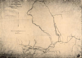
Sketch map of part of British Columbia showing trails and routes of communication
Part of Major Matthews collection
Item is a photostatic copy of a manuscript map showing trails and routes of communication in a portion of British Columbia from the Canada-U.S. border in the south to Seaton Lake in the north, and from the coast to Vermillion in the east. The section of coastline extends from Semiahmoo Bay in the south to Point Atkinson in the north. Map shows the location of mule trails and wagon roads, and includes a trail in progress from New Westminster to Burrard Inlet (North Road), trails from Whatcom to Hope and Semiahmoo to Derby, the Hudsons Bay Brigade Trail, Douglas Road, a trail proposed by Colonel Moody from New Westminster to Fort Hope, and the Dewdney Trail. Included with the map is a 1949 letter from Major Matthews, City Archivist, to J.M. Pearce in which Matthews describes the map, and a 1952 enquiry from L.B. [Housler] for a map showing the Dewdney Trail.

Part of City of Vancouver Archives technical and cartographic drawing collection
Item is a re-published version of a geographical map originally published by the Colony of British Columbia, Office of Lands and Works. The map shows topography as hacheurs, and depicts fur trade trails and forts and physical features of the area which made up the Colony of British Columbia as of 1862.

Sketch map of part of British Columbia showing trails and routes of communication
Part of Major Matthews collection
Item is a photostatic copy of a manuscript map showing trails and routes of communication in a portion of British Columbia from the Canada-U.S. border in the south to Seaton Lake in the north, and from the coast to Vermillion in the east. The section of coastline extends from Semiahmoo Bay in the south to Point Atkinson in the north. Map shows the location of mule trails and wagon roads, and includes a trail in progress from New Westminster to Burrard Inlet (North Road), trails from Whatcom to Hope and Semiahmoo to Derby, the Hudsons Bay Brigade Trail, Douglas Road, a trail proposed by Colonel Moody from New Westminster to Fort Hope, and the Dewdney Trail. Included with the map is a 1949 letter from Major Matthews, City Archivist, to J.M. Pearce in which Matthews describes the map, and a 1952 enquiry from L.B. [Housler] for a map showing the Dewdney Trail.
![[Phillip Sullivan]](/uploads/r/null/2/2/22125fe7e955b8ecc888c2caebc058031383e9c5d422af0de2f9e32d99970f1d/5fb35d4d-7cb1-4940-99b0-8f1b1eed6766-A35099_142.jpg)
Part of Major Matthews collection

The wagon road at the 17 mile post - road to Goldfields
Part of Major Matthews collection
Photograph shows a road on the side of a mountain
![[Hugh McRoberts]](/uploads/r/null/d/5/d5d4316e30c9561b0947b134e622471b824cfc0885afc898324eca1c1166e8f0/d1910833-a3be-47df-8490-506b55c50e9a-A61987_142.jpg)
Part of Major Matthews collection
Full-length portrait
![[Studio portrait of unidentified First Nations Woman in European-style clothing]](/uploads/r/null/c/f/cf11f0c4bfbbb5eac2feb54623e30aa4980c1e022474fce717a5a9fbd73933fd/2f2db698-95d1-49ea-9889-fe35db48bfcf-A22897_142.jpg)
[Studio portrait of unidentified First Nations Woman in European-style clothing]
Part of Major Matthews collection
![[Studio protrait of an unidentified First Nations man]](/uploads/r/null/c/f/cfa04a7d3ec559b6eaed021b24024838b3c10fa480c3d5fcf685c6284ef7b454/5f97521f-f439-4ef5-b94d-3c9f522be313-A22889_142.jpg)
[Studio protrait of an unidentified First Nations man]
Part of Major Matthews collection
![[Unidentifed First Nations man]](/uploads/r/null/c/2/c2a431c7c4c44e23ff5183d28e0e55c903a8155f203b90d455f5917f5a414b31/5c47770a-7ca0-45a6-be0e-51680e5e9e24-A22905_142.jpg)
[Unidentifed First Nations man]
Part of Major Matthews collection

Deadman's Island - Vancouver Island
Part of Major Matthews collection
![H.M. Ship "Chanticleer" [in Esquimalt harbour, Vancouver Island]](/uploads/r/null/4/7/477d57b381497480e2fc96b3ff9f2a5b880f1c0b9c659e5d876bafc40b05cef9/1d63151b-557e-4e32-9a47-7548d15ebcb3-A22854_142.jpg)
H.M. Ship "Chanticleer" [in Esquimalt harbour, Vancouver Island]
Part of Major Matthews collection
Photograph shows the ship at anchor with the sails open for drying.

Map of a portion of British Columbia
Part of City of Vancouver Archives technical and cartographic drawing collection
Item is a map showing exploration routes by Lieutenant Palmer, R.E., May and June 1859; Lieutenant Mayne, R.N., May 1859; and Lieutenant Palmer, R.E., Sept. & Oct. 1859. The map also shows "practicable roads" in the southwestern portion of British Columbia. Annotations are colour added to the map to more easily distinguish the different routes depicted.

Part of Major Matthews collection
![China Bluff on way to Boston Bar - Frazer [Fraser] River](/uploads/r/null/7/b/7bd123659bbb4dc0aa3970fe573df39cbf2f6b12f7e5747300a89968847289cf/51f452e5-0b09-4380-a408-9ad604c969d5-A22917_142.jpg)
China Bluff on way to Boston Bar - Frazer [Fraser] River
Part of Major Matthews collection
![Suspension Bridge - Frazer [Fraser] River](/uploads/r/null/f/d/fd8dc71b367897655629c415eb95fd5db096c3073e913c642d2318d041a2b6e5/e03316a1-8594-4826-b4c1-8663a9c77c25-A22915_142.jpg)
Suspension Bridge - Frazer [Fraser] River
Part of Major Matthews collection
![[Group portrait of three unidentified First Nations People]](/uploads/r/null/9/8/98b7d5f143bcc3b50e644b6c275f3519989d80a4565dcbb979e4b9d276a75b69/dfb85ca1-741e-4164-949d-45a2ad9a3c58-A22884_142.jpg)
[Group portrait of three unidentified First Nations People]
Part of Major Matthews collection
Photograph shows woven hat and basket.
![[Studio portrait of an unidentified First Nations man]](/uploads/r/null/2/b/2b2b97bc28f0ca3e7b3e5e8ce4663ec0824ed6b35c5c9e3253d512248f3c1a7b/e55ba3b7-b8fb-427d-b9ba-b55a3f8adf53-A22890_142.jpg)
[Studio portrait of an unidentified First Nations man]
Part of Major Matthews collection
Photograph shows woven hat.
![[Studio portrait of an unidentified First Nations man]](/uploads/r/null/b/4/b446336d6c4e01c95c6bbf3257e0448f00c250a86aed9b92eb79a0ceea48836c/0b859628-08e1-44fd-9140-5ac223dcccb4-A22891_142.jpg)
[Studio portrait of an unidentified First Nations man]
Part of Major Matthews collection
![[Unidentified First Nations man]](/uploads/r/null/9/9/9975b32de2d45cf273a3a2d2b32177944e4718c8d363a49d7679399f5f0d1565/6481c7a9-999d-4937-b698-5669b5dbab70-A22888_142.jpg)
[Unidentified First Nations man]
Part of Major Matthews collection

Head and shoulders portrait of an unidentifed First Nations man
Part of Major Matthews collection
![[Two unidentified First Nations men]](/uploads/r/null/6/f/6f14fce4fee65001a878a3ff3bb540a8296751ec88e3d0c64a9b2b8c104f89a5/bc0b6787-8bf2-4686-9dbb-677cc6cb00de-A22894_142.jpg)
[Two unidentified First Nations men]
Part of Major Matthews collection
![[Mrs. Benjamin Springer (nee Frances Nias)]](/uploads/r/null/c/a/ca224d65615780f4d8db5b187e45a1ca4c1fe491e81acf2c4b841e6883315c99/7464c91c-c001-4588-bfc5-f425b0f080dc-A34654_142.jpg)
[Mrs. Benjamin Springer (nee Frances Nias)]
Part of Major Matthews collection
Head and shoulders portrait
Part of Major Matthews collection
![[Abington Herbert Ridley]](/uploads/r/null/c/1/c19918cca4ac031d788ce72d0f792c1cd7df58f3ab054dc328ca2dd5a04c6568/f72e179e-8ea6-4f9e-9bcb-265314ab2cab-A35360_142.jpg)
Part of Major Matthews collection
Studio portrait
Part of City of Vancouver Archives technical and cartographic drawing collection
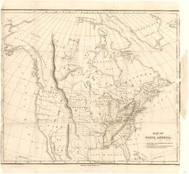
Item is a map showing "Mr. Stuart's route through the United States, and Canada in 1828, 29 & 30" and "the boundary of the United States, both on the side of the British Possessions, & those in Mexico." The northern border of United States territory west of the Rocky Mountains is incorrectly noted at 54/40, to reflect American claims of the time.
![[Logger]](/uploads/r/null/4/f/8/4f8a77f0217af552ab3f639f05178ec6311cad7fedbaa339e41f162e4d92d07d/ad98ff7a-f511-4f10-a82d-c18d78ea67ae-CVA1385-21_142.jpg)
Part of O.B. Allan Ltd. fonds
Item is photograph of logger with large felled tree.
![[Loggers]](/uploads/r/null/7/0/3/703e201e1e0357447fdac79dfbfe82652e9696c2ced222e46aa9e639868a66e1/6cf3d49b-c7f4-4e81-8d65-43636533dfda-CVA1385-22_142.jpg)
Part of O.B. Allan Ltd. fonds
Item is photograph of four loggers with large felled tree.

Part of City of Vancouver Archives technical and cartographic drawing collection
Item is a map showing the Pacific Coast of British Columbia and Washington and Oregon states as surveyed by French explorer Jean-Francois de Galaup (Laperouse) in 1786, and the routes of his ships Astrolabe and Boussole. The map shows the Pacific coastline from Cap Rond (Tillamook Head) in Oregon at latitude 45 degrees and 40 minutes in the south to Baeie de Clonard (Beresford Bay, northwestern tip of Haida Gwaii) in British Columbia at latitude 54 degrees and 10 minutes in the north. Other major place names on the map include Nootka, Pointe Boisee, Baie St. Louis, Iles de Sartine, Mont Fleurieu, Cap Fleurieu, Cap Hector, Mont de la Touche, Baie de la Touche, and Baie de Clonard. Vancouver Island is shown as part of the mainland. Map includes latitudes and longtitudes as well as indication of elevations. Map is a plate from the "Atlas de Voyage de la Perouse".

Border of "bottles" at Schuchemelch
Part of John Davidson fonds