![[Head and shoulders portrait of] Captain Buckley V.C.](/uploads/r/null/b/c/bc3cb5b6088c689792a004fee0cee107bfff853c886f661c4bf1a698298f6359/32cd4f70-f36f-4e08-b738-c02eee905c97-A22842_142.jpg)
[Head and shoulders portrait of] Captain Buckley V.C.
- AM54-S4-1-A-6-: A-6-91
- Item
- [186-?]
Part of Major Matthews collection
19141 results with digital objects Show results with digital objects
[Head and shoulders portrait of] Captain Buckley V.C.
Part of Major Matthews collection
![[Head and shoulders portrait of] Commander Denny - H.M. Gun Boat "Forward"](/uploads/r/null/f/a/fa41824a5e1c369426a24d783d9ad570e45dc5127dce164983c7048f2a086525/5f4c52c1-a647-4eab-b24c-0c3b0426aef8-A22828_142.jpg)
[Head and shoulders portrait of] Commander Denny - H.M. Gun Boat "Forward"
Part of Major Matthews collection
![[Head and shoulders portrait of] Commander Liddell](/uploads/r/null/8/d/8de884c27b63a354dfb49dfd4ca7dc18482f65bc7cf759ca965dc74b405cd3e0/3992a59c-8628-4298-a16b-2971ca557ad1-A22777_142.jpg)
[Head and shoulders portrait of] Commander Liddell
Part of Major Matthews collection
![[Head and shoulders portrait of] Commander Purvis H.M. Ship "Topaze"](/uploads/r/null/d/1/d1b0cff1a0d1c353f77d87e22f1d7c8218fb29bb45e1f0525d9b4d9aa684817f/0701dea3-2959-44cc-9d71-821c6869589d-A22841_142.jpg)
[Head and shoulders portrait of] Commander Purvis H.M. Ship "Topaze"
Part of Major Matthews collection
![[Head and shoulders portrait of] Doctor Burton](/uploads/r/null/9/5/959f14bba1473b347c63582aeb48517d5bb1dcc6c1e417ccb7f6692621a77ab2/9322b890-4ab5-41ed-9705-864d3d4cbeba-A22781_142.jpg)
[Head and shoulders portrait of] Doctor Burton
Part of Major Matthews collection
![[Head and shoulders portrait of] Frank Brooke](/uploads/r/null/0/4/044db313b90776930a9b49f014368f17114267912a491ac95e0b8a89d5506993/c8b4dc4b-ae89-48a8-9c15-c1ec8171ed92-A22808_142.jpg)
[Head and shoulders portrait of] Frank Brooke
Part of Major Matthews collection
![[Head and shoulders portrait of] Lieutenant Hastings](/uploads/r/null/f/d/fdc10f28a8cba628e18dee2973412a03826556a101398315244fadaa5d9d147a/eb7a8b24-5621-4c33-9ab4-5b77d087d10e-A22784_142.jpg)
[Head and shoulders portrait of] Lieutenant Hastings
Part of Major Matthews collection
![[Head and shoulders portrait of] Lieutenant MacLean](/uploads/r/null/e/7/e78d1cbf02771018ab64fe965e71641941cd131e446c8eb16eeb4772a6112b35/a8841cf9-2159-46c8-a4d0-40edbed99360-A22786_142.jpg)
[Head and shoulders portrait of] Lieutenant MacLean
Part of Major Matthews collection
![[Head and shoulders portrait of] Mr. Perry](/uploads/r/null/6/e/6e2caf19e7663233d963f8392f22fc7293325af82c28e94479c59bcf16cb0831/28253494-d395-4b64-91b2-aa6886ef994e-A22775_142.jpg)
[Head and shoulders portrait of] Mr. Perry
Part of Major Matthews collection
![[Head and shoulders portrait of] Mr. Robinson](/uploads/r/null/5/a/5a12cf4f0ac3b984f153b94df1bac27776345fb42e87848599f7236076fe59f7/50e8a0d3-dd61-489d-b382-cdd0f03c0a1e-A22791_142.jpg)
[Head and shoulders portrait of] Mr. Robinson
Part of Major Matthews collection
![[Studio portrait of an unidentified First nations man]](/uploads/r/null/9/0/900f3e247e6278725127aaa96fa2f51a7a160884b8a013ff658fe30c83930464/6eb3cab3-7173-4d85-823d-0b7b9771dca5-A22899_142.jpg)
[Studio portrait of an unidentified First nations man]
Part of Major Matthews collection
![[Studio portrait of an unidentified First Nations woman]](/uploads/r/null/4/4/44af8aed4e252c82d6954918593d68bc985ee52ed721bf07926f4d8878b2f7a1/2919720a-7f8d-48ed-93cc-60d978930349-A22892_142.jpg)
[Studio portrait of an unidentified First Nations woman]
Part of Major Matthews collection
![[Studio portrait of] Admiral Hastings](/uploads/r/null/2/7/27e96d96a7f17f111a7e252a54ac76b9922c459050f0a347df383c4224121bb9/fbd2ee88-e792-43c1-a668-968b79b87e37-A22771_142.jpg)
[Studio portrait of] Admiral Hastings
Part of Major Matthews collection
![[Studio portrait of] Arthur and Frank Brooke](/uploads/r/null/d/2/d2c13269acd3309f35d6a7bfc7103c641e9ebce1c5a66e9c8e8fbbfb7e583965/7495d46a-9281-4195-ae6a-8947f5cc98d6-A22774_142.jpg)
[Studio portrait of] Arthur and Frank Brooke
Part of Major Matthews collection
![[Studio portrait of] Captain Dawkins](/uploads/r/null/1/2/125d870fe50165cad4ec003aa07ba97b21d280347f9464c7d1f1d1a44812f5b5/f47333a5-c15b-4f0e-9913-6cc17eeed6b4-A22772_142.jpg)
[Studio portrait of] Captain Dawkins
Part of Major Matthews collection
![[Studio portrait of] Captain Porcher - H.M.S. "Sparrowhawk"](/uploads/r/null/7/3/738d19fd50ccfc1c35546039d9d47c4bea08d05b79a7816499d3114169e26826/694d7a70-5b3b-4aef-bafe-b6551f4cd8af-A22827_142.jpg)
[Studio portrait of] Captain Porcher - H.M.S. "Sparrowhawk"
Part of Major Matthews collection
![[Studio portrait of] Commander Liddell](/uploads/r/null/3/e/3e0a5ecf8d844037e3460992ca661a4feaa4b4b6750c78ba9cda966845bec715/a7442f8e-c895-4c01-8093-f9165dd7d72f-A22793_142.jpg)
[Studio portrait of] Commander Liddell
Part of Major Matthews collection
![[Studio portrait of] Commander Mist - H.M.S. "Sparrowhawk"](/uploads/r/null/f/8/f816e7137a0d86cc722beca109d415f35a6dbf572f77f0717a9e5aa7d0bce75a/fe7e31bb-4e20-4475-960f-86e4f849da5d-A22831_142.jpg)
[Studio portrait of] Commander Mist - H.M.S. "Sparrowhawk"
Part of Major Matthews collection
![[Studio portrait of] Majors Hitchcock and Travers 24th Regiment](/uploads/r/null/7/f/7fde6129fc3cba0a1d3ec8d93309cabff301f0ad61e420b3330bcedb648a0021/4888abc8-b964-4e7c-9a78-5dccb18d9759-A22857_142.jpg)
[Studio portrait of] Majors Hitchcock and Travers 24th Regiment
Part of Major Matthews collection
![[Studio portrait of] The Hon[ourable] Mrs. Terningham](/uploads/r/null/6/c/6cf450db451dfe156fdbb7922c027737565d98fe405a3c98e89b17ac186614bd/4b83810b-603e-4abc-861c-9c6a167a1dce-A23114_142.jpg)
[Studio portrait of] The Hon[ourable] Mrs. Terningham
Part of Major Matthews collection
![[Two unidentified First Nations men]](/uploads/r/null/6/f/6f14fce4fee65001a878a3ff3bb540a8296751ec88e3d0c64a9b2b8c104f89a5/bc0b6787-8bf2-4686-9dbb-677cc6cb00de-A22894_142.jpg)
[Two unidentified First Nations men]
Part of Major Matthews collection
![[Two unidentified First Nations women]](/uploads/r/null/7/f/7fd546ef7fb14d7b58d2ebb1ea2bb458d8181f8a276f1ebb5890a0266de7fd64/1093742e-f7aa-4579-b3e7-78064ad47ec2-A22887_142.jpg)
[Two unidentified First Nations women]
Part of Major Matthews collection
![[Unidentified First Nations Women and Children]](/uploads/r/null/e/5/e5fd7153f84d62f08651b114525ce496cfb5c48ec486588ead796aae173ca396/7f42de2a-d969-4d11-a302-023c4f5d544d-A22895_142.jpg)
[Unidentified First Nations Women and Children]
Part of Major Matthews collection
![[View of buildings at] Coquimbo](/uploads/r/null/1/8/182ef865443e66dfbf94d83977b0aeb2d617051537fdaf9a8088e60ba7a1e391/9951bd01-0e43-470a-a01a-ad823f456da3-A23127_142.jpg)
[View of buildings at] Coquimbo
Part of Major Matthews collection
![[View of ship at anchor off] Dartmouth](/uploads/r/null/4/f/4f1ab19965297c445dfac42c102c60c917d6b4d8c059331b3546904333c2da5f/e155585a-c6cd-4528-b815-e41a5799749b-A22868_142.jpg)
[View of ship at anchor off] Dartmouth
Part of Major Matthews collection
![[Wooden representation of the crucifixion of Jesus Christ]](/uploads/r/null/c/7/c765412d531b79af7039dd87a45e2cd0c0a15549765f77abe3ac46169ae6bf73/b8188419-caae-4e5c-aa7e-189bb748f316-A22824_142.jpg)
[Wooden representation of the crucifixion of Jesus Christ]
Part of Major Matthews collection

Admiral Hastings and Group of Officers on board "Sparrowhawk"
Part of Major Matthews collection

Alcatraz Island - San Francisco
Part of Major Matthews collection

Amateur Group of Officers in Uniform
Part of Major Matthews collection
Photograph identifies officers: Dr. Eustace, Pirie, Brodie, Wright, Hastings, Torry, Logan, Walker, Ashington, Stock, Dickens, Whyte, Bentley.
![Boy [on horse] selling fruit](/uploads/r/null/c/7/c7afa61bac3af230635752591b77b91656e3ae5db62f56b2a5654c6adeac261b/6f16c9c5-cd49-44ab-9541-432eb570e9ed-A23125_142.jpg)
Part of Major Matthews collection
![Bullock Waggon [wagon]](/uploads/r/null/c/d/cd19ecce2d148a6291f007a8d38f1c37ea0976dfcd2649ed0f767428910f0c93/656f18b8-b296-40ae-a40e-fce1d21de9be-A23123_142.jpg)
Part of Major Matthews collection

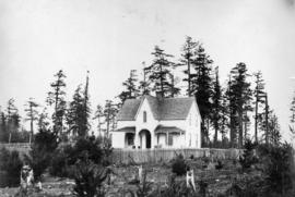
Colonel Foster's House - Esquimalt
Part of Major Matthews collection

Fisguard Light House - Esquimalt
Part of Major Matthews collection
![Group [portrait] of Satellite's Officers](/uploads/r/null/c/3/c3e33b3ac87c5800d9da2cf65af5f4ee0cd60ed058c5cae2fe55bf464bc8351b/03fdaddc-c38d-450a-ac68-3e61601925cf-A22825_142.jpg)
Group [portrait] of Satellite's Officers
Part of Major Matthews collection
Officers identified: Lieut. Hanmer, Capt. Edge, Lieut. Wright, Dr. Eustace, Mr. Brown
![Group of Servants [at] Maple Bank](/uploads/r/null/e/b/ebddb7e4838eae0324f37647aba3930de8a986c4742f68f18e1818c0d1bdec07/ae2a0f95-660a-4f18-ac08-c04c075dd3e9-A22874_142.jpg)
Group of Servants [at] Maple Bank
Part of Major Matthews collection
Part of Major Matthews collection
The collection consists of Major Matthews' private papers and records gathered by Matthews relating to the history of Vancouver when he was City Archivist. It includes numerous military records; collected photographs, [186-?]-1968; correspondence and pamphlets relating to Vancouver's water supply; examples of letter-heads, business stationery, tickets, notices and so on used in Vancouver in the 1880s; records of the planning and building of the First Narrows Bridge, Vancouver; an obituary book of clippings from newspapers; correspondence and clippings relating to unemployment and relief in Vancouver, 1931-1939; clippings relating to mayors of Vancouver, 1932-1971; clippings, photographs and menus relating to the visit of H.R.H. Princess Elizabeth and the Duke of Edinburgh, 1951; clippings relating to distinguished visitors to Vancouver 1928-1953; a scrapbook of clippings relating to pioneer Vancouver aviator, William Stark, 1912; genealogical records relating to the family of J.S. Matthews; numerous topical and categorical files relating to a wide variety of subjects; and a series of index cards describing the history of street and place names in Greater Vancouver.
Matthews, James Skitt, Major
![[Abington Herbert Ridley]](/uploads/r/null/c/1/c19918cca4ac031d788ce72d0f792c1cd7df58f3ab054dc328ca2dd5a04c6568/f72e179e-8ea6-4f9e-9bcb-265314ab2cab-A35360_142.jpg)
Part of Major Matthews collection
Studio portrait
![[George Chiffence]](/uploads/r/null/e/5/e526522f1c1cb42adb5cddc50d4765180e38f41ec4fc861a5b9ca4c6362b8e6a/6028086f-2201-43d3-a9a7-e3965eb1107a-A35985_142.jpg)
Part of Major Matthews collection
Studio portrait
![[Mrs. Benjamin Springer (nee Frances Nias)]](/uploads/r/null/c/a/ca224d65615780f4d8db5b187e45a1ca4c1fe491e81acf2c4b841e6883315c99/7464c91c-c001-4588-bfc5-f425b0f080dc-A34654_142.jpg)
[Mrs. Benjamin Springer (nee Frances Nias)]
Part of Major Matthews collection
Head and shoulders portrait

Map showing the line of boundary between the United States & British possessions
Part of Major Matthews collection
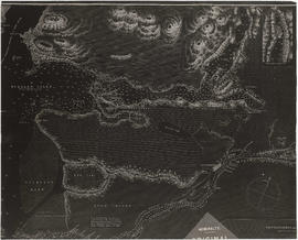
Four cross sections, mainland to Vancouver Island
Part of Major Matthews collection
Item is a sheet depicting four cross sections of surface and underwater topography between the North American continent and Vancouver Island at north latitudes of 49 degrees, 48 degrees 45 minutes, 48 degrees 35 minutes, and 48 degrees 25 minutes. Depths
Part of Major Matthews collection
Fraser River and Burrard Inlet
Part of Major Matthews collection

Fraser River and Burrard Inlet
Part of Major Matthews collection
Fraser River and Burrard Inlet
Part of Major Matthews collection

Fraser River and Burrard Inlet
Part of Major Matthews collection
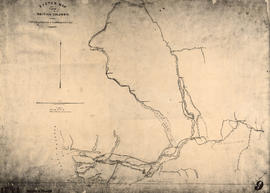
Sketch map of part of British Columbia showing trails and routes of communication
Part of Major Matthews collection
Item is a photostatic copy of a manuscript map showing trails and routes of communication in a portion of British Columbia from the Canada-U.S. border in the south to Seaton Lake in the north, and from the coast to Vermillion in the east. The section of coastline extends from Semiahmoo Bay in the south to Point Atkinson in the north. Map shows the location of mule trails and wagon roads, and includes a trail in progress from New Westminster to Burrard Inlet (North Road), trails from Whatcom to Hope and Semiahmoo to Derby, the Hudsons Bay Brigade Trail, Douglas Road, a trail proposed by Colonel Moody from New Westminster to Fort Hope, and the Dewdney Trail. Included with the map is a 1949 letter from Major Matthews, City Archivist, to J.M. Pearce in which Matthews describes the map, and a 1952 enquiry from L.B. [Housler] for a map showing the Dewdney Trail.
![Country lands, New Westminster District [D.L. 185]](/uploads/r/null/2/f/f/2ff00fcb19a3dd23ff02f3355264a2fef808da9c2362a01bc084c87c334bbb27/0143c5f1-96bf-4733-b1d3-2386ba496659-LEG1801_142.jpg)
Country lands, New Westminster District [D.L. 185]
Part of Major Matthews collection
Records relating to claim of D.L. 185 ("Three Greenhorns")
Part of Major Matthews collection
File consists of tracings and negative photostat copies of records relating to the claim, surveying and subdivision of D.L. 185 (Vancouver's West End neighbourhood, between the current Burrard Street and Stanley Park).