British Columbia - Vancouver skyline
- AM1435-: CVA 1435-35
- Item
- [197-?]
Item is aerial photograph of Stanley Park and Coal Harbour.
780 results with digital objects Show results with digital objects
British Columbia - Vancouver skyline
Item is aerial photograph of Stanley Park and Coal Harbour.

British Columbia - Vancouver skyline
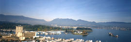
Item is aerial photograph of downtown Vancouver looking north west towards Stanley Park.

British Columbia - Vancouver skyline
Item is aerial photograph showing a panoramic view of downtown Vancouver looking north west towards Stanley Park and Coal Harbour.

British Columbia - Vancouver skyline
Item is aerial photograph showing Stanley Park and Coal Harbour.

British Columbia - Vancouver skyline
Item is aerial photograph of downtown Vancouver looking north west towards Stanley Park.
British Columbia - Vancouver skyline
Item is aerial photograph of Stanley Park and Coal Harbour.

British Columbia - Vancouver skyline
Item is aerial photograph of downtown Vancouver looking north west towards Stanley Park.

British Columbia - Vancouver skyline
Item is aerial photograph showing a panoramic view of downtown Vancouver looking north west towards Stanley Park and Coal Harbour.

British Columbia - Vancouver skyline
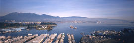
Item is aerial photograph showing a panoramic view of downtown Vancouver and Burrard Inlet.

British Columbia - Vancouver skyline
Item is photograph showing an aerial view of Burrard Inlet showing the southern shoreline and parts of Stanley Park.

British Columbia - Vancouver skyline
Item is aerial photograph showing part of downtown Vancouver, Stanley Park and Coal Harbour.

British Columbia - Vancouver skyline
Item is aerial photograph showing downtown Vancouver looking north west towards Stanley Park.

British Columbia - Vancouver skyline
Item is aerial photograph showing downtown Vancouver and Burrard Inlet.

British Columbia - Vancouver skyline
Item is aerial photograph of downtown Vancouver looking north west towards Stanley Park.

British Columbia - Vancouver skyline
Item is photograph of Stanley Park taken through an office window.

British Columbia - Vancouver skyline
Item is photograph showing an aerial view of Burrard Inlet showing the southern shoreline and parts of Stanley Park.

British Columbia - Vancouver skyline
Item is aerial photograph of downtown Vancouver and Burrard Inlet.
![[Houses in Kitsilano]](/uploads/r/null/7/e/0/7e04217e7957c0cf375ee29846bc04c16dc03d0edc9159cbe9a098035b3bc611/5737f27b-73a6-44a7-95c3-6f0befffbbe7-CVA808-4_142.jpg)
Part of City of Vancouver fonds
![[Houses in Kitsilano]](/uploads/r/null/3/4/4/344d15796f2c3500294073c90fa782c0f0f8a63a01053fb3c2784628527b336b/53f61997-50b3-44f2-9970-73647972523e-CVA808-5_142.jpg)
Part of City of Vancouver fonds
![[Houses in Kitsilano]](/uploads/r/null/a/3/f/a3f2366e0cb3221dc412ce3a991413c10590721500a7c5ead1b32b4de3ee3e8e/ffe1bef9-efb5-41aa-a862-59a8dd8597c8-CVA808-6_142.jpg)
Part of City of Vancouver fonds
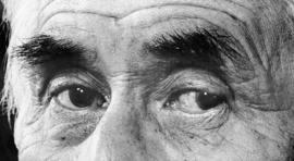
Item is a panorama photograph of a close-up of the eyes of Chief Dan George.
Panoramic view of downtown Vancouver from Fairview
Part of City of Vancouver fonds
This item is a panoramic image of the north and south shores of False Creek, downtown Vancouver, and the North Shore mountains, taken from a high vantage point near Willow or Heather Streets. It shows the industrial areas to the east of the Connaught Bridge and on the north shore of False Creek, as well as vacated land on False Creek's south shore when it was being prepared for the development of housing and public spaces. The eastern end of Granville Island is also shown.
Anonymous
![[View of Mount Pleasant]](/uploads/r/null/0/c/9/0c9db5e81df211f273f5e890c4cf2f482734489cf47c53831e2f430410336c9b/259201ec-18df-4a3e-9317-7b6aa211e33b-CVA808-9_142.jpg)
Part of City of Vancouver fonds
![[View of Mount Pleasant]](/uploads/r/null/9/c/d/9cdedd7465a41bd387e640cf629625fb867c074fe7a89a2eacf6d02d89268aae/aef32311-b1a1-4f41-88c3-68eb30b0cf98-CVA808-8_142.jpg)
Part of City of Vancouver fonds
Photograph is taken of the 500 block of East 5th Avenue.
![[View of Mount Pleasant]](/uploads/r/null/f/8/8/f883b50f34df11f05b1c107ec0c789d80f30e304660c865e989b0dd1446b1471/2ce083c1-779d-4228-bfb6-feb4b18d2284-CVA808-13_142.jpg)
Part of City of Vancouver fonds
Photograph is taken from the 500 block of East 6th Avenue.
![[View from Mount Pleasant]](/uploads/r/null/e/0/6/e0679175bd2da811f7cfb86a720d66936d45cebb7c6e87adbea4ec36fca5c3f3/f2ad982b-1698-420a-9377-b6d512781729-CVA808-7_142.jpg)
Part of City of Vancouver fonds
Photograph is taken from the corner of St. George Street and 6th Avenue. Photograph shows the house at 489 6th Avenue as well as other houses and buildings.
![[View of Mount Pleasant]](/uploads/r/null/c/9/a/c9a8d890b54f8204f58dffbfd0ed278bca5b265b0285ea5c6522c32d3423e532/22351675-2983-49e8-90a6-1c3117fd3b66-CVA808-10_142.jpg)
Part of City of Vancouver fonds
Photograph is taken from the corner of the 500 block East 6th Avenue.
![[View from Mount Pleasant]](/uploads/r/null/6/1/7/61796b9322b742704a59f1d8f02bd6a4589a65cb75dd028eb892e3848324ad1d/de4f5049-8b10-41eb-8538-637f61f7c335-CVA808-11_142.jpg)
Part of City of Vancouver fonds
Photograph is taken from the corner of the 600 block East 7th Avenue.
![[View of Mount Pleasant]](/uploads/r/null/f/c/d/fcd28e8cf7d39277126c04c41ab4e76fa840bc648777bb45ec920b041b3bc0e9/33b86ff1-4a55-40a3-8490-7eb4f36ffeb5-CVA808-12_142.jpg)
Part of City of Vancouver fonds

Panorama view of the National Harbours Board fish wharf
Item is a photograph made by the City of Vancouver Archives out of the three portions of a panoramic view of the National Harbours Board fish wharf.
![[Construction of the Dedicated Fire Protection System Kitsilano extension in Vanier Park]](/uploads/r/null/6/5/654eb969bf0acc791a1f74b8115765c2b5f26111109b0493cb9b829d1a62bb5e/db3f3aee-c718-4c66-9712-5523a45f3578-CVA1376-43_142.jpg)
[Construction of the Dedicated Fire Protection System Kitsilano extension in Vanier Park]
Photograph shows the 1200 and 1300 blocks of Chestnut Street, the Vancouver Museum and the DFPS pipeline laid out in the park during construction.
![[Construction of the Dedicated Fire Protection System Kitsilano extension in Vanier Park]](/uploads/r/null/b/5/b5cf3880be1cdc714e93bb9ed0fd9cd2e3c1eda6bc065aba1212da232c58acea/c546f069-a0a0-4817-97e6-d4e3e9f21598-CVA1376-43_142.jpg)
[Construction of the Dedicated Fire Protection System Kitsilano extension in Vanier Park]
Photograph shows the Vancouver Museum and parking lot, part of the Gordon MacMillan Southam Observatory, the DFPS pipeline, bulldozer and excavation machinery.