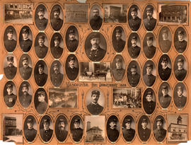
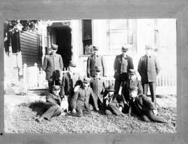
![[Group portrait of Vancouver Veteran Volunteer Firemen]](/uploads/r/null/9/a/9/9a985186d40ac4957f78f90ab726fdfd8484f87ac1b682dc1523fd2fe8548219/c0a7f95b-3e83-47f6-ab90-8d9961730c77-CVA354-371_142.jpg)
[Group portrait of Vancouver Veteran Volunteer Firemen]
- COV-S280-: CVA 354-371
- Item
- 1886
Part of City of Vancouver fonds
Item is a photograph showing F. Gladwin, R. Leatherdale, F. Duhamil, J. Moran, P. Larsen, J. Hoskins, W.S. Cook, J.A. McAllister, T. Becket, J.J. Garvin, E.C. Britton, C. [Gigier?], W. Dawsey, G. Thomas, W. McGirr, sq.. Ramage, G.F. Upham, C.M. Hawley, A.W. Cameron, J. McDonald, J.W. Campbell, W. McKinnon, H.E. Campbell, J.H. Carlisle, J. Metier, A. Tyson, and T.W. Lillie.


![Champion Hose Team [standing beside hose and roller]](/uploads/r/null/3/e/c/3ecc7ca229d43c390663772e48da8c7ee1f3f5b027a977a2115802af280587c8/01e03171-960b-4b77-a8f1-174d9e32577b-CVA354-003_142.jpg)
![Champion Hose Team of British Columbia [from Vancouver Fire Department with hose and roller]](/uploads/r/null/8/4/a/84a2b73c1f67eba25183b31f8fbbb7e26e74a68f9b0c0a28a0fdbf2551603617/3ce25258-f2c5-420c-ab0d-52cfafab16f5-CVA354-001_142.jpg)


![[Firehall No. 2, 700 block Seymour Street and adjacent house with family before house]](/uploads/r/null/6/a/d/6ad6890a00f2f454cda679cddad6276ee9a3dad50cfb5a0d99b649781431aa38/cfb40eff-4663-46e1-afc8-340dc27a2a36-CVA354-004_142.jpg)

![[City Scavenging Staff on street with cart]](/uploads/r/null/f/4/f4e07edd8b377dd69f2b921c8235fa7b79dcab417b62b41f973a7bff8ce6b402/107c3cec-db79-4394-88d2-e860595ad93d-A16574_142.jpg)


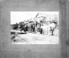
![[Horse drawn hose wagon sitting in firehall]](/uploads/r/null/0/1/b/01b019e1f2c4a357c3fc7f71f12df381b7d4b2f56625724992b8f823ca05394d/e887c401-8a97-493e-9550-145191cc44ed-CVA354-334_142.jpg)
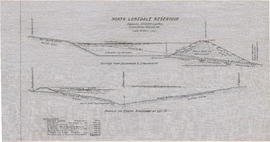
![Contour plan 220a [Mt. Pleasant]](/uploads/r/null/b/d/bd5c7afeea1a507ba6bc282b904c55c40d1119da939738b1911ba9fd99e6bd21/21ae5b59-321b-4488-bdc6-e782f391b8ea-MAP690_142.jpg)
![[Group portrait of men gathered for Fire Chief's Convention]](/uploads/r/null/b/4/c/b4c75bd512ded60e2a0a7f60915f9d692eebd2f64e45548c5727357a40422d47/df0fa1e3-345a-401f-82e1-40ba4ba593d7-CVA354-005_142.jpg)
![[Three horses pulling firefighting apparatus and firefighters down a downtown street]](/uploads/r/null/b/3/c/b3ce5cd50bd21590baa6bc034b2e2647852518c0c8a32ef29537fd2523e1e68f/277b5079-9fe5-47c5-baea-61e55464afec-CVA354-442_142.jpg)
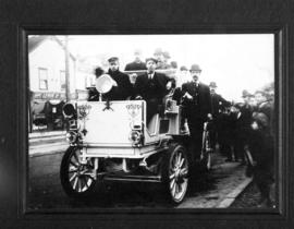
![[Chief J.H. Carlisle seated in horse-drawn buggy - for Victoria Day parade?]](/uploads/r/null/c/f/4/cf47d87104515af96347ea50dabbd2e7fe75393338faf7606e81097276a9bc06/660e4aab-720e-478b-b9d3-b0c05582d8ae-CVA354-083_142.jpg)

![Chief Carlisle and the old horse Tanner [in a parade]](/uploads/r/null/3/5/3/353295deafb1cade11460ecffd1db28468c66b51466ed8cd5d2b2bfedea30255/92d0546a-519c-4741-a70e-647aa4bfae86-CVA354-008_142.jpg)
![Plan shewing pipe line right of way through parts of [District] Lots 673, 792, 1248 & 8740](/uploads/r/null/3/e/d/3edc1c60ffff3e127a7deca4ea557003830885586aca147517f20701ee3a0e82/e2a2ed7a-ca07-4658-af4f-9e2675d8a5b6-LEG1153_142.jpg)


![Plan of pipe line right of way through D.L. [District Lot] 1242 Gpl. NWD [New Westminster Distric...](/uploads/r/null/c/3/3/c33ab3d09d1709249692d18d57987bf31fd6004f76cbe439d3486f474d8af1b6/62bde213-49bb-45eb-93e1-51857e60fa4b-LEG1153_142.jpg)


![Sanitary arrangement [public toilets]](/uploads/r/null/9/c/0/9c0414e241733e699a491cd4d8963d04a2e1dc64568daa3bf1ba3d49b409ea35/5c96f543-e53d-4b33-8a0c-43526af7e8d6-LEG1800_142.jpg)


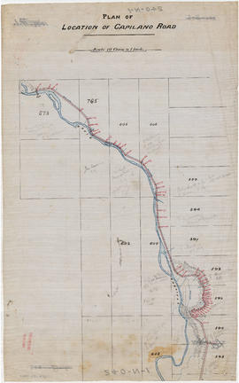
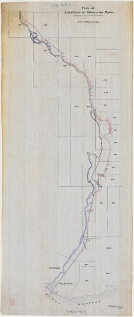
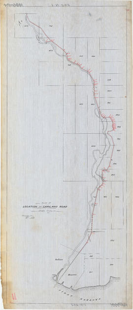
![Traverse of Capilano Road & pipe line through [District] Lot 594 NWD [New Westminster District]](/uploads/r/null/9/0/3/9037991f2486a9cd4c2d2940da69f422ccad131260700d83f81f8529152d8956/e01b3254-8711-47c6-a530-deb712555586-LEG1153_142.jpg)
![Plan shewing pipe line right of way through Lots 15, 16, 17, 18 & 19 D.L. [District Lot] 673 ...](/uploads/r/null/1/7/c/17c6697bdcbc4acaabcfbd2b60312b51d4b9e442fd113b9376cb994c4cdd707e/3d248d3a-3fca-431f-a491-972fea32373e-LEG1153_142.jpg)
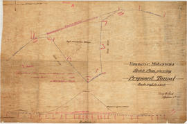
![Traverse of pipe line through [District] Lot 764. Made in 1890](/uploads/r/null/e/6/6/e6636344ea453438048b75977e8626a4c402efbe3a164905afded7318afb0e03/db967470-d758-412f-a944-85bc059a5995-LEG1153_142.jpg)