
Male Voice Choir of Nanaimo, B.C. Winners of the Eisteddfod Prize, Vancouver, May 22, 1912
- AM1519-: PAM 1912-57-: PAM 1912-57.2
- Part
- May 22, 1912
Part is a photograph. Group portrait of Male Voice Choir of Nanaimo, B.C.
239 results with digital objects Show results with digital objects
Male Voice Choir of Nanaimo, B.C. Winners of the Eisteddfod Prize, Vancouver, May 22, 1912
Part is a photograph. Group portrait of Male Voice Choir of Nanaimo, B.C.

An auction sale of government lands
Item is a poster announcing an auction sale of provincial government lands situated in the Municipality of Point Grey at Dominion Hall, 339 Pender Street West. The auction encompassed "the ten blocks known as Blocks 182, 193, 194, 205, 206, 217, 218, 229, 230 and 233 - District Lots 176 and 538." The ten blocks for sale are shown at the bottom of poster and the map shows they are located between Highbury Street and Alma Road, and 10th Avenue to Point Grey Road. Map in upper right corner of poster shows the City of Vancouver from 27th Avenue to 13th Street (North Vancouver), and Esmono Avenue to just past Tolmie Street.

Part shows a map of the City of Vancouver extending from Boundary Road to Burrard Inlet to Alma Street to King Edward. Lot numbers and street names are shown, along with ward lines, district lot lines street railway lines and railroad lines represented by a legend in the bottom left corner.
The Western Guide, index to map
Part contains an index to the map on the other side, including places of interest, hospitals, depots, streets, Vancouver car lines, and advertisements for Mission Studio and Union Steamship Co. of B.C. Limited.

Standard tourist's guide to Stanley Park : page 1
Part contains historical information and general information about visiting Stanley Park.

Standard tourist's guide to Stanley Park : Stanley Park, Vancouver, B.C., key plan
Part is a map showing points of interest in Stanley Park, including car lines, roads and car routes, buildings, beaches, and trails.

How to see Vancouver, Canada : side 1
Part is one side of pamphlet entitled "How to see Vancouver, Canada." Part contains suggestions for activities, trips and locations to visit, as well as two inset maps: "Street Map of Vancouver's Business District" and "Roads in Vancouver and District."

Standard tourist's guide to Stanley Park, a few facts about Vancouver : back cover
Part is the back cover of pamphlet and contains facts about the City of Vancouver.

Standard tourist's guide to Stanley Park : cover page
Part is the cover page for pamphlet about Stanley Park featuring a photo captioned: "Lily Pond and Band Stand at Refreshment Pavilion" taken by Gowen-Sutten & Co. Ltd.

Standard tourist's guide to Stanley Park : Index to points of interest
Part is the index to points of interest found on the Stanley Park map in pamphlet. Includes automobile routes, street car routes to park, viewpoints, gardens, and bodies of water.
How to see Vancouver, Canada : side 2
Part contains a day by day guide to visiting Vancouver for tourists and information on street car rides and routes.

Vancouver location map : side 1
Part is an illustrated map showing Vancouver streets and some buildings from English Bay to Burrard Inlet to Heatley Avenue to Granville Island. Map contains two inset photos of the Auto Camp at Hastings Park and the Suspension Bridge at Capilano Canyon with text.

Vancouver location map : side 2
Part contains advertisements for Vancouver retail shops, hotels, B.C.A.A., and restaurants and three inset maps. Maps show cities between Ashford, Washington and Vancouver, B.C., Union Steamship Company sea trips in Howe Sound, and recommended motor trips and routes around Vancouver.

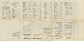
Indexed map of Greater Vancouver : side 2
Part contains a map of the Greater Vancouver area from Gulf of Georgia to Frederick Road to Craig Street to Lulu Island, accompanied by an index of street names.

Automobile road map of Vancouver Canada : side 1
Part contains textual information including points of interest, Canadian customs regulations, ferry timetables and rates. Part also contains two inset maps. A map of the Okanagan Circuit is in the top left corner, showing town names and a distance table with distances of towns from Vancouver in miles. A map showing ferry routes in the Gulf of Georgia is located in the middle of part.

Automobile road map of Vancouver Canada : side 2
Part contains a map showing major automobile roads extending from English Bay to The Lions to Clayburn to Blaine, Washington. Roads are shown in red. An inset map showing a continuation from Mission and Huntingdon to Harrison Hot Springs is located in top right corner of part.
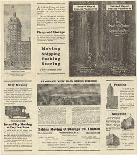
Indexed map of Greater Vancouver : side 1
Part contains advertisements for Bekin Moving and Storage Co. and the Bekin Building. Part contains illustrations of the Vancouver Depository, Seattle Depository and Portland Depository buildings, and an image of a panoramic view of the North Shore.

University Hill : the residential section of Greater Vancouver : side 1
Part contains a map showing properties, with lot numbers and prices, for sale from Westbrook Crescent to Chancellor Boulevard to Acadia Road to Toronto Road. A legend showing the zoning for each property accompanies the map.

University Hill : the residential section of Greater Vancouver : side 2
Part contains textual information about purchasing properties in University Hill including information about general terms, sites, building requirements and restrictions, taxes and charges, transportation, and loans. Part also includes four photographs showing views of the properties .

Westmount Park : the subdivision superb : side 2
Part contains information about purchasing lots in Westmount Park and is accompanied by two inset maps. One map shows the lots for sale from Blanca Street to Belmont Drive to Tolmie Street to Second Avenue, their numbers and a price list, the other map shows where Westmount Park is situated in Vancouver.

Tourists' map of Greater Vancouver : inside cover
Part consists of the inside cover of pamphlet containing information about David Spencer Limited.

Municipality of Point Grey second annual dinner of the staff of the engineering department

Westmount Park : the subdivision superb : side 1
Part is the cover page showing an illustration of the area of Westmount Park.

Part consists of a map of Greater Vancouver. Map extends from Howe Sound to Dome Mountain to Pitt River to Lulu Island. Map shows principal street names, golf and country clubs, bodies of water and city limits. Part contains textual information about parking regulations for the David Spencer store.

Tourists' map of Greater Vancouver : map of downtown Vancouver and map of New Westminster
Part contains a map of Downtown Vancouver, a map of the downtown section of New Westminster, and information for tourists including interesting facts about Vancouver. Maps show principal street names and some building names.

Tourists' map of Greater Vancouver : cover
Part contains the front and back covers of the pamphlet, a map of Downtown Vancouver, a map of the downtown section of New Westminster, and information for tourists, including interesting facts about Vancouver. Maps show principal street names and some building names.

Highways of Greater Vancouver British Columbia and the Fraser Valley : side 1
Part contains a map showing main thoroughfares and other streets in Downtown Vancouver. Part also includes tourist information on boat and ferry connections, motor drives, boat trips, fishing, hunting, recreation, and mileages from Vancouver to other destinations.

Highways of Greater Vancouver British Columbia and the Fraser Valley : side 2
Part contains a road map of the Fraser Valley extending from the Gulf of Georgia to Pitt Lake to Mount Cheam to Blaine, Washington. Legend on map shows main arterial roads, secondary roads, other roads, hiking trails, ferries and railways.


Sectional map and street directory of Vancouver, British Columbia : cover page

Sectional map and street directory of Vancouver, British Columbia : title page


Sectional map and street directory of Vancouver, British Columbia : map of Stanley Park


Sectional map and street directory of Vancouver, British Columbia : key map

Sectional map and street directory of Vancouver, British Columbia : introduction to map

