
Proposed underground convenience
- COV-S365---: LEG288.17
- Item
- [190-?]
Part of City of Vancouver fonds
Item is an architectural plan depicting the floor plan of an underground public restroom.
Doulton & Co.
8961 results with digital objects Show results with digital objects
Proposed underground convenience
Part of City of Vancouver fonds
Item is an architectural plan depicting the floor plan of an underground public restroom.
Doulton & Co.
![[Three horses pulling firefighting apparatus and firefighters down a downtown street]](/uploads/r/null/b/3/c/b3ce5cd50bd21590baa6bc034b2e2647852518c0c8a32ef29537fd2523e1e68f/277b5079-9fe5-47c5-baea-61e55464afec-CVA354-442_142.jpg)
[Three horses pulling firefighting apparatus and firefighters down a downtown street]
Part of City of Vancouver fonds

Plan of proposed underground convenience for Vancouver
Part of City of Vancouver fonds
Item is an architectural drawing depicting the plan for an underground public restroom. The drawing includes cross-sections. The drawing may have been used for reference purposes, or submitted to show supplied equipment associated with a design completed by the Engineering Department.
Walter Macfarlane & Co. Saracen Foundry
![[Cribbing on road at edge of Capilano Creek]](/uploads/r/null/a/3/a359362e8107f6a8feb33a5b82762ea3906af278d6f024af920dd189ce5d2593/ba3f6329-5973-4d12-96d2-90a0a3909935-A16597_142.jpg)
[Cribbing on road at edge of Capilano Creek]
Part of City of Vancouver fonds
Photograph shows what may be Capilano Hotel in background.
Bank of Ottawa / Bank of Nova Scotia building, 602 West Hastings Street
Part of City of Vancouver fonds
File consists of architectural drawings of the original design for and later alterations to the building. Drawings include plans, exterior and interior elevations, sections and details.
W. Marbury Somervell, Architect
![[Spectators watching fire at Cottrell Warehouse on Water Street]](/uploads/r/null/3/0/9/3092a926759f74050e7144432d95f5ab6598074bcdbad257618c04ae5d972b16/d305a1ef-4efd-4452-aa02-6e7f5c8d4762-CVA354-375_142.jpg)
[Spectators watching fire at Cottrell Warehouse on Water Street]
Part of City of Vancouver fonds
Part of City of Vancouver fonds
![[View of fire at G.H. Cottrell Warehouse, 139 Water Street]](/uploads/r/null/d/4/2/d42e9cc6d0ed113b820738761abee8e002b3343ece277b2d2aa63d56af341039/38d982ad-3791-47df-aa20-a24e3dff0244-CVA354-018_142.jpg)
[View of fire at G.H. Cottrell Warehouse, 139 Water Street]
Part of City of Vancouver fonds
Item is a photograph showing fire fighters climbing a ladder at building with hoses and engines below and spectators watching from below and from across the street at a rooming house.
![[View of fire at G.H. Cottrell Warehouse, 139 Water Street]](/uploads/r/null/7/7/f/77fd5ca731af55dd5a162210e373ed1c37da355870a390abd03fe0fad87f1f74/0933c3f9-6fcd-4e14-b6fd-5a5b74c03fa0-CVA354-019_142.jpg)
[View of fire at G.H. Cottrell Warehouse, 139 Water Street]
Part of City of Vancouver fonds
Item is a photograph showing the warehouse ablaze and firemen on a ladder. A crowd of spectators is visible in the foreground.
![[Spectators watching fire at Cottrell Warehouse on Water Street]](/uploads/r/null/a/7/6/a763747a287786a260e55968b2f9014adbbc5ef88d828cb7b701b10c10e0171d/237a9c1b-b8d3-4ad5-b50f-e02b4f4fdb2e-CVA354-374_142.jpg)
[Spectators watching fire at Cottrell Warehouse on Water Street]
Part of City of Vancouver fonds
Item is a photograph showing firefighters climbing a ladder to the burning building and a large mass of smoke surrounding the warehouse.
![[Coal Harbour view from Denman Street]](/uploads/r/null/f/4/f4ee6b5b8d147b8a774a97a7b59f6f8c29bb8792a52da1695f47dce307742555/f90773a4-4b21-478d-bd42-505e1d441b47-A16624_142.jpg)
[Coal Harbour view from Denman Street]
Part of City of Vancouver fonds
![[Firefighters and motorized equipment in front of Firehall No. 2, 754 Seymour Street]](/uploads/r/null/1/a/2/1a2f1373f1d648856294c4009aca38f93d121927679c379a3ab4dd4db0fd8128/e7169b57-02b8-4cc5-a5d8-122e1c212954-CVA354-043_142.jpg)
[Firefighters and motorized equipment in front of Firehall No. 2, 754 Seymour Street]
Part of City of Vancouver fonds

Part of City of Vancouver fonds
![[Spectators gathered at apartment fire]](/uploads/r/null/7/e/a/7eaf5dd372b990272c9120815a904008bf9e71ee23108ba12ad938200de8c6cd/4b1985fb-5e6c-4723-ab47-535da5b16817-CVA354-048_142.jpg)
[Spectators gathered at apartment fire]
Part of City of Vancouver fonds
![Abbot and Hastings oppo[site Hotel] Lotus](/uploads/r/null/9/1/91eb88a5795d43121cd684a78ce1425823c1e974aafcebadddc0137ff36d1490/af5dca7e-8b6a-4de7-9dfa-b219b0eb63c7-A16591_142.jpg)
Abbot and Hastings oppo[site Hotel] Lotus
Part of City of Vancouver fonds
![[Gathering of fire engines to show "Fully Motorized" occasion at C.P.R. freight yards]](/uploads/r/null/4/6/4/464e3333148bebd4439aa317794f2892018b4cdc4c4f2c3e8cfed544422a76d1/ac7aecd4-f952-4786-9697-0f24efacfc7c-CVA354-049_142.jpg)
[Gathering of fire engines to show "Fully Motorized" occasion at C.P.R. freight yards]
Part of City of Vancouver fonds
Item is a photograph showing firefighters and fire equipment with a view of the 700 block of Main Street and a rail car in the background.
![[View of aftermath of fire at Coughlin Shipyards - Fmn. (fireman) Cameron killed]](/uploads/r/null/0/9/4/09432532898fda03f4d03a2915beec43a56c9ffe28f335bee8a3b5e1edfbfa8a/19792784-df36-4eeb-abce-7fa1ec269cb2-CVA354-052_142.jpg)
[View of aftermath of fire at Coughlin Shipyards - Fmn. (fireman) Cameron killed]
Part of City of Vancouver fonds
![[Two members of South Vancouver Fire Department with Studebaker C.S.T. by roadside]](/uploads/r/null/1/3/6/1362dd0e360ddfb8f9c7a69209c447d517c18cc24d756999bbae068498c11e97/f4124cda-9e8c-4cda-abeb-77a5b2aed1df-CVA354-070_142.jpg)
[Two members of South Vancouver Fire Department with Studebaker C.S.T. by roadside]
Part of City of Vancouver fonds

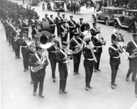
Vancouver Fire Department Band
Part of City of Vancouver fonds
Item is a photograph showing (L-R): Back row - J. Leatherdale, A. LeClair, A.E. Wilkins, L. Leavy, F.G. Luchs, J. Evans, C. Hodson, W. bets, B. Smethurst, R.G. Shaw, G. Harrod, T. Anderson. Middle row - A. King, J. Lyon, T. Warne, C.A. Hillier, A.H. Whipple, H. McElwaine, J. Travis, F. Jenkins, W. Middleton, E. Williamson. Front row - M. Pillat, M. McLeod, E.W. Barnett, G. Ford, M.K. McLennan, H. Ellis, C. Ross.
Part of City of Vancouver fonds
Part of City of Vancouver fonds

Part of City of Vancouver fonds

Part of City of Vancouver fonds
![[View of Canadian Pacific Railway Pier D on fire]](/uploads/r/null/9/4/7/947a23d02f7e0b571dc3ea2c42c87f331257cb8e07a77cd2fd080ee000a32c49/43728ece-6a42-442b-8400-3b359d07fb59-CVA354-104_142.jpg)
[View of Canadian Pacific Railway Pier D on fire]
Part of City of Vancouver fonds
![[View of water hoses pouring from Canadian Pacific Station to put out fire at Pier D]](/uploads/r/null/7/9/8/798551f471c491232032352018932010bf28801aaace12720a68ae77015cee00/43c11677-dbe1-47c4-a109-d4b5d811bcf2-CVA354-114_142.jpg)
[View of water hoses pouring from Canadian Pacific Station to put out fire at Pier D]
Part of City of Vancouver fonds
![[View of crowds and fire at Canadian Pacific Railway Pier]](/uploads/r/null/f/c/e/fce743c0128daed19583e4e82a84e7250c4ffcdf765162fe91e58f012f8c647e/6ca98ae0-43f7-410e-945d-da3f3113e69a-CVA354-102_142.jpg)
[View of crowds and fire at Canadian Pacific Railway Pier]
Part of City of Vancouver fonds
![[View from railyard showing the Canadian Pacific Railway Pier D on fire]](/uploads/r/null/9/8/8/98829d8436c7c34cbbc850a4885dbc536b678734e966552bcd71afa7bbb4dfcc/d9de056b-7fa1-4027-985b-46229ce11dc2-CVA354-113_142.jpg)
[View from railyard showing the Canadian Pacific Railway Pier D on fire]
Part of City of Vancouver fonds
![[View of smoke coming from Canadian Pacific Railway Pier D fire]](/uploads/r/null/8/0/f/80fbdecd3d0dd436ed1a409cbdff968552aab37e875d989befcf4e8652c5832b/521043dc-d66d-42f4-98f0-cbe6e7b33ca6-CVA354-117_142.jpg)
[View of smoke coming from Canadian Pacific Railway Pier D fire]
Part of City of Vancouver fonds
![[View of crowds and fire at Canadian Pacific Railway Pier]](/uploads/r/null/2/6/f/26f3a514804e9213c0c6072bbb41069ff8a1aca41deb60e7231722782014fe45/f4952a18-2862-46ac-93bc-a1577784c3e3-CVA354-103_142.jpg)
[View of crowds and fire at Canadian Pacific Railway Pier]
Part of City of Vancouver fonds

Part of City of Vancouver fonds
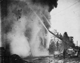
![[Firefighters hosing down blaze at United Grain Growers' storage bins]](/uploads/r/null/d/f/b/dfb7b6ca36ae24881230496fe7ff3c46300329cdda29b21227512b720f8f7384/ed4b9802-694f-4c31-b99d-6f1e8528d532-CVA354-397_142.jpg)
[Firefighters hosing down blaze at United Grain Growers' storage bins]
Part of City of Vancouver fonds

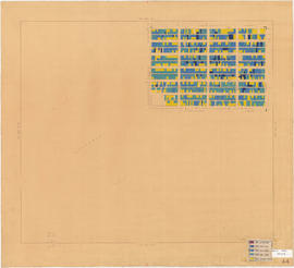
Age of buildings : Main Street to Clark Drive and Prior Street/Venables Street to Broadway
Part of City of Vancouver fonds
Sheet is annotated to show the boundary of Area 'H' for the Vancouver Redevelopment Study.

Age of buildings : Arbutus Street to Oak Street and Odgen Avenue to Broadway
Part of City of Vancouver fonds

Age of buildings : Slocan Street to Boundary Road and 5th Avenue to 22nd Avenue
Part of City of Vancouver fonds
Part of City of Vancouver fonds

Age of buildings : Crown Street to Blenheim Street and 41st Avenue to 55th Avenue
Part of City of Vancouver fonds
Age of buildings : Blanca Street to Discovery Street and 10th Avenue to 16th Avenue
Part of City of Vancouver fonds
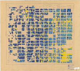
Age of buildings : Clark Drive to Slocan Street and Hastings Street to 6th Avenue
Part of City of Vancouver fonds

Part of City of Vancouver fonds

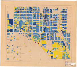
Age of buildings : Clark Drive to Slocan Street and Powell Street/Wall Street to Hastings Street
Part of City of Vancouver fonds

Age of buildings : Knight Street to Slocan Street/Wales Street and 22nd Avenue to 37th Avenue
Part of City of Vancouver fonds
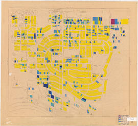
![Age of buildings : Slocan Street to Boundary Road and Wall Street/East Street [Edinburgh Street] ...](/uploads/r/null/e/9/2/e921e2151aed2f9a2fd506bbc7e781632de17633f5f2f1a410764a15e68501b4/01454f17-8dfb-417d-9fd9-0093f19fcd56-LEG1221_142.jpg)
Part of City of Vancouver fonds

Age of buildings : Oak Street to Main Street and Broadway to King Edward Avenue
Part of City of Vancouver fonds

Age of buildings : Arbutus Street/S.W. Marine Drive to Fremlin Street and 57th Avenue to 72nd Avenue
Part of City of Vancouver fonds

Age of buildings : Blenheim Street to Arbutus Street and Broadway to King Edward Avenue
Part of City of Vancouver fonds
Age of buildings : Blenheim Street to Maple Street/Laburnum Street and 41st Avenue to 57th Avenue
Part of City of Vancouver fonds

Age of buildings : Slocan Street to Boundary Road and 22nd Avenue to Kingsway
Part of City of Vancouver fonds
Age of buildings : Oak Street to Main Street and King Edward Avenue to 41st Avenue
Part of City of Vancouver fonds
Age of buildings : Knight Street to Elliott Street and 53rd Avenue to Kent Avenue
Part of City of Vancouver fonds

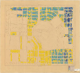
Age of buildings : Jellicoe Street to Boundary Road and S.E. Marine Drive to Kent Avenue
Part of City of Vancouver fonds
Annotations show date of construction of buildings for the area bounded by Jellicoe Street, Boundary Road, S.E. Marine Drive, and Kent Avenue. Base map shows the area bounded by Jellicoe Street/Fraserview Golf Course, Boundary Road, 61st Avenue, and the North Arm of the Fraser River.