[Sechelt Peninsula and surrounding coastlines and islands]
- AM738-S1-: 1980-253.47
- Item
- [ca. 1911]
Item shows land surveyed lots.
63 results with digital objects Show results with digital objects
[Sechelt Peninsula and surrounding coastlines and islands]
Item shows land surveyed lots.
Map of Port Moody and vicinity
Item shows roads and legal descriptions, soundings, harbour, and railway.

Item is a map showing district lot, block, and lot numbers, and both current and former street names.
Series documents the production of maps by Dominion Map Limited through maps in both draft and published form, as well as, maps by other map-making companies used as reference materials sometimes with annotations by Dominion Map Limited.
Dominion Map and Blueprint Company fonds
Fonds illustrates six decades of map production by Dominion Map Limited.
Dominion Map Limited (Vancouver, B.C.)
![Part of D.L. [District Lot] 185](/uploads/r/null/d/0/2/d020a729408b2c6caa3fc78d706b687230bf429554ef426ba4dc104ce23d48d6/dbf9611e-8fed-4827-b82a-7e29f4922fc3-MAP904_142.jpg)
Part of D.L. [District Lot] 185
Item is section 4 of a City of Vancouver Surveys Branch sectional plan of Vancouver. Item shows area bounded by Nicola Street to Burrard Street and Nelson Street to False Creek.
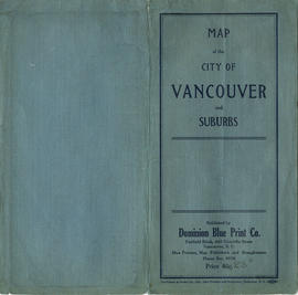
Map of the City of Vancouver and suburbs : map cover
Map shows boundaries, lot numbers and major roads in Greater Vancouver (including West Vancouver, North Vancouver, the City of North Vancouver, the City of Vancouver, Coquitlam, Point Grey, South Vancouver, Burnaby, New Westminster, Port Moody, Port Coquitlam, Pitt Meadows, Surrey, Langley, Delta and Richmond).

Map shows boundaries, lot numbers and major roads in Greater Vancouver (including West Vancouver, North Vancouver, the City of North Vancouver, the City of Vancouver, Coquitlam, Point Grey, South Vancouver, Burnaby, New Westminster, Port Moody, Port Coquitlam, Pitt Meadows, Surrey, Langley, Delta and Richmond).
General key plan to the insurance volumes of municipality of Burnaby

Item is a map showing wards, district lots, streetcar lines, railways, and names of businesses occupying waterfront sites on False Creek and Burrard Inlet.

Map of Granville Street, downtown Vancouver
Item is a map showing Granville Street from the Granville Street Bridge over False Creek in the southwest to the train yard and waterfront below Cordova Street in the northeast. Numbered city blocks on either side of the street are depicted, with numbers and occupants' names (including businesses) shown for most of the properties. The location of the publisher's office on Seymour Street is shown.

Map of City of Vancouver, British Columbia
Map shows streets, schools, hospitals, street car lines, railways and address block numbers in Vancouver.
Index map of the British Columbia Coast with steamship routes
Item shows routes and ports of call of the Canadian Pacific railway Company, the Union Steamship Company, and the Grand Trunk Steamship Company; including lists and locations of logging camps.
Map of city of Vancouver, British Columbia
Map shows streets, schools, hospitals, street car lines, railways and block numbers in the city of Vancouver. Street index on verso.


Map of Fraser Valley, British Columbia
Item is a map showing trunk roads, main and local roads, and railway lines.

Item is a map of the Fraser Valley from Vancouver to Chilliwack showing roads, railway lines, schools, churches, and post offices.
Indexed map and guide of the British Columbia coast
Item is a map of the B.C. coast, including inset maps of the Gulf Islands and the lower mainland.
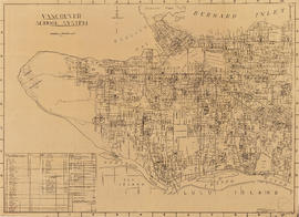
Item is a copy of a City of Vancouver Planning Department map showing the locations of schools in Vancouver's public school system.
Notes, memorandums, and articles
File consists of memos for production orders, notes, and reference material.
Series documents the development of street directories for the Vancouver area and the Fraser Valley. Also included are memos for production orders, notes and reference material.
Item is a sectional map of Vancouver from Quebec Street to Clark Street between Keefer Street and Great Northern Way.
Item is a sectional map of Vancouver from Keefer Street to Burrard Inlet between Carrall Street and Clark Drive.
Item consists of a sectional map of Vancouver from Great Northern Way to East 16th Avenue between Ontario Street and Clark Street.
Map of Vancouver, B.C. City by the sea
Item is the original design for a tourist map of the Lower Mainland east to North Road and the North Shore. The map shows transportation, locations of sights, recreational facilities, etc.
Dominion Map Limited (Vancouver, B.C.)
Five regional British Columbia maps
Part is a sheet with five road maps showing routes on Vancouver Island, routes from Vancouver to Prince George, routes in the Okanagan, routes between Nelson, Revelstoke and Calgary and routes between Vancouver and San Francisco.
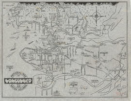
Pictorial map of Vancouver, British Columbia, city by the sea
Item is a pictorial map showing major roads and attractions in Vancouver, West Vancouver, North Vancouver, Burnaby, New Westminster, Sea Island and the northern portion of Lulu Island.
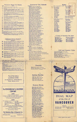
Part is a map of the City of Vancouver showing block numbers, street car lines and numbers, fire halls, hospitals, electric and steam railways and bus routes. The map includes a 'dial', and associated street index used to find locations.
Dial-map, City of Vancouver, British Columbia
Item is a two-sided road map, originally folded and housed in a cover.
Dial-map, City of Vancouver, British Columbia
Part is the outer cover into which the attached map was folded. Cover includes general information on Vancouver and public institutions in the city.
Sectional map and street directory of Vancouver : Dial map of the city of Vancouver
Item is a street map of Vancouver with map on one side and information on street car and bus routes, schools, businesses, and other notable locations on the other.
Information on transit and buildings in Vancouver
Part is the text side of a street map of Vancouver. Part also includes text advertisitng the products and services of the Dominion Map and Blueprint Company.


Part consists of a street map of Vancouver showing block numbers, street car, bus, and railway lines, parks and hospitals. Map includes a dial (a numbered circle, a paper indicator, a grid of block numbers and a street index used to find locations).
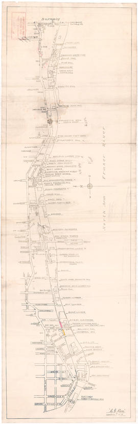
Businesses along the north shore of the North Arm of the Fraser River
Item is a map showing the locations and names of businesses located along the north shore of the North Arm of the Fraser River.
Ross, C.E.
Item consists of a sectional map of Vancouver from English Bay to West 3rd Avenue between Trutch Street and Maple Street.
Street map of the Fraser Valley
Item is a street map of the Lower Mainland and Fraser Valley from Vancouver to Chilliwack.
[Sheets : 1945 sectional map atlas of Vancouver]
File consists of copies of five sheets from the Vancouver 1945 sectional map atlas.
Sheet 19 : Kits Point - Davie Village
Item consists of a sectional map of Vancouver showing Kits Point from Maple to Granville Street including Vanier Park and Granville Island. Map also shows Davie Village between Bute Street and Homer Street.
Sheet 17 : Kitsilano - Greektown
Item consists of a sectional map of Vancouver from West 3rd Avenue and West 16th Avenue between Trutch Street and Maple Street.

Map shows a street plan in Vancouver according to the following: major streets of sufficient width, major streets to be widened, new major street connections, proposed express highways, scenic drives, boulevard drives, parkways and proposed major streets in the University Endowment Lands. The map also indicates the number of traffic lanes in each street.
Item is a site plan for the R.C.A.F site at Jericho Beach from English Bay in the north to 8th Avenue in the south and from Highbury in the east to Trimble in the west. The map contains a number of annotations (in red).
Canada. Department of National Defence
Wrigley's new revised map of Vancouver
Item is a street map of Vancouver, with a street index on the verso.