
Tidal current chart, Vancouver Harbour : one hour before maximum flood at First Narrows
- AM1594-: MAP 1179-: LEG1348.20
- Part
- Feb. 1952
Part of City of Vancouver Archives technical and cartographic drawing collection
246 results with digital objects Show results with digital objects
Tidal current chart, Vancouver Harbour : one hour before maximum flood at First Narrows
Part of City of Vancouver Archives technical and cartographic drawing collection

Tidal current chart, Vancouver Harbour : one hour after maximum flood at First Narrows
Part of City of Vancouver Archives technical and cartographic drawing collection

Tidal current chart, Vancouver Harbour : two hours after maximum flood at First Narrows
Part of City of Vancouver Archives technical and cartographic drawing collection

Tidal current chart, Vancouver Harbour : inside back cover
Part of City of Vancouver Archives technical and cartographic drawing collection
Part contains information about the survey data upon which the charts are based, and contact information for the Canadian Hydrographic Service.

Champlain Heights : D.L. 334, group one, N.W.D.
Part of City of Vancouver Archives technical and cartographic drawing collection
Part is a map showing lot numbers, lot sizes, lot values and sidewalk crossings in the area from Rosemont Drive in the north to 63rd Avenue in the south and from Butler Street in the east to Kerr Street in the west.

Greater Vancouver road map : map cover
Part of City of Vancouver Archives technical and cartographic drawing collection

Bus routes, city of Vancouver, November 26th 1937
Part of City of Vancouver Archives technical and cartographic drawing collection
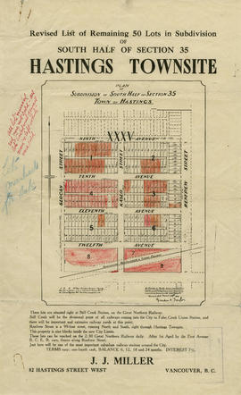
Revised list of remaining 50 lots in subdivision of south half of section 35, Hastings Townsite
Part of City of Vancouver Archives technical and cartographic drawing collection
Part contains a map showing lots for sale in the area bounded by Slocan Street, Renfrew Street, 9th Avenue, and 13th Avenue, and textual information for potential buyers. Annotations indicate which lots were sold.

Insurance plan of Port Coquitlam : key plan and sheet 1
Part of City of Vancouver Archives technical and cartographic drawing collection
Part contains the key plan for the insurance plan of Port Coquitlam, an inset map of the area bounded by Shaughnessy Street, Central Avenue, and Rindall Avenue, and a section of the insurance plan covering Dewdney Trunk Road where it crosses the Coquitlam River. Map shows legal descriptions, street widths, building dimensions and types (dwelling, office, industrial, other commercial use), names of businesses, and other features of the built environment relevant to insurance claims.

Insurance Plan of Port Coquitlam : sheet 4
Part of City of Vancouver Archives technical and cartographic drawing collection
Part contains a section of the insurance plan covering the area bounded by Chester Street, Cambridge Street, Grant Avenue, and Suffolk Avenue. Map shows legal descriptions, street widths, building dimensions and types (dwelling, office, industrial, other commercial use), names of businesses, and other features of the built environment relevant to insurance claims.

Information concerning the City and District of New Westminster and the Province of British Columbia
Part of City of Vancouver Archives technical and cartographic drawing collection
Part is the text side of a pamphlet. This part contains information concerning the city and district of New Westminster, with individual panels on the municipalities of Delta, Chilliwhack [sic], Surrey, Langley, and Delta, and the City of New Westminster, the town of Harrison Hot Springs and the province.
Map and guide to Vancouver street car and interurban lines
Part of City of Vancouver Archives technical and cartographic drawing collection
Part consists of the front page of a brochure, listing the various streetcar and interurban rail lines, and routes to points of interest in Vancouver.

Vancouver city and suburban lines
Part of City of Vancouver Archives technical and cartographic drawing collection
Part consists of a map of streetcar and interurban rail lines in Vancouver.
![Hastings Townsite [Boundary Road to 5th Avenue to Kamloops Street (?) to 33rd Avenue]](/uploads/r/null/7/f/0/7f0fe2a27b9af4f20ad7837792af3bbb3aa93c3487024e69b14fa38144134f19/8e7a0e66-c6cc-40ca-bbac-4ea73db77437-LEG1800_142.jpg)
Hastings Townsite [Boundary Road to 5th Avenue to Kamloops Street (?) to 33rd Avenue]
Part of City of Vancouver Archives technical and cartographic drawing collection
Part consists of a portion of the map, depicting the area approximately bounded by Boundary Road, 5th Avenue, Kamloops Street (?) and 33rd Avenue.

Map and guide to Vancouver street car and interurban lines
Part of City of Vancouver Archives technical and cartographic drawing collection
Part consists of the front page of a brochure, listing the various streetcar and interurban rail lines, and routes to points of interest in Vancouver.

Part of City of Vancouver Archives technical and cartographic drawing collection
Part contains street maps of the University Endowment Lands, Surrey, Maillardville, Lulu Island and Sea Island, tourist information about Vancouver, and text advertising the products and services of the Dominion Map and Blueprint Company.

Map of downtown section of Vancouver ; Diagram of New Westminster, B.C., downtown section
Part of City of Vancouver Archives technical and cartographic drawing collection
Part contains road maps of downtown Vancouver and New Westminster, and textual information for tourists and motorists.

Automobile road map of Greater Vancouver and environs : map cover
Part of City of Vancouver Archives technical and cartographic drawing collection
Map cover includes advertisements for Eng Chow Company and Happyland.

Part of City of Vancouver Archives technical and cartographic drawing collection

Part of City of Vancouver Archives technical and cartographic drawing collection
![Vancouver, B.C., the Pacific coast terminus of the C.P.R. [Canadian Pacific Railway]](/uploads/r/null/8/3/f/83fcf65f0d66d64e6357d0d647e0ea6e2fa4aae4c3d1919f952d7725b4299cda/623e750c-fbab-43b7-a496-d20b384baeb6-LEG1321_142.jpg)
Vancouver, B.C., the Pacific coast terminus of the C.P.R. [Canadian Pacific Railway]
Part of City of Vancouver Archives technical and cartographic drawing collection
Part contains text and engravings describing Vancouver's climate, resources, industries, and buildings. Cover page is stamped "Arthur McMullen."

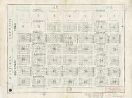
Hastings Townsite : Renfrew Street to Rupert Street and 5th Avenue to 13th Avenue
Part of City of Vancouver Archives technical and cartographic drawing collection
Part is a sheet of a sectional map of Hastings Townsite showing streets, railways, legal addresses, some lot sizes, and municipal boundaries. Item has been annotated with information regarding property ownership, including identification of properties included in a 1919 tax sale, and various symbols of unspecified meaning.

Hastings Townsite : Rupert Street to Boundary Road and 5th Avenue to 13th Avenue
Part of City of Vancouver Archives technical and cartographic drawing collection
Part is a sheet of a sectional map of Hastings Townsite showing streets, railways, legal addresses, some lot sizes, and municipal boundaries. Item has been annotated with information regarding property ownership, including identification of properties included in a 1919 tax sale, and various symbols of unspecified meaning.

Part of City of Vancouver Archives technical and cartographic drawing collection
Part is a sheet of a sectional map of Hastings Townsite showing streets, railways, legal addresses, some lot sizes, and municipal boundaries. Item has been annotated with information regarding property ownership and various symbols of unspecified meaning.

Part of City of Vancouver Archives technical and cartographic drawing collection
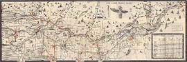
Part depicts the upper left hand quadrant of the map, and includes a diagram of the solar system, a table of dimensions of bodies in the solar system, a chart of constellations viewable in the northern hemisphere, text on geographical definiations and the cause of the tides, and a map of the northern half of the Americas.
Dunn, Samuel
Part of City of Vancouver Archives technical and cartographic drawing collection
Part is the top left hand quadrant of a map of the Americas, and depicts North America and the north-west portion of South America. The sheet also includes a list of territories and islands in North America and appears to relate to territorial divisions as a result of the Treaty of Paris and the Treaty of Versailles (1783).
![Howe Sound - Burrard Inlet [Howe Sound portion]](/uploads/r/null/7/a/1/7a1896077ddc37a7e16ac2d7e42a66031e13e11a9d966c43fca06cbb56f8bd96/5edd8d92-d3cd-4663-8fdd-996b3ae7a402-MAP30a_142.jpg)
Howe Sound - Burrard Inlet [Howe Sound portion]
Part of City of Vancouver Archives technical and cartographic drawing collection
Part shows the Lower Mainland and Howe Sound from Britannia Beach in the northwest to Indian Arm in the southeast. Map shows topographic contour lines, elevations, lakes, streams and other natural features, roads, railways, communication lines, cities and other settlements, and land, timber, and mineral surveys by number.
![Howe Sound - Burrard Inlet [Burrard Inlet portion]](/uploads/r/null/f/8/5/f8523992bb5d5e0c1391f2dea183041a54a2d2470eb4047bb29958a0d835ae95/fdf9563d-923e-468a-a494-3ff190294b91-MAP30b_142.jpg)
Howe Sound - Burrard Inlet [Burrard Inlet portion]
Part of City of Vancouver Archives technical and cartographic drawing collection
Part shows the Lower Mainland and Burrard Inlet from Howe Sound in the west to Indian Arm in the east. Map shows topographic contour lines, elevations, lakes, streams and other natural features, roads, railways, communication lines, cities and other settlements, and land, timber, and mineral surveys by number. Includes a list of sources of information.

Vest pocket map of Vancouver : map A
Part of City of Vancouver Archives technical and cartographic drawing collection
Part contains a key plan for the larger maps, textual information about Vancouver, and a map of the West End and downtown Vancouver.

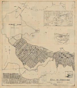
Indexed guide map of the city of Vancouver and suburbs
Part of City of Vancouver Archives technical and cartographic drawing collection
Part is a map showing district lots, blocks, and boundaries between the City of Vancouver, Point Grey, South Vancouver, Burnaby, New Westminster, and parts of Richmond, North Vancouver and West Vancouver. Concentric circles indicate the distance in miles from the intersection of Main Street and Hastings Street in intervals of 1/2 mile.

Indexed guide map of the city of Vancouver and suburbs : map booklet front cover
Part of City of Vancouver Archives technical and cartographic drawing collection

Part of City of Vancouver Archives technical and cartographic drawing collection
Part is a page from the booklet accompanying a guide map of Greater Vancouver, and contains a list of hotels in Vancouver.

Street index (Royal Oak Avenue, Vancouver to Frederick Road, North Vancouver)
Part of City of Vancouver Archives technical and cartographic drawing collection
Part contains two pages from the booklet accompanying a guide map of Greater Vancouver. Pages include the last portion of the Vancouver and Burnaby street index, the New Westminster street index, and the North Vancouver street index from 1st Street to Frederick Road.
Part of City of Vancouver Archives technical and cartographic drawing collection
Item is a sheet with a photograph of the federal Parliament buildings in Ottawa, and biographical sketches of Governors General and Prime Ministers of Canada, as well as of present provincial Lieutenants Governor; a list of Governors General and Prime Min
World maps and heads of government
Part of City of Vancouver Archives technical and cartographic drawing collection
Item is a sheet with a map of the world and a political and physical map of the Panama Canal Zone; these are surrounded by photographic portraits of twenty-fours heads of state, Roald Amundsen and Robert E. Peary.

A few facts about the north Fraser River
Part of City of Vancouver Archives technical and cartographic drawing collection
Part is a sheet of promtional-type information regarding economic activity in the municpalities bordering the north arm of the Fraser River. It lists nineteen companies operating along the north arm, with information on their capitalisation, turnover, profits, number of employees, etc.

Part of City of Vancouver Archives technical and cartographic drawing collection
Part is the cover and back page of a pamphlet. The back page is an index map of the province, showing the area covered by the main map on the interior (verso) sheet of the pamphlet.

Part of City of Vancouver Archives technical and cartographic drawing collection
B.C. Electric guide to Greater Vancouver
Part of City of Vancouver Archives technical and cartographic drawing collection
Part is the front side of a folded brochure containing information on the BC Electric transit system in Vancouver. This side includes route maps of services in Downtown Vancouver, central New Westminster, and Richmond. This side also includes a street ind
Greater Vancouver recreation sites and parks
Part of City of Vancouver Archives technical and cartographic drawing collection
Part is the inner side of the cover in which the attached map was folded. The page includes lists of various types of recreational sites and parks in Vancouver, Burnaby, New Westminster, North Vancouver and West Vancouver.

Vancouver, British Columbia, Canada
Part of City of Vancouver Archives technical and cartographic drawing collection
Part is a pictorial map noting the locations of main tourist sites described on the other side of the sheet. The sheet includes an index of points of special interest.
Bloodgood, Don

Part of City of Vancouver Archives technical and cartographic drawing collection
Part contains information on Delta, Chilliwhack [sic], Surrey, New Westminster, Maple Ridge, Langley, and British Columbia.
Transit system map of Greater Vancouver
Part of City of Vancouver Archives technical and cartographic drawing collection
Part is a map showing the routes of various BC Electric transit services. The inset map shows the Forest Hills/Canyon Heights area. The map also includes a guide to Vancouver street numbers.
Part of City of Vancouver Archives technical and cartographic drawing collection
Part is a map of the greater Vancouver area, showing communities across the region, with pictographs representing various communities. The map also includes a mileage table showing driving distances between various communities in Greater Vancouver.
British Columbia. Travel Bureau

City of Vancouver : Canadian Pacific town site
Part of City of Vancouver Archives technical and cartographic drawing collection
Part contains four maps. The main map shows district lots and block numbers in Vancouver from Vine Street in the west to Boundary Avenue (Glen Drive) in the east and Stanley Park in the north to 9th Avenue (Broadway) in the south. Three smaller maps include an index plan to district lots in Vancouver, South Vancouver, New Westminster, and Burnaby; a world map showing Canadian Pacific mail steamship lines; and an index plan of Vancouver city limits. Part has been annotated with text describing a June 1888 land clearance plan and hand colouring indicating clearance status.

Vancouver, B.C., Pacific terminus of the C.P.R.
Part of City of Vancouver Archives technical and cartographic drawing collection
Part is the front page of an unfoldedd brochure. The text describes Vancouver's growth and prospects for the future. Illustrations of different buildings in Vancouver and some parks are also shown.
Ross and Ceperley (Vancouver, B.C.)
City of Vancouver. Canadian Pacific town site
Part of City of Vancouver Archives technical and cartographic drawing collection
Part is a map sheet with one principal map, three inset maps and one illustration. The main map is a copy of a L.A. Hamilton map of downtown Vancouver and the land surrounding False Creek. Textual information is provided about the history and layout of Stanley Park. Inset maps show the Canadian Pacific mail steamships lines around the world and an index plan of Vancouver, B.C.
Part of City of Vancouver Archives technical and cartographic drawing collection
Part is a map of District Lot 69, showing blocks and lots in blocks 12 to 49.

Part of City of Vancouver Archives technical and cartographic drawing collection
Part is the inner sheet of an unfolded brochure, showing lots offered for sale in the northern portion of District Lot 540.