Contour plan of a portion of the City of Vancouver
Water service map of South Vancouver : Bridge Street (Cambie Street) to Main Street and 16th Avenue to 26th Avenue
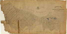
Water service map of South Vancouver : Fraser Street to Knight Street and 25th Avenue to 34th Avenue (33rd Avenue)
Water service map of South Vancouver : Churchill Street (Rupert Street) to Tyne Street and School Road (School Avenue) to 46th Avenue (45th Avenue)
Water service map of South Vancouver : Tyne Street to Park Street (Boundary Road) and Vanness Avenue to 46th Avenue (45th Avenue)
Water service map of South Vancouver : Ontario Street to Fraser Street and 33rd Avenue to 41st Avenue
Water service map of South Vancouver : Tyne Street to Park Street (Boundary Road) and 46th Avenue (45th Avenue) to 56th Avenue (54th Avenue)
Water service map of South Vancouver : Victoria Drive to Vivan Street and 67th Avenue (65th Avenue) to North Arm of Fraser River
Water service map of South Vancouver : Doman Street to Park Street (Boundary Road) and 67th Avenue (65th Avenue) to North Arm of Fraser River
Hong Kong and Victoria -miscellaneous
Sheet 20 : Granville Street to Ontario Street and Robson Street to Sixth Avenue
Sheet 15 : Ash Street to St. George Street and Fifty-eighth Avenue to Marine Drive
Sheet 16 : St. George Street to Argyle Street and Fifty-eighth Avenue to Fraser River
Sheet 2 : Slocan Street to Boundary Road and Charles Street to Triumph Street
Sheet 1 : Slocan Street to Boundary Road and Triumph Street to Burrard Inlet
Sheet 23 : Stanley Park to Granville Street and Robson Street to False Creek
Sheet A : University Endowment Lands to Imperial Street and waterfront to Fifth Avenue
Sheet F : Wallace Street to Trafalgar Street and Sixteenth Avenue to Twenty-seventh Avenue
Sheet H : Alexandra Street to Cambie Street and Fifteenth Avenue to Twenty-seventh Avenue
Sheet J : University Endowment Lands to Wallace Street and Twenty-ninth Avenue to Thirty-eighth Avenue
Sheet W : Fraser River to French Street and Fifty-ninth Avenue to Seventy-first Avenue
Sheet 4 : Prince Edward Street to Bruce Street and King Edward Avenue to Thirty-sixth Avenue
Sheet 10 : Earles Street to Boundary Road and Fortieth Avenue to Fiftieth Avenue
400 Block East Georgia across McLean Park
Intersection of Georgia and Dunlevy, looking north-west from roof of high-rise
View of Strathcona, McLean Park housing development in foreground
700 Block East Georgia, looking west
New McLean park in foreground, 700 block Keefer in background
Relocation of Raymur Avenue
Area A-2 [Looking north-west. from 1000 Block Union Street]
[1908 Amoskeag self-propelled steamer with firefighters on street at No. 1 Firehall]
[Deputy Chief C.W. Thompson at wheel of automobile in front of house, location unknown]
[View of funeral procession for Fireman Herbert E. Ellis, mortally injured on April 17, 1938. Funeral procession from Christ Church Cathedral with Firemen's Band]
[Firefighters battling blaze at Passlin Hotel, 700 block Richards Street]
King Edward Avenue (25th)
East 40th Avenue, looking west (Main to Ontario), London Plane
East 42nd Avenue, looking northwest (Main to Ontario), London Plane
East 43rd Avenue, looking west (Main to Ontario), Horse Chestnut
Ontario Street and West 46th Avenue, looking North Catalpa and Cedar on west side
Ontario Street and West 45th Avenue, looking south - Cedar (same trees as frame 8A)
Almond Park, West 13th Avenue, street end
B.C. EL - R.O.W. (British Columbia Electric Railway Right-of-Way)
B.C. EL - R.O.W. (British Columbia Electric Railway Right-of-Way)


![Area A-2 [Looking north-west. from 1000 Block Union Street]](/uploads/r/null/1/8/c/18c52e9c6ad49618ad4970e1d4e3577ab59b064154b43a899ad4a2e76673fbc7/741daa67-a4fa-4c43-9c8d-f215ae9de615-CVA181-32_142.jpg)
![[1908 Amoskeag self-propelled steamer with firefighters on street at No. 1 Firehall]](/uploads/r/null/1/3/5/13521aa9822ab0621dd174314ab0da79b3c9464050100ca355b44e2981514ca5/c293057e-0626-45c0-900a-16d6af894027-CVA354-038_142.jpg)
![[Deputy Chief C.W. Thompson at wheel of automobile in front of house, location unknown]](/uploads/r/null/0/7/9/079e0aa56e8021afe42cffa066588b8247abfa2d6241e7fa304e3bba3787c957/9464de60-42fe-4f1c-a30c-109c825dc061-CVA354-054_142.jpg)

![[Firefighters battling blaze at Passlin Hotel, 700 block Richards Street]](/uploads/r/null/5/6/4/5641b5fabc7f3acc6ed04ff5a4536e05e046766e1f840678824809879ab02ac7/4cadeaf9-8ebe-4b5b-97b1-6e7b9af8a59f-CVA354-262_142.jpg)


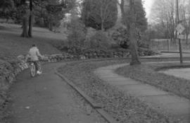

![Walks [2 of 3]](/uploads/r/null/1/e/1e83f91f6ef81f3820c37864fc9e84e53810be41cd4afe2e105d5e04254df8da/46a44585-1c9c-418e-8ae3-9e067cab679d-A64110_142.jpg)
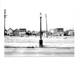
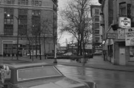
![Streets [2 of 139]](/uploads/r/null/6/9/691f5428eb0d996cc54bb5b3f09b24bf233cbf58710438a6fef12f18e55aaacd/753597c6-33be-41a0-a531-46cd27b9d2c6-A64143_142.jpg)
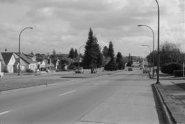
![Streets [7 of 139]](/uploads/r/null/4/6/46133e3d7b0e678679bd03b38d6235ff74fcde55411a6cb692d3ec33a9ebf924/8304b75f-82b9-4441-ad87-b1e39b4698d8-A64169_142.jpg)
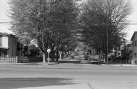
![Streets [10 of 139]](/uploads/r/null/0/a/0ae4e35b96275ac70ee0c6fa3893aa168313f1be5c398df03112417ee3c58a0e/ea2e8b04-28c6-4c94-81e3-3f36e8b0a203-A64172_142.jpg)
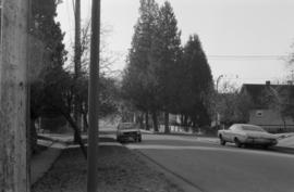
![Streets [26 of 139]](/uploads/r/null/7/9/79170d39ecb86119b7f7c6ff61073159f531e9c9714e360c4031135e2a2d36c9/2de4f1c0-9fbc-4ef3-8bb7-d282ea347360-A64214_142.jpg)
![Streets [41 of 139]](/uploads/r/null/3/9/3927d98e7df929d4a9c48086401cce50129f1df5d06229ee78f4cea497e6d3fa/e2582502-f515-482e-a99c-0c69ef9ecf5f-A64229_142.jpg)
![Streets [55 of 139]](/uploads/r/null/4/4/449f33ab49aa27b49bf044a3bd2379a27aec3168da46d5801380256d1ebd8270/3c2c710f-af52-48b5-ab13-b64929987ab1-A64243_142.jpg)