Sheet 10 : Clark Drive to Slocan Street and waterfront to Triumph Street
Sheet 19 : Maple Street to Richards Street and Drake Street to Third Avenue
Sheet 16 : St. George Street to Argyle Street and Fifty-eighth Avenue to Fraser River
Sheet A : University Endowment Lands to Imperial Street and waterfront to Fifth Avenue
Sheet G : Trafalgar Street to Granville Street and Sixteenth Avenue to Nanton Avenue
Sheet H : Alexandra Street to Cambie Street and Fifteenth Avenue to Twenty-seventh Avenue
Sheet L : Trafalgar Street to Granville Street and Nanton Avenue to Thirty-eighth Avenue
Sheet O : Holland Street to Elm Street and Thirty-eighth Avenue to Forty-ninth Avenue
Sheet P : Trafalgar Street to Granville Street and Thirty-ninth Avenue to Thirty-seventh Street
Sheet X : Marine Drive to Ash Street and Fifty-ninth Avenue to Seventy-first Avenue
Sheet S.V. 3 : Cambie Street to St. George Street and Twenty-seventh Avenue to Thirty-eighth Avenue
Sheet 5 : Dumfries Street to Fairmont Street and Twenty-seventh Avenue to Thirty-seventh Avenue
Sheet 8 : Prince Edward Street to Bruce Street and Thirty-fifth Avenue to Forty-seventh Avenue
Sheet 10 : Carlton Street to Boundary Road and Fortieth Avenue to Fiftieth Avenue
Sheet 6 : Knight Street to Slocan Street and Eighteenth Avenue to Twenty-ninth Avenue
Sheet 9 : Clark Drive to Slocan Street and Triumph Street to Charles Street
Sheet S.V. 16 : Dawson Street to Boundary Road and Fiftieth Avenue to Sixty-third Avenue
Sheet 2 : Slocan Street to Boundary Road and Charles Street to Triumph Street
Sheet 4 : Slocan Street to Boundary Road and Broadway to Seventeenth Avenue
Sheet 14 : Main Street to Knight Street and Fifteenth Avenue to King Edward Street
Sheet 22 : Stanley Park to Burrard Street and waterfront to Robson Street
Sheet B : Discovery Street to Trutch Street and waterfront to Fourth Avenue
Sheet K : Wallace Street to Trafalgar Street and Twenty-seventh Street to Thirty-eighth Avenue
Sheet P : Trafalgar Street to Granville Street and Thirty-ninth Avenue to Forty-ninth Street
Sheet S : Musqueam Reserve to Macdonald Street and Forty-ninth Avenue to Fraser River
Sheet V and Z : Milton Street to Heather Street and Seventy-second Avenue to Fraser River ; Angus Drive to Granville Street and South West Marine Drive to Fraser River
Sheet S.V. 9 : St. George Street to Argyle Street and Fifty-eighth Avenue to Fraser River
Sheet S.V. 10 : Dumfries Street to Fairmont Street and Twenty-seventh Avenue to Thirty-seventh Avenue
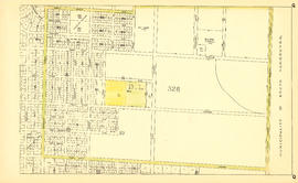
Plan of a 9.783 acre portion of Kitsilano Indian Reserve, District Lot 3610, Group one, New Westminster District [annotated]
Plan of a 9.783 acre portion of Kitsilano Indian Reserve, District Lot 3610, Group one, New Westminster District [annotated]
Map of City of Vancouver. British Columbia
Sheet L : Trafalgar Street to Granville Street and Nanton Avenue to Thirty-eighth Avenue
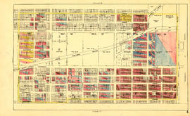
Sheet 11 : Carrall Street to Clark Drive and waterfront to Keefer Street
Sheet 17 : Argyle Street to Vivian Street and Sixty-second Avenue to Kent Street
Sheet 22 : Stanley Park to Burrard Street and waterfront to Robson Street
Sheet 12 : Ontario Street to Clark Drive and Keefer Street to Second Avenue
Sheet 5 : Slocan Street to Boundary Road and Seventeenth Avenue to Twenty-ninth Avenue
Sheet 4 : Slocan Street to Boundary Road and Seventh Avenue to Seventeenth Avenue
Sheet 3 : Slocan Street to Boundary Road and Seventh Avenue to Charles Street
Sheet K : Wallace Street to Trafalgar Street and Twenty-seventh Street to Thirty-eighth Avenue
Sheet Q : Churchill Street to Cambie Street and Thirty-eighth Street to Forty-ninth Avenue
Sheet Z : Milton Street to Heather Street and Seventy-second Avenue to Fraser River and sheet v: Angus Drive to Granville Street and South West Marine Drive to Fraser River
Sheet 7 : Cambie Street to St. George Street and Thirty-seventh Avenue to Forty-eighth Avenue
Sheet U : Churchill Street to Cambie Street and Forty-ninth Avenue to Park Drive
Sheet 14 : Ash Street to St. George Street and Marine Drive to Fraser River
Sheet 12 : Prince Edward Street to Bruce Street and Forty-seventh Avenue to Fifty-eighth Avenue
Sheet 8 : Prince Edward Street to Bruce Street and Thirty-fifth Avenue to Forty-seventh Avenue
Plan of District Lot boundaries. City of Vancouver, B.C.