Aerial view of Downtown Vancouver, West End and Yaletown, with Granville Street Bridge and Burrard Street Bridge, and C.P.R. [Canadian Pacific Railway] train yards
Aerial view of Vancouver City Hall and residential housing, facing east, on Cambie Street
Aerial view of Mount Pleasant, False Creek, at Main Street and Terminal Avenue, with Canadian Central Station, Opsal Steel, Murrin Substation and Georgia Viaduct
Aerial view of False Creek, facing Mount Pleasant and Fairview, with Cambie Street Bridge, Vancouver General Hospital, Vancouver City Hall
Close aerial view of Vancouver City Hall, with Cambie Street and cars
Aerial view of Downtown Vancouver with Stanley Park, North Vancouver, West Vancouver, North Shore mountains and Burrard, Granville and Cambie Street bridges
Aerial view of False Creek at 2nd Avenue with Cambie Street Bridge and Canadian Western Cooperage sawmill
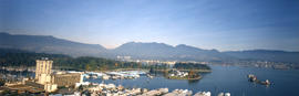
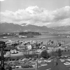
Aerial view of False Creek at Stamp's Landing with Cambie Street Bridge and Heather Civic Marina and Yaletown Marina
Aerial view of Downtown Vancouver and False Creek, with Fairview, Stanley Park, Cambie Street Bridge, North Vancouver, Lions Gate Bridge, and law courts under construction
Aerial view of Downtown Vancouver and False Creek, between Burrard Street and Granville Street Bridge, with train bridge and Granville Island
Project 2, part of area "a" : aerial photograph
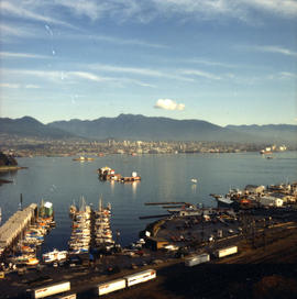
False Creek Construction and Development [31 of 46]
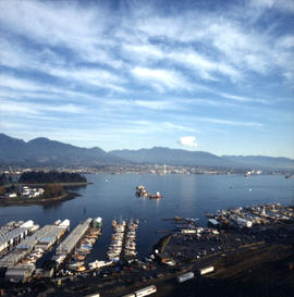
False Creek Construction and Development [32 of 46]
[Aerial view of City of Vancouver, image of printed photograph]
[Aerial view of] Horseshoe Bay, B.C.
General : aerial
Geographical : [untitled]
Geographical : Cranberry farm?
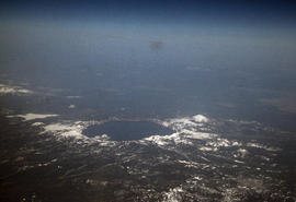
Geographical : Crater Lake
Geographical : Vancouver
Geographical : Vancouver
Historical : aerial
Historical : aerial, holly collection centre
Historical : pre Alma VanDusen, aerial
Historical : Vancouver skyline
Landscape - general : Fraser Valley farmland
Landscape - graphics (plans, etc.) : [untitled]
Landscape - graphics (plans, etc.) : [untitled]
Landscape - graphics (plans, etc.) : aerial
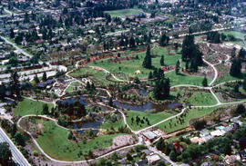
Landscape - graphics (plans, etc.) : stone garden
British Columbia - Vancouver skyline
British Columbia - Vancouver skyline
British Columbia - Vancouver skyline
British Columbia - Vancouver skyline
British Columbia - Vancouver skyline
British Columbia - Vancouver skyline
British Columbia - Vancouver skyline
British Columbia - Vancouver skyline
British Columbia - Vancouver skyline
British Columbia - Vancouver skyline
British Columbia - Vancouver skyline
British Columbia - Vancouver skyline
British Columbia - Vancouver skyline
British Columbia - Vancouver skyline
British Columbia - Vancouver skyline : Westcoast bldg. and scenery from inside
Cleaning for new site
Pacific National Exhibition
[Aerial view of downtown Vancouver showing showing C.P.R Pier D and Pier B-C looking west to Stanley Park]
Campbell River town site : aerial, rollie, streets


![False Creek Construction and Development [31 of 46]](/uploads/r/null/9/2/9205574976d816ba47d939bda896f3fde94e94c8a0f2481dbf912b7a77c24ce7/d7044b05-18e0-4ec3-b11a-31e6b126a974-A66429_142.jpg)
![False Creek Construction and Development [32 of 46]](/uploads/r/null/4/b/4b603b6bc6cb92815ca616a42462305634b9f84c5c2e1705caf02a83efccb0ba/bd80820d-2172-4bbd-80bf-c64a0fb2a357-A66430_142.jpg)
![[Aerial view of City of Vancouver, image of printed photograph]](/uploads/r/null/a/6/5/a6568a4fca40576b2d2b079a13541a80ace37c89086c2a64db6237dfdb087262/fb145724-094b-4d2e-9a60-24df3aef9c61-CVA1095-06997_142.jpg)
![[Aerial view of] Horseshoe Bay, B.C.](/uploads/r/null/8/b/8b6ef59aac19a998092b2943027303676d0dfa0a9385846b7f5b9d0b84dc71e6/efc630d4-f812-4b57-803e-42a6bd292a9b-A02665_142.jpg)

![Geographical : [untitled]](/uploads/r/null/7/8/78aeabde2efd782d9c43b05265ec8b955539ea801d918e244bc44942bf09be66/431ab1c7-2156-4c25-b40d-80b067aa3719-A53945_142.jpg)


![Landscape - graphics (plans, etc.) : [untitled]](/uploads/r/null/4/f/4fbed26539ccf55c230e9edaefc592803c5fde23cd609f0dfd1061594196421b/a0243e9a-ee8a-48a1-8668-91cd52dad7b0-A54243_142.jpg)
![Landscape - graphics (plans, etc.) : [untitled]](/uploads/r/null/a/d/ad347baa27f1b868d25d1650c73b399d89d4945170c84d64ac3f7a37951d7e8c/58aef767-bb3e-4534-ab55-67a5a0fda7d3-A54250_142.jpg)