
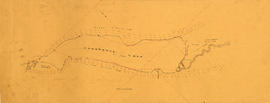
Cheakamus power survey for City of Vancouver 1930-1931. Plan showing topography southward along a line from Cheakamus River
Panorama - Green River Valley from Green lake toward Pemberton Valley

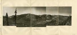
Head of Callaghan Creek and Lower Callaghan Lake

Junction of Cheakamus and Squamish Rivers and Cheakamus Canyon

Hydro electric surveys. Plan showing location of water powers investigated by City of Vancouver

Hydro electric surveys. Plan showing location of water powers investigated by City of Vancouver

Hydro electric survey. Cheakamus River from Squamish River to Brandywine Creek
Cheakamus Lake
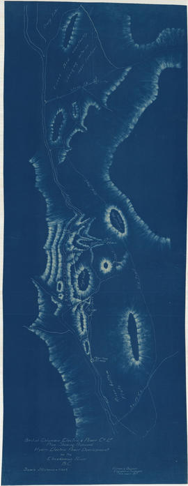
Plan shewing proposed hydro-electric power development on the Cheakamus River B.C.
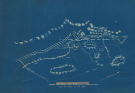
Proposed hydro-electric power development on Cheakamus River

Profile 6 Mile Creek from 2+4240 to 3+1990

Profiles of sections of Green & Soo Rivers
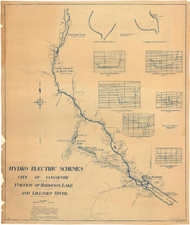
Portion of Harrison Lake and Lillooet River
![Profile of Lillooet River between Lillooet & Tenasse [Tenas] Lake](/uploads/r/null/7/b/8/7b86c7530348c631fba136d04e4b31b414065b7e3f90c8000f45b0b3cc1242c8/bfb1c164-5e71-45ae-add4-e17ffd8c8272-MAP1140_142.jpg)
Profile of Lillooet River between Lillooet & Tenasse [Tenas] Lake

Plan of Pemberton valley from District Lot 758 to Lillooet Lake

Plan of Pemberton valley from District Lot 758 to Lillooet Lake
Cheakamus River. Brandywine Creek to Cheakamus Lake

Contours in Chilliwack Valley near Chipmunk Run

Plan of proposed development of hydro-electric power. Bridge River

General plan of proposed development of Alouette water power

Capilano log jam, lower creek
![Capilano [Creek] looking upstream from north part of island](/uploads/r/null/a/8/a896dc9c2db3c65159f7e2771c98e330ea3c12b91907157c4698e756dbb1826c/b3e6f5a4-4ff6-456c-84bb-263e82325018-A16531_142.jpg)
Capilano [Creek] looking upstream from north part of island
![Capilano [Creek] West Channel looking upstream from lower end](/uploads/r/null/1/1/119d1142158a2f8850f1a5e9d3775af1d6018a3291f1f2d51ee974cad3d03416/ddc2b9d6-276b-4887-9393-165796e72cef-A16533_142.jpg)
Capilano [Creek] West Channel looking upstream from lower end

Thompson River, C.P.R.

Near Ciscom, B.C. C.P.R. Bridge, Fraser River
![[View of] Trail, B.C.](/uploads/r/null/b/5/9/b59df4190185e0fb0954bc0c31bf0dc2e010b09abf22c5108755441031d20616/9ed65958-1adb-4d68-91fe-d08999164c3f-CVA256-02_142.jpg)
[View of] Trail, B.C.

Valley landscape

Henley Regatta - Eton and Leander Race
Streatley

Streatley from above bridge
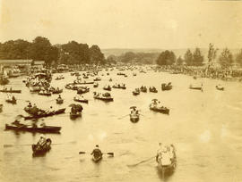
The Regatta - Henley-On-Thames

Crown Creek

Seymour Creek

Seymour Creek

Clearing rock slide at Hell's Gate, Fraser River
![[Waterfront view of Yale - Frazer [Fraser] River](/uploads/r/null/c/b/cb93dac894f555448d19c45ef7ca3ab754bd1169c311d9479183cb3bc3b1ce24/1c23e657-aa7a-49ac-8784-e7f1a94285cb-A22912_142.jpg)
[Waterfront view of Yale - Frazer [Fraser] River
![[Rivers Inlet]](/uploads/r/null/7/2/72d36d666327a3500e94db5daa3d2eeff5528a17563135a81f035dbb98f1c055/f2714c97-da82-4842-8b80-616545b3c4ad-A19580_142.jpg)
[Rivers Inlet]
![[Rivers Inlet]](/uploads/r/null/e/9/e90264a9e3ff958b8981a3aad89044b04029e86bdc29d715eea4b0a52addf974/b890720b-d8eb-48cc-a7e8-74e0c067aa71-A19586_142.jpg)
[Rivers Inlet]
![[Seymour Creek]](/uploads/r/null/3/2/32e56d140023fd893cd4f6147bb56413701f462d65e5dbb8442a372b8db60d7a/1a707ebe-41fc-4d68-a560-cbe4addf262a-A19552_142.jpg)
[Seymour Creek]
![[Unidentified river]](/uploads/r/null/7/c/7c465b50b08cfd44562abb76b326c4efd82b3a673e847a8c02767c311953734d/ef224504-23a8-4f79-8acd-6a3fb737a663-A19634_142.jpg)
[Unidentified river]
![Coquitlam Dam [showing] view downstream from east bank over spillway](/uploads/r/null/8/e/8ed0843af1ad35cee72192f60ec7b36c45244c3acb4a23a26b223ff19e9e8cbe/56af211f-2b69-482f-a6be-cb6cfcf8735f-A32902_142.jpg)
Coquitlam Dam [showing] view downstream from east bank over spillway

The Kicking Horse River, C.P.R.
![[Lytton showing the Fraser and Thompson Rivers]](/uploads/r/null/3/6/363d9af3f46b0dc6bd0041847bf42ae6109d742361f42b0dc748b0f9bd343564/c34bcaf9-67fa-4bee-9112-b595cb68d575-A31726_142.jpg)
[Lytton showing the Fraser and Thompson Rivers]
![[Man fishing with net near] bridge, Rat Portage, Ontario](/uploads/r/null/0/4/04fdeed59c419238cc7415ab07fc9b2fc843e75abfd32d7388e7815bc607e801/d97db068-43c4-4b53-8a3e-8a8d49dabf65-A07961_142.jpg)
[Man fishing with net near] bridge, Rat Portage, Ontario
![[Man spearing salmon in Seymour Creek]](/uploads/r/null/8/7/87148857ce94646d1531f9ee8957aad670b22e3eb8951b4d71247bc0c327733a/31213c49-ad70-4a56-af4f-c2a107c5c701-A04199_142.jpg)
[Man spearing salmon in Seymour Creek]
![[Man standing on log laid across Beaver Canyon]](/uploads/r/null/4/a/4a168c66111fa046a2da1cf47218694ca0cf8405a182eff3e653a9b0a6d82d05/9166132a-8a57-44b3-8f52-3b23b4d89d4a-A07948_142.jpg)
[Man standing on log laid across Beaver Canyon]
![[Hell's Gate on the Fraser River]](/uploads/r/null/7/d/7d9c426ae0e04278d0dddc1daae0c8a3ca38b75cc25820e9fb31cd1ad2aecb7e/43520846-2927-47f0-94f8-a72ede6f306b-A33713_142.jpg)
[Hell's Gate on the Fraser River]
![[Mount Cheops in Glacier National Park]](/uploads/r/null/1/e/1e948fd7244e282a33ba5f0429019862dc633c2c874e0922daaf95b56e50b13f/5d68a8a3-76f8-454e-986c-326dd557d61f-A33007_142.jpg)
[Mount Cheops in Glacier National Park]
![[Five views of Coquitlam Dam construction]](/uploads/r/null/0/e/0ec77062c2e24ed48d3cc4f23e6aa897346cd1466cbbd664f776d3021b5d71d4/e00ad370-7836-4dc7-8e51-baf1ea19522e-A08657_142.jpg)
[Five views of Coquitlam Dam construction]
![[People standing on rocks in Lynn Creek]](/uploads/r/null/b/f/bf78b3ec2f1addde11c6c1253650c10ee4da3fab9d2f5af38151a95174fbf6d3/0126d483-3230-481f-a082-ce3dbf2ab48b-A33037_142.jpg)
[People standing on rocks in Lynn Creek]