![[Crowd on Beatty Street observing Harry Gardiner (the "Human Fly") scale the World Tower]](/uploads/r/null/1/3/136712063612d3090907d20ae1ad561d25c7f1044fe737f567562e1d53cf6c58/8904a603-bc61-4317-bcbc-22fafd0e80b5-A25151_142.jpg)
[Crowd on Beatty Street observing Harry Gardiner (the "Human Fly") scale the World Tower]
- AM54-S4-: Bu P550
- Item
- Oct. 31, 1918
Part of Major Matthews collection
[Crowd on Beatty Street observing Harry Gardiner (the "Human Fly") scale the World Tower]
Part of Major Matthews collection
![[Crowds gathered at Granville and Pender Streets for celebration]](/uploads/r/null/8/e/8ed55281964eb7650332f26122dba1ac22a95af08ca6fc0e35453f4146e45481/963513a4-736f-426e-b3b5-d8fef28a43c0-A07830_142.jpg)
[Crowds gathered at Granville and Pender Streets for celebration]
Part of Major Matthews collection
J.S. Matthews' notes with print or negative in Archives.
![[Exterior of the Post Office - 701 West Hastings Street]](/uploads/r/null/5/8/58224251a9af8ba99d33b9374ab6832ca82fa44b0542cea2875d2cd84b55a7c4/82d70554-e806-4944-9ed2-79cddf87f35e-A25107_142.jpg)
[Exterior of the Post Office - 701 West Hastings Street]
Part of Major Matthews collection
Photograph shows the Winch, Metropolitan and Marine Buildings
![[Ferry line-up on Lonsdale Avenue up to Eighth Street]](/uploads/r/null/0/7/07c1d194551657a593def712e867cd96259b6e82559677fc17d0b3c0ceceb28d/88726415-08cd-4424-9062-15ff90ff2cdf-A24499_142.jpg)
[Ferry line-up on Lonsdale Avenue up to Eighth Street]
Part of Major Matthews collection
![[Fifteenth Street looking east towards Grand Boulevard]](/uploads/r/null/7/3/73a89135f77f03c2170bc52234ba67e4d5b33dd68391be03e9ca3753fb8abd65/1332756e-55c4-4d2a-93f8-9e02d7c4bc28-A33961_142.jpg)
[Fifteenth Street looking east towards Grand Boulevard]
Part of Major Matthews collection

Part of Major Matthews collection
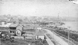
Photograph shows a view looking north from the corner of Westminster Avenue (Main Street) and 7th Avenue including the Westminster Avenue Trestle Bridge and False Creek in the background

Part of Major Matthews collection
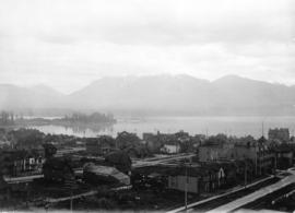
Panoramic view from Pender Street showing the C.P.R. car barge dock, the Immigration Building and Pier A and the squatter's shacks on Deadman's Island

Part of Major Matthews collection
Photograph shows a parade on Hastings Street from Carrall Street

Vancouver, B.C. "The livest and most beautifully located city in Canada"
Part of Major Matthews collection
Panoramic view (280 degrees) taken from the dome of the World Building showing the Beatty Street Armouries, the Cambie Street Grounds, Central High School, Vancouver High School, the Dominion Building, the railway yards and the eastern industrial areas

Vancouver, B.C. from Hotel Vancouver
Part of Major Matthews collection
Photograph shows a view looking east from Georgia Street towards the 600 Block Seymour Street
Part of Major Matthews collection
Photograph shows a view looking west along Alexander Street

Vancouver, Canada, Rotary Club leaving Compressed Gas Company's Office for the Royal Nurseries.
Part of Major Matthews collection
Photograph shows the west side of the 500 block of Howe Street.
![[Panoramic view of downtown, Vancouver from Granville and Hastings Streets]](/uploads/r/null/2/1/6/216cf899114250d1b31f38600b649f3b49bbd0c5882c6b5a6a9519d124d69cd5/addbb40b-0fc9-430e-8ebb-76d531606378-PANP92_142.jpg)
[Panoramic view of downtown, Vancouver from Granville and Hastings Streets]
Part of Major Matthews collection
Photograph is almost a 360 degree view. Buildings and some landmarks are identified in ink on print. This is a cropped version of PAN P92.1.
Written on the back of the print in what appears to be Major J.S. Matthews writing:
"Building permits issued.
Court House, superstructure, 7 Dec 1907 (addition, 30/3/1912)
excavation, 8 Mar 1907
Dominion Trust 21 Apr 1908
Carter-Cotton Bldg (Province Bldg) 5 Oct 1908 (addition Pender St 14/11/10)
Street cars and vehicles:- left hand rule of the road until 1921.
Have not investigated but this looks July or August 1908 or perhaps July-Aug 1909"
![[Third Avenue looking north showing new buildings and businesses]](/uploads/r/null/8/5/859132cdb46d0953c68d4c791872596319ed1242673adc52a4ccbea0d1c552ee/d9183c75-9fba-4bd4-b2f0-f8f6d5a029aa-A33449_142.jpg)
[Third Avenue looking north showing new buildings and businesses]
Part of Major Matthews collection
Photograph shows raised wooden sidewalks
![[Sidewalk construction on Main Street at East 35th Avenue]](/uploads/r/null/9/7/9717d4dcf8f6cb6e0e4bc87440f673d337b65aca4287db4e2d6294b71206d038/f5456cfa-3256-4f97-a89c-2370b3c97520-A09815_142.jpg)
[Sidewalk construction on Main Street at East 35th Avenue]
Part of Major Matthews collection
Photograph shows men and equipment on the side of Main Street and large signs warning of construction zone.
![[Southern view of Samuel and Fitzgerald McCleery's farms - District Lots 315 and 316]](/uploads/r/null/2/9/e/29e5e2ee1ab72e418f96f7141a35b69a66da2b5808f04d8af443c2fdae390ef2/d22eb2ef-a370-4cc4-99f3-9ddec8fddaf8-LP355_142.jpg)
[Southern view of Samuel and Fitzgerald McCleery's farms - District Lots 315 and 316]
Part of Major Matthews collection
Item consists of 3 photographs mounted on board to form a sectional panoramic view of MacDonald Street (Old Kaye Road)
![[Sperling Avenue looking east]](/uploads/r/null/f/9/f920da06add889342c9a54d316497cf061e5c872aa3e486d9fb36a80d8574efb/b6b9d303-f8c5-4376-9205-f4d4682e0afd-A09329_142.jpg)
[Sperling Avenue looking east]
Part of Major Matthews collection
Photograph shows Neale house on northeast corner of Sperling Avenue and Lougheed Highway surrounded by fields and vacant land. Railway tracks visible in the distance.
![[Sperling Avenue looking east]](/uploads/r/null/a/b/ab3bfc916b6f2fbf01857de7d3408c89a440eaebcb36d3c2cc2e077f3a24345b/4e8da1c5-f7c0-4f8f-ae87-e51a89a9e770-A09328_142.jpg)
[Sperling Avenue looking east]
Part of Major Matthews collection
Photograph shows Neale house on northeast corner of Sperling Avenue and Lougheed Highway surrounded by fields and vacant land. Railway tracks visible in the distance.
![[Street in Chilliwack, B.C.]](/uploads/r/null/0/8/082181d30263f8c29364b1165b9fb2fe22e18a52d4a30822f6f3731bc517fba4/6f277c2d-4ce1-4020-a8dd-aca1f84efe60-A08226_142.jpg)
Part of Major Matthews collection
![[Streetcar line construction on Westminster Avenue (Main Street)]](/uploads/r/null/c/d/cd6ae92c940a945bf869cecbbd6cfc810a1c0b210fb431de7ab96c3a0f746f48/2485f482-524d-4662-b9df-0eae6874feac-A37510_142.jpg)
[Streetcar line construction on Westminster Avenue (Main Street)]
Part of Major Matthews collection
Photograph shows a view looking north from near Prior Street

Cut-off, Twelfth Ave. to Tenth Ave. at Trafalgar
Part of Major Matthews collection
Photograph shows streets and houses in area of the Kitsilano diversion.

Part of Major Matthews collection
Photograph shows a marching band on Hastings Street approaching Granville Street and the Leland Hotel Annex

Granville Street south from Connaught Drive Vancouver, B.C.
Part of Major Matthews collection
Photograph shows the clearing for the first Shaughnessy Heights

Part of Major Matthews collection
Photograph shows a view looking west from Cambie Street
![[Looking north from Georgia Street from the Hotel Vancouver]](/uploads/r/null/9/7/97e0cda9e3e6069a38aab5983c020f2d954c7c8d3df3707c37d19bfaefc1ed85/3f1b120e-1142-4754-96b3-399a240e2ec0-A43256_142.jpg)
[Looking north from Georgia Street from the Hotel Vancouver]
Part of Major Matthews collection
Photograph shows the 600 Block between Howe Street and Granville Street including part of the C.P.R. Park, the Van Horne Building and the Bank of Montreal
![[Looking north on Granville Street from Robson Street]](/uploads/r/null/1/1/11bc5a903a1d8cea19de4f74d9b2c73ade4b24a2f8c5e0f9cc2c36a89c0bb4a2/7cc54abc-1fb2-4484-9468-02cf4aeadce4-A37246_142.jpg)
[Looking north on Granville Street from Robson Street]
Part of Major Matthews collection
Photograph shows buildings under construction, the second Hotel Vancouver and the clock tower of the Vancouver Block
![[Looking north on Homer Street from Georgia Street]](/uploads/r/null/5/e/5e74a3f8e2073bde14cdfe7927b3ce23f6545f45a3d4f6c1f72dacc1c2d3ced2/2f401444-1c76-40f6-9b7d-0f4a4d7b5064-A37175_142.jpg)
[Looking north on Homer Street from Georgia Street]
Part of Major Matthews collection
Photograph shows the Hopps Sign Company, Smith Marking Device Company and the Alcazar Hotel
![[Looking northeast from Georgia Street from the Hotel Vancouver]](/uploads/r/null/8/a/8a3cf4ec45565ce8c42c5be70e3dc9bba77700670833bbf6543e337be1a6b54e/111407b8-0df6-4047-899b-7bcaf3802d1e-A43264_142.jpg)
[Looking northeast from Georgia Street from the Hotel Vancouver]
Part of Major Matthews collection
Photograph shows the east side of the 600 Block of Granville Street and beyond including the New York Block, the Simpson Block, the Crew Block, Homer Street Methodist Church, St. Anne's Academy and Holy Rosary Church (before the steeple was built)
Part of Major Matthews collection
Photograph shows the west side of the 600 Block of Howe Street including Manor House
![[Looking west along Georgia Street at Howe Street from the roof of the second Hotel Vancouver]](/uploads/r/null/e/a/eaf470ff6789cc2b12ce452e09b469421aa6854a8793f4caef7b539b19c66e58/dc88c4dd-55eb-431c-9db6-31525dadd68c-A25786_142.jpg)
[Looking west along Georgia Street at Howe Street from the roof of the second Hotel Vancouver]
Part of Major Matthews collection
Photograph shows Walker and Robinson Nursery and Christ Church Cathedral
![[Looking west on Buckland Road (West 29th Avenue) from Alma Road (Street)]](/uploads/r/null/0/0/00845954f4d465c43deb4d2e806a6e23524a0dd93df1366dee8518bdfc6da7a4/6293bd29-39c0-4713-951e-7a0ba8a90599-A36986_142.jpg)
[Looking west on Buckland Road (West 29th Avenue) from Alma Road (Street)]
Part of Major Matthews collection
Photograph shows the Convent of the Sacred Heart under construction
![[Looking west on Hastings Street from Cambie Street]](/uploads/r/null/6/d/6deb362624bf0a74479bcdb421752a0dedd250383cf857bbb6f07e3a7196c1b9/a4489734-6e92-4556-acfa-c03ff64cbc8e-A36987_142.jpg)
[Looking west on Hastings Street from Cambie Street]
Part of Major Matthews collection
Photograph shows The Inns of Court Building (423 Hamilton Street at West Hastings) and Arcade building
![[Looking west on Hastings Street from Cambie Street]](/uploads/r/null/5/d/5de9e3a6fa10e1e67dab45029bef3bd4ec4bcb4db0f584480b2eb9cfaab54e21/f2afbd2c-51b3-4782-ad97-8d90c142b1ba-A37021_142.jpg)
[Looking west on Hastings Street from Cambie Street]
Part of Major Matthews collection
Photograph shows the Dominion Bank building, the Bank of Hamilton building, the cenotaph and the Marine Building
![[Looking west on Hastings Street from Cambie Street]](/uploads/r/null/f/a/fa39c28ebccb344bc3c6e3ca061e971a64c6d148cdfb7139b2873fe15a94e64b/7b0a1c8a-87a5-4809-abdc-4a00a52d25a5-A37235_142.jpg)
[Looking west on Hastings Street from Cambie Street]
Part of Major Matthews collection
Photograph shows the Arcade and the Inns of Court Building (423 Hamilton Street at West Hastings).
![B.C. Electric [Hydro Building - 970 Burrard Street under construction]](/uploads/r/null/0/4/048a598c0484e07c09746fcbd1d195b27aca7c408c10eb4759059774f1bc2f59/2f77bbb5-e09b-4dd7-abf7-b339c90d030d-A25112_142.jpg)
B.C. Electric [Hydro Building - 970 Burrard Street under construction]
Part of Major Matthews collection
Photograph shows the Hotel Vancouver
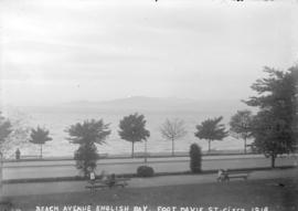
Beach Avenue English Bay, foot Davie St.
Part of Major Matthews collection

Columbia Street Great Westminster Fire
Part of Major Matthews collection
![Cordova St[reet looking west from Carrall Street] : July 1886 - five weeks after the fire.](/uploads/r/null/d/a/da3a4547492592c411a4707bbcd6a591ecb4b4cc60db1a8ffc34127a4bc102f1/73845f2c-7ef4-4f2e-8beb-ebb16a617702-A63595_142.jpg)
Cordova St[reet looking west from Carrall Street] : July 1886 - five weeks after the fire.
Part of Major Matthews collection
Photograph shows businesses being rebuilt after the great fire. Some businesses in the photograph are: Burrard Hotel, Tom Dunn Hardware, Grant & Arkell, Dietz (sp?) Winch, Daily News (on Hastings Street), Sekl's Furniture Store, Dougall House, Tom McDonald (on Pender Street), Mathison the Printer (on Hastings Street), Cosmopolitan Hotel, Mizony's Restaurant, F.W. Hart Furniture, Tilley's (sp?) Book Store and the Telephone Exchange.
Cordova Street looking east from Cambie Street, Vancouver
Part of Major Matthews collection
![Cordova Street Looking West [from Carrall Street]](/uploads/r/null/1/2/12f121470b5d1c1c416f1ae59743e965b1f15d1d87ca1a24879ad7a39ecfdbab/f07061d9-45de-4daf-b38c-2310ebc6507e-A37084_142.jpg)
Cordova Street Looking West [from Carrall Street]
Part of Major Matthews collection
Photograph shows the Dunn-Miller Block
![[View of the last Vancouver Lulu Island inter urban tram near 41st Avenue and West Boulevard]](/uploads/r/null/c/7/c715e285bdfbbf1452f4d508f757efdd5a46b36dd8ebd2541123720536fe6b23/85e878f3-5c22-4418-858a-9f02c76bdd3f-A25954_142.jpg)
[View of the last Vancouver Lulu Island inter urban tram near 41st Avenue and West Boulevard]
Part of Major Matthews collection
Photograph shows Lucas Motors and other businesses in the 5600 5500 blocks of West Boulevard
![[View of the south side of the 700 and 800 Blocks of Hastings Street]](/uploads/r/null/c/9/c9a16ecf9a09cde61b3b86e48983c8f56810c67cbceb10f8aab9ebeeed5afde0/15767e7c-e06c-4520-bc90-8a65440497cb-A25196_142.jpg)
[View of the south side of the 700 and 800 Blocks of Hastings Street]
Part of Major Matthews collection
Photograph shows signs on the Williams Building (Mackinnon Block) for the Liberal Headquarters, Dr. Max M. Johnson, Cunningham's Drug Store and Leonard's Cafe, Harwood Taxi and The Pacific Building and the Credit Foncier Building
![[View of the west side of Granville Street from Broadway]](/uploads/r/null/4/4/440ccd6f3a83aa21b44b892408bebd21b44e57a43a97907a458d7af39bf9daf8/97aec341-0911-409c-9ab7-04eafba3de55-A37370_142.jpg)
[View of the west side of Granville Street from Broadway]
Part of Major Matthews collection
Photograph shows part of the Aristocratic coffee shop and other businesses
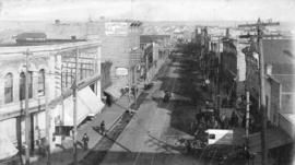
![[View of Westminster Avenue looking north from street car terminus at 9th Avenue]](/uploads/r/null/2/1/219c444e883f60eea950b3298df282a77c8581b8a0a18dd210fdc1e252b51d7e/690f5386-3dcb-43a0-aeb8-19a0017e8a2b-A09809_142.jpg)
[View of Westminster Avenue looking north from street car terminus at 9th Avenue]
Part of Major Matthews collection
![[View of] Anyox, B.C.](/uploads/r/null/7/2/6/726fe59560c618f43f32718b12a695effd3ffa7bb87f511e5c38e1f11644dd8f/3aa3ddc9-e711-4c4d-9e4b-b50148789010-LP312_142.jpg)
Part of Major Matthews collection
Panoramic view shows wooden streets and sidewalks, clear cut logging and Consolidated Mining and Smelting Co.
![[View of] Burrard St. north from Nelson](/uploads/r/null/7/4/742d8be5814b808daaa6bb397670b77301289c24dac9d0f9462c7afb92777355/2232be01-bffe-40e9-b525-7c427f61fb76-A09748_142.jpg)
[View of] Burrard St. north from Nelson
Part of Major Matthews collection
![[View of] Granville St. looking north from Pender](/uploads/r/null/2/a/2a8e39f07d903c31141d994fe7638a1d860be44af3533872dca3b509532c5bfa/17ccdc5f-81ac-4cb4-8408-030636f1e753-A09732_142.jpg)
[View of] Granville St. looking north from Pender
Part of Major Matthews collection
![[View of] Hastings St. looking east from Hornby](/uploads/r/null/0/4/0470bb9219d126f8bcb407384a6c7238af2d2ff2ec3164ebef90189a224d525d/5d8e50db-7c1a-48a8-9ddf-e12cb8356c36-A09734_142.jpg)
[View of] Hastings St. looking east from Hornby
Part of Major Matthews collection
Photograph shows the Winch building, the stone wall around the home of C.T. Dunbar, a horse and cart in the street and wooden sidewalks.
![[View of] Hastings St. looking west from Abbott St.](/uploads/r/null/3/a/3a0ad01f4dca36c49bca2011934a7d81e38ee9fc4a2b4f2acab4202fcffbc4df/03d18501-38b5-4364-accb-3bb70b48aea6-A09712_142.jpg)
[View of] Hastings St. looking west from Abbott St.
Part of Major Matthews collection
Photograph shows the Woodward's store and businesses along Hastings Street.
![[View of] Melville Street](/uploads/r/null/0/2/02a74c2e426279017c49447848326e871b4fa2b003841cccb35bedd4a59b1fe2/7d361e5f-ef54-4f72-8bb1-4179a08b9fba-A09737_142.jpg)
Part of Major Matthews collection