![[Clearing the townsite for Prince Rupert]](/uploads/r/null/5/7/57a083ee5b843609cca2544b36999b5cd83960b360677ef7580178ca168590d5/88daa4bb-f2bf-4e0d-aaaa-b74b93dba04d-A33677_142.jpg)
[Clearing the townsite for Prince Rupert]
- AM54-S4-: Out P773
- Item
- May 1906
Part of Major Matthews collection
184 results with digital objects Show results with digital objects
[Clearing the townsite for Prince Rupert]
Part of Major Matthews collection
![[Third Avenue looking north showing new buildings and businesses]](/uploads/r/null/8/5/859132cdb46d0953c68d4c791872596319ed1242673adc52a4ccbea0d1c552ee/d9183c75-9fba-4bd4-b2f0-f8f6d5a029aa-A33449_142.jpg)
[Third Avenue looking north showing new buildings and businesses]
Part of Major Matthews collection
Photograph shows raised wooden sidewalks
Herring Fishing Prince Rupert Harbor
Part of Major Matthews collection
![[Prince Rupert]](/uploads/r/null/e/2/e23e08384a692110cf44bf98c604d48adc09ff003209134dec12abe2221f32e5/33331a5c-df35-49c7-915f-b6992953867f-A33679_142.jpg)
Part of Major Matthews collection
Photograph shows the Grand Trunk Pacific Railway Hotel
![[S.S.] Camosun Prince Rupert B.C.](/uploads/r/null/f/5/f55cc44981349dacd10f607b1076f81a077b1cfcb073eef415d85b7044f685bf/9496ef5a-ed21-4713-a597-a69655901792-A24124_142.jpg)
[S.S.] Camosun Prince Rupert B.C.
Part of Major Matthews collection

Item is a map of the Prince Rupert, British Columbia area showing lands alienated or covered by applications under the Land Act, timber leases, First Nations reserves, land district, provincial forest, and park boundaries, forest management licences, municipalities, post offices, hospitals, sub-mining recording offices, railways, roadways, airports, seaplane anchorages, elevations, telephone and power lines, and glaciers. An index map shows the area covered by the primary map in relation to the rest of British Columbia and other maps published in the series.

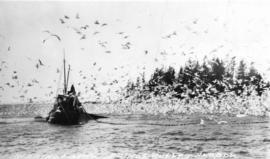
Prince Rupert : church and totem; fish nets and boats; CNR truck; halibut etc.

Prince Rupert : totems, harbour, halibut, cold storage, Atlin, fishing, Jack Long

Prince Rupert : totems, harbour, halibut, cold storage, Atlin, fishing, Jack Long

Prince Rupert : totems, harbour, halibut, cold storage, Atlin, fishing, Jack Long

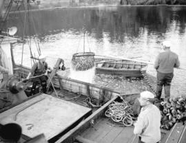
Prince Rupert : loading fish, harbour scenes
Prince Rupert : loading fish, harbour scenes

Prince Rupert : Atlin Fisheries Ltd., Northern Fisheries Storage, dock scenes : Jack Long

Prince Rupert : fish and dock scenes

Prince Rupert : fish and dock scenes

Prince Rupert : misc., church, totems, fish, etc. : Jack Long

Prince Rupert : misc., church, totems, fish, etc. : Jack Long
![Mrs. O. Larson [at Nelson Brothers Salmon] Cannery](/uploads/r/null/7/2/7290b2489041d23aafa26907dfeab0c8e072a90dbdcd6b34d7bd7a1649397ef8/c21e86b5-c239-4623-9fbf-d51068fd6475-A07300_142.jpg)
Mrs. O. Larson [at Nelson Brothers Salmon] Cannery

Prince Rupert drydock and berths
Photograph shows the "Fort Mumford" in the background
![Totem [pole which originally stood in the Nisga'a village of Gitlakdamix]](/uploads/r/null/2/8/28f264bc5b29f1c969f670c5de2ed3a26c8a101fcb5d1225be24c577e52a072a/9eddada6-5716-4a2a-b73b-0febd55c4ce3-A03473_142.jpg)
Totem [pole which originally stood in the Nisga'a village of Gitlakdamix]

Fish boat "Yakutat" of Ketichan at Prince Rupert dock
Inscription on verso of print "#2308 - Halibut boat at Prince Rupert. / Photo - Don Coltman"
![Fishing boats at Prince Rupert [docks]](/uploads/r/null/5/7/57cad72795de5981d5a1b74a4b6e885953b245c18485282f0028b8559053341c/2d2e9b4d-9594-40be-8441-6632a03ff306-A07220_142.jpg)
Fishing boats at Prince Rupert [docks]
Thor and Mikof boats indentified in photograph.


!["Fort Mumford" [approaching drydock]](/uploads/r/null/e/b/eb55db6a26b011d603e9141ad4e1f604226149f3c8a7f5de0cc184f3b7fd0705/a925af65-627c-4daa-b1f4-e7c31e93a3cf-A07534_142.jpg)
"Fort Mumford" [approaching drydock]

![[A worker moving a pallet of cans] into an oven](/uploads/r/null/1/d/1de5f268fd59b7c103c911a10c6e7c9e86ab8b701eab072245fe28c6adbe7006/c0726113-5501-4bdf-92d9-7198dc71a89b-A07316_142.jpg)
[A worker moving a pallet of cans] into an oven
![[A worker sorting salmon]](/uploads/r/null/6/7/67d8047c8e6478ee15080e6e75a372164b9083cc07b053665b11e13d1b014757/5b7d586e-aa6d-4075-96fa-4fed63094f96-A07312_142.jpg)
![[Women washing salmon inside a] cannery](/uploads/r/null/f/5/f568528190283fb8fa63d47c99b9ed572b5c2b607733fc66ba2a6f30e4c9a68f/41aa5775-ff55-4c83-af7f-d1708326fde0-A07305_142.jpg)
[Women washing salmon inside a] cannery
![[Worker operating a can-sealing machine]](/uploads/r/null/8/6/867b625657a3b753a1d908dd08bb4b726fdd9f773b7e2500d524237216c730e9/cd1f6f99-99b6-489f-87b4-52d2b0f147d0-A07310_142.jpg)
[Worker operating a can-sealing machine]
Inscription on verso of print "#2805 After the addition of salt the cans are topped. / Don Coltman Photo"
![[Workers processing salmon]](/uploads/r/null/c/8/c8a524377502e1ea2844f04fea774fcf614833a1fb28e8b2db9b8b3673414e16/6019e608-34f3-4617-93ed-440ed73b3ae5-A07308_142.jpg)

Canadian Fish & Cold Storage Company and fleet
Part of Imperial Oil Company fonds

445000 lb - 20 car loads - halibut awaiting transportation
Part of Imperial Oil Company fonds

World Circumnavigational Flight
Part of Imperial Oil Company fonds
Item is a photograph on which these words appear "Four American Aeroplanes, leaving Prince Rupert, B.C. for Sitka, Alaska, April 9/24. Around the world flight.
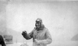
World Circumnavigational Flight
Part of Imperial Oil Company fonds

Part of James Crookall fonds
![[A post office in a tent]](/uploads/r/null/0/5/052bc18a1e6a4305c8816b11f08868f0c89cc5a3b3e3bea95f9f62bf62319777/bcc93fda-8c7f-4662-b460-9aea0a6e6ccd-A33535_142.jpg)
Part of Major Matthews collection
Photograph shows Mr. McIntosh, postmaster on a raised wooden sidewalk
Part of BC Gay and Lesbian Archives

First Team Hitched Up at Prince Rupert
Part of Major Matthews collection

Government Buildings Prince Rupert, B.C.
Part of Major Matthews collection

Part of Major Matthews collection
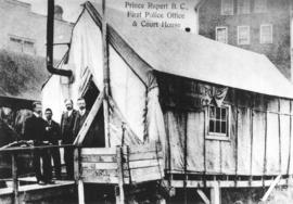
Prince Rupert, B.C. First Police Office and Court House
Part of Major Matthews collection

Part of Major Matthews collection

World Circumnavigational Flight
Part of Imperial Oil Company fonds

Part of Major Matthews collection
Photograph shows cleared land and a real estate sign
![[N.A. Beketor and his son Paul (a sea cadet)]](/uploads/r/null/2/1/2191afa21d00038fef1024fa8775fe1617d9289dc161f2921d386d415a3c2048/70496440-db5e-4315-aa6b-d09169fb4a0e-A60339_142.jpg)
[N.A. Beketor and his son Paul (a sea cadet)]
Part of Major Matthews collection
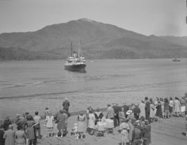
![[View of the C.N.R. Steamer "Prince Robert" leaving the harbour]](/uploads/r/null/8/a/8a6323d7a16c0faa7ae1ef9957458a1426ce27d351882b31c7be654facb0dd32/f109bb7b-6762-4382-a067-8fcadbef4b02-A60336_142.jpg)
[View of the C.N.R. Steamer "Prince Robert" leaving the harbour]
Part of Major Matthews collection

Part of James Crookall fonds

Part of James Crookall fonds