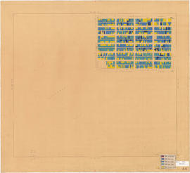
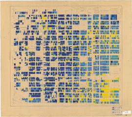
Part is a section depicting the area bounded by Slocan Street to Eighteenth Avenue to Knight Street to Twenty-ninth Avenue. The sheet has been extensively annotated, with colour coded areas to depict land use, status of lots as tax sale properties for sale, sewer and water lines, as well as other colour codes that are not noted on the legend at the front of the volume.
Part is a section depicting the area bounded by Slocan Street to Burrard Inlet to Clark Drive end to Triumph Street. The sheet has been extensively annotated, with colour coded areas to depict land use, status of lots as tax sale properties for sale, sewer and water lines, as well as other colour codes that are not noted on the legend at the front of the volume.
Part is a sheet depicting the area bounded by Clark Drive to Keefer Street to Ontario Street to Third Avenue. The sheet has been extensively annotated, with colour coded areas to depict land use, status of lots as tax sale properties for sale, sewer and water lines, as well as other colour codes that are not noted on the legend at the front of the volume.
Part is a section depicting the area bounded by Knight Street to Fifteenth Avenue to Main Street to King Edward Avenue. The sheet has been extensively annotated, with colour coded areas to depict land use, status of lots as tax sale properties for sale, sewer and water lines, as well as other colour codes that are not noted on the legend at the front of the volume.
Part is a section depicting the area bounded by Howard Street to Fourth Avenue to Oak Street to Sixteenth Avenue. The sheet has been extensively annotated, with colour coded areas to depict land use, status of lots as tax sale properties for sale, sewer and water lines, as well as other colour codes that are not noted on the legend at the front of the volume.
Part is a section depicting the area bounded by Maple Street to Third Avenue to Trutch Street to Sixteenth Avenue. The sheet has been extensively annotated, with colour coded areas to depict land use, status of lots as tax sale properties for sale, sewer and water lines, as well as other colour codes that are not noted on the legend at the front of the volume.
Part is a section depicting the area bounded by Columbia Street to Burrard Inlet to Burrard Street to Robson Street. The sheet has been extensively annotated, with colour coded areas to depict land use, status of lots as tax sale properties for sale, sewer and water lines, as well as other colour codes that are not noted on the legend at the front of the volume.
Part is a section depicting the area bounded by Granville Street to Robson Street to Stanley Park to English Bay/False Creek. The sheet has been extensively annotated, with colour coded areas to depict land use, status of lots as tax sale properties for sale, sewer and water lines, as well as other colour codes that are not noted on the legend at the front of the volume.
Part shows a map of the City of Vancouver extending from Boundary Road to Burrard Inlet to Alma Street to King Edward. Lot numbers and street names are shown, along with ward lines, district lot lines street railway lines and railroad lines represented by a legend in the bottom left corner.
Part is a map showing lot numbers, lot sizes, lot values and sidewalk crossings in the area from Rosemont Drive in the north to 63rd Avenue in the south and from Butler Street in the east to Kerr Street in the west.
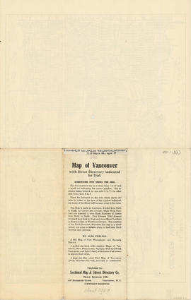
Part contains directions for using the dial map and text advertising other publications from the Sectional Map and Street Directory Co. Part includes J.S. Matthews's annotation that the map was "Presented, 23 Apr. 1942, by Robt. Morton, publisher, 2119 Maple St. aged 87."
Part contains two pages from the booklet accompanying a guide map of Greater Vancouver. Pages include the last portion of the Vancouver and Burnaby street index, the New Westminster street index, and the North Vancouver street index from 1st Street to Frederick Road.
Part contains four maps. The main map shows district lots and block numbers in Vancouver from Vine Street in the west to Boundary Avenue (Glen Drive) in the east and Stanley Park in the north to 9th Avenue (Broadway) in the south. Three smaller maps include an index plan to district lots in Vancouver, South Vancouver, New Westminster, and Burnaby; a world map showing Canadian Pacific mail steamship lines; and an index plan of Vancouver city limits. Part has been annotated with text describing a June 1888 land clearance plan and hand colouring indicating clearance status.
Part contains a map of East Vancouver Heights showing streets, block numbers and lot numbers, an index map showing the location of East Vancouver Heights in relation to the rest of the city, and text promoting the area.
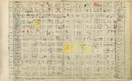
Part contains a map showing ward and poll numbers and locations in the City of Vancouver from Burrard Inlet in the north to the Fraser River in the south and from Boundary Road in the east to Blanca in the west.


![Vancouver, B.C., the Pacific coast terminus of the C.P.R. [Canadian Pacific Railway]](/uploads/r/null/8/3/f/83fcf65f0d66d64e6357d0d647e0ea6e2fa4aae4c3d1919f952d7725b4299cda/623e750c-fbab-43b7-a496-d20b384baeb6-LEG1321_142.jpg)