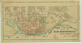
Showing 1440 results

Archival description
City of Vancouver Archives technical and cartographic drawing collection With digital objects
Print preview View:

False Creek, Vancouver, B.C.

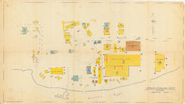
Item is a map showing street names and major landmarks around False Creek during Expo 86. Major pavilions on the fair site are labeled. An index map in the lower right-hand corner of the map shows the location of the primary map in relation to the rest of Greater Vancouver and the United States. The map also includes a short chronology of the history of False Creek and Granville Island. The cover of the envelope depicts a smaller version of the map.

Lot numbers, boundaries, railway lines and street names in the municipality of Point Grey

Primary map shows lot numbers, boundaries, railway lines and street names in the municipality of Point Grey from 16th Avenue in the north to the Fraser River in the south and from Ontario Street in the east to Blanca Drive in the west. A smaller map in the bottom left-hand corner of the item shows the north west portion of Point Grey.

Redevelopment plan for Jericho Department of National Defence lands

Item is a map showing proposed redevelopment of portions of former Department of National Defence lands in the Jericho area. The map shows existing city parks, D.N.D. lands to be taken over for parks and recreation, city owned land, single family land, town houses, garden apartments and town houses and proposed new roads. The map appears to have been removed from a report.

Vancouver (B.C.). Engineering Services

Plan showing locations of oil and gas seepages and oil wells in Fraser Valley, British Columbia

Item is a map which shows rivers and streams, oil and gas seepages, oil wells drilled, towns and villages and railway lines from Pitt Lake in the north to the United States border in the south and from Chilliwack in the east to the Strait of Georgia in the west.

Haggen, E.A.

Vue de diverses parties de la côte nord-ouest d'Amérique

Item is a graphical plate from an atlas, showing views of Cape Scott, Scott Island, the entrance to Nootka Sound, Woody Point, the entrance to the Columbia River, and Point Barro de Arena. The item is a plate from a French reprinting of "A Voyage of Discovery to the North Pacific Ocean and round the world..." by George Vancouver.

Vue de diverses parties de la côte nord-ouest d'Amérique

Item is a graphical plate from an atlas, showing views of Cape Mendocino, Cape Orford, Grenville Point, the entrance to the Straits of Juan de Fuca and the coastline south of Cape Flattery. The item is a plate from a French reprinting of "A Voyage of Discovery to the North Pacific Ocean and round the world..." by George Vancouver.

Insurance plan of Port Coquitlam : key plan and sheet 1

Part contains the key plan for the insurance plan of Port Coquitlam, an inset map of the area bounded by Shaughnessy Street, Central Avenue, and Rindall Avenue, and a section of the insurance plan covering Dewdney Trunk Road where it crosses the Coquitlam River. Map shows legal descriptions, street widths, building dimensions and types (dwelling, office, industrial, other commercial use), names of businesses, and other features of the built environment relevant to insurance claims.

Insurance Plan of Port Coquitlam : sheet 4

Part contains a section of the insurance plan covering the area bounded by Chester Street, Cambridge Street, Grant Avenue, and Suffolk Avenue. Map shows legal descriptions, street widths, building dimensions and types (dwelling, office, industrial, other commercial use), names of businesses, and other features of the built environment relevant to insurance claims.

Information concerning the City and District of New Westminster and the Province of British Columbia

Part is the text side of a pamphlet. This part contains information concerning the city and district of New Westminster, with individual panels on the municipalities of Delta, Chilliwhack [sic], Surrey, Langley, and Delta, and the City of New Westminster, the town of Harrison Hot Springs and the province.

City of Vancouver

Map is a City Engineering Department base map of Vancouver, showing city blocks and Canadian Pacific, Canadian National and Great Northern Railway lines. Parks, golf courses, hospitals, schools, theatres and other structures are identified. "Metric Vancouver" and "Guide Map 15" appear in the bottom right corner of the map.

Town-site of Hastings

Map shows Hastings Town-site, Granville Town-site, Burnaby, and the City of New Westminster. Map also shows the Road from Granville and the False Creek Trail, as well as the names of places and soil types found along these roads. Other places and structures noted include Burrard Inlet, Coal Harbour (Coal Harbor on map), False Creek, False Creek Bridge, Burnaby Lake, Fraser River, New Westminster and Burrard Inlet Road, Douglas Road, Edinburgh Street, Columbia Street, Richards Street, and the New Westminster Cemetery. Two notes on map read "Plan to accompany Report of 1st May 1883, Joseph Hunter" and "Memo: Mr. Ross will place [?] this map to the [Engs.] Office Victoria [?]." 14T3 Roads & Trails is printed on the side of the map.

Chinatown existing

Item is an annotated photocopy of a map of Chinatown showing streets, buildings and the number of stories in each building. Includes the area bounded by Taylor Street, Hastings Street, Gore Avenue and Keefer Street. The Provincial Historic Site Boundary, designated February 2, 1971, is drawn and indicated on the map. Notations pertaining to the boundary and the indication of the number of stories in each building appear on the map.

Canadian Pacific Railway. Plan of part of branch line from Port Moody. A point on main line C.P.R. to English Bay, B.C.

Map shows a survey conducted by the Canadian Pacific Railway of English Bay, Burrard Inlet and Coal Harbour, including a rough outline of area and lots. Note on map reads "Certified as a correct plan showing the land required for right of way Burrard Inlet B.C., February 22, 1886. H.J. Cambie, Engineer in Charge." Map is certified as correct and signed by various C.P.R. officials, including W.C. Van Horne.

Vancouver, B.C. Plan showing location of water pipes, hydrants, etc. [Fairview slopes]

Item is a map showing the location of water pipes and hydrants for the area bounded by Scotia Street, False Creek, Spruce Street and Tenth Avenue (D.L. 526, D.L. 302 and D.L. 200). Block 6 in D.L. 200 was covered by an overlay depicting a later sub-division. Pipes and hydrants are shown in various coloured inks to indicate installation date. Annotations have been drawn on a base map that was part of a larger map.

Vancouver (B.C.). Water Works Department

Vancouver, B.C. Plan showing location of water pipes, hydrants, etc. [Westminster Avenue to McLean Drive]

Item is a map showing the location of water pipes and hydrants for the Downtown Eastide and Strathcona west of McLean Drive (D.L. 181, D.L. 182B, D.L. 196). The sheet also includes an inset map of the area bounded by Columbia Street, Alexander Street, Westminster Avenue and Powell Street. Pipes and hydrants are shown in various coloured inks to indicate date of installation.

Vancouver (B.C.). Water Works Department

[Map of Pioneer Place showing the area deeded to the City of Vancouver by the C.P.R.]

Item is a hand drawn map of Pioneer Place (also known as Pigeon Park), on the corner of Hastings and Carrall Streets. Map is colour coded to indicate the portion deeded to the City by the C.P.R., the portion being asked from the C.P.R. for street purposes, and the portion leased by the C.P.R. to Mr. Horne. Included on the map are Horne Block, Garden Block, a sidewalk, lanes, and a fountain. An engineer's estimates of improvements are noted on the right side of the map. Notes at the top of the map by J.S. Matthews, City Archivist read "Presented in 1934 by Ex-Alderman W.H. Gallagher. The date is about 1895."

Map of portion New Westminster District

Item is a heavily-amended copy of a map illustrating intended land settlement and subdivision in 1877 in the future sites of Vancouver, Burnaby and the North Shore, from an area bordering on English Bay to an area bordering on North Arm. Also shown are bodies of water, Hastings & Granville Road, and the settlements of Hastings and Granville. Annotations by J.S. Matthews in 1954 made on the copy are tracings in white pen and darkening the background to improve the copy.

Vancouver sheet, British Columbia

Item is a map of Vancouver Island and the southwest portion of mainland British Columbia from Bella Coola to Clinton, and south to New Westminster. Map shows geological, land district, and park boundaries; locations of mining recording offices and sub-offices; elevations in feet above sea level; mineral occurrences; and the development of geological formations by era.

Sheet 5 : Slocan Street to Boundary Road and Seventeenth Avenue to Twenty-ninth Avenue

Item is a section showing the area from Slocan Street to Boundary Road and Seventeenth Avenue to Twenty-ninth Avenue. Includes streets and roads, blocks, lots, legal descriptions, railways, parks, schools and the Vancouver Preventorium (for tuberculosis patients).

Vancouver (B.C.). Office of the City Engineer

Sheet 7 : Clark Drive to Slocan Street and Seventh Avenue to Eighteenth Avenue

Item is a section showing the area from Clark Drive to Slocan Street and Seventh Avenue to Eighteenth Avenue. Includes streets and roads, blocks, lots, legal descriptions, railways, parks and schools. Some annotations have been made in green ink.

Vancouver (B.C.). Office of the City Engineer

Sheet 13 : Ontario Street to Clark Drive and First Avenue to Sixteenth Avenue

Item is a section showing the area from Ontario Street to Clark Drive and First Avenue to Sixteenth Avenue. Includes streets, roads, blocks, lots, legal descriptions, railways, parks and schools. Includes B.C. Electric Railway car barns.

Vancouver (B.C.). Office of the City Engineer

Sheet 14 : Main Street to Knight Street and Fifteenth Avenue to King Edward Street

Item is a section showing the area from Main Street to Knight Street and Fifteenth Avenue to King Edward Street. Includes streets and roads, blocks, lots, legal descriptions, parks, schools and businesses.

Vancouver (B.C.). Office of the City Engineer

Sheet B : Imperial Street to Trutch Street and waterfront to Fourth Avenue

Item is a section showing the area from Imperial Street to Trutch Street and waterfront to Fourth Avenue. Includes streets, roads and sewers; blocks, lots and legal descriptions; and parks and schools. Map shows Jericho Air Station and crown leases.

Vancouver (B.C.). Office of the City Engineer

Sheet C : University Endowment Lands to Imperial Street and Fourth Avenue to Sixteenth Avenue

Item is a section showing the area from the University Endowment Lands to Imperial Street and Fourth Avenue to Sixteenth Avenue. Includes streets, roads, blocks, lots, legal descriptions, parks and schools.

Vancouver (B.C.). Office of the City Engineer

Sheet D : Imperial Street to Trutch Street and Fourth Avenue to Sixteenth Avenue

Item is a section showing the area from Imperial Street to Trutch Street and Fourth Avenue to Sixteenth Avenue. Includes streets and roads; blocks; lots and legal descriptions; and parks, schools and golf courses.

Vancouver (B.C.). Office of the City Engineer

Sheet F : Wallace Street to Trafalgar Street and Sixteenth Avenue to Twenty-seventh Avenue

Item is a section showing the area from Wallace Street to Trafalgar Street and Sixteenth Avenue to Twenty-seventh Avenue. Includes streets, roads, blocks, lots, legal descriptions, parks and schools.

Vancouver (B.C.). Office of the City Engineer

Sheet J : University Endowment Lands to Wallace Street and Twenty-ninth Avenue to Thirty-eighth Avenue

Item is a section showing the area from the University Endowment Lands to Wallace Street and Twenty-ninth Avenue to Thirty-eighth Avenue. Includes streets, roads and sewers; blocks, lots and legal descriptions; and parks and schools.

Vancouver (B.C.). Office of the City Engineer

Sheet S : Musqueam Reserve to Macdonald Street and Forty-ninth Avenue to Fraser River

Item is a section showing the area from Musqueam Reserve to Macdonald Street and Forty-ninth Avenue to the Fraser River. Includes streets and roads; blocks, lots and legal descriptions; and parks and golf courses.

Vancouver (B.C.). Office of the City Engineer

Sheet U : Churchill Street to Cambie Street and Forty-ninth Avenue to Park Drive

Item is a section showing the area from Churchill Street to Cambie Street and Forty-ninth Avenue to Park Drive. Includes streets and roads; blocks, lots and legal descriptions; and parks and golf courses.

Vancouver (B.C.). Office of the City Engineer

Results 1 to 50 of 1440