
Proposed industrial subdivision - Joyce and Vanness

Project 2 : generalized plan of redevelopment

Project 2, part of area "a" : condition of buildings

Project 2, part of area "a" : existing utilities, water and sewer

Project 2, part of area "a" : existing gas, electricity and telephone

Project 2, area "h" and part of "b" : condition of buildings

Project 2, area a-2 : condition of buildings

Project 2: identification plan

Project 2, area a-2 : proposed property acquisitions project 2

Project 2, part of area "a" : aerial photograph

Project 2, part of area "a" : existing utilities, water and sewer

Project 2, part of area "a" : existing utilities, gas, electricity and telephone

Project 2, part of area "a" : utility diversions and rearrangements

Project 2, part of area "a" : identification plan

Redevelopment Project No. 2 Plan No. 1
![Legend [for colour coding land use]](/uploads/r/null/3/1/2/3120f4f71566883ae774f5f08ae6795bc55fcd40d9f4bdd29f8f25dc782e0a9f/89bc7dbc-376d-43ba-bc88-a0fda629d99a-LEG1153_142.jpg)
Legend [for colour coding land use]

Vancouver British Columbia. Major street plan

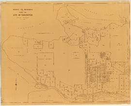
City of Vancouver, British Columbia

Plan of sea wall site, Main Street, and surrounding properties

Redevelopment plan for Jericho Department of National Defence lands

Vancouver, British Columbia

A preliminary proposal for development of Jericho Park

City of Vancouver, British Columbia

Vancouver, British Columbia : northerly portion, former City of Vancouver : major street plan

Area bounded by Kaslo St., 14th Ave., Renfrew St. and 18th Ave. : lands affected by proposed filling of Still Creek

Proposed zoning : comprehensive redevelopment areas

Key map showing proposed areas for partial and comprehensive redevelopment

Project 2, part of area "a" : pavements, curbs and sidewalks

Project 2, part of area "a" : plan of redevelopment

Project 2, part of area "a" : identification plan

Project 2, area "h" and part of "b" : existing gas, electricity and telephone

Project 2, area "h" and part of "b" : proposed property acquisitions project 2

Redevelopment project no. 2 area a-6, including existing blocks 72, 73, 87, 88, D.L. 196 : site plan and general location of utilities plan no. 3

City of North Vancouver zone map showing "use" and "set-back" restrictions
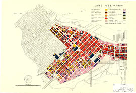
Land use - 1954

North-East Burnaby Study, revised Simon Fraser townsite plan : 1967 City of Vancouver alternative proposals
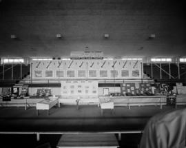
Vancouver Town Planning Commission display at P.N.E.

Proposed system of drainage and sewerage for False Creek and marginal areas
District lot boundaries within the City of Vancouver

Plan of District Lot boundaries. City of Vancouver, B.C.
![Map showing City of Vancouver, British Columbia [index map]](/uploads/r/null/a/f/b/afbf0b3832ff37e3af2c10d63547517135bca50be83ddddfcd25914b3c7b8f1d/6903af1e-3c6e-4577-9c0a-0967550524a7-LEG1153_142.jpg)
Map showing City of Vancouver, British Columbia [index map]

Interim harbour headline

Project 2, area "h" and part of "b" : pavements, curbs and sidewalks

Project 2, area "h" and part of "b" : existing utilities, water and sewer

Project 2, area "h" and part of "b" : plan of redevelopment

Project 2 : generalized plan of redevelopment

Project 2, part of area "a" : condition of buildings

Project 2, part of area "a" : plan of redevelopment

Part of area "a" : plan of redevelopment, Strathcona

Plan of the town of Newcastle, English Bay