Centennial project of Native Indians
- AM1052-: AM1052 P-1944
- Item
- [ca. 1960]
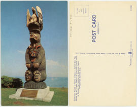
Item is a postcard printed with an image of the Salish Bear Pole at Qualicum Beach carved by Simon Charlie (Cowichan). .
199 results with digital objects Show results with digital objects
Centennial project of Native Indians
Item is a postcard printed with an image of the Salish Bear Pole at Qualicum Beach carved by Simon Charlie (Cowichan). .

Vancouver sheet, British Columbia
Part of City of Vancouver Archives technical and cartographic drawing collection
Item is a map of Vancouver Island and the southwest portion of mainland British Columbia from Bella Coola to Clinton, and south to New Westminster. Map shows geological, land district, and park boundaries; locations of mining recording offices and sub-offices; elevations in feet above sea level; mineral occurrences; and the development of geological formations by era.

![Dr. Brink describing lupin in meadow on V. I. [Vancouver Island] Long Beach](/uploads/r/null/c/4/0/c401962f5de8a041ad64242a33a168a420e8e797e227738666e55e032bb833d9/23e9ca56-f6a9-4d42-b2f1-85890a243cd9-2005-040_142.jpg)
Dr. Brink describing lupin in meadow on V. I. [Vancouver Island] Long Beach

Mrs. Stevenson & sea urchin, Victoria outer harbour


Part of William Orson Banfield fonds
![Myrtle [Kilpatrick] and Olive [Sadler]](/uploads/r/null/2/2/a/22ae0074631268708a81b2647fa6c6d3a6d893c4b3007dcb789a11087d7dae2b/da34a586-a84c-4bbb-8416-fde3ccbf6515-CVA289-003_142.jpg)
Myrtle [Kilpatrick] and Olive [Sadler]
Part of William Orson Banfield fonds
![West Coast trip [with Sherwood Lett, Arthur Lord, W.O. Banfield] : The picnic leaving the beach](/uploads/r/null/2/c/a/2caee8173fe25e1f11201a016da020341f0e7b41d8f2c5847af3cb033e85994e/542b242b-39ad-4112-b00c-dd96757f105a-CVA289-003_142.jpg)
West Coast trip [with Sherwood Lett, Arthur Lord, W.O. Banfield] : The picnic leaving the beach
Part of William Orson Banfield fonds
![West Coast trip [with Sherwood Lett, Arthur Lord, W.O. Banfield] : The "Bedouin" in Ril...](/uploads/r/null/0/3/5/035fa0a7507dbc91d4bb5fd635d88f7302bf09a91b80cc5e790885cff7d185cd/20a764f5-2a88-4039-a137-945598d04dc8-CVA289-003_142.jpg)
West Coast trip [with Sherwood Lett, Arthur Lord, W.O. Banfield] : The "Bedouin" in Riley's Cove
Part of William Orson Banfield fonds
![West Coast trip [with Sherwood Lett, Arthur Lord, W.O. Banfield] : The set complete, lifting the ...](/uploads/r/null/2/f/b/2fb07228d267632e04d07604b9bd34d8219abb57b2b2f08f1cb9d10adb521ca5/2b8db0f5-25df-4eaf-a0fb-6d99ce46baa1-CVA289-003_142.jpg)
Part of William Orson Banfield fonds
![West Coast trip [with Sherwood Lett, Arthur Lord, W.O. Banfield] : Gathering the net in](/uploads/r/null/e/3/a/e3a3366241397bc9fa4b40afe97704d1bbd555369f8f1bfa50123ec9a339ffe1/ce17d5fa-4a10-4d4c-94d3-590a1a246d62-CVA289-003_142.jpg)
West Coast trip [with Sherwood Lett, Arthur Lord, W.O. Banfield] : Gathering the net in
Part of William Orson Banfield fonds
![West Coast trip [with Sherwood Lett, Arthur Lord, W.O. Banfield] : Some of our catch](/uploads/r/null/3/0/0/30024c016d3fd6a5d456fad118d31feb2b9cd0ecb41b53587b9b8854a96275aa/0a6a75b2-df01-451e-b062-8fb498b1c76f-CVA289-003_142.jpg)
West Coast trip [with Sherwood Lett, Arthur Lord, W.O. Banfield] : Some of our catch
Part of William Orson Banfield fonds

Our picnic at the Goldstream, Easter
Part of William Orson Banfield fonds

Our picnic at the Goldstream, Easter
Part of William Orson Banfield fonds

The Gulf Islands from the Malahat
Part of William Orson Banfield fonds

Part of William Orson Banfield fonds
![C.M.A. [Canadian Manufacturing Association] : Victoria](/uploads/r/null/9/f/4/9f44ad3ca5ec39e585154c8bb586c1c61ac2aff86f016fae1e436c8c14a98c45/63326cd5-b0a6-41fe-9707-89f07abb4da5-CVA586-15088_142.jpg)
C.M.A. [Canadian Manufacturing Association] : Victoria
![C.M.A. [Canadian Manufacturing Association] : Victoria](/uploads/r/null/7/6/4/7649d620b2220fe37427cdc049baa5185217f1d4cd9e542e0db54bff3375cc15/a079bbb5-eb0b-41e8-a55a-2cf6f9abf8d8-CVA586-15091_142.jpg)
C.M.A. [Canadian Manufacturing Association] : Victoria
![C.M.A. [Canadian Manufacturing Association] : Victoria](/uploads/r/null/7/4/5/7454d053322bda9dc8bd2f861fdd42c11bb0fc3156f24b41b81742e87a104183/c684faef-2c78-4c44-ba5b-0125a5fabec1-CVA586-15093_142.jpg)
C.M.A. [Canadian Manufacturing Association] : Victoria
![C.M.A. [Canadian Manufacturing Association] : Victoria](/uploads/r/null/2/d/c/2dcd14464038199b8dd29dde84c572129750d77bf48a9770072aba2eef124305/46d8b41e-3560-4849-b839-226fdaa6684a-CVA586-15094_142.jpg)
C.M.A. [Canadian Manufacturing Association] : Victoria

Fairbridge Farm, Vancouver Island : farm scenes
Fairbridge Farm, Vancouver Island : farm scenes

Elk Falls : Vancouver Island operations : Comox

Elk Falls : Vancouver Island operations : Comox
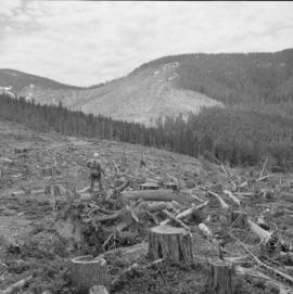
Comox Logging for Elk Falls Co. : Vancouver Island
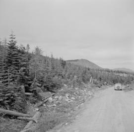
Comox Logging for Elk Falls Co. : Vancouver Island

Campbell River town site : aerial, rollie, streets


Elk Falls plant interiors : roll grinder


Elk Falls - Pacific Mills : personnel


Part of City of Vancouver Archives technical and cartographic drawing collection
Item is a sheet with 4 maps on recto and text on verso. The maps depict southwestern British Columbia; the information on the verso is predominantly statistics re: the province's economic development and tourism information for various towns and districts in the area.

Part of City of Vancouver Archives technical and cartographic drawing collection
Item is a map showing subdivisions of townships in Coquitlam, Port Moody, Pitt Meadows, Surrey, Langley, Sumas, Sardis and Chilliwack. The west coast of British Columbia from Burrard Inlet to the Sechelt peninsula is shown as well as Vancouver Island and the surrounding Gulf Islands. Trails, post offices and railway stations are included.
Part of City of Vancouver Archives technical and cartographic drawing collection
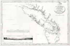
Map shows the discoveries made in 1792 on the north-west coast of North American by examining Juan de Fuca Strait and the corresponding navigable channels, prepared for Dionisio Galiano and Captain Valdes, naval captains of the Royal (Spanish) Fleet in the year 1795.

Vancouver Island and adjacent shores of British Columbia
Part of City of Vancouver Archives technical and cartographic drawing collection
![[View of] Little Qualicum Falls](/uploads/r/null/8/9/8923e2a2e8b20b1d3f1ee14f346adef7beac44890a81e0397e832b764c0d85ee/b668948b-23f2-4c30-bb79-b13735ec9955-A72040_142.jpg)
[View of] Little Qualicum Falls
Part of Karl Haspel fonds

Map no. 1 shewing Union Steamship Company route and ports of call : lower run
Item is a map showing ports of call along Vancouver Island and the southern coast of British Columbia from Smith Sound to Vancouver.

Map of south western British Columbia showing coastal lumber producers
Primary map shows lumber shippers and producers in the Lower Mainland and Vancouver Island. Inset maps show lumber shippers and producers in Greater Vancouver and the location of the primary map in relation to the rest of Canada.
![Going to [Mitlenatch Island]](/uploads/r/null/f/e/d/fed3a763e66009cfb8891b4f95035241216736342d267a32fea3f87c7f72d946/5f3248d6-b738-4c1d-b7f9-51b3a58bd94e-2005-040_142.jpg)


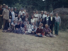
Nanoose Bay, May 1955 - Group on hill at Powder Point

Sea life seen at outer harbour Victoria