
Portrait of Alexander Godfrey (left) and Chris Godfrey
- AM169-F17-: CVA 162-01
- Item
- [ca. 1860]
Part of Alexander Godfrey fonds
Portrait of Alexander Godfrey (left) and Chris Godfrey
Part of Alexander Godfrey fonds

Part of City of Vancouver Archives technical and cartographic drawing collection
Item is a map showing the extent of the Canadian Pacific Railway Company (C.P.R.) in Canada in 1883. Map shows boundaries, roads, trails, telegraph lines, towns, rivers, lakes and mountainous terrain in British Columbia, the North West Territory (Alberta, Athabasca, Saskatchewan, Assiniboia), Manitoba and Kewaydin, as well as some of Ontario and Western Quebec. Map is folded inside a book titled "North West Territory, Canada."
![Crash on road [at] Mohawk](/uploads/r/null/0/a/d/0ada6c7891a043957b5aadbe2115a8d37cfff35944e1512046e2bb7796188bc4/a1b0e35f-73d0-4d68-82bc-8fcff8ec4951-CVA260-1931_142.jpg)
Part of James Crookall fonds
![Crash on road [at] Mohawk](/uploads/r/null/4/b/0/4b0f4083f05bc999218bbff1e7c5e7425d47ff930a975e1839907bd42fb7adab/0656671b-90dd-456d-80ff-63db499b6362-CVA260-1935_142.jpg)
Part of James Crookall fonds
![[Man on RAF motorcycle] Lonsdale](/uploads/r/null/c/9/8/c98a21c4c13b626a7bd1507fde8407cf532855a78a407e4edbac6934456e5da1/f6da8fee-fb45-453c-8df5-85180a530199-CVA260-1949_142.jpg)
[Man on RAF motorcycle] Lonsdale
Part of James Crookall fonds
Item is a photograph showing a man in uniform sitting on a motorbike and Marysville House is visible in the background.
![Lonsdale and Kingsford [statue]](/uploads/r/null/4/e/b/4eb5b7a942fc4a06365e37cc97e6411e21c582e7425cf90a87f4a34e54c8f8a3/2de34eb8-f245-44d5-b99a-0556e0077892-CVA260-1952_142.jpg)
Lonsdale and Kingsford [statue]
Part of James Crookall fonds

Part of James Crookall fonds
![[A building in] Leaside](/uploads/r/null/9/e/3/9e3282864db7212dea286a30bde5055d461122a39cd6d09fba9e841bf46438c6/f2d7e000-aab2-4c45-9f71-c81a9f234c98-CVA260-2013_142.jpg)
Part of James Crookall fonds

Part of James Crookall fonds

Part of James Crookall fonds
![Niagara [Falls]](/uploads/r/null/2/2/22620032287c20a25dd39ff1df72693ff24e25c17ff764f78155743349d10930/b5ca0824-8cf5-4347-904b-e2966e61f3e3-CVA7-335_142.jpg)
Part of James Luke Quiney fonds

Part of James Crookall fonds
Part of James Crookall fonds
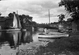
Item is a photograph showing several small boats including one named "Paridie" of Toronto.
![1 82nd crash near [Barracks] Mohawk](/uploads/r/null/4/e/7/4e76d041d6d4b1a1befc96342ff8f704dfe619b3c5f12788904bc8618ced1da2/38f32076-26ef-49a0-ae66-ef8b3b1c2aeb-CVA260-2211_142.jpg)
1 82nd crash near [Barracks] Mohawk
Part of James Crookall fonds
![1 Miller and [...?] "Flood"](/uploads/r/null/e/6/c/e6cfc33eb15738be20c429795fd0312bdf3323eda40d8084ddc81c09af83ec85/457c7633-a8c0-4ee2-b2f8-a53ac6fa47c3-CVA260-2215_142.jpg)
Part of James Crookall fonds

Part of James Crookall fonds

Mitchell crash, near Shannonville
Part of James Crookall fonds

Part of James Crookall fonds
Item is a photograph showing a crashed airplane and a boy carrying an armload of newspapers while standing on a railway track.
![Rest on [vouli] march [Fr. Smith]](/uploads/r/null/d/e/2/de220c78acd651b5f261420333b63c48a2205279f0e6cdfa8d1b8256937ebbfc/6744fc83-2ce5-45d4-99a2-1d4badb3eeb5-CVA260-2291_142.jpg)
Rest on [vouli] march [Fr. Smith]
Part of James Crookall fonds

Part of James Crookall fonds
![[Anderson] at Niagara](/uploads/r/null/c/9/6/c961d8fc49cfdc565d44a0176943a83630b1395cbd8d12a68dc32f47124e6808/7a09cd93-a3ee-407f-84d1-48f15f093ab4-CVA260-2307_142.jpg)
Part of James Crookall fonds

Part of James Crookall fonds
![Hangars, N. [north] Toronto](/uploads/r/null/0/b/1/0b12ecc4cf445db701c89c5c9ff138b79d81a400fd14d1983f2b7f4e5caa2c3e/37f5a721-de50-41f1-b867-6b0c6234dacd-CVA260-2310_142.jpg)
Part of James Crookall fonds
![[McIntdoe?] at Leaside](/uploads/r/null/6/4/7/647683dc2947c9eda45b78ec1206161188f8032b313378637b323d2eae3c805b/a19287fc-877c-446e-b382-7582a3b64151-CVA260-2312_142.jpg)
Part of James Crookall fonds

Landscape - detail : fence (Upper Canada Village)
![Landscape - detail : fence [Upper Canada Village]](/uploads/r/null/2/4/2479065e1dde1242fdf7554080854da1e0bb3b35ff2092ed7fbc13b3199bc19a/7248e352-c6ef-4af9-acc3-19899c0b4b7b-A54182_142.jpg)
Landscape - detail : fence [Upper Canada Village]
![Landscape - detail : root fence (U[pper] C[anada] V[illage])](/uploads/r/null/b/6/b6b2f6cee0bd23399f3796910dc62679b9f01f9de5951ed3c23acc28a066d927/1fa01913-68b5-481e-8173-c6212bd3501e-A54206_142.jpg)
Landscape - detail : root fence (U[pper] C[anada] V[illage])
![R[hododendron] : Vineland Flare R[oy] Forster Selection](/uploads/r/null/b/7/b75940f26beaad92743737b303f8dfa1940ca0be6e4b75b5aa2356d9a52fc1d9/a20d4d57-c25b-4e5b-a62c-8217c8c4667e-A57852_142.jpg)
R[hododendron] : Vineland Flare R[oy] Forster Selection
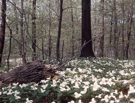
Trillium grandiflorum in Ontario
![[Rhododendron] impeditum [and] racemosum [and] R[hododendron] : Veesprite Pleris and Rhodos [at] ...](/uploads/r/null/b/e/be3c58cad75d920dc2cee0489fdb8d3a0efe0a5ba31fc6b78988dbc609a7f845/409dcb0b-d07f-4084-9a36-cf2981a8354b-A57884_142.jpg)

Part of L.D. Taylor family fonds
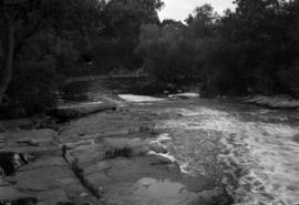
Photograph shows the railroad along the edge of Rainy Lake

Kakabeka Falls near Port Arthur, Ont., Height 170 feet
Part of Major Matthews collection

Red Sucker Trestle, from east side, North Shore
Part of Major Matthews collection
![[Gideon Robertson]](/uploads/r/null/e/e/eeadd8c81d9a76415cc3bab8228df826fb654ba448669eb0ae763a81fbd5e58b/74b41be5-f2ae-4137-ada4-9fffa5601059-A34730_142.jpg)
Part of Major Matthews collection
Head and shoulders portrait
![[Sir Sandford Fleming]](/uploads/r/null/1/2/12dc7712a9a6229d5caf7c7b1afbe2dcf7acff10a6328b94503b7252194cc61b/004cab06-a03f-4af4-b783-f7f2721e4ac2-A36012_142.jpg)
Part of Major Matthews collection

Grandfather and Grandmother Totten after their golden wedding
Part of Walter Hamilton fonds
Studio portrait
![[Dionne] Quintuplets [statues]](/uploads/r/null/1/2/12e42173417ff7d13ee29d293457139ed49ce1ba588909104faa9915c25a9c24/156bb8fb-cece-4661-8eda-13078e24d6b3-A06972_142.jpg)
[Dionne] Quintuplets [statues]


Sign on building shows Acadia farm.
![Crash on road [at] Mohawk](/uploads/r/null/8/4/3/8435748b694bc20a40d949e2f723c431be0b6bb62d896946cbc4cde9f6050c10/23e5573d-fed1-4c4a-a26b-dc3ac2579604-CVA260-1932_142.jpg)
Part of James Crookall fonds
![Hewitson's crash [at] Mohawk](/uploads/r/null/4/7/a/47ad5964f001f2c7461b5693c046484b1cc2b2797123b9c44c47c6795c801858/bf88edfb-2f34-4f3a-8618-e56e5288669f-CVA260-1965_142.jpg)
Part of James Crookall fonds
![[Motorcycle]](/uploads/r/null/a/a/6/aa622ab4699228f1ec89a9ef1190290fec1ef528da55cfd4ccca003d62a8c73b/6a35fef3-d412-437f-bac3-1b744d9f9ee2-CVA260-2048_142.jpg)
Part of James Crookall fonds
Item is a photograph showing a Harley-Davidson motorcycle with a sidecar. Motorcycle appears to be military style from around 1917.

Part of James Crookall fonds

Part of James Crookall fonds
Part of James Crookall fonds
![2 [Mr. Beding?] fields crash](/uploads/r/null/7/8/a/78a3481a876da813f427eeb6b46c126b91c526f2ff0c0788f2ae416f2a3b3c3a/f5a6c125-c666-4668-86bd-c18d31826b22-CVA260-2209_142.jpg)
Part of James Crookall fonds
![Self [James Crookall] and fire truck](/uploads/r/null/f/5/1/f51e3b8fa839c428ef64cd3a3f822e7c4402e2760e558738e4f344ce474d5694/4b8ee369-48df-41ba-aa14-c6b5e2581e71-CVA260-2214_142.jpg)
Self [James Crookall] and fire truck
Part of James Crookall fonds

Part of James Crookall fonds
![[James Crookall] and [Jim?] (Bulldog)](/uploads/r/null/d/b/0/db0be4b92771da69baedb1104d656f463f904a0f0758b0a5b80a7fe593352a8a/1a4134a8-d3ee-479a-99c0-204578d6acdf-CVA260-2219_142.jpg)
[James Crookall] and [Jim?] (Bulldog)
Part of James Crookall fonds

Part of James Crookall fonds