
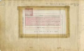
South Vancouver section 1 supplementary information
- COV-S167---: LEG1153.456-: LEG1153.456.087
- Part
- 1947
Part of City of Vancouver fonds
Part is a sheet showing assessment and other information relevant to South Vancouver section 1.
132 results with digital objects Show results with digital objects
South Vancouver section 1 supplementary information
Part of City of Vancouver fonds
Part is a sheet showing assessment and other information relevant to South Vancouver section 1.

Part of City of Vancouver fonds
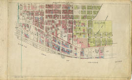
Part is a section depicting the area bounded by Fairmont Street to 27th Avenue to Dumfries Street to Thirty-seventh Avenue. The sheet has been extensively annotated, with colour coded areas to depict land use, status of lots as tax sale properties for sale, sewer and water lines, as well as other colour codes that are not noted on the legend at the front of the volume.

South Vancouver section 7 supplementary information
Part of City of Vancouver fonds
Part is a sheet showing assessment and other information relevant to South Vancouver section 7. The sheet also includes an attached overlay depicting revisions to lot numbering in the block bounded by Columbia Street to 45th Avenue to Alberta Street to 46th Avenue.

Part of City of Vancouver fonds
Part is a section depicting the area bounded by St. George Street to Thirty-seventh Avenue to Cambie Street to Forty-eighth Avenue. The sheet has been extensively annotated, with colour coded areas to depict land use, status of lots as tax sale properties for sale, sewer and water lines, as well as other colour codes that are not noted on the legend at the front of the volume.

South Vancouver section 8 supplementary information
Part of City of Vancouver fonds
Part is a sheet showing assessment and other information relevant to South Vancouver section 8.

Part of City of Vancouver fonds
Part is a section depicting the area bounded by Bruce Street to Thirty-fifth Avenue to Prince Edward Street to Forty-seventh Avenue. The sheet has been extensively annotated, with colour coded areas to depict land use, status of lots as tax sale properties for sale, sewer and water lines, as well as other colour codes that are not noted on the legend at the front of the volume.

Part of City of Vancouver fonds
Part is a section depicting the area bounded by Carlton Street to Thirty-seventh Avenue to Dumfries Street to Forty-eighth Avenue. The sheet has been extensively annotated, with colour coded areas to depict land use, status of lots as tax sale properties for sale, sewer and water lines, as well as other colour codes that are not noted on the legend at the front of the volume.

South Vancouver section 10 supplementary information
Part of City of Vancouver fonds
Part is a sheet showing assessment and other information relevant to South Vancouver section 10.

South Vancouver section 12 supplementary plans
Part of City of Vancouver fonds
Part is a group of overlays originally attached to sheet LEG1153.456.107. The overlays depict block revisions to the following: the block bounded by Dumfries Street, 58th Avenue, Knight Street and 59th Avenue; the area bounded by Argyle Street to 52nd Avenue to Fleming Street to 54th Avenue; the area bounded by Lanark Street to 51st Avenue to Knight Street to 54th Avenue; the block on the north side of 55th Avenue east of Knight Street; and parts of the block north of 53rd Avenue between Lanark Street and Dumfries Street.
South Vancouver section 13 supplementary information
Part of City of Vancouver fonds
Part is a sheet showing assessment and other information relevant to South Vancouver section 13. The sheet also includes an attached overlay depicting revisions to lot numbering in the block bounded by Carleton Street to 48th Avenue to Vivian Street to 49th Avenue (Blocks 9 & 10, N.W. 1/4 D.L. 337).

Part of City of Vancouver fonds
Part is a section depicting the area bounded by St. George Street to Marine Drive to east boundary ot DL. 319 to the Fraser River. The sheet has been extensively annotated, with colour coded areas to depict land use, status of lots as tax sale properties for sale, sewer and water lines, as well as other colour codes that are not noted on the legend at the front of the volume.

South Vancouver section 15 supplementary information-1
Part of City of Vancouver fonds
Part is a sheet showing assessment and other information relevant to South Vancouver section 15. The sheet also includes four attached overlays depicting block revisions in the following areas: the bock on the east side of Main Street between 62nd Avenue and 63rd Avenue; the block on the east side of Cambie Street between Marine Drive and 65th Avenue; lots along 60th Avenue and 61st Avenue between St. George Street and Prince Edward Street; and the block bounded by Prince Edward Street, 61st Avenue, Main Street and 62nd Avenue.

Part of City of Vancouver fonds

Part of City of Vancouver fonds

Part of City of Vancouver fonds

Part of City of Vancouver fonds

Part of City of Vancouver fonds

Part of City of Vancouver fonds

Part of City of Vancouver fonds

Part of City of Vancouver fonds

Part of City of Vancouver fonds

Part of City of Vancouver fonds
![Sheet No. 1 [Ontario Street to 16th Avenue to Cambie Street to 23rd Avenue]](/uploads/r/null/4/d/d/4dd3d21cd72c689cdfec84f31637e9a1c0960c1d2d6d15e3441fafba4e5c91ee/8198c61c-ff71-45ed-b5c5-3e2c8c212922-LEG1153_142.jpg)
Sheet No. 1 [Ontario Street to 16th Avenue to Cambie Street to 23rd Avenue]
Part of City of Vancouver fonds
![Sheet No. 5 [Ontario Street to Forty-fifth Avenue to Cambie Street to Forty-ninth Avenue]](/uploads/r/null/1/f/1/1f17e485ff8505c9ad9b4316c404cfff72e76d3f9918a678f98247b5281f765e/dd6f5950-270a-4467-b83f-26a0bc4752f4-LEG1153_142.jpg)
Sheet No. 5 [Ontario Street to Forty-fifth Avenue to Cambie Street to Forty-ninth Avenue]
Part of City of Vancouver fonds
![Sheet No. 8 [George Street to King Edward Avenue to Ontario Street to Thirtieth Avenue]](/uploads/r/null/f/0/7/f077d1dfb6f6da927e00bd6cd4e3944aba3ea7a93b1c2076a280a8e003fb7b59/c0c04996-4ae8-4163-bab7-7398e0b0942a-LEG1153_142.jpg)
Sheet No. 8 [George Street to King Edward Avenue to Ontario Street to Thirtieth Avenue]
Part of City of Vancouver fonds
![Sheet No. 9 [George Street to Thirtieth Avenue to Ontario Street to Thirty-eighth Avenue]](/uploads/r/null/c/8/c/c8c223273de73dd975de4d45feac09eec2dcfde8226aaa0e1b8f1426493a4389/bc29ee5f-42d7-4859-990c-c55084703959-LEG1153_142.jpg)
Sheet No. 9 [George Street to Thirtieth Avenue to Ontario Street to Thirty-eighth Avenue]
Part of City of Vancouver fonds
![Sheet No. 10 [George Street to Thirty-eighth Avenue to Ontario Street to Forty-fifth Avenue]](/uploads/r/null/c/7/b/c7b4c32e4e766f9f7bbb885b57274132350e9acb7f1ca1595e42ccb2424079e6/b422e91a-0aba-46ea-9c43-9684ffe01f17-LEG1153_142.jpg)
Sheet No. 10 [George Street to Thirty-eighth Avenue to Ontario Street to Forty-fifth Avenue]
Part of City of Vancouver fonds
![Sheet No. 16 [Elgin Street to Thirty-first Avenue to George Street to Thirty-seventh Avenue]](/uploads/r/null/6/9/5/695feca13c8efdfb42f0117089b336c5b716f9b46f34fd230b843586dc652633/b5bcc336-2de9-4410-9909-73df03c3ce64-LEG1153_142.jpg)
Sheet No. 16 [Elgin Street to Thirty-first Avenue to George Street to Thirty-seventh Avenue]
Part of City of Vancouver fonds
![Sheet No. 17 [Ross Street to Thirty-seventh Avenue to George Street to Forty-fifth Avenue]](/uploads/r/null/9/a/8/9a86378b20bae8e5ff7a19553904ecd0f0215f5011760aed5fd6800b4cb1229b/aef15833-fcfc-4f39-9147-8837c68fcf81-LEG1153_142.jpg)
Sheet No. 17 [Ross Street to Thirty-seventh Avenue to George Street to Forty-fifth Avenue]
Part of City of Vancouver fonds
![Sheet No. 38 [Dundee Street to Kingsway Avenue to Nanaimo Street to Forty-first Avenue]](/uploads/r/null/5/2/9/52963d94b3d53640e63b18df48d3cf38d6a4e213048f0b41c02a1dcfd1695ec0/955b099b-ddfb-4694-b03f-0954f0b7b4df-LEG1153_142.jpg)
Sheet No. 38 [Dundee Street to Kingsway Avenue to Nanaimo Street to Forty-first Avenue]
Part of City of Vancouver fonds
![Sheet No. 39 [Carlton Street to Forty-first Avenue to Nanaimo Street to Forty-eighth Avenue]](/uploads/r/null/d/5/e/d5e393f2166d9b7af78a6d4e999cc8e2574558679d5be4506435016449640c50/af107c2d-81ff-4512-8506-f4be16caafd4-LEG1153_142.jpg)
Sheet No. 39 [Carlton Street to Forty-first Avenue to Nanaimo Street to Forty-eighth Avenue]
Part of City of Vancouver fonds
![Sheet No. 41 [Carlton Street to Fifty-seventh Avenue to Nanaimo Street to Sixty-fifth Avenue]](/uploads/r/null/4/a/5/4a51356de1ddb79cb9aa5c6fc573bbbcf9640d4469550b5080b5981b049eace0/0ba2e77f-80d3-4101-84f9-df784bee297c-LEG1153_142.jpg)
Sheet No. 41 [Carlton Street to Fifty-seventh Avenue to Nanaimo Street to Sixty-fifth Avenue]
Part of City of Vancouver fonds
![Sheet No. 54 [Boundary Road to Fifty-eighth Avenue to Tyne Street to Sixty-sixth Avenue]](/uploads/r/null/4/9/2/4925e281903d682f1a68e9722289d297d3b67f69de4977aca839c40d77ac6c47/d1cab1e4-ba00-4e71-a0b0-055f4b10f9bb-LEG1153_142.jpg)
Sheet No. 54 [Boundary Road to Fifty-eighth Avenue to Tyne Street to Sixty-sixth Avenue]
Part of City of Vancouver fonds
![Sheet No. 55 [Boundary Road to Sixty-sixth Avenue to ca. Tyne Street to Fraser River]](/uploads/r/null/3/a/c/3ac8590cc5a2246cce9796841569265201d54e629168c61ff788739a6da3a3d7/87ee0a66-62dc-4480-a8a7-583ba87ea320-LEG1153_142.jpg)
Sheet No. 55 [Boundary Road to Sixty-sixth Avenue to ca. Tyne Street to Fraser River]
Part of City of Vancouver fonds
![Sheet No. 56 [Ontario Street to SW Marine Drive to Ash Street to Fraser River]](/uploads/r/null/1/9/8/19805cc3ca1a36e79b75812124f4d19bc1cba5d9c9a5cbfda7eb2e5d00efe39d/792d979d-2b3f-44fb-8739-651d77bbef08-LEG1153_142.jpg)
Sheet No. 56 [Ontario Street to SW Marine Drive to Ash Street to Fraser River]
Part of City of Vancouver fonds

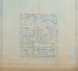
South Vancouver section 3 supplementary information
Part of City of Vancouver fonds
Part is a sheet showing assessment and other information relevant to South Vancouver section 3.

Part of City of Vancouver fonds
Part is a section depicting the area bounded by Welwyn/Argyle Street to King Edward Avenue to Prince Edward Street to 36th Avenue. The sheet has been extensively annotated, with colour coded areas to depict land use, status of lots as tax sale properties for sale, sewer and water lines, as well as other colour codes that are not noted on the legend at the front of the volume.

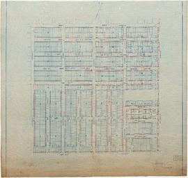
South Vancouver section 5 supplementary information
Part of City of Vancouver fonds
Part is a sheet showing assessment and other information relevant to South Vancouver section 5.

South Vancouver section 6 supplementary information
Part of City of Vancouver fonds
Part is a sheet showing assessment and other information relevant to South Vancouver section 6.

Part of City of Vancouver fonds
Part is a section depicting the area bounded by Boundary Road to Twenty-ninth Avenue to Earles Street to Foster Avenue. The sheet has been extensively annotated, with colour coded areas to depict land use, status of lots as tax sale properties for sale, sewer and water lines, as well as other colour codes that are not noted on the legend at the front of the volume.

South Vancouver section 9 supplementary information
Part of City of Vancouver fonds
Part is a sheet showing assessment and other information relevant to South Vancouver section 9. The sheet also includes three attached overlays depicting revisions to lot numbering in the following areas: the block on the west side of Clarendon Street between 42nd Avenue and 45th Avenue; the block on the east side of Chambers Street north of 38th Avenue; and the block on the north side of 42nd Avenue west of Wales Street.

South Vancouver section 15 supplementary information-2
Part of City of Vancouver fonds
Part is an overlay taped over top of one of the overlays on sheet LEG1153.465.113. This second lyaer of overlay depicts lot renumbering in the block of 63rd Avenue east of Ontario Street.

Part of City of Vancouver fonds
Part is a section depicting the area bounded by St. George Street to Fifty-ninth Avenue to Ash Street to the Vancouer and Lulu Island railway right-of-way. Note that this sheet overlaps the are covered by South Vancouver sheet 14. The sheet has been extensively annotated, with colour coded areas to depict land use, status of lots as tax sale properties for sale, sewer and water lines, as well as other colour codes that are not noted on the legend at the front of the volume.

Part of City of Vancouver fonds
Part is a section depicting the area bounded by Argyle Street to Fifty-eighth Avenue to St. George Street to the Fraser River. The sheet has been extensively annotated, with colour coded areas to depict land use, status of lots as tax sale properties for sale, sewer and water lines, as well as other colour codes that are not noted on the legend at the front of the volume.
Part of City of Vancouver fonds
Part is a section depicting the area bounded by Vivian Street to Sixty-second Avenue to Argyle Street to the Fraser River. The sheet has been extensively annotated, with colour coded areas to depict land use, status of lots as tax sale properties for sale, sewer and water lines, as well as other colour codes that are not noted on the legend at the front of the volume.
Part of City of Vancouver fonds

Part of City of Vancouver fonds
Part of City of Vancouver fonds

Part of City of Vancouver fonds

Part of City of Vancouver fonds