![[S.S. "Lady Alexandra"]](/uploads/r/null/7/4/e/74e87d22579d72c80b76610fb6a3083e0a77f35f8abf9edcf8901caa3937305e/0a29283e-c0ae-465f-b3c8-bc4c0e86379a-CVA374-95_142.jpg)
- AM75-S1-: CVA 374-95
- Item
- [between 1920 and 1939]
Oblique view
Oblique view
![[Upper passenger deck of either "Lady Cecilia" or "Lady Cynthia"]](/uploads/r/null/6/1/9/6196afdfb81937783e4b2caf72226df6616f2e1bf93bb8ed0462b87a37014750/7f89ce80-349d-416a-a8cd-cec4117488e0-CVA374-171_142.jpg)
[Upper passenger deck of either "Lady Cecilia" or "Lady Cynthia"]
![[View of unidentified resort area of Union Estates]](/uploads/r/null/2/e/0/2e03d30a9532a7b59f9a1bda0974b8db763508548579941882dfdb890041945c/79411a1f-303e-4bdb-af29-0eba3f6b9c08-CVA374-481_142.jpg)
[View of unidentified resort area of Union Estates]
![[Warship viewed from Coastal Steamer in] Queen Charlotte Strait B.C.](/uploads/r/null/d/1/a/d1a1232ec7f3649e597ad3c1110b0bbe7369aa213f8eedf71ee4c46d894741c2/bf0dddb3-0ed7-431a-9992-13dc39ec2e82-CVA374-246_142.jpg)
[Warship viewed from Coastal Steamer in] Queen Charlotte Strait B.C.
![Board of Trade Excursion on the P.G.E. [Pacific Great Eastern]](/uploads/r/null/2/5/3/253028f0a7e19caad09c12892abc302244da74b1727bbe629f8a06f25aab06e1/423124a8-95b4-465b-906c-b251c0063524-CVA374-186_142.jpg)
Board of Trade Excursion on the P.G.E. [Pacific Great Eastern]


Photograph shows a view looking south from deck of S.S. "Coquitlam"


Map no. 2 shewing Union Steamship Company route and ports of call : northern run
Item is a map showing ports of call along Haida Gwaii (Queen Charlotte Islands) and the northern coast of British Columbia from Stewart to Smith Sound.

Item is a map showing cities and towns, smaller settlements, post offices, railways, roadways, trading posts, ferries, hospitals, telegraph lines, government agents' offices, mining and sub-mining recording offices, falls and rapids, drainage flow, and park, provincial, and international boundaries. An inset map shows the southern Vancouver Island and Lower Mainland area in greater detail. Item includes road, rail, and coastal distance tables, lists of administrative offices and their locations, and an index of post offices.
![[Floating village from a ship]](/uploads/r/null/b/d/d/bdd8b871ae47efbd8809e7d515330aa97593f31f39bf76bb48bffd6fd23a6cb8/70281e6e-4000-413e-96fb-96e82f0679f0-CVA374-244_142.jpg)
[Floating village from a ship]
![[Floating village]](/uploads/r/null/3/4/6/346db92a826881787c29170756174220783e5796c1b2ed6ea90b9cfb7c31bbe6/d1cc1aac-5757-49f6-ba2d-427bc7d7a162-CVA374-245_142.jpg)
![[Howe Sound Ferries Ltd. Dispatcher's Office and Coffee Shop building at unidentified beach]](/uploads/r/null/0/d/1/0d1cc96cd976634087da4cedf8dcf4fce664751681e91f73b61b02fde6e094cb/7d85fce0-0a3d-47a0-be76-528890f58e0a-CVA374-362_142.jpg)
[Howe Sound Ferries Ltd. Dispatcher's Office and Coffee Shop building at unidentified beach]
![[Interior of wheel house on S.S. "Catala"]](/uploads/r/null/3/8/1/381e23111d52d0cb905cc02cce1414cbe2a1030d01db4a2f7441498ded909908/37678dab-2c6a-4e4d-aa54-42e88e71a8e5-CVA374-168_142.jpg)
[Interior of wheel house on S.S. "Catala"]
![[S.S. "Catala"]](/uploads/r/null/e/0/8/e0899a4926c2c1bbbb673a97636414caddb85881ad685b762b0ef3606ab102aa/0bec7baa-b3cd-4246-aaee-59a26e52a2bd-CVA374-24_142.jpg)
![[S.S. "Chilliwack" (II) at dock]](/uploads/r/null/2/6/f/26fbbe63d9ef32214d1a82f62eb3f47a4d3512f37f01fe1c6f5c586d8a7cbc22/fd5f1a0a-3397-4c7e-ad66-9d3e6b66080c-CVA374-56_142.jpg)
[S.S. "Chilliwack" (II) at dock]
![["Lady Cecilia" approaching float to pick up passengers]](/uploads/r/null/a/c/7/ac7847341267b5c11aea30c48e56bd6b7e9079d5be9857dbd47b164f1b3285e0/27d527d3-bfff-41c4-b20d-58cad637ea50-CVA374-174_142.jpg)
["Lady Cecilia" approaching float to pick up passengers]
![[A couple sitting on a bench overlooking the water towards the mountains]](/uploads/r/null/0/9/c/09c1b281fbd6e4c13dd3fb4fa8f00e2d857691ecc6be74ff1f4b54a9b50bbc89/5014652c-ce2a-4550-9079-cbc042fa80c6-CVA374-485_142.jpg)
[A couple sitting on a bench overlooking the water towards the mountains]
![[Aboard M.V. "Chilco"]](/uploads/r/null/1/2/b/12bb4b0d9b0fb2176cda033ee131ba6fbe76c6c3efc323ceb53cf0cde624d15d/3105ffe8-778c-44da-8341-3c389b50439d-CVA374-255_142.jpg)
Photograph shows William Gardiner, Chief Steward
![[Dockside scene at unidentified wharf]](/uploads/r/null/5/3/e/53e66fb6a08a9bd32705b519330faae7cd9c1a844632f1f09dbb4e0f1444496b/0dc3f8b8-742a-4ad9-9701-ff775e218d7c-CVA374-164_142.jpg)
[Dockside scene at unidentified wharf]

![[Gerald Rushton; J. Douglas Dingwall, Chief Ticket Agent; unidentified crewman; Capt. H.E. Lawrey]](/uploads/r/null/e/b/a/eba81127f24acb65e8b275527d2484a60e4bae35a7aa05f113aa9092b77d3daa/dadb9fe5-a022-4407-bc81-21c88025f659-CVA374-285_142.jpg)
[Gerald Rushton; J. Douglas Dingwall, Chief Ticket Agent; unidentified crewman; Capt. H.E. Lawrey]

[Howe Sound Ferries Ltd. ferries: "Chilco", "Bowen", "Chasina" and "Island Flyer" at dock]

[Howe Sound Ferries Ltd. ferries: "Island Flyer", "Chasina", "Chilco" and "Bowen"]
![[S.S. "Cheam" on Howe Sound Excursion Service]](/uploads/r/null/d/6/0/d60293b7d80a86f11c8e8deff4116df64f95ed9a851a4620394c175d1da8afe3/15cefeeb-b8d9-45c9-93ad-fd73344823ea-CVA374-138_142.jpg)
[S.S. "Cheam" on Howe Sound Excursion Service]
![[S.S. "Lady Alexandra"]](/uploads/r/null/6/2/9/629c61730ba93aebf4e46ce7d9fdd83f7f73f931af3af6cc8c7c545b559b05d4/39a64a9f-c6fa-4d04-a1b3-95333b270700-CVA374-93_142.jpg)
Oblique view
![[S.S. "Venture" (possibly in Rivers Inlet)]](/uploads/r/null/7/c/c/7cc1ceb6787d5f33bf536a58283853249a7cee122012e48727bad6c8eeca559f/2faebb8d-bbf1-4729-ac9b-515e17ea37d7-CVA374-136_142.jpg)
[S.S. "Venture" (possibly in Rivers Inlet)]

![[View from bridge, aft along upper deck - S.S. "Lady Cecilia"]](/uploads/r/null/7/3/6/736ccdae019dacf794a37650bbd7cc83cb93c7843663fa84f5cbe5952986a151/32355a1b-e9c3-479a-8c8c-880711423355-CVA374-104_142.jpg)
[View from bridge, aft along upper deck - S.S. "Lady Cecilia"]
![[View of] Portland Canal, B.C. [from aboard a ship]](/uploads/r/null/7/c/b/7cb9a03a807eac9f15c01627c267838d6417bc9dd5b5259d209d87212c3c0e61/40969840-20e1-419f-a176-eb4ece7b7e28-CVA374-232_142.jpg)
[View of] Portland Canal, B.C. [from aboard a ship]

Building a Davis Raft at Cumshewa Inlet

Cottages of the Union Estates Ltd.
Photograph shows twelve buildings at Sechelt, Selm and Bowen Island

Fred Herlevsen, Manager, Evergreen Park Resort
Head and shoulders portrait
![Indian woman [doing laundry at] Charles Creek, Kingcombe Inlet](/uploads/r/null/5/6/8/56830c914b00af81119e540345fab65ab35c94688b642229c439f67baa57ff12/66384637-9d76-4371-82b0-204843a5dc5a-CVA374-208_142.jpg)
Indian woman [doing laundry at] Charles Creek, Kingcombe Inlet
Photograph shows a dug-out canoe


Union Steamships Limited : ports of call : cargo and passenger routes
Item is a map showing ports of call along the British Columbia coast.

Map no. 1 shewing Union Steamship Company route and ports of call : lower run
Item is a map showing ports of call along Vancouver Island and the southern coast of British Columbia from Smith Sound to Vancouver.
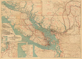
Part contains a commercial and visitors map of the southwestern land districts of British Columbia, encompassing Vancouver Island and the mainland from Seymour Inlet in the northwest to Black Pines in the northeast, extending south to Chiwaukum, Washington. Primary map shows settlements, government agent offices, mining and sub-mining recording offices, game reserves, customs posts, hospitals, ferries, campsites, golf courses, canneries, commercial air harbours, lighthouses, radio stations, motor boat refill stations, power sites, railways, roadways, trails, telegraph and telephone lines, steamship routes, topographic contour lines, and locations of falls and rapids. Text on the map provides information on land features and the presence of wild and farmed animals, and indicates current and possbile agricultural and industrial land use. Inset maps show the northern tip of Vancouver Island, Triangle Island and West and East Haycock Islands, and northwestern Washington State from Seattle to Centralia. A key map shows the location of the area covered by the main map in relation to the rest of North America.

South western British Columbia
Item is a map of southwestern British Columbia and northwestern Washington showing cities, municipalities, and settlements, post offices, government agents, railways, roads, ferry and steamship routes, air and seaplane ports, parks, campsites, glaciers, customs ports of entry, and elevations of mountains. Inset maps show the islands north of Cape Scott and the Seattle region. An small key map shows the primary map's location in relation to the rest of British Columbia and other maps published in the same series.

Preliminary map : Stikine River
Item is a map of the Stikine River region from Dease Lake in the north to Stewart in the south. Map shows land and timber surveys, government and First Nations reserves, mining division and international boundaries, government agents' offices, mining and sub-mining recording offices, post offices, villages, Hudson's Bay Company posts, telegraph lines, hospitals, schools, radio stations, triangulation stations, railways, roadways, bridges, falls and rapids, glaciers, and topographic contours.
![["Lady Cecilia" at dock]](/uploads/r/null/f/0/8/f0859fad94e556ebfb4ddaeb3622d4e5e09b3a3186f32eb45a7bf6bee09d9322/b3314b28-5f18-4314-9d88-cea1e0cf00d8-CVA374-103_142.jpg)
Photograph shows foredeck details
![[M.S. "Bowen" (Howe Sound Ferries Ltd.)]](/uploads/r/null/e/f/8/ef8d96dbf32e4b9784ef30aef0c823b46339a211846be90cb0ef6b6219bc5fa4/fd19ff98-99d5-45a8-84b1-a8e65e5e75e5-CVA374-130_142.jpg)
[M.S. "Bowen" (Howe Sound Ferries Ltd.)]
![[S.S. "Chilcotin" on summer cruise service to north coast of B.C. and Alaska]](/uploads/r/null/7/e/2/7e2db9210f464ac3dadc0c92c787f2be94279772e1db8d40cbb4c64b3700e70a/71b70ec3-e01f-4b9b-913d-4ce061f2543d-CVA374-40_142.jpg)
[S.S. "Chilcotin" on summer cruise service to north coast of B.C. and Alaska]
![[S.S. "Chilliwack (II) showing scows alongside transferring cargo]](/uploads/r/null/3/0/2/302f44c53fd8e47105f05e4c74dc895178fb7f72dd6d78c5eb4044ff493b1737/713524f8-1293-4ee0-b881-19f4c53330ca-CVA374-55_142.jpg)
[S.S. "Chilliwack (II) showing scows alongside transferring cargo]
![[Steamer "Capilano" (II) leaving Island Dock]](/uploads/r/null/d/1/d/d1d07abcb13b03d7727b8fd0ec6b91acd72ef0b1cc53cb9be31c217a48694a14/4d6f2231-8701-460c-a716-5f2fccec1feb-CVA374-7_142.jpg)
[Steamer "Capilano" (II) leaving Island Dock]
![[Unidentified men at restaurant table]](/uploads/r/null/a/5/2/a5253fe25d61d5d3dfc4df1a41dfc20effe5c92b444a7dbf9e538a559e72a847/ae245b1f-9432-4609-a713-f81bb91c9bb7-CVA374-297_142.jpg)
[Unidentified men at restaurant table]
![[Unidentified officer and passenger (possibly Mrs. Elsie Halterman) on deck of Union Steamer]](/uploads/r/null/0/9/d/09d1ed97a157d975937441fdb24ccf65064dc9f69b6a7f361330c7c47c30411e/b07d5bb1-8b7f-4e25-b744-2d1bf4c96f80-CVA374-295_142.jpg)
[Unidentified officer and passenger (possibly Mrs. Elsie Halterman) on deck of Union Steamer]
![[View across Kwatna Inlet off Burke Channel through a porthole of S.S. "Cardena"]](/uploads/r/null/0/6/e/06e3019f98bc530acf0339fd8305b91e86b7c28c1612abc73d2b13f99bbcdbff/c3628123-2448-459b-a69b-f2f26c60a081-CVA374-214_142.jpg)
[View across Kwatna Inlet off Burke Channel through a porthole of S.S. "Cardena"]

