
- COV-S632-: CVA 789-27
- Item
- Aug. 4, 1915
Part of City of Vancouver fonds
Part of City of Vancouver fonds
![Capilano [Creek] looking upstream from north part of island](/uploads/r/null/a/8/a896dc9c2db3c65159f7e2771c98e330ea3c12b91907157c4698e756dbb1826c/b3e6f5a4-4ff6-456c-84bb-263e82325018-A16531_142.jpg)
Capilano [Creek] looking upstream from north part of island
Part of City of Vancouver fonds
![Capilano [Creek] West Channel looking upstream from lower end](/uploads/r/null/1/1/119d1142158a2f8850f1a5e9d3775af1d6018a3291f1f2d51ee974cad3d03416/ddc2b9d6-276b-4887-9393-165796e72cef-A16533_142.jpg)
Capilano [Creek] West Channel looking upstream from lower end
Part of City of Vancouver fonds
![Capilano [River, North] Vancouver](/uploads/r/null/b/7/8/b78f57de17b47bbf531dea7db195235106f1f013de317beed5b8eb10555fab17/2b4d30b1-c99e-4816-8445-60c44448e68c-CVA312-02_142.jpg)
Capilano [River, North] Vancouver
![[Children standing on bridge at] Capilano](/uploads/r/null/b/0/1/b014969ad29bb674ee65ec3b3ff108d57b69782402647cb0bb2cd10a92261979/1f44383a-8c97-4ad8-898d-ebb8998589fa-CVA312-12_142.jpg)
[Children standing on bridge at] Capilano
![[St. Paul's] Catholic Church, North Vancouver](/uploads/r/null/a/9/d/a9d5e679046c5ce5a937351cb63e47b4a8e08a01326e5465b62084fd9df6184d/ffcc2ca5-6132-41ba-aefc-3ac320460151-CVA312-24_142.jpg)
[St. Paul's] Catholic Church, North Vancouver


Capilano River and Suspension Bridge

Tram going across the Capilano River at the dam site; Lions' in the distance

Item is a photograph showing Chief Joe Mathias shaking hands with a young child. Annotation on verso: "Donated by Mrs. F.M. Bland, 1964."

Chief Mathias of Capilano with Grey Eagle
Item is a photograph showing Chief Joe Mathias of Capilano with Grey Eagle and three others. Annotation on verso: "Donated by Mrs. F.M. Bland, 1964."

Item is a photograph of the wishing well at the suspension bridge in Capilano Canyon. The well is flanked with unpainted statues, a male, a female, and three children. The well is decorated with first nations style art and the sign reads "The Old Indian Wishing Well of Capilano".
![Group on barge [(Transfer No. 2)including Carl and the Captain]](/uploads/r/null/9/7/9735730d81fed89a00747f3c1a819f5b3035ab3becbcaa10119d63504cb40135/b5445b2f-c4a2-4f8e-82bb-2142e654938d-A43632_142.jpg)
Group on barge [(Transfer No. 2)including Carl and the Captain]
Group portrait

CAA-AAA-Approved Ranch Motel : Marine Drive and Capilano Road, North Vancouver, B.C.
Item is a postcard showing the Ranch Motel in North Vancouver. Caption on back of photograph: "On the beautiful North Shore. Centre to all scenic panoramas. 7 minutes to city centre over Lions Gate Bridge. 48 modern units (some kitchens) heated pool, coffee shop. The back of the postcard includes personal correspondence addressed to Mr. and Mrs. A. Mortander.
Cypress Canyon, North Vancouver, B.C.

Capilano Canyon and flume, Vancouver, B.C.

Target practice in the woods off Indian River Road, North Vancouver; Greenwood Archers

Suspension Bridge, Capilano Canyon, 200 feet high : Vancouver, B.C.

Bridge crossing Capilano Canyon, North Vancouver, B.C.
This postcard includes personal correspondence. Sent to Mrs. Harrison of Montreal, Quebec.

North Vancouver, B.C. - City Hall
This postcard includes personal correspondence. Sent to Miss G. Barnes of Mount Pleasant, Vancouver, B.C.
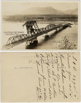
Second Narrows Bridge, Vancouver, B.C. Opened November 7th, 1925

Second Narrows Bridge, Vancouver, British Columbia
Item is a postcard printed with an image of the Second Narrows Bridge over Burrard Inlet. The vantage point is to the southeast of the bridge. The bridge is pictured in the process of opening.

Suspension bridge, Lynn Canyon, Vancouver, B.C.

Capilano Canyon and flume, Vancouver, B.C.
This postcard includes personal correspondence. Sent to Mr. A. Brown, care of M.W. Brown, Volta, California.

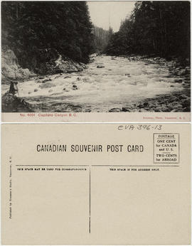
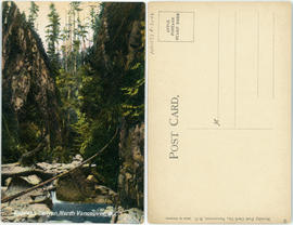
Capilano Canyon, near Vancouver B.C.

Capilano Canyon, Vancouver, B.C. (Canada)


Capilano Suspension Bridge, Capilano Canyon, B.C.

Capilano Suspension Bridge, length 450 ft., height 230 ft. Vancouver, B.C., Canada

Capilano Valley & the Lions, North Vancouver, B.C.

Capilano Valley and the "Lions," Vancouver, B.C.

First Capilano Canyon Suspension Bridge, height 200 ft., length 450 ft., Vancouver, B.C. Canada.

Fishing on the Capilano River, near Vancouver, B.C.

Map of portion New Westminster District
Part of City of Vancouver Archives technical and cartographic drawing collection
Item is a heavily-amended copy of a map illustrating intended land settlement and subdivision in 1877 in the future sites of Vancouver, Burnaby and the North Shore, from an area bordering on English Bay to an area bordering on North Arm. Also shown are bodies of water, Hastings & Granville Road, and the settlements of Hastings and Granville. Annotations by J.S. Matthews in 1954 made on the copy are tracings in white pen and darkening the background to improve the copy.
![Plate 163 [Key Plan of North Vancouver]](/uploads/r/null/e/1/d/e1d59c4aba0a20f0522dd57d1ecfbcc6fa0e15d2cb581616d819932b7b4485b7/be98b40c-82d0-4d47-97d2-e5bc54e3e904-1974-100_142.jpg)
Plate 163 [Key Plan of North Vancouver]
Part of City of Vancouver Archives technical and cartographic drawing collection
![Plate 164 [Lonsdale Avenue to Second Street to Chesterfield Avenue to Burrard Inlet]](/uploads/r/null/b/c/5/bc5801cb1cab9f718c08d5e85247acf3c6c6d41621bd633be9636327b722a9cd/db55d2fa-bc36-4407-a98b-9c062774aa12-1974-100_142.jpg)
Plate 164 [Lonsdale Avenue to Second Street to Chesterfield Avenue to Burrard Inlet]
Part of City of Vancouver Archives technical and cartographic drawing collection
![[Clearing the road after the Seymour Creek washout]](/uploads/r/null/f/c/fc6cfe672265e867d583e925ffa6c0fd3a92c7305bcba121a6f71a099afd83a8/56561df4-6b84-4fc0-b5c1-6523edbfeb84-A33580_142.jpg)
[Clearing the road after the Seymour Creek washout]
Part of Major Matthews collection
![[Construction of reservoir at Burwell Lake]](/uploads/r/null/0/9/09c494c0b883a3802afc29a5e0bfc8fad1ac3d712e98b1752cd982e0e7fbba5a/e7e4cb28-28df-4157-8e36-7b99bd5469da-A09314_142.jpg)
[Construction of reservoir at Burwell Lake]
Part of Major Matthews collection
![[Construction of reservoir at Burwell Lake]](/uploads/r/null/4/1/41b1e914a992698a666e1d324c08055e61e7e87450fe7023e1739d2104827b24/83bb7367-b7ef-4bbb-85d2-82a6f3fd608e-A09315_142.jpg)
[Construction of reservoir at Burwell Lake]
Part of Major Matthews collection
![[Construction of reservoir at Burwell Lake]](/uploads/r/null/7/7/7786039fc4e1c663927bd33feba77389488d28e353a4030d15f3eea0e1a4b468/f296699c-b70d-4760-8bb2-ca669d9a76fc-A09319_142.jpg)
[Construction of reservoir at Burwell Lake]
Part of Major Matthews collection
![[Construction of reservoir at Burwell Lake]](/uploads/r/null/5/d/5d3eb3f1bd505c6d220057e12b921c693540398850bda204a6a8d104d3246071/6901d2e1-572e-44dd-bc4d-126bb3859d8a-A09321_142.jpg)
[Construction of reservoir at Burwell Lake]
Part of Major Matthews collection

Bill McGuigan and three friends at Grouse Mountain
Part of McGuigan family fonds
![[Ferry line-up on Lonsdale Ave.]](/uploads/r/null/5/c/5c8eff95868920550dde6725bdf16b8ff7e523a1e2c2089aa09d9326bf74e691/0f1bd0ab-7225-4f8c-8bb4-78309ac87686-A24500_142.jpg)
[Ferry line-up on Lonsdale Ave.]
Part of Major Matthews collection
![[Ferry line-up on Lonsdale Avenue up to Eighth Street]](/uploads/r/null/0/7/07c1d194551657a593def712e867cd96259b6e82559677fc17d0b3c0ceceb28d/88726415-08cd-4424-9062-15ff90ff2cdf-A24499_142.jpg)
[Ferry line-up on Lonsdale Avenue up to Eighth Street]
Part of Major Matthews collection
![[Fifteenth Street looking east towards Grand Boulevard]](/uploads/r/null/7/3/73a89135f77f03c2170bc52234ba67e4d5b33dd68391be03e9ca3753fb8abd65/1332756e-55c4-4d2a-93f8-9e02d7c4bc28-A33961_142.jpg)
[Fifteenth Street looking east towards Grand Boulevard]
Part of Major Matthews collection
![[Fred Hicklenton, W.J. McGuigan, James McGeer and unidentified boy on Grouse Mountain]](/uploads/r/null/2/8/28b588272bf0ab82578cc05f6162c654be9eac77e4c2b9c56b6816393d40ab02/0be94fa6-3b6f-4560-8bd7-a041b3d8ac32-A32831_142.jpg)
[Fred Hicklenton, W.J. McGuigan, James McGeer and unidentified boy on Grouse Mountain]
Part of Major Matthews collection
![[Water system at Burwell Lake]](/uploads/r/null/2/7/9/279dc4809a615465d8340864db760b573ee6165405b7f7f455028d1604266087/71276c87-a294-4c13-9d87-8a3023d1e0fe-PANP66_142.jpg)
[Water system at Burwell Lake]
Part of Major Matthews collection
Item is a panorama print created from negatives Mount N38.1 (left side) and Mount N38.2 (right side).

Part of Major Matthews collection
The map is a draft of MAP 56.01, "Indian villages and landmarks, Burrard Inlet and English Bay, before the whiteman came." It shows the geographic area bounded by the north shore of Burrard Inlet, the Freaser River, Point Atkinson, and the Burrard Inlet Second Narrows. Shown on the map are locations of First Nations and European settlements, streams, coastal features, and inland vegitation. Physical features are labeled using both First Nations and European place names.

Draft map of Indian villages and landmarks, Burrard Inlet and English Bay, before the whiteman came
Part of Major Matthews collection
The map is a draft of map 56.01, "Indian villages and landmarks, Burrard Inlet and English Bay, before the whiteman came." It shows the geographic area bounded by the north shore of Burrard Inlet, the Fraser River, Point Atkinson, and the Burrard Inlet Second Narrows. Shown on the map are coastal sites labeled with First Nations place names.