![[The Narvaez Pageant at Ambleside Park]](/uploads/r/null/3/d/3de2065016b2fd82ae9271c4eae298d8566e6b8c351750ddcfe64a26b6d6872d/dd4e5ea8-0eb8-47eb-a2ff-d2b1ee90e35a-A34857_142.jpg)
[The Narvaez Pageant at Ambleside Park]
- AM54-S4-: Port P615.1
- Item
- Aug. 16, 1941
Part of Major Matthews collection
Photograph shows a re-enactment of First Nations awaiting European sailors to come ashore
447 results with digital objects Show results with digital objects
[The Narvaez Pageant at Ambleside Park]
Part of Major Matthews collection
Photograph shows a re-enactment of First Nations awaiting European sailors to come ashore
![[The second Point Atkinson Lighthouse]](/uploads/r/null/b/9/b9e177ee1ce9f57b4511f889b52cdc17371e5c62bd8436b25100c835f3ff9f3b/ebb69d73-121f-4ef6-a07e-0f59ccc800db-A33178_142.jpg)
[The second Point Atkinson Lighthouse]
Part of Major Matthews collection
![[View from Marine Drive towards Vancouver]](/uploads/r/null/e/c/ec0a1e1e85feff28cb2d7ddbb85f5f9deea09b78ce9cb426dc4739984502014a/28407251-577d-44cc-9e49-154a515647cd-A26744_142.jpg)
[View from Marine Drive towards Vancouver]
Part of Major Matthews collection
Photograph shows Mount Baker
![[View of Howe Sound from the Whytecliff Hotel]](/uploads/r/null/b/b/bb0d9e67af7bce182cff0e27ba40bcf503dcf795d6093c8cf03285eda539fa67/7b8d3202-94de-4e8b-9815-480c52649b3e-A33253_142.jpg)
[View of Howe Sound from the Whytecliff Hotel]
Part of Major Matthews collection
Photograph shows Gambier Island, Hood Point and Bowen Island
![[View of Howe Sound from West Vancouver showing Hood Point, Bowyer Island and Whytecliffe]](/uploads/r/null/6/7/67562932d73e81a1eb4649431864ce783f7c20df7f3d066a345c0d5240f3f4ea/c298f1e1-fb66-4e56-8bcb-11686ae38da7-A09918_142.jpg)
[View of Howe Sound from West Vancouver showing Hood Point, Bowyer Island and Whytecliffe]
Part of Major Matthews collection
![[View of Howe Sound from West Vancouver]](/uploads/r/null/4/e/4e434b4da0159b0f9ddcc19828bf72e262bf6d490874b5b2ff13bc89ca870a41/241ac1d5-a75f-44bb-87e5-0a9a8802d021-A09920_142.jpg)
[View of Howe Sound from West Vancouver]
Part of Major Matthews collection
![[View of Larson Bay looking south toward Batchelor Point]](/uploads/r/null/b/1/b1f13b8d6c2c0c3cb96ae766a3b020f9022423e3244d6c98571e008ef63f1e1f/4bd56f08-19ff-418f-996d-341cdeee0fc7-A09914_142.jpg)
[View of Larson Bay looking south toward Batchelor Point]
Part of Major Matthews collection
![[The Lions and Capilano Valley]](/uploads/r/null/7/b/7baa8f5e442aed64b1ed2ab832f6728be62b438b0a2ace950a48c5243cc039ec/1308622a-f187-4995-a9c8-73018b1b61ff-A09272_142.jpg)
[The Lions and Capilano Valley]
Part of Major Matthews collection
Gertrude Lawson House, [680 17th Street] West Vancouver [B.C.]
Part of Robin Ward fonds
Now the West Vancouver Museum and Archives.
![[Aerial view of] Horseshoe Bay, B.C.](/uploads/r/null/8/b/8b6ef59aac19a998092b2943027303676d0dfa0a9385846b7f5b9d0b84dc71e6/efc630d4-f812-4b57-803e-42a6bd292a9b-A02665_142.jpg)
[Aerial view of] Horseshoe Bay, B.C.
Photograph shows the dock, shoreline, and surrounding trees at Horseshoe Bay.
![Pleurotus porrigens : angel wing [at] Hollyburn](/uploads/r/null/1/6/1606705696b42e29e83020305a35da29a5cd5ee45bfe81b92002648fc5042bde/cac97102-1bc2-42ae-8150-d8c74ee3ae44-A57102_142.jpg)
Pleurotus porrigens : angel wing [at] Hollyburn

Mycology group at Hollyburn, Dr. Bandoni
Bliss Carman in West Vancouver
Part of Vancouver Poetry Society fonds
![[Point Atkinson Lighthouse, West Vancouver, B.C.]](/uploads/r/null/8/1/0/810ea423294b64b722f9557bc340cde9dd009bca5f1f42e6203130d3e038b28e/8eb82af4-c24c-4872-98ec-b839cfb7ae51-AM1052P-847_142.jpg)
[Point Atkinson Lighthouse, West Vancouver, B.C.]
![C.P.R. Princess Patricia[.] On triangle run between Seattle, U.S.A., Victoria and Vancouver, Canada.](/uploads/r/null/f/b/7/fb7441754f9fc1d275437a1d5193eb3118f843dff409135ac47ec5582f404c41/44aaa029-cad1-4e68-b7d1-9cec0fbe7e7b-AM1052P-153_142.jpg)
C.P.R. Princess Patricia[.] On triangle run between Seattle, U.S.A., Victoria and Vancouver, Canada.
Item is a postcard printed with an image of the Princess Patricia, one of the Canadian Pacific Railway Company's coastal service steamships, passing under the Lions Gate Bridge.

Item is a postcard printed with an image of the Lions Gate Bridge at nightfall, viewed from Stanley Park and looking north toward West Vancouver.
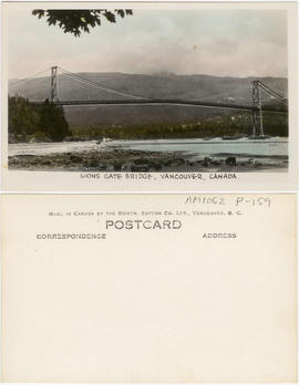
Lions Gate Bridge, Vancouver, Canada
Item is a postcard printed with an image of the Lions Gate Bridge and West Vancouver as viewed from a point near Lumberman's Arch in Stanley Park. The seawall around Stanley Park is shown in the lower left corner of the image.
Vancouver Ski Club Headquarters Hollyburn Mountain
Cottages to community : the story of West Vancouver's neighbourhoods

Part of Major Matthews collection

Part of Major Matthews collection

![[Looking south at the undeveloped British Pacific Properties]](/uploads/r/null/6/5/65f8722b97085517c0cd2ec4aa1c748b6f2f9e371c28f8eed6a5fa7e965a95cd/fcd2fc12-d909-4bcb-8757-be64af017b25-A43270_142.jpg)
[Looking south at the undeveloped British Pacific Properties]
Part of Major Matthews collection
Photograph shows the Lion's Gate Bridge and Vancouver in the background
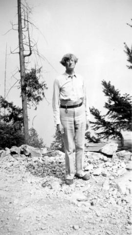
![[J. Ollason, Esq.]](/uploads/r/null/d/0/d00e772f32c8c655049a027ac6fc9d58dd76454999952e1c146aea51a3bdec14/52fc4ed8-9f82-4bd3-a03f-c9266d1e0a17-A34577_142.jpg)
Part of Major Matthews collection
Head and shoulders portrait
![[John Innes and his nephew]](/uploads/r/null/f/f/ff33025b6cd0e947da62214fa57f61343479a220b9206aedf68e4da1497067ae/f681be3f-d469-43cb-8584-823581436c3c-A35561_142.jpg)
Part of Major Matthews collection

Part of Major Matthews collection
![[Gleneagles Golf Course]](/uploads/r/null/d/4/d4d0e1fc68956df6eb61f767b03682c6bac7a324c42e60874f1d8e798ed15a45/ce4075ce-a8a5-413f-8374-b5cc0a6dd604-A09910_142.jpg)
Part of Major Matthews collection
Photograph shows area formerly part of Larson's Ranch.
![[Fisherman's Cove and Passage Island]](/uploads/r/null/a/1/a119ccfaf37b9076523c271a5be890b054a0c31d405ea13b3174c2cc2db87f68/672a9b2b-44aa-465c-bf52-b14d00a78028-A09900_142.jpg)
[Fisherman's Cove and Passage Island]
Part of Major Matthews collection
Photograph shows refreshment stand, dock and boats for hire at Fisherman's Cove with a view of Passage Island to the west. Construction of Marine Drive started in background.
![[Fisherman's Cove in Eagle Harbour]](/uploads/r/null/e/d/ed75d429d432902ab0a36d0d6a9c5c54c2af46d48fd76303adadfa20588cffe2/0d497ad1-6d05-412f-92a6-98d476dcb6c3-A33446_142.jpg)
[Fisherman's Cove in Eagle Harbour]
Part of Major Matthews collection
![[Francis William Caulfield outside the pilot house]](/uploads/r/null/1/e/1ead86849aaa40f10193b6e4317686d6cfa55dcfd34fbc45397ed0c8f00eee3b/338512e2-d4c8-4dde-91da-7c1d60a2f301-A35994_142.jpg)
[Francis William Caulfield outside the pilot house]
Part of Major Matthews collection
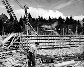
Concrete foundations of North Shore bridge-cable anchorage, sunk to a depth of thirty-five feet.
Part of Major Matthews collection

Part of Major Matthews collection
![North shore slash from old P.G.E. [Pacific Great Eastern Railway] tracks looking towards Marine D...](/uploads/r/null/0/e/0e1127a1f4fde05222abd49343b974a3a30ca7933cbfc6af292b4d4c1783f404/e0755bd9-8dcd-4371-9dcb-6d519cd598f2-A59658_142.jpg)
Part of Major Matthews collection

Part of Major Matthews collection
Photograph shows a steamboat travelling into the harbour and the Prospect Point signal station and lighthouse in the background

Part of Major Matthews collection
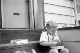
Ashley May's 4th birthday, June 11, 1953
Part of Major Matthews collection
Snapshot shows Ashley May Abbott opening her birthday present from her great-grandfather, Major Matthews.
![Bruce, Wendy & Ashley [Abbott] taken on the back veranda against the dining room windows](/uploads/r/null/f/e/febacfb85ed3884708d932388c656a5f12c517d9e30929dda8ecb0ef00681024/ae413225-6864-4e23-b24f-d3741e2f41fa-A71118_142.jpg)
Bruce, Wendy & Ashley [Abbott] taken on the back veranda against the dining room windows
Part of Major Matthews collection
![McNair Fraser logging camp [at] Hollyburn](/uploads/r/null/6/1/6127900d60495b36275d2030b34833c0def918d3be9decbb28759fee910cb52e/d4084822-050b-4a5a-9c65-a7966aa8799d-A32031_142.jpg)
McNair Fraser logging camp [at] Hollyburn
Part of Major Matthews collection
Photograph shows a 'Walking Dudley' hauling logs
![McNair Fraser logging camp [at] Hollyburn](/uploads/r/null/4/3/438cb9f3ea9ffba41568e3e2b27fcc09e3edc5e1ce64634bd8622bb56e1b6c35/1ae97068-fc03-444d-b48f-f4d8a9a5c325-A32033_142.jpg)
McNair Fraser logging camp [at] Hollyburn
Part of Major Matthews collection
Photograph shows the "Walking Dudley' hauling logs

Part of Major Matthews collection

Part of Major Matthews collection
The map is a draft of MAP 56.01, "Indian villages and landmarks, Burrard Inlet and English Bay, before the whiteman came." It shows the geographic area bounded by the north shore of Burrard Inlet, the Freaser River, Point Atkinson, and the Burrard Inlet Second Narrows. Shown on the map are locations of First Nations and European settlements, streams, coastal features, and inland vegitation. Physical features are labeled using both First Nations and European place names.

Draft map of Indian villages and landmarks, Burrard Inlet and English Bay, before the whiteman came
Part of Major Matthews collection
The map is a draft of map 56.01, "Indian villages and landmarks, Burrard Inlet and English Bay, before the whiteman came." It shows the geographic area bounded by the north shore of Burrard Inlet, the Fraser River, Point Atkinson, and the Burrard Inlet Second Narrows. Shown on the map are coastal sites labeled with First Nations place names.
![[Collapse of the Capilano Creek (River) bridge]](/uploads/r/null/6/e/6e56ae40a9fe4beb643b20db36a23c99034bb5f5a8d8eb18f935c186e10e3669/4fc2c8f4-5dc5-407a-b666-2d1f686edd49-A63120_142.jpg)
[Collapse of the Capilano Creek (River) bridge]
Part of Major Matthews collection

English Bay, Point Grey in forest
Part of Major Matthews collection
Photograph shows a view from West Vancouver across the water
![[Valleen and Helen Thompson]](/uploads/r/null/c/a/ca9c4e30fbe529d8fd365cb5759b52f31a39b6c63befa1d3c9542ef721ac904e/b55d9804-83d5-47f4-9b71-5c9b56a9e7bd-A62106_142.jpg)
Part of Major Matthews collection
Studio portrait
![[View of Marine Drive looking west from 14th Street]](/uploads/r/null/1/d/1ddcd5b670835b959ef9e34ebed4515826f41620f919f648f91ab02ef24e52ec/98f75abf-36f0-4117-8ac3-91c5674158e8-A61057_142.jpg)
[View of Marine Drive looking west from 14th Street]
Part of Major Matthews collection

B.C. Electric Head Office Staff Picnic Seaside Park Aug. 11-23
Part of Major Matthews collection
Group portrait
![[Caretaker's cottage and stable at Larson's Ranch, Larson Bay]](/uploads/r/null/5/6/564b7e92727476d06c920c59321097ac2b08a64c9a3d00d3777d26478cb73696/14f2fb1c-2243-4cdb-b113-f23d21d5c906-A09907_142.jpg)
[Caretaker's cottage and stable at Larson's Ranch, Larson Bay]
Part of Major Matthews collection
![[Exterior of first house at Caulfield]](/uploads/r/null/f/4/f41bfbbab0339cffd2a93f1f3b9486b2d4b89ed1fa383d507e1fd33717bb90a4/76cdc763-c9e3-43c5-b079-78e3e132b4d6-A26850_142.jpg)
[Exterior of first house at Caulfield]
Part of Major Matthews collection
![[Coronation display over the parking lot at Park Royal Shopping Centre]](/uploads/r/null/2/e/2e78669158e409d51bbff524fdcbc90f61e37dc46a9e5dd5952efb90945cfb07/6de3cdf7-cc52-4f73-a008-a7372d4adfb5-A31853_142.jpg)
[Coronation display over the parking lot at Park Royal Shopping Centre]
Part of Major Matthews collection