
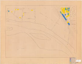
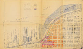
Proposed industrial subdivision - Joyce and Vanness
- COV-S648---: LEG1357.03
- Item
- Jun. 1, 1956
Part of City of Vancouver fonds
70942 results with digital objects Show results with digital objects
Proposed industrial subdivision - Joyce and Vanness
Part of City of Vancouver fonds
![[View of Mount Pleasant]](/uploads/r/null/0/c/9/0c9db5e81df211f273f5e890c4cf2f482734489cf47c53831e2f430410336c9b/259201ec-18df-4a3e-9317-7b6aa211e33b-CVA808-9_142.jpg)
Part of City of Vancouver fonds
![[House at] 743 East Pender Street](/uploads/r/null/c/7/c7cb8ee7375a3f7c85b16d6bcac69252f03f7c76ae6b935d36a1953256db0d03/347d091d-7104-4d2a-813d-8f7daf51862c-A61546_142.jpg)
[House at] 743 East Pender Street
Part of City of Vancouver fonds
![[House at 727] Keefer Street](/uploads/r/null/c/4/c41bd7532c24c871c2ed8be83f67d581b21d06c4e1819f00079cee73d5982dea/4602d0e0-b009-4c67-8272-e4286b496b86-A61552_142.jpg)
Part of City of Vancouver fonds
![[Buildings at] 886-898 Union Street](/uploads/r/null/0/9/0998c98e83ff573660605fb2e05e845a11f9807872f6f8eef620b2160352a8aa/78776bb6-68ae-449c-b26d-449b666e881b-A61555_142.jpg)
[Buildings at] 886-898 Union Street
Part of City of Vancouver fonds
![[Buildings at] 606 Union Street](/uploads/r/null/5/5/556bc3293559172a8a9849d9d55ac756b4c21caeeb58ffa5b2f607753cb9d958/61a17ec4-7c57-489e-8c5c-7c0726a3c713-A61558_142.jpg)
[Buildings at] 606 Union Street
Part of City of Vancouver fonds
![[Buildings at] 606 Union Street](/uploads/r/null/b/0/b057b3e56c0a625078b403bddd58250fc8e9ae22c257d73f648900eaaf78e740/70639922-761f-473b-84b4-065c3025f125-A61559_142.jpg)
[Buildings at] 606 Union Street
Part of City of Vancouver fonds

Project 2 : generalized plan of redevelopment
Part of City of Vancouver fonds
Item is the index map showing the boundaries of the various sub-areas of redevelopment project no. 2. The map shows the boundaries of clearance and redevelopment areas, the proposed street system and the proposed land use for the area from Burrard Inlet in the north to 16th Avenue in the south and from Nanaimo Street in the east to Arbutus Street in the west.

Project 2, part of area "a" : condition of buildings
Part of City of Vancouver fonds
Item is a map showing the condition of buildings (ranging from very good to very poor) within the boundaries of project 2, area "a". The map also shows the boundaries of project 2 clearance, the boundaries of project 1 clearance and the realignment of Raymur Avenue.

Project 2, part of area "a" : existing utilities, water and sewer
Part of City of Vancouver fonds
Item is a map showing the configuration of water and sewer services in project 2 area "a". The map depicts the water pipes (10" and over), the sewers (15" and over), and the direction of sewer flow.

Part of City of Vancouver fonds
Item shows locations and exteriors of buildings in the area bounded by Oak Street, Yukon Street, Broadway, and 16th Avenue.

Age of buildings : Main Street to Clark Drive and Prior Street/Venables Street to Broadway
Part of City of Vancouver fonds
Sheet is annotated to show the boundary of Area 'H' for the Vancouver Redevelopment Study.

Age of buildings : Arbutus Street to Oak Street and Odgen Avenue to Broadway
Part of City of Vancouver fonds

Age of buildings : Slocan Street to Boundary Road and 5th Avenue to 22nd Avenue
Part of City of Vancouver fonds
Part of City of Vancouver fonds

Age of buildings : Crown Street to Blenheim Street and 41st Avenue to 55th Avenue
Part of City of Vancouver fonds
Age of buildings : Blanca Street to Discovery Street and 10th Avenue to 16th Avenue
Part of City of Vancouver fonds
Age of buildings : Clark Drive to Slocan Street and Hastings Street to 6th Avenue
Part of City of Vancouver fonds

Part of City of Vancouver fonds

Age of buildings : Clark Drive to Slocan Street and Powell Street/Wall Street to Hastings Street
Part of City of Vancouver fonds

Age of buildings : Knight Street to Slocan Street/Wales Street and 22nd Avenue to 37th Avenue
Part of City of Vancouver fonds
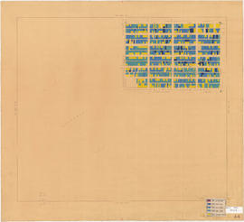
Industry : parking : on street
Part of City of Vancouver fonds
Map is Plan no. 4105A Sheet 7 of 11 of the City of Vancouver, showing streets, blocks, hospitals, golf courses, First Nations reserves, parks, schools, city yards and cemetery. Map is hand coloured to show full parking, half parking, no parking and no parking allowed. Map is labelled "1964 April 4105 A-7 Industrial Study 1964." Base map is amended to May 1961.
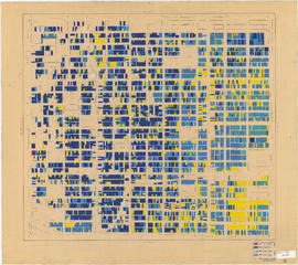
Part of City of Vancouver fonds
Map is Plan no. 4105A Sheet 8 of 11 of the City of Vancouver, showing streets, blocks, hospitals, golf courses, First Nations reserves, parks, schools, city yards and cemetery. Map is hand coloured to show designated routes, designated areas for different sizes of commercial vehicles, the central district and areas zoned for industry. Map is labelled "1963 4105 A-8 Industrial Study 1964." Base map is amended to May 1961.
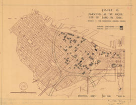
Figure 10 : parking as the major use of land in 1954
Part of City of Vancouver fonds
Map is a plan of downtown Vancouver showing parking structures and parking lots in the area between Jervis Street and Main Street and Burrard Inlet and Nelson Street. The source of the map is indicated as 'The Downtown Parking Report'. Note written in the bottom right corner of the map reads "B 1960 Jan., Traffic Plans, small folder."
![City of Vancouver [Existing super-markets : date of erection, size and location]](/uploads/r/null/c/9/9/c994b91e283c9d37d539b5381734a5b8dd287c7cc8da9ba54b10a82d884e42b2/99137e02-fef1-48fe-8563-9abd1c74c42f-LEG1202_142.jpg)
City of Vancouver [Existing super-markets : date of erection, size and location]
Part of City of Vancouver fonds
Item is a map annotated to show major arterial roads and location, size, and building date of supermarkets. Base map is numbered C.B.M. 1500 and shows roads, golf courses, and parks.
![Age of bldgs. [buildings] : 1000-1300 Granville Street](/uploads/r/null/f/6/1/f616b7dd30e14793c36bdae78e7ac9d8a918586b9b1b461a4888b74a53c4c228/3f061937-ef69-4bc5-81ce-d99a0ad6e7ce-LEG1202_142.jpg)
Age of bldgs. [buildings] : 1000-1300 Granville Street
Part of City of Vancouver fonds
Item is a map annotated to show age of buildings by fifteen-year increments from 1900 to 1960, and from 1961 on. Base map shows streets, building outlines, and topographical contour lines.
Land use : Semlin Drive to Nanaimo Street and Burrard Inlet to Triumph Street
Part of City of Vancouver fonds
Item is a map annotated to show residential, commercial and industrial land use. Base map shows streets, legal addresses, and waterfront businesses in the area from Clark Drive to Slocan Street and Burrard Inlet to Powell Street/Triumph Street.

Group of workers walking, carrying metal lunchboxes
Part of City of Vancouver fonds

Project 2, part of area "a" : existing gas, electricity and telephone
Part of City of Vancouver fonds
Item is a map showing the gas lines, overhead and underground electricity lines, overhead and underground telephone lines, and fire alarms underground in project 2 area "a".

Project 2, area "h" and part of "b" : condition of buildings
Part of City of Vancouver fonds
Item is a map showing the condition of buildings (ranging from very good to very poor), the boundaries of redevelopment for areas "b" and "h" and the boundaries of project clearance for areas 8 and 9 for redevelopment proct 2.

Project 2, area a-2 : condition of buildings
Part of City of Vancouver fonds
Item is a map showing condition of buildings (ranging from very good to very poor) and sites without buildings in use for storage or parking in the area from Railway Street in the north to Atlantic Street in the south and from Clark Drive in the east to Main Street in the west.

Project 2: identification plan
Part of City of Vancouver fonds
Item is a map showing city owned property, adjacent lots in same ownership, non-adjacent lots in same ownership, property to be acquired, streets and lanes to be acquired, the boundaries of project 2 clearance, the boundaries of project 1 clearance and the realignment of Raymur Avenue in the area from Railway Street in the north to Atlantic Street in the south and from Clark Drive in the east to Main Steet in the west.

Project 2, area a-2 : proposed property acquisitions project 2
Part of City of Vancouver fonds
Item is a map showing boundaries of project in area a, property to be acquired, proposed street widening and city owned property included. Annotations show boundaries of project areas, property too be acquired, proposed street widening and properties already owned by the City. Map has been noted as Preliminary.

Project 2, part of area "a" : aerial photograph
Part of City of Vancouver fonds
Item is a map in the form of an aerial photograph, which depicting the part of the city covered by the project: from Railway Street in the north to Prior Street in the south and from Clark Drive in the east to Main Street in the west.
Attached label indicates that the map was approved by Council Sept. 17, 1963.

Project 2, part of area "a" : existing utilities, water and sewer
Part of City of Vancouver fonds
Item is a map showing the water pipes (10" and over), the sewers (15" and over), the direction of sewer flow, the boundaries of project 2 clearance, the boundaries of project 1 clearance and the realignment of Raymur Avenue in the area from Burrard Inlet in the north to Atlantic Street in the south and from Clark Drive in the east to Main Street in the west.
Attached label indicates that the map was approved by Council Sept. 17, 1963.

Project 2, part of area "a" : existing utilities, gas, electricity and telephone
Part of City of Vancouver fonds
Item is a map showing the gas lines, the overhead and underground electricity lines, the overhead and underground telephone lines, the fire alarms underground, the boundaries of project 2 clearance, the boundaries of project 1 clearance and the realignment of Raymur Avenue in the area from Railway Street in the north to Atlantic Street in the south and from Clark Drive in the east to Main Street in the west.
Attached label indicates that the map was approved by Council Sept. 17, 1963.

Project 2, part of area "a" : utility diversions and rearrangements
Part of City of Vancouver fonds
Item is a map showing boundaries of clearance areas for project 2 (areas 5 (part), 6 and 7) and project 1 (area 3). Maps also show sewers to remain, sewers to be abandoned, water lines to remain, water lines to be abandoned, gas lines to remain, gas lines to be abandoned, power lines existing underground, proposed diversions of power lines, power lines existing overhead, proposed overhead power lines and long distance telephone lines existing underground. Larger map shows area from Hastings Street in the north to Union Street in the south and from Heatley Avenue in the east to Gore Avenue in the west. Smaller map shows area from Powell Street in the north to Hastings Street in the south and from Clark Drive in the east to Glen Drive in the west. Item also shows estimates of costs for utility diversions and rearrangements for areas 5, 6 and 7.
Attached label indicates that the map was approved by Council Sept. 17, 1963.

Project 2, part of area "a" : identification plan
Part of City of Vancouver fonds
Item is a map showing city owned property, adjacent lots in same ownership, non-adjacent lots in same ownership, property to be acquired, streets and lanes to be acquired, the boundaries for project 2 clearance, the boundaries for project 1 clearance and the realignment of Raymur Ave for the area from Railway Street in the north to Atlantic Street in the south and from Clarke Drive in the east to Main Street in the west.
Attached label indicates that the map was approved by Council Sept. 17, 1963.

Redevelopment Project No. 2 Plan No. 1
Part of City of Vancouver fonds
Item is an index plan showing the various area sub-projects for redevelopment project no. 2, and designates comprehensive vs. limited re-development areas. Area A-6 is highlighted in red.
City of Vancouver, east approach route. Alignment alternatives investigated
Part of City of Vancouver fonds
Item is a map which has been created out of a sepia diazotype copy of an aerial photograph of downtown Vancouver. The map has been annotated to show thirteen different schemes for freeway routes to connect the Trans-Canada Highway with downtown Vancouver from the east. The map shows the consultants' preferred route and other alignments investigated.
Phillips, Barratt, Hillier, Jones and Partners, Engineers (Vancouver, B.C.)

Fourteenth Annual fireman's ball, 1912, invitation
Part of City of Vancouver fonds
Item is a copy negative of a photograph of an invitation toVancouver Fireman's Benefit Association's fourteenth annual ball & supper, at Dominion hall, Pender Street, Feb. 8th, 1912, Vancouver (B.C.).

Fourteenth Annual fireman's ball, 1912, dance program, front page
Part of City of Vancouver fonds
Item is a copy negative of a photograph of a page of the dance program from the Vancouver Fireman's Benefit Association's 14th annual ball & supper, at Dominion Hall, Pender Street, Feb. 8th, 1912, Vancouver (B.C.). The cover shows an image of an Amoskeag steam engine of 1908.
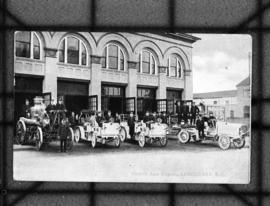
Firehall auto brigade, Vancouver, B.C.
Part of City of Vancouver fonds
Item is a copy negative of a photograph of the fire hall auto brigade, Vancouver (B.C.), showing manned equipment, at #1 station on the southwest corner of Gore ave. on Cordova. Picured are a 1908 Amaskeag self-propelled steam pump, chemical and hose wagons, and an 85’ aerial ladder. Deputy Chief Chas. Thompson is identified in front of the Amaskeag steam pump (left).
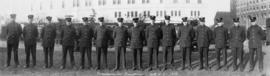
Vancouver Fire Department - Hall No. 2
Part of City of Vancouver fonds
Panoramic view showing group portrait on the grounds of the courthouse with a fire truck in the background

Vancouver Fire Department No. 18
Part of City of Vancouver fonds
Panoramic group portrait in front of Fire Hall No. 18 showing a fire truck in the background

Firefighters and equipment in action at G.H. Cottrell Warehouse, 139 Water Street
Part of City of Vancouver fonds

Firefighting equipment at scene of Imperial Oil Company fire, Smithe Street
Part of City of Vancouver fonds

Fire Department Band performing by pool in front of bleachers
Part of City of Vancouver fonds
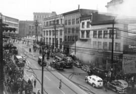
Fire engines and spectators at three alarm fire at Park Hotel
Part of City of Vancouver fonds
Item is a photograph of firefighters attending a fire at the Park Hotel, 177 West Pender Street. Writing on the back of the item indicates the fire was attended at 1:05 pm and struck out at 5:24 pm, "39 overcome with smoke and 18 were hospitalized."

Group portrait of fire chiefs in civilian dress with reporter Simma Holt
Part of City of Vancouver fonds
Item is a photograph showing (L-R): seated - E.L. Erratt, J.H. De Graves, Simma Holt, C.W. Thompson, A.McDiarmid, A.R. Murray ; standing - Malcolm MacDonald, William Plumsteel, Angus Lougheed, Walter Fox, Harvey Bowering.