![[Boat in Burrard Inlet, near Brockton Point]](/uploads/r/null/0/c/0c2fa95b7dc1fa230d6e1536914f2653429ab4c9d5964b9720c697e3971cdba6/07ce4d85-4bef-42ff-996f-f6a284719e8d-A04014_142.jpg)
[Boat in Burrard Inlet, near Brockton Point]
- AM54-S4-: SGN 109
- Item
- [189-?]
Part of Major Matthews collection
J.S. Matthews' notes with print or negative in Archives.
[Boat in Burrard Inlet, near Brockton Point]
Part of Major Matthews collection
J.S. Matthews' notes with print or negative in Archives.
![[Composite view of ships and Stanley Park sites]](/uploads/r/null/3/c/3c46b96242786e4b1aad8df2b667da89143a46e55dc4a60c9541d68888ae6ac9/d6361a9b-8768-494b-911e-6f055c94677c-A03966_142.jpg)
[Composite view of ships and Stanley Park sites]
Part of Major Matthews collection
Photograph consists of a composite of four photographs showing: large tree in Stanley Park, bridge in Stanley Park, the S.S. "Beaver" on shore (Bo P124), and the "Empress of India" at Vancouver dock (Bo P 6.4).
![[Portion of Hotel Vancouver and C.P.R. Park - Georgia and Granville Streets]](/uploads/r/null/0/8/0826d810885e2f074ec627936c089697466a22e01f5562dc2a51e13a42155c70/1b22e9ae-af84-4c04-9b76-e77b654b08f7-A26278_142.jpg)
[Portion of Hotel Vancouver and C.P.R. Park - Georgia and Granville Streets]
Part of Major Matthews collection
![[Victory Square from Hamilton and Pender Streets]](/uploads/r/null/6/2/62b2cc793a1eeb813d57679932ab341d111fd927f214aa829d1e166ad0e48d6f/fda4a7e6-5f02-4bb2-9b79-ec6ffa0c6796-A09379_142.jpg)
[Victory Square from Hamilton and Pender Streets]
Part of Major Matthews collection
![[View of Canadian National Railway Station and Thornton Park on Main Street]](/uploads/r/null/c/9/c961e1f1320ac57335b7e20fae0721892e8c205c534eb19f36d0e03d03c64ce7/1f1bb4be-daf4-4846-bfe3-936e4fb65113-A25331_142.jpg)
[View of Canadian National Railway Station and Thornton Park on Main Street]
Part of Major Matthews collection
Photograph shows the C.N.R. Freight, National Canners Ltd. and the Massey-Harris buildings.

Part of Major Matthews collection
J.S. Matthews' notes with print or negative in Archives.
![[Tea being spread out to dry in C.P.R. park at Granville and Georgia Streets]](/uploads/r/null/e/a/ea5109d580850cc7de7b0d1c95ecdc16c53da1cd22377840fcebf5ec89f96293/9b00d96a-5fb7-4947-aef3-46ed92d5d852-A04882_142.jpg)
[Tea being spread out to dry in C.P.R. park at Granville and Georgia Streets]
Part of Major Matthews collection
Photograph shows a customs agent sitting on a box of tea, watching Asian workers empty tea out of boxes and spread it out to dry with rakes.
![[The C.P.R. Park at the corner of Georgia Street and Granville Street]](/uploads/r/null/d/7/d795a97face73a83c2531cf51175d92c0447616a644e41a6e8f91ce1df9ac547/e543c340-8fdb-4fc5-9992-a6dca03297dd-A36999_142.jpg)
[The C.P.R. Park at the corner of Georgia Street and Granville Street]
Part of Major Matthews collection
![[View of Pioneer Place, corner of Carrall Street and Hastings]](/uploads/r/null/7/1/7129a13ad6f67f2a3d990fd0cf849e8e04dd0e36e7d23c461bb804e103c93b92/c193dad4-aa2f-463e-b5a6-aa4e2ee02d74-A10285_142.jpg)
[View of Pioneer Place, corner of Carrall Street and Hastings]
Part of Major Matthews collection

Selected park programs for additional park sites 1959-1976
Part of City of Vancouver Archives technical and cartographic drawing collection
Item is a map showing park programs for 1959-1976. Map was most likely created by the parks department and includes a legend depicting the following information: program A (7,200,000), program B (18,000,000), program C (28,800,000), potential major park sites from which additional acreage is to be selected for each program and existing park sites. The map shows locations selected for alternative programs and locations omitted from alternative programs. Map shows street names and extends from Boundary Road to Stanley Park to University Endowment Lands to Lulu Island.

Sheet 6 : Knight Street to Slocan Street and Eighteenth Avenue to Twenty-ninth Avenue
Part of City of Vancouver Archives technical and cartographic drawing collection
Item is a section showing the area from Knight Street to Slocan Street and Eighteenth Avenue to Twenty-ninth Avenue. Includes streets and roads, blocks, lots, legal descriptions, railways, parks and schools. Some annotations have been made in pencil.
Vancouver (B.C.). Office of the City Engineer

Sheet 8 : McLean Drive to Slocan Street and William Street to Seventh Avenue
Part of City of Vancouver Archives technical and cartographic drawing collection
Item is a section showing the area from McLean Drive to Slocan Street and William Street to Seventh Avenue. Includes streets and roads, blocks, lots, legal descriptions, railways, parks, schools and some businesses.
Vancouver (B.C.). Office of the City Engineer

Sheet 12 : Ontario Street to Clark Drive and Keefer Street to Second Avenue
Part of City of Vancouver Archives technical and cartographic drawing collection
Item is a section showing the area from Ontario Street to Clark Drive and Keefer Street to Second Avenue. Includes streets, roads, blocks, lots, legal descriptions, railways, parks and schools. Includes Terminal Avenue and land used by the Great Northern Railway and the Canadian National Railway.
Vancouver (B.C.). Office of the City Engineer

Sheet 17 : Trutch Street to Maple Street and Fourth Avenue to Sixteenth Avenue
Part of City of Vancouver Archives technical and cartographic drawing collection
Item is a section showing Trutch Street to Maple Street and Fourth Avenue to Sixteenth Avenue. Includes streets, roads, blocks, lots, legal descriptions, parks and schools.
Vancouver (B.C.). Office of the City Engineer

Sheet 12 : Prince Edward Street to Bruce Street and Forty-seventh Avenue to Fifty-eighth Avenue
Part of City of Vancouver Archives technical and cartographic drawing collection
Item is a section showing the area from Prince Edward Street to Bruce Street and Forty-seventh Avenue to Fifty-eighth Avenue. Includes streets, roads, blocks, lots, legal descriptions, parks and schools.
Vancouver (B.C.). Office of the City Engineer

Sheet 23 : Stanley Park to Granville Street and Robson Street to False Creek
Part of City of Vancouver Archives technical and cartographic drawing collection
Item is a section showing the area from Stanley Park to Granville Street and Robson Street to False Creek. Includes streets, roads and railways; blocks, lots and legal descriptions; as well as parks, schools, hospitals and churches. Shows the Burrard Bridge and C.P.R. property.
Vancouver (B.C.). Office of the City Engineer

Sheet M : Granville Street to Kersland Drive and Twenty-seventh Avenue to Thirty-eighth Avenue
Part of City of Vancouver Archives technical and cartographic drawing collection
Item is a section showing the area from Granville Street to Kersland Drive and Twenty-seventh Avenue to Thirty-eighth Avenue. Includes streets and roads; blocks, lots and legal descriptions; and golf courses, parks and government buildings.
Vancouver (B.C.). Office of the City Engineer

Sheet N : Musqueam Reserve to Wallace Street and Thirty-eighth Avenue to Forty-ninth Avenue
Part of City of Vancouver Archives technical and cartographic drawing collection
Item is a section showing the area from the Musqueam Reserve to Wallace Street and Thirty-eighth Avenue to Forty-ninth Avenue. Includes streets, roads and sewers; blocks, lots and legal descriptions; and parks and schools.
Vancouver (B.C.). Office of the City Engineer

Sheet T : Marine Crescent to Granville Street and Forty-ninth Avenue to Sixty-first Avenue
Part of City of Vancouver Archives technical and cartographic drawing collection
Item is a section showing the area from Marine Crescent to Granville Street and Forty-ninth Avenue to Sixty-first Avenue. Includes streets and roads; blocks, lots and legal descriptions; and parks and golf courses.
Vancouver (B.C.). Office of the City Engineer

Sheet 4 : Prince Edward Street to Bruce Street and King Edward Avenue to Thirty-sixth Avenue
Part of City of Vancouver Archives technical and cartographic drawing collection
Item is a section showing the area from Prince Edward Street to Bruce Street and King Edward Avenue to Thirty-sixth Avenue. Map shows streets, roads, blocks, lots and legal descriptions, and the locations of parks, schools and Mountainview Cemetery.
Vancouver (B.C.). Office of the City Engineer

Sheet 5 : Slocan Street to Boundary Road and Seventeenth Avenue to Twenty-ninth Avenue
Part of City of Vancouver Archives technical and cartographic drawing collection
Item is a section showing the area from Slocan Street to Boundary Road and Seventeenth Avenue to Twenty-ninth Avenue. Includes streets and roads, blocks, lots, legal descriptions, railways, parks, schools and the Vancouver Preventorium (for tuberculosis patients). Some annotations have been made in pencil.
Vancouver (B.C.). Office of the City Engineer

Sheet 8 : McLean Drive to Slocan Street and William Street to Seventh Avenue
Part of City of Vancouver Archives technical and cartographic drawing collection
Item is a section showing the area from McLean Drive to Slocan Street and William Street to Seventh Avenue. Includes streets and roads, blocks, lots, legal descriptions, railways, parks, schools and some businesses.
Vancouver (B.C.). Office of the City Engineer

Sheet 10 : Clark Drive to Slocan Street and waterfront to Triumph Street
Part of City of Vancouver Archives technical and cartographic drawing collection
Item is a section showing the area from Clark Drive to Slocan Street and aterfront to Triumph Street. Includes streets and roads, blocks, lots, legal descriptions, railways, parks, boys' detention home and businesses along the waterfront. The Town of Hastings is indicated on the map.
Vancouver (B.C.). Office of the City Engineer

Sheet 3 : Slocan Street to Boundary Road and Seventh Avenue to Charles Street
Part of City of Vancouver Archives technical and cartographic drawing collection
Item is a section showing the area from Slocan Street to Boundary Road and Seventh Avenue to Charles Street. Includes streets and roads, blocks, lots, legal descriptions, parks and schools.
Vancouver (B.C.). Office of the City Engineer

Sheet 16 : Maple Street to Oak Street and False Creek to Sixteenth Avenue
Part of City of Vancouver Archives technical and cartographic drawing collection
Item is a section showing Maple Street to Oak Street and False Creek to Sixteenth Avenue. Includes streets and roads, blocks, lots, legal descriptions, railways, schools and parks. Indicates crown land leased to the C.P.R. and other bodies.
Vancouver (B.C.). Office of the City Engineer

Sheet 18 : Trutch Street to Maple Street and English Bay to Third Avenue
Part of City of Vancouver Archives technical and cartographic drawing collection
Item is a section showing Trutch Street to Maple Street and English Bay to Third Avenue. Includes streets, roads, blocks, lots, legal descriptions, parks and crown grants.

Sheet 19 : Maple Street to Richards Street and Drake Street to Third Avenue
Part of City of Vancouver Archives technical and cartographic drawing collection
Item is a section showing Maple Street to Richards Street and Drake Street to Third Avenue. Includes streets, roads, blocks, lots, legal descriptions, parks, schools, the Burrard and Granville Street Bridges, C.P.R. right-of-ways, the Squamish Band reserve, C.P.R. leases and property, and government reserve. Map includes Granville Island.

Sheet 21 : Burrard Street to False Creek and waterfront to Robson Street
Part of City of Vancouver Archives technical and cartographic drawing collection
Item is a section showing Burrard Street to False Creek and waterfront to Robson Street. Includes streets and roads; blocks, lots and legal descriptions; the locations of hotels, court house, businesses, parks, and schools; crown leases; C.P.R. land and the company's Piers B and C, yards, sheds and depot; the B.C. Electric Railway Carrall Street Yard; and the Union Steamship Company.

Sheet A : University Endowment Lands to Discovery Street and waterfront to Fifth Avenue
Part of City of Vancouver Archives technical and cartographic drawing collection
Item is a section showing the area from the University Endowment Lands to Discovery Street and waterfront to Fifth Avenue. Includes streets, roads and sewers; blocks, lots and legal descriptions; and parks and schools. Annotations in pencil.
Vancouver (B.C.). Office of the City Engineer

Sheet E : University Endowment Lands to Wallace Street and Sixteenth Avenue to Twenty-seventh Avenue
Part of City of Vancouver Archives technical and cartographic drawing collection
Item is a section showing the area from the University Endowment Lands to Wallace Street and Sixteenth Avenue to Twenty-seventh Avenue. Includes streets and roads; blocks, lots and legal descriptions; and parks and schools.
Vancouver (B.C.). Office of the City Engineer

Sheet H : Alexandra Street to Cambie Street and Fifteenth Avenue to Twenty-seventh Avenue
Part of City of Vancouver Archives technical and cartographic drawing collection
Item is a section showing the area from Alexandra Street to Cambie Street and Fifteenth Avenue to Twenty-seventh Avenue.Includes streets and roads; blocks, lots and legal descriptions; as well as parks, schools, hospitals and golf courses.
Vancouver (B.C.). Office of the City Engineer

Sheet S.V. 1 : Cambie Street to Carolina Street and Sixteenth Avenue to Twenty-eighth Avenue
Part of City of Vancouver Archives technical and cartographic drawing collection
Item is a section showing the area from Cambie Street to Carolina Street and Sixteenth Avenue to Twenty-eighth Avenue. Includes streets, roads, blocks, lots, legal descriptions, parks, nurseries and schools.
Vancouver (B.C.). Office of the City Engineer

Sheet S.V. 3 : Cambie Street to Prince Edward Street and Thirty-ninth Avenue to Fiftieth Avenue
Part of City of Vancouver Archives technical and cartographic drawing collection
Item is a section showing the area from Cambie Street to Prince Edward Street and Thirty-ninth Avenue to Fiftieth Avenue. Map shows streets, roads, blocks, lots and legal descriptions, and the locations of parks, schools, golf courses and Mountainview Cemetery.
Vancouver (B.C.). Office of the City Engineer

Sheet S.V. 13 : Borden Street to Jellicoe Street and Sixtieth Avenue to Fraser River
Part of City of Vancouver Archives technical and cartographic drawing collection
Item is a section showing the area from Borden Street to Jellicoe Street and Sixtieth Avenue to Fraser River. Includes streets, roads, railway lines, blocks, lots, legal descriptions, parks, golf courses and schools. Annotations in pencil.
Vancouver (B.C.). Office of the City Engineer

Sheet 33 : Clark Drive to Nanaimo Street and Thirteenth Avenue to Second Avenue
Part of City of Vancouver Archives technical and cartographic drawing collection
Item is a section showing the area from Clark Drive to Nanaimo Street and Thirteenth Avenue to Second Avenue. Includes streets, blocks, lots and legal descriptions, and the locations of parks, schools and railways.
Vancouver (B.C.). Engineering Services

Sheet 5 : Stanley Park to Nicola Street and English Bay Beach to Robson Street
Part of City of Vancouver Archives technical and cartographic drawing collection
Item is a section showing the area from Stanley Park to Nicola Street and English Bay Beach to Robson Street. Includes streets, blocks, lots and legal descriptions, and the locations of parks, beaches, schools and golf courses.
Vancouver (B.C.). Engineering Services

Sheet 11 : Wall Street to Rupert Street and McGill Street to Burrard Inlet
Part of City of Vancouver Archives technical and cartographic drawing collection
Item is a section showing the area from Wall Street to Rupert Street and McGill Street to Burrard Inlet. Includes streets, blocks, lots and legal descriptions, and the locations of parks, schools, and railways.
Vancouver (B.C.). Engineering Services

Sheet 13 : Rupert Street to Boundary Road and Eton Street to Burrard Inlet
Part of City of Vancouver Archives technical and cartographic drawing collection
Item is a section showing the area from Rupert Street to Boundary Road and Eton Street to Burrard Inlet. Includes streets, blocks, lots and legal descriptions and schools.
Vancouver (B.C.). Engineering Services

Sheet 17 : Nanaimo Street to Rupert Street and Charles Street to Pender Street
Part of City of Vancouver Archives technical and cartographic drawing collection
Item is a section showing the area from Nanaimo Street to Rupert Street and Charles Street to Pender Street. Includes streets, blocks, lots and legal descriptions. Includes streets, blocks, lots and legal descriptions, and the locations of parks and schools.
Vancouver (B.C.). Engineering Services
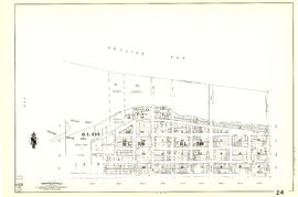
Sheet 24 : Jericho Beach to Balaclava Street and Fourth Avenue to Cameron Avenue
Part of City of Vancouver Archives technical and cartographic drawing collection
Item is a section showing the area from Jericho Beach to Balaclava Street and Fourth Avenue to Cameron Avenue. Includes streets, blocks, lots and legal descriptions, and the locations of parks and beaches.
Vancouver (B.C.). Engineering Services

Part of City of Vancouver Archives technical and cartographic drawing collection
Item is a section showing the area from Rupert Street to Boundary Road and Wellington Avenue to Twenty-second Avenue. Includes streets, blocks, lots and legal descriptions, and the locations of parks and schools. Also included are streets and blocks in the area from Boundary Road to Carleton Avenue in Burnaby.
Vancouver (B.C.). Engineering Services

Sheet 39 : Kingsway and Nanaimo Street to Rupert Street and Ward Street to Twenty-second Avenue
Part of City of Vancouver Archives technical and cartographic drawing collection
Item is a section showing the area from Kingsway and Nanaimo Street to Rupert Street and Ward Street to Twenty-second Avenue. Includes streets, blocks, lots and legal descriptions, and the locations of parks, schools and railways.
Vancouver (B.C.). Engineering Services
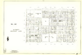
Sheet 47 : Camosun Street to Blenheim Street and Thirty-third Avenue to King Edward Avenue
Part of City of Vancouver Archives technical and cartographic drawing collection
Item is a section showing the area from Camosun Street to Blenheim Street and Thirty-third Avenue to King Edward Avenue. Includes streets, blocks, lots and legal descriptions, and the locations of parks and schools.
Vancouver (B.C.). Engineering Services

Sheet 50 : Oak Street to Ontario Street and Thirty-seventh Avenue to Twenty-eighth Avenue
Part of City of Vancouver Archives technical and cartographic drawing collection
Item is a section showing the area from Oak Street to Ontario Street and Thirty-seventh Avenue to Twenty-eighth Avenue. Includes streets, blocks, lots and legal descriptions, and the locations of parks, schools, hospitals, reservoirs, stadiums and RCMP barracks.
Vancouver (B.C.). Engineering Services

Sheet 51 : Ontario Street to Inverness Street and Thirty-seventh Avenue to Twenty-eighth Avenue
Part of City of Vancouver Archives technical and cartographic drawing collection
Item is a section showing the area from Ontario Street to Inverness Street and Thirty-seventh Avenue to Twenty-eighth Avenue. Includes streets, blocks, lots and legal descriptions, and the locations of parks, schools and Mountainview Cemetery.
Vancouver (B.C.). Engineering Services

Sheet 53 : Inverness Street to Nanaimo Street and Forty-first Avenue to Thirty-second Avenue
Part of City of Vancouver Archives technical and cartographic drawing collection
Item is a section showing the area from Inverness Street to Nanaimo Street and Forty-first Avenue to Thirty-second Avenue. Includes streets, blocks, lots and legal descriptions, and the location of parks.
Vancouver (B.C.). Engineering Services

Part of City of Vancouver Archives technical and cartographic drawing collection
Item is a section showing the area from Nanaimo Street to Joyce Street, Cecil Street and McHardy Street and Forty-first Avenue to Ward Street and Vanness Avenue. Includes streets, blocks, lots and legal descriptions, and the locations of parks and schools.
Vancouver (B.C.). Engineering Services
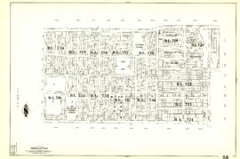
Sheet 58 : Inverness Street to Nanaimo Street and Forty-ninth Avenue to Forty-first Avenue
Part of City of Vancouver Archives technical and cartographic drawing collection
Item is a section showing the area from Inverness Street to Nanaimo Street and Forty-ninth Avenue to Forty-first Avenue. Includes streets, blocks, lots and legal descriptions, and the locations of parks and schools.
Vancouver (B.C.). Engineering Services

Part of City of Vancouver Archives technical and cartographic drawing collection
Item is a section showing the area from Musqueam Indian Reserve to Musqueam Park and North Arm, Fraser River to Southwest Marine Drive. Includes streets, blocks, lots and legal descriptions, and parks.
Vancouver (B.C.). Engineering Services

Sheet 73 : Quebec Street to Inverness Street and Fifty-seventh Avenue to Forty-seventh Avenue
Part of City of Vancouver Archives technical and cartographic drawing collection
Item is a section showing the area from Quebec Street to Inverness Street and Fifty-seventh Avenue to Forty-seventh Avenue. Includes streets, blocks, lots and legal descriptions, and the locations of schools and parks.
Vancouver (B.C.). Engineering Services