![[Collapse of the Capilano Creek (River) bridge]](/uploads/r/null/0/6/06f9274d0513c230cd58241c8f3e62b9cea580597303e4a4ae20a757b0271e20/bcecd925-cfd2-4704-87cf-197c08f6b4b8-A63121_142.jpg)
[Collapse of the Capilano Creek (River) bridge]
- AM54-S4-2-: CVA 371-2705
- Item
- 1917
Part of Major Matthews collection
447 results with digital objects Show results with digital objects
[Collapse of the Capilano Creek (River) bridge]
Part of Major Matthews collection
Mrs. Victor McLean residence : [189 31st Street?] West Vancouver
Part of C.B.K. Van Norman fonds
File consists of the following types of architectural drawings: elevations, floor plans, additions and alterations and structural specifications.
Part of C.B.K. Van Norman fonds
File consists of the following types of architectural drawings: rendering of exterior of shop and floor plan.
Part of C.B.K. Van Norman fonds
File consists of the following types of architectural drawings: rendering of exterior of shop and floor plan.
Part of C.B.K. Van Norman fonds
Proposed residence for Robin Bell-Irving : [1900 Block 30th Street?], West Vancouver
Part of C.B.K. Van Norman fonds
File consists of the following types of architectural drawings: elevations, floor plans and structural specifications.
F.H.H. Parkes residence : [2221 Inglewood Avenue?], West Vancouver
Part of C.B.K. Van Norman fonds
File consists of the following types of architectural drawings: cross section, elevation, floor plan and structural specifications.
J.B. Hoffar residence : British Pacific properties, [881 Taylor Way?] West Vancouver
Part of C.B.K. Van Norman fonds
File consists of the following types of architectural drawings: cross section, elevation, floor plan and structural specifications.
Ken Black residence : Lot 3 Blk 4 Capilano Estates [470 Eastcot Road?], West Vancouver
Part of C.B.K. Van Norman fonds
File consists of the following types of architectural drawings: elevations, floor plans, details and plot plan.
Subdivision and land use (West Vancouver, B.C.)
Slopes : North Shore (West Vancouver, B.C.)
Plan of the subdivision of the north east portion of district lot 1242
![[View from the Lions Gate Bridge of the mouth and delta of the Capilano River]](/uploads/r/null/3/6/36d7a3cda899110ea242541303521e6934274b2876797c95611f8709c01e0dc0/4a8ddffe-948b-48b5-9223-b8555f122e9f-A76099_142.jpg)
[View from the Lions Gate Bridge of the mouth and delta of the Capilano River]
Part of James Crookall fonds
![[View of a sailboat in the choppy waters of Burrard Inlet near the delta of the Capilano River]](/uploads/r/null/9/6/9673c050d4c95de7e6aa9d1e1951acf0e8be226d2bcf8f5628a5edcad0b88390/0a8ea4e5-2c9b-4d27-91d6-c2eb7f8c3d30-A75990_142.jpg)
[View of a sailboat in the choppy waters of Burrard Inlet near the delta of the Capilano River]
Part of James Crookall fonds
![[View of] Great Northern Cannery [from Marine Drive]](/uploads/r/null/d/b/db609d6daff2c0c92d795bec6133f0a2ca6a1afd6f8b1d044d7da52d411072fa/da3c5096-acc2-43b1-9346-c9f2bd8c7ce4-A76303_142.jpg)
[View of] Great Northern Cannery [from Marine Drive]
Part of James Crookall fonds

Plan of the town of Newcastle, English Bay
Part of City of Vancouver Archives technical and cartographic drawing collection
Item is a map showing lot numbers and street names for the proposed town of Newcastle on the north shore of English Bay in what is now West Vancouver. An index map shows the location of Newcastle in relation to Vancouver and English Bay.

Plan of part of West Vancouver District
Part of City of Vancouver Archives technical and cartographic drawing collection
Item is a map of part of West Vancouver District that covers Altamont Station, Marine Drive, 9th Street and Queens Street. Map shows district lot, block, and some lot numbers.

Part of City of Vancouver Archives technical and cartographic drawing collection
Item is a map compiled and drawn by J.S. Matthews, City Archivist showing historic place names of Vancouver and the North Shore and listing some historic Burnaby names. A note in the bottom left hand corner reads: "Memorada. The precise location of "Albert City" is unknown, Narveaz was first; 150 years passed before his name was given to a landmark. His vessel's name "Santa Saturnina" has never been applied to anything at all."

Map of West Vancouver and vicinity
Part of City of Vancouver Archives technical and cartographic drawing collection
Part contains a map of West Vancouver, North Vancouver, and the northern parts of Vancouver and Burnaby. Map shows district lot and block numbers, streets, and distances from City Hall.
Part of City of Vancouver Archives technical and cartographic drawing collection
Item is a map showing land subdivisions for West Vancouver, streets, and railway routes.
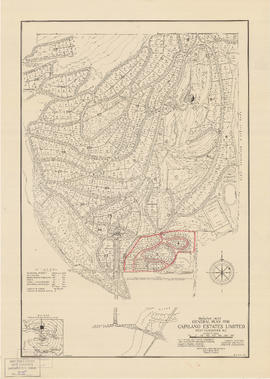
General plan for Capilano Estates Limited
Part of City of Vancouver Archives technical and cartographic drawing collection
Item is a map showing the layout of the proposed Capilano Estates development, including a golf course, a polo field, riding stables, housing lots, and park land. Annotations are pencil outlines of blocks in the southern end of the development.
Vancouver Harbour [sectional map]
Part of City of Vancouver Archives technical and cartographic drawing collection
File contains 42 maps showing soundings, harbour headlines, high water marks, shore lines, shoals, submarine cable, rail lines and trails in the Vancouver area. Maps also show names of businesses and other structures.

Index plan of provincial government lands to be sold at auction at Vancouver B.C. November 20, 1906
Part of City of Vancouver Archives technical and cartographic drawing collection
Item is a map showing lots owned by the provincial government to be sold at auction. Lots are located in North Vancouver, Vancouver, South Vancouver, Hastings Townsite and Burnaby.
The District of West Vancouver [left half]
The District of West Vancouver [right half]
![[Bowler in action]](/uploads/r/null/3/b/3b80b07257eec44ebc60b8db2715c11e9a07d311c8cc6e9e41bfdb79e085e016/00ecdb6c-f2dc-4c42-b3cc-670687bb29bc-A12012_142.jpg)
![[Bowler in Action]](/uploads/r/null/3/9/392e43a8dd62695416ce7d4f9812150b4ac310d05c551988998c84bb120c31b8/bfc3a64a-5385-460b-9206-d1da0a62811e-A12044_142.jpg)
![[Bowler in action]](/uploads/r/null/1/8/181023b30d978ede199cb8f807a5cf39480636a1cebf5b6a554a9c92201484a1/9640263d-db89-432e-9dd9-081c463386d3-A12054_142.jpg)
![[Group portrait of members of the West Vancouver Bowlers]](/uploads/r/null/0/4/046b9e18d58b323bcdfd2d9a74267fb7b933ea11d96eb9c1d67f7427c2117b5a/9c655ff5-00ec-4a0d-8d84-5e3fc4d6d601-A12045_142.jpg)
[Group portrait of members of the West Vancouver Bowlers]
![[Full length portrait of Premier John Hart at the door to the Hollyburn cabin]](/uploads/r/null/8/e/8e26c3799b992c088422a62de8d564d20e8be02e771f396e1670a94b8438a343/d2dedd55-6af9-4dac-b8c8-b8550d1d4cd0-A10873_142.jpg)
[Full length portrait of Premier John Hart at the door to the Hollyburn cabin]
![[Premier John Hart and party on Hollyburn mountain to review a timber conservation plan]](/uploads/r/null/a/1/a16e93d947f9714c78ede44e75d3d83a6a05e0b9e04bd82b35cfabafea54cc06/fb38be78-65eb-4d77-a37b-208e533957b1-A10878_142.jpg)
[Premier John Hart and party on Hollyburn mountain to review a timber conservation plan]

[Group portrait of a Sea Cadets class at Whytecliffe
![[Group portrait of a sea Cadets class at Whytecliffe]](/uploads/r/null/6/0/60f9acca66bd422fe0330a224977207954f0056c7abda6ce5c338f024a124177/ad2729d0-d069-4714-a66b-84199bf68c01-A11151_142.jpg)
[Group portrait of a sea Cadets class at Whytecliffe]
Wild grouse, Point Atkinson trail
Part of Hubert William Lovell fonds
Photograph was taken in the summer.

Part of George Thompson fonds
Item is a film consisting of several amateur films that have been spliced together. The film documents at least eight different horse shows, races and rodeos. Some shows are identifiable, such as the Grand Horse Show & Gymkhana at Ambleside Park in West Vancouver and the Big-Horse Show at Queen's Park Stadium in New Westminster. The film includes footage of an indoor rodeo (possibly at the PNE) and numerous other unidentified shows at unknown racetracks and other locations, possibly in the Fraser Valley. Also included is footage of a farm and people grooming and riding horses.
![[Gleneagles Golf Course]](/uploads/r/null/8/0/80a93a183abeefe836fb487a95e23a7d11e83e6d9916ec202730c979832e13f9/278a3065-9bb9-450e-ba09-2c2fc0e42828-A09908_142.jpg)
Part of Major Matthews collection
Photograph shows area, formerly part of Larson's Ranch
![[Gleneagles Golf Course]](/uploads/r/null/d/a/da94714f5ae7f48f7d13d24b06946ced51a68001443a175ff04140df917e189c/2d245cd1-e82b-40c1-b187-6ae62a6e3249-A09911_142.jpg)
Part of Major Matthews collection
Photograph shows area, formerly part of Larson's Ranch.
![[Entrance to Whytecliffe Park on Marine Drive above Batchelor Bay]](/uploads/r/null/c/4/c441051a7d56e18d0d5e15b8696b185d65a619fea84eaa7021777b04e5da5bc5/14fe946c-2293-4553-864f-03a99cbc9c66-A09901_142.jpg)
[Entrance to Whytecliffe Park on Marine Drive above Batchelor Bay]
Part of Major Matthews collection
![[Exterior of first house at Caulfield]](/uploads/r/null/b/e/bef25ec1e63888210861447f40dc01d26cbf5a76db9957d177c541170fa35300/bc29b75b-dcb2-40d7-b011-49a23206663b-A26851_142.jpg)
[Exterior of first house at Caulfield]
Part of Major Matthews collection
Photograph shows Mrs. Caulfield, Lady Lapier and her daughter

Part of William Orson Banfield fonds

Part of Samuel S. Magoffin fonds
Item is an amateur film showing Margaret Magoffin and another lady coming down some stairs to the edge of the swimming pool and standing by the ocean at the Magoffin’s residence Rockhaven at 3612 Marine Drive, West Vancouver. A man is shown casting a line into the ocean several times, followed by Sam Magoffin and another man swimming in the pool. The film then cuts to footage of a desert-like area, people at a pool, possibly in California or Mexico, and horse races, likely at the same location. This is followed by footage likely taken at Rockhaven showing a golden retriever in the yard and swimming in the ocean, a campfire, and views of the house, garden and the Magoffin’s dogs.

Part of William Orson Banfield fonds
![[Girls] in swimming](/uploads/r/null/f/d/f/fdf171ca6c0ca88f91900ff01f79f7b601388cccb63986a7479405186a2decfe/213f8a97-e348-41b0-92fb-6cb493bd5ac8-CVA289-002_142.jpg)
Part of William Orson Banfield fonds

Part of William Orson Banfield fonds
Item is a photograph showing a group paddling.

Part of William Orson Banfield fonds

Part of William Orson Banfield fonds