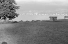
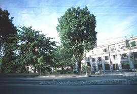
Ferguson Point including plaque
- COV-S639-3-F24-: CVA 792-449
- Item
- [Nov. 1985?]
Part of City of Vancouver fonds
Ferguson Point including plaque
Part of City of Vancouver fonds

Part of City of Vancouver fonds
Part of City of Vancouver fonds

Part of City of Vancouver fonds
Part of City of Vancouver fonds

Part of City of Vancouver fonds

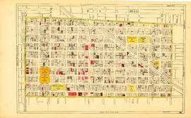
Sheet 19 : Maple Street to Richards Street and Drake Street to Third Avenue
Part of City of Vancouver fonds
Item is a section showing Maple Street to Richards Street and Drake Street to Third Avenue. Includes streets, roads, blocks, lots, legal descriptions, parks, schools, the Burrard and Granville Street Bridges, C.P.R. right-of-ways, the Squamish Band reserve, C.P.R. leases and property, and government reserve. Map includes Granville Island. Map is hand coloured to show tax sale property for sale, property with no water, street widening and drainage, replotting, reserved land for schools, reserved land for parks, sundry land, capital assets not including schools and parks, schools, and parks.
Vancouver (B.C.). Office of the City Engineer

Sheet M : Granville Street to Kersland Drive and Twenty-seventh Avenue to Thirty-eighth Avenue
Part of City of Vancouver fonds
Item is a section showing the area from Granville Street to Kersland Drive and Twenty-seventh Avenue to Thirty-eighth Avenue. Includes streets and roads; blocks, lots and legal descriptions; and golf courses, parks and government buildings. The map is hand coloured to show tax sale property for sale, property with no water, street widening and drainage, replotting, reserved land for schools, reserved land for parks, sundry land, capital assets not including schools and parks, schools, and parks, as applicable.

Sheet 13 : Ontario Street to Clark Drive and First Avenue to Sixteenth Avenue
Part of City of Vancouver fonds
Item is a section showing the area from Ontario Street to Clark Drive and First Avenue to Sixteenth Avenue. Includes streets, roads, blocks, lots, legal descriptions, railways, parks and schools. Includes B.C. Electric Railway car barns. Map is hand coloured to show tax sale property for sale, property with no water, street widening and drainage, replotting, reserved land for schools, reserved land for parks, sundry land, capital assets not including schools and parks, schools, and parks. Annotations in pencil.
Vancouver (B.C.). Office of the City Engineer
Sheet 14 : Main Street to Knight Street and Fifteenth Avenue to King Edward Street
Part of City of Vancouver fonds
Item is a section showing the area from Main Street to Knight Street and Fifteenth Avenue to King Edward Street. Includes streets and roads, blocks, lots, legal descriptions, parks, schools and businesses. Map is hand coloured to show tax sale property for sale, property with no water, street widening and drainage, replotting, reserved land for schools, reserved land for parks, sundry land, capital assets not including schools and parks, schools, and parks.
Vancouver (B.C.). Office of the City Engineer

Sheet 15 : Oak Street to Main Street and False Creek to Sixteenth Avenue
Part of City of Vancouver fonds
Item is a section showing Oak Street to Main Street and False Creek to Sixteenth Avenue. Includes streets and roads, blocks, lots, legal descriptions, railways, schools, monastery, Vancouver General Hospital and City Hall. Indicates crown land leased to the C.P.R. Map is hand coloured to show tax sale property for sale, property with no water, street widening and drainage, replotting, reserved land for schools, reserved land for parks, sundry land, capital assets not including schools and parks, schools, and parks.
Vancouver (B.C.). Office of the City Engineer

Sheet 9 : Clark Drive to Slocan Street and Triumph Street to Charles Street
Part of City of Vancouver fonds
Item is a section showing the area from Clark Drive to Slocan Street and Triumph Street to Charles Street. Includes streets and roads, blocks, lots, legal descriptions, railways, parks, schools and drill hall. The Town of Hastings is indicated on the map. Some annotations have been made in pencil. Map is hand coloured to show tax sale property for sale, property with no water, street widening and drainage, replotting, reserved land for schools, reserved land for parks, sundry land, capital assets not including schools and parks, schools, and parks, as applicable.
Vancouver (B.C.). Office of the City Engineer

Sheet 17 : Trutch Street to Maple Street and Fourth Avenue to Sixteenth Avenue
Part of City of Vancouver fonds
Item is a section showing Trutch Street to Maple Street and Fourth Avenue to Sixteenth Avenue. Includes streets, roads, blocks, lots, legal descriptions, parks and schools. Annotations in pencil. Map is hand coloured to show tax sale property for sale, property with no water, street widening and drainage, replotting, reserved land for schools, reserved land for parks, sundry land, capital assets not including schools and parks, schools, and parks.
Vancouver (B.C.). Office of the City Engineer

Sheet 7 : Clark Drive to Slocan Street and Seventh Avenue to Eighteenth Avenue
Part of City of Vancouver fonds
Item is a section showing the area from Clark Drive to Slocan Street and Seventh Avenue to Eighteenth Avenue. Includes streets and roads, blocks, lots, legal descriptions, railways, parks and schools. Map is hand coloured to show tax sale property for sale, property with no water, street widening and drainage, replotting, reserved land for schools, reserved land for parks, sundry land, capital assets not including schools and parks, schools, and parks, as applicable.
Vancouver (B.C.). Office of the City Engineer

Sheet B : Imperial Street to Trutch Street and waterfront to Fourth Avenue
Part of City of Vancouver fonds
Item is a section showing the area from Imperial Street to Trutch Street and waterfront to Fourth Avenue. Includes streets, roads and sewers; blocks, lots and legal descriptions; and parks and schools. Section shows Jericho Air Station and crown leases. Map is annotated to show tax sale property for sale, property with no water, street widening and drainage, replotting, reserved land for schools, reserved land for parks, sundry land, capital assets not including schools and parks, schools, and parks, as applicable.
Vancouver (B.C.). Office of the City Engineer

Sheet C : University Endowment Lands to Imperial Street and Fourth Avenue to Sixteenth Avenue
Part of City of Vancouver fonds
Item is a section showing the area from the University Endowment Lands to Imperial Street and Fourth Avenue to Sixteenth Avenue. Includes streets, roads, blocks, lots, legal descriptions, parks and schools. Section is annotated to show tax sale property for sale, property with no water, street widening and drainage, replotting, reserved land for schools, reserved land for parks, sundry land, capital assets not including schools and parks, schools, and parks, as applicable.
Vancouver (B.C.). Office of the City Engineer

Sheet E : University Endowment Lands to Wallace Street and Sixteenth Avenue to Twenty-seventh Avenue
Part of City of Vancouver fonds
Item is a section showing the area from Wallace Street to Trafalgar Street and Sixteenth Avenue to Twenty-seventh Avenue. Includes streets, roads, blocks, lots, legal descriptions, parks and schools. Section is annotated to show tax sale property for sale, property with no water, street widening and drainage, replotting, reserved land for schools, reserved land for parks, sundry land, capital assets not including schools and parks, schools, and parks, as applicable.
Vancouver (B.C.). Office of the City Engineer

Sheet 5 : Dumfries Street to Fairmont Street and Twenty-seventh Avenue to Thirty-seventh Avenue
Part of City of Vancouver fonds
Item is a section showing the area from Dumfries Street to Fairmont Street and Twenty-seventh Avenue to Thirty-seventh Avenue. Includes streets, roads, blocks, lots, legal descriptions, parks, railway lines and schools. Map is hand coloured to show tax sale property for sale, property with no water, street widening and drainage, replotting, reserved land for schools, reserved land for parks, sundry land, capital assets not including schools and parks, schools, and parks, as applicable.
Vancouver (B.C.). Office of the City Engineer

Sheet 1 : Cambie Street to Carolina Street and Sixteenth Avenue to Twenty-eighth Avenue
Part of City of Vancouver fonds
Item is a section showing the area from Cambie Street to Carolina Street and Sixteenth Avenue to Twenty-eighth Avenue. Includes streets, roads, blocks, lots, legal descriptions, parks, nurseries and schools. Map is hand coloured to show tax sale property for sale, property with no water, street widening and drainage, replotting, reserved land for schools, reserved land for parks, sundry land, capital assets not including schools and parks, schools, and parks, as applicable.
Vancouver (B.C.). Office of the City Engineer

Part of City of Vancouver fonds
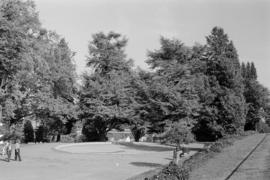
Image shows the trees on the west side of Victory Square and on the left, a small portion of the Vancouver Vocational Institute with "silver anniversary banner".

Part of City of Vancouver fonds
Image shows primarily the trees on the west side of Victory Square.
200 West Pender Street north side
Part of City of Vancouver fonds
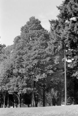
Image shows the south side of Victory Square Park.
![[Park]](/uploads/r/null/a/d/5/ad5f8deefdf643bc4cbde87ef3053fbdbfc57d871e3fa6cb83bd4b0d28ee8cae/71ede936-d2e3-4559-8b34-1f4a4d9d402b-CVA1095-13802_142.jpg)
Part of City of Vancouver fonds

Stanley Park, visitors seated on grass facing east near Bandstand
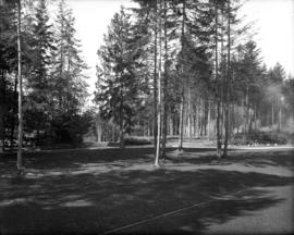
Stanley Park, cleared areas and clearing fires
Item is a photograph of a cleared area of Stanley Park with smoke from clearing fires visible in the background (mid right).

Item is a photograph of the bandstand at Alexandra Park, English Bay. Two small children walk on the grass near the bandstand and the English Bay Pier can be seen in the lower left background.
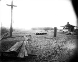
Kitsilano Beach, construction materials, bathhouse, and change stall
Item is a photograph of Kitsilano Beach, looking west towards the bathhouse. Railway tracks and utility poles are visible on the left, and lumber, piping, and unused poles are visible on the beach. There is a change stall visible on the right.
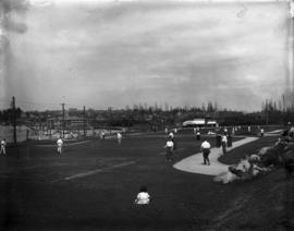
Kitsilano Beach, tennis courts
Item is a photograph of the tennis courts at Kitsilano Beach. The view is looking east across the courts at the bathhouse and beach in the background.

Item is a photograph of English Bay and the west side of Downtown Vancouver, looking northeast from somewhere along the south shore of English Bay. The view includes the Hotel Vancouver at the far right, and the beginning of Stanley Park on the far left.

Item is a photograph of a rough carved wooden sign saying "Stanley Park" resting on two logs.
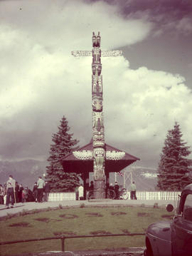
Item is a photograph of the totem pole, buildings, landscaping, and visitors at Prospect Point in Stanley Park.

Stanley Park, Shakespeare Memorial
![Wilson [Harding] memorial, Stanley Park](/uploads/r/null/6/8/e/68e3a71452408ba9791fc140e1befcb53d79722b0251cbd86632949a37835c0c/77c422b7-125a-44e2-8a8b-9850a21f7699-CVA72-53_142.jpg)
Wilson [Harding] memorial, Stanley Park
Item is a photograph of the Warren G. Harding Memorial in Stanley Park.
![[Float in the P.N.E. parade]](/uploads/r/null/5/c/5c6540cddd95d60a82ee393400dca5e99130c8100893d210d1fcca834e9a7a4c/bb65858e-700a-48a4-b937-76085fc2ffda-A37892_142.jpg)
Photograph shows a float celebrating the 59th anniversary of the opening of Stanley Park in the Pacific National Exhibition parade along Hastings Street.
![[Three beautiful girls admiring the hollow tree in Stanley Park, Vancouver, B.C.]](/uploads/r/null/8/8/e/88ef85bcc7a17953f2377f6e495445cea1491b01b9ce5669fa50244be5c9d4d7/9794cf26-d83f-4c7c-9b1d-eaf348a0747c-AM1052P-601_142.jpg)
[Three beautiful girls admiring the hollow tree in Stanley Park, Vancouver, B.C.]

Beaver Lake, Stanley Park, Vancouver, B.C.
This postcard includes personal correspondence. Sent to Mrs. E. Milton Small of Gillingham, Kent, England, from her son Harry in Vancouver.
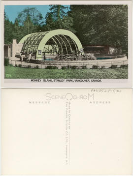
Monkey Island, Stanley Park, Vancouver, Canada
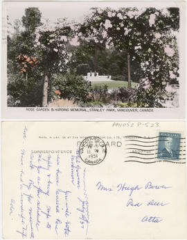
Rose Garden & Harding Memorial, Stanley Park, Vancouver, B.C.
This postcard includes personal correspondence. Sent to Mrs. Hugh Bower of Red Deer, Alberta, from Ada.


Bathing beach, English Bay, B.C.
Item is a photograph which is part of a set of twelve miniature photographic prints (AM1052 P1063.02 to AM1051 P-1063.13) depicting various scenes and sites around Vancouver. All 12 prints were contained in the envelope AM1052 P1063.01. Logo for Canadian Photo Co. is on the image.
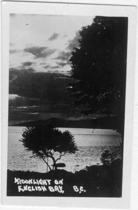
Moonlight on English Bay, B.C.
Item is a photograph which is part of a set of twelve miniature photographic prints (AM1052 P1063.02 to AM1051 P-1063.13) depicting various scenes and sites around Vancouver. All 12 prints were contained in the envelope AM1052 P1063.01.

Entrance to Stanley Park (causeway)

Entrance to Stanley Park, Vancouver, Canada

Entrance to Stanley Park, Vancouver, Canada
![[View of the ranger's cottage directly behind the entrance arch to Stanley Park]](/uploads/r/null/c/7/c78ecc2347c66879c28e7f3153f6458a0c359cce591299b2f7e2afc96ea37563/85a92948-753e-42aa-9c72-de1854bbc5b9-A37912_142.jpg)
[View of the ranger's cottage directly behind the entrance arch to Stanley Park]
![Doris Armstrong (right) and Florrie Wilson in [front of Heather] park by 3500 Willow Street[, Van...](/uploads/r/null/b/6/b661535a23da9af886769e540d2081f83175a012de95179bbc929289e6d97d74/c1102e31-4e57-4cb4-b7e9-c4219156efeb-A71403_142.jpg)
Photograph shows portion of Heather Park and houses bordering the park.
![Marion Armstrong [standing at the foot of the steps at 3500 Willow Street, Vancouver, B.C.]](/uploads/r/null/8/3/832c3d5f1545c1150be3b5f1c677ef089807a38b42412683c1c593fd6c6322e3/2265a349-ac9c-4f77-a9f5-9df86211a44d-A71400_142.jpg)
Marion Armstrong [standing at the foot of the steps at 3500 Willow Street, Vancouver, B.C.]
Photograph shows a portion of Heather Park and houses bordering the park.
![[View of the Great Northern (Union) and Canadian National Stations and Thornton Park]](/uploads/r/null/3/f/3f3bf794ce9c38103d6e1f740d743b90cf54e8f2591d95f7406a69a338615147/b1609fd1-5aca-4ca5-87bc-b899b4c76130-A63485_142.jpg)
[View of the Great Northern (Union) and Canadian National Stations and Thornton Park]
Part of Major Matthews collection
Panoramic view showing the Hotel Ivanhoe, the G.N. and C.N. freight buildings and Massey-Harris Farm Implements.
![[Aerial view of the West End showing the increase of apartment buildings west of Cardero Street]](/uploads/r/null/9/4/9410444a29ad3e6e13228ba5ad44b40986af7ad70945337641000d03b991a529/ee9fb9e8-21b9-4ca5-a5b6-d28e6d51046e-A25977_142.jpg)
[Aerial view of the West End showing the increase of apartment buildings west of Cardero Street]
Part of Major Matthews collection
Photograph shows oblique view of Lost Lagoon, Stanley Park and Lord Roberts School
![[Aerial view of Vancouver]](/uploads/r/null/b/9/b973b9a4143a5316b02e728c35d99e383f27a3db21d8e20aa7bbb459780243bc/3ff38b56-6b36-4c17-bce1-329c97459d29-A66598_142.jpg)
Part of Major Matthews collection
Photograph shows Kitsilano, Kits Point, Kitsilano Beach, R.C.A.F. Equipment Depot, Kitsilano Pool, Burrard Bridge, C.P.R. Kitsilano Trestle, Granville Island, Granville Bridge, Cambie Bridge, False Creek, C.P.R. False Creek Yards, West End, Yaletown, Arbutus Ridge, Shaughnessy, South Cambie, Fairview, Mount Pleasant, Little Mountain Reservoir, Connaught Park, Quilchena Golf Course, Douglas Park, Shaughnessy Heights Golf Course, Queen Elizabeth Park, Royal Canadian Mounted Police Barracks, Shaughnessy Military Hospital, Hillcrest Park, Robertson & Hacket Sawmill, City Yard, West Coast Ship Builders and Athletic Park.