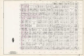
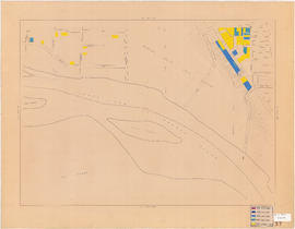
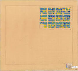
Sheet 3 : Cambie Street to St. George Street and Twenty-seventh Avenue to Thirty-eighth Avenue
- COV-S303-MAP 343-: MAP 343.49
- Item
- [ca. 1925], with revisions to [ca. 1945]
Part of City of Vancouver fonds
Item is a section showing the area from Cambie Street to St. George Street and Twenty-seventh Avenue to Thirty-eighth Avenue. Map shows streets, roads, blocks, lots and legal descriptions and the locations of parks, schools, reservoirs and Mountainview Cemetery. Map is hand coloured to show tax sale property for sale, property with no water, street widening and drainage, replotting, reserved land for schools, reserved land for parks, sundry land, capital assets not including schools and parks, schools, and parks, as applicable.
Vancouver (B.C.). Office of the City Engineer


![[View of Mount Pleasant]](/uploads/r/null/0/c/9/0c9db5e81df211f273f5e890c4cf2f482734489cf47c53831e2f430410336c9b/259201ec-18df-4a3e-9317-7b6aa211e33b-CVA808-9_142.jpg)
![[House at] 743 East Pender Street](/uploads/r/null/c/7/c7cb8ee7375a3f7c85b16d6bcac69252f03f7c76ae6b935d36a1953256db0d03/347d091d-7104-4d2a-813d-8f7daf51862c-A61546_142.jpg)
![[House at 727] Keefer Street](/uploads/r/null/c/4/c41bd7532c24c871c2ed8be83f67d581b21d06c4e1819f00079cee73d5982dea/4602d0e0-b009-4c67-8272-e4286b496b86-A61552_142.jpg)
![[Buildings at] 886-898 Union Street](/uploads/r/null/0/9/0998c98e83ff573660605fb2e05e845a11f9807872f6f8eef620b2160352a8aa/78776bb6-68ae-449c-b26d-449b666e881b-A61555_142.jpg)
![[Buildings at] 606 Union Street](/uploads/r/null/5/5/556bc3293559172a8a9849d9d55ac756b4c21caeeb58ffa5b2f607753cb9d958/61a17ec4-7c57-489e-8c5c-7c0726a3c713-A61558_142.jpg)
![[Buildings at] 606 Union Street](/uploads/r/null/b/0/b057b3e56c0a625078b403bddd58250fc8e9ae22c257d73f648900eaaf78e740/70639922-761f-473b-84b4-065c3025f125-A61559_142.jpg)


![City of Vancouver B.C. area map [Cartier St. to 49th Ave. to Wallace St. to Fraser River]](/uploads/r/null/b/9/0/b90512d5b7ab999c429946e004afaeefa347e648d05cbe127e548941cf053492/4bf26a05-6451-4c58-be1b-4491a36347e0-LEG1493_142.jpg)
![City of Vancouver B.C. area map [Inverness St. to 37th Ave. to Granville St. to 57th Ave.]](/uploads/r/null/b/b/b/bbb5627e84fb0e74ba863c698c350f1c776909c66fe285c49945f91a0bde6e48/94cc8c2d-2d95-4552-a8e4-3a917b38ed69-LEG1493_142.jpg)


![C.B.D. [Central Business District] trip trace density chart](/uploads/r/null/6/b/4/6b4dfcd5710a8add68045b374b1df6e0649e8577a53d23070c9494276c76c3fd/0e0776f3-ca72-4c99-8121-6e7293b90cee-LEG26_142.jpg)


![City of Vancouver [Distribution of retail sales and receipts of service establishments - 1951]](/uploads/r/null/3/9/7/3970537d0d8596140313dc84373e73334a52dfd423812f8ed746f90efd77b050/00738a9c-eac0-4b16-8878-f50deae7c4ee-LEG26_142.jpg)

![City of Vancouver [Existing super-markets : date of erection, size and location]](/uploads/r/null/c/9/9/c994b91e283c9d37d539b5381734a5b8dd287c7cc8da9ba54b10a82d884e42b2/99137e02-fef1-48fe-8563-9abd1c74c42f-LEG1202_142.jpg)
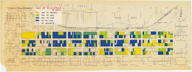
![Age of bldgs. [buildings] : 1000-1300 Granville Street](/uploads/r/null/f/6/1/f616b7dd30e14793c36bdae78e7ac9d8a918586b9b1b461a4888b74a53c4c228/3f061937-ef69-4bc5-81ce-d99a0ad6e7ce-LEG1202_142.jpg)