Showing 144 results

Archival description
City of Vancouver fonds Vancouver (B.C.). Planning Department
Print preview View:

104 results with digital objects Show results with digital objects

Heritage inventory 1986 : photograph surveys

Series consists of three sets of photographic surveys which were carried out to assist the heritage designation and evaluation process resulting in the revised 1986 heritage inventory. The three sets are arranged in the following subseries:

  • Survey 1 - buildings
  • Survey 2 - public nominations
  • Survey 3 - parks, landscaping, and monuments

Vancouver (B.C.). Planning Department

Open Data Catalogue : heritage property data : October 2017

File consists of datasets containing information on properties or sites given heritage status or recognition. File also contains Open Data Catalogue html pages that described the datasets; pages include data attributes and data accuracy and currency information. Datasets are as they appeared on October 4, 2017.

Vancouver (B.C.). Planning Department
Open Data Catalogue : heritage property data : January 2018

File consists of datasets containing information on properties or sites given heritage status or recognition. File also contains Open Data Catalogue html pages that described the datasets; pages include data attributes and data accuracy and currency information. Datasets are as they appeared on January 8, 2018.

Vancouver (B.C.). Planning Department

Open Data Catalogue : local area boundary : January 2018

File consists of datasets showing boundaries of Vancouver's 22 local areas, also known as local planning areas. File also contains Open Data Catalogue html page that described the datasets; page includes data attributes and data accuracy and currency information. Datasets are as they appeared on January 8, 2018.

Vancouver (B.C.). Information Technology Department

Open Data Catalogue : heritage property data : April 2018

File consists of datasets containing information on properties or sites given heritage status or recognition. File also contains Open Data Catalogue html pages that described the datasets; pages include data attributes and data accuracy and currency information. Datasets are as they appeared on April 3, 2018.

Vancouver (B.C.). Planning Department

Open Data Catalogue : census local area profiles 2006 : October 2014

File consists of datasets provided by Statistics Canada from the 2006 Census as a custom profile data order for the City of Vancouver, using the City's 22 local planning areas. Datasets contain demographic information by local area. File also contains Open Data Catalogue html pages that described the datasets; pages include data attributes and data accuracy and currency information. Datasets are as they appeared on October 22, 2014.

Vancouver (B.C.). Planning Department

Open Data Catalogue : local area boundary : October 2014

File consists of datasets showing boundaries of Vancouver's 22 local areas, also known as local planning areas. File also contains Open Data Catalogue html page that described the datasets; page includes data attributes and data accuracy and currency information. Datasets are as they appeared on October 22, 2014.

Vancouver (B.C.). Information Technology Department

Open Data Catalogue : census local area profiles 2011 : April 2015

File consists of datasets provided by Statistics Canada from the 2011 Census as a custom profile data order for the City of Vancouver, using the City's 22 local planning areas. Datasets contain demographic information by local area. File also contains Open Data Catalogue html pages that described the datasets; pages include data attributes and data accuracy and currency information. Datasets are as they appeared on April 1, 2015.

Vancouver (B.C.). Planning Department

Open Data Catalogue : census local area profiles 2006 : July 2015

File consists of datasets provided by Statistics Canada from the 2006 Census as a custom profile data order for the City of Vancouver, using the City's 22 local planning areas. Datasets contain demographic information by local area. File also contains Open Data Catalogue html pages that described the datasets; pages include data attributes and data accuracy and currency information. Datasets are as they appeared on July 7, 2015.

Vancouver (B.C.). Planning Department

Open Data Catalogue : census local area profiles 2011 : July 2015

File consists of datasets provided by Statistics Canada from the 2011 Census as a custom profile data order for the City of Vancouver, using the City's 22 local planning areas. Datasets contain demographic information by local area. File also contains Open Data Catalogue html pages that described the datasets; pages include data attributes and data accuracy and currency information. Datasets are as they appeared on July 7, 2015.

Vancouver (B.C.). Planning Department

Open Data Catalogue : census local area profiles 2001 : April 2016

File consists of datasets provided by Statistics Canada from the 2001 Census as a custom profile data order for the City of Vancouver, using the City's 22 local planning areas. Datasets contain demographic information by local area. File also contains Open Data Catalogue html pages that described the datasets; pages include data attributes and data accuracy and currency information. Datasets are as they appeared on April 1, 2016.

Vancouver (B.C.). Planning Department

Open Data Catalogue : heritage property data : May 2017

File consists of datasets containing information on properties or sites given heritage status or recognition. File also contains Open Data Catalogue html pages that described the datasets; pages include data attributes and data accuracy and currency information. Datasets are as they appeared on May 26, 2017.

Vancouver (B.C.). Planning Department

Open Data Catalogue : local area boundary : May 2017

File consists of datasets showing boundaries of Vancouver's 22 local areas, also known as local planning areas. File also contains Open Data Catalogue html page that described the datasets; page includes data attributes and data accuracy and currency information. Datasets are as they appeared on May 26, 2017.

Vancouver (B.C.). Information Technology Department

Open Data Catalogue : local area boundary : January 2017

File consists of datasets showing boundaries of Vancouver's 22 local areas, also known as local planning areas. File also contains Open Data Catalogue html page that described the datasets; page includes data attributes and data accuracy and currency information. Datasets are as they appeared on January 3, 2017.

Vancouver (B.C.). Information Technology Department

Open Data Catalogue : census local area profiles 2011 : March 2013

File consists of datasets provided by Statistics Canada from the 2011 Census as a custom profile data order for the City of Vancouver, using the City's 22 local planning areas. Datasets contain demographic information by local area. Datasets are as they appeared on March 13, 2013.

Vancouver (B.C.). Planning Department

Open Data Catalogue : census local area profiles 2011 : May 2013

File consists of datasets provided by Statistics Canada from the 2011 Census as a custom profile data order for the City of Vancouver, using the City's 22 local planning areas. Datasets contain demographic information by local area. Datasets are as they appeared on May 1, 2013.

Vancouver (B.C.). Planning Department

Open Data Catalogue : census local area profiles 2001 : August 2013

File consists of datasets provided by Statistics Canada from the 2001 Census as a custom profile data order for the City of Vancouver, using the City's 22 local planning areas. Datasets contain demographic information by local area. Datasets are as they appeared on August 12, 2013.

Vancouver (B.C.). Planning Department

Open Data Catalogue : census local area profiles 2006 : August 2013

File consists of datasets provided by Statistics Canada from the 2006 Census as a custom profile data order for the City of Vancouver, using the City's 22 local planning areas. Datasets contain demographic information by local area. Datasets are as they appeared on August 12, 2013.

Vancouver (B.C.). Planning Department

Open Data Catalogue : census local area profiles 2006 : November 2013

File consists of datasets provided by Statistics Canada from the 2006 Census as a custom profile data order for the City of Vancouver, using the City's 22 local planning areas. Datasets contain demographic information by local area. Datasets are as they appeared on November 25, 2013.

Vancouver (B.C.). Planning Department

Open Data Catalogue : census local area profiles 2006 : February 2014

File consists of datasets provided by Statistics Canada from the 2006 Census as a custom profile data order for the City of Vancouver, using the City's 22 local planning areas. Datasets contain demographic information by local area. Datasets are as they appeared on February 28, 2014.

Vancouver (B.C.). Planning Department

Open Data Catalogue : heritage property data : July 2016

File consists of datasets containing information on properties or sites given heritage status or recognition. File also contains Open Data Catalogue html pages that described the datasets; pages include data attributes and data accuracy and currency information. Datasets are as they appeared on July 12, 2016.

Vancouver (B.C.). Planning Department

Zoning and Development By-law amendment records

Series consists of records documenting proposed and initiated amendments to the main text, appendices and schedules of Vancouver's Zoning and Development By-law (No. 3575) and its predecessor Zoning By-law (no. 2516 ). The series does not contain by-law amendments relating to individual properties.

The series consists of inter-departmental and external correspondence; reports to Board of Administration, Council and Standing Committees; and intra-departmental memoranda documenting discussions re: the need for specific amendments, the wording of proposed amendments, and drafts of proposed amendments to the by-law.

The series also includes records documenting the creation and deletion of building lines. As of the passage of By-law no. 3575, this was accomplished by means of revisions to Appendix E of the by-law; before this, building lines were established by Planning Department policy.

Vancouver (B.C.). Planning Department

Built heritage research records

Series consists of records documenting research conducted by Heritage Planners and private heritage contractors working on behalf of the Planning Department into the heritage features of various structures in the City of Vancouver. The structures documented are primarily buildings.

Files in the series may contain any or all of the following on a particular structure: correspondence and memoranda, photographs, survey forms, architectural survey forms, beautification building survey data forms, architectural or technical drawings, and general notes on history, condition, assessed value, etc. Many of the forms include one or more small photographs.

Vancouver (B.C.). Planning Department

Planning Department maps, plans and drawings

Series consists of maps, plans, drawings, charts and photographs created, amended or used by the Planning Department in the course of drafting ideas, compiling information, preparing displays, or designing publication copy relating to planning activities, including rezoning considerations. This series is divided into 3 subseries:

(1) Paper
(2) Microfiche copies - chronological set
(3) Microfiche copies - local areas set

There may be instances of overlap between the retained originals and the microfiche copies.

Vancouver (B.C.). Planning Department

Aerial survey cronaflex positives and paper prints

Series consists of cronaflex stereoscapic aerial survey photographs used for data collection to support planning and engineering activities. The photographs were created by a variety of photographic firms, under contract for the Planning Department. The series includes index maps for many of the flights. Some years are incomplete.

Vancouver (B.C.). Planning Department

Overall Planning Division data project printouts

Series consists of computer printouts of primarily business license, development permit and building permit data, relating to the preparation of analyses of building characteristics and business, development, and land use activities. Printouts used as source material for articles in the Quarterly Review (PDS 29) and for the Vancouver Coreplan. Arranged alphabetically by printout title.

Vancouver (B.C.). Planning Department

Peak hour bus volumes

Item consists of a map depicting the locations of bus stops in the downtown area, with scaled lines that most likely depict volume of bus services during rush hour.

Vancouver (B.C.). Planning Department

Strata title conversion files

Series consists of correspondence and plans relating to development permit applications. Arranged alphabetically by street address.

Vancouver (B.C.). Planning Department

Planning operational records

Series documents the core planning functions performed by the Planning Department, including land use and development planning, administering the Zoning and Development By-law and related by-laws, and providing advice on planning matters to other City units, Council and the Mayor's Office.

Records in this series consist of subject and project files relating to non-Heritage matters which were the responsibility of the Department. Subject titles corresponding to blocks in the departmental file plan have been retained as the first part of file titles.

Vancouver (B.C.). Planning Department

Taken from Comox and Bidwell streets looking towards English Bay

Item consists of a photograph depicting a model created by Planning Department staff to study view obstructions which result from various building configurations, based on different options to be included in zoning regulations for the West End.

Vancouver (B.C.). Planning Department

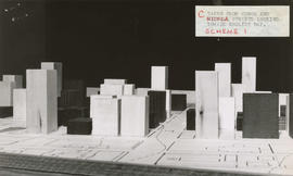
Taken from Comox and Nicola streets looking towards English Bay

Item consists of a photograph depicting a model created by Planning Department staff to study view obstructions which result from various building configurations, based on different options to be included in zoning regulations for the West End.

Vancouver (B.C.). Planning Department

Planning Department film collection

Series consists of films or copies of films collected by the Planning Department, and related to the City and regional planning of the 1960s: urban renewal, downtown planning, and harbour development. Arranged chronologically. The films were presented by the City of Vancouver. Films were produced by Pageant Productions Ltd. of Vancouver for the National Film Board of Canada.

Vancouver (B.C.). Planning Department

Demolished and redeveloped heritage properties files

Series consists of building case files concerning permits to demolish heritage designated buildings typically containing heritage evaluation forms including photographs, as well as various reports, correspondence, news clippings, etc. Arranged alphabetically by address.

Vancouver (B.C.). Planning Department

Heritage evaluation forms : deletions from register (buildings demolished for redevelopment)

Series consists of heritage evaluation forms on buildings deleted from the heritage register because the building has been demolished. The request for a deletion originates from the applicant for a development permit where that redevelopment entails demolition of the existing building(s). Once the development permit is approved because there is no possibility of keeping the building through negotiation with the owner, demolition is permitted. Arranged by street address.

Vancouver (B.C.). Planning Department

Open Data Catalogue : census local area profiles 2011 : April 2016

File consists of datasets provided by Statistics Canada from the 2011 Census as a custom profile data order for the City of Vancouver, using the City's 22 local planning areas. Datasets contain demographic information by local area. File also contains Open Data Catalogue html pages that described the datasets; pages include data attributes and data accuracy and currency information. Datasets are as they appeared on April 1, 2016.

Vancouver (B.C.). Planning Department

Open Data Catalogue : heritage property data : April 2019

File consists of datasets containing information on properties or sites given heritage status or recognition. File also contains Open Data Catalogue html pages that described the datasets; pages include data attributes and data accuracy and currency information. Datasets are as they appeared on April 2, 2019.

Vancouver (B.C.). Planning Department

Open Data Catalogue : heritage property data : July 2015

File consists of datasets containing information on properties or sites given heritage status or recognition. File also contains Open Data Catalogue html pages that described the datasets; pages include data attributes and data accuracy and currency information. Datasets are as they appeared on July 7, 2015.

Vancouver (B.C.). Planning Department

Open Data Catalogue : local area boundary : July 2015

File consists of datasets showing boundaries of Vancouver's 22 local areas, also known as local planning areas. File also contains Open Data Catalogue html page that described the datasets; page includes data attributes and data accuracy and currency information. Datasets are as they appeared on July 7, 2015.

Vancouver (B.C.). Information Technology Department

Open Data Catalogue : census local area profiles 2011 : October 2015

File consists of datasets provided by Statistics Canada from the 2011 Census as a custom profile data order for the City of Vancouver, using the City's 22 local planning areas. Datasets contain demographic information by local area. File also contains Open Data Catalogue html pages that described the datasets; pages include data attributes and data accuracy and currency information. Datasets are as they appeared on October 6, 2015.

Vancouver (B.C.). Planning Department

Open Data Catalogue : census local area profiles 2011 : January 2016

File consists of datasets provided by Statistics Canada from the 2011 Census as a custom profile data order for the City of Vancouver, using the City's 22 local planning areas. Datasets contain demographic information by local area. File also contains Open Data Catalogue html pages that described the datasets; pages include data attributes and data accuracy and currency information. Datasets are as they appeared on January 20, 2016.

Vancouver (B.C.). Planning Department

Results 51 to 100 of 144