Showing 280 results
Archival description280 results with digital objects Show results with digital objects

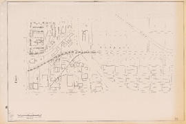
Sectional map of Vancouver showing streets, block and lot outlines, and building perimeters : Map 33 : Clark Drive to Nanaimo Street and 2nd Avenue to 13th Avenue
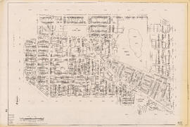
Sectional map of Vancouver showing streets, block and lot outlines, and building perimeters : Map 40 : Inverness Street to Nanaimo Street and 13th Avenue to 22nd Avenue/24th Avenue

Sectional map of Vancouver showing streets, block and lot outlines, and building perimeters : Map 42 : Oak Street to Ontario Street and 16th Avenue to 28th Avenue

Sectional map of Vancouver showing streets, block and lot outlines, and building perimeters : Map 43 : East Boulevard to Oak Street and 14th Avenue to Laurier Avenue

Sectional map of Vancouver showing streets, block and lot outlines, and building perimeters : Map 46 : Blanca Street to Discovery Street and 14th Avenue to 16th Avenue

Sectional map of Vancouver showing streets, block and lot outlines, and building perimeters : Map 49 : Arbutus Street to Oak Street and Laurier Avenue to 33rd Avenue
Sectional map of Vancouver showing streets, block and lot outlines, and building perimeters : Map 50 : Oak Street to Ontario Street and 28th Avenue to 37th Avenue

Sectional map of Vancouver showing streets, block and lot outlines, and building perimeters : Map 58 : Inverness Street to Berkley Street/Nanaimo Street and 41st Avenue to 49th Avenue

Sectional map of Vancouver showing streets, block and lot outlines, and building perimeters : Map 67 : Musqueam Indian Reserve and Shaughnessy Golf Course

Sectional map of Vancouver showing streets, block and lot outlines, and building perimeters : Map 69 : Wallace Street to MacDonald Street and 49th Avenue to the North Arm of the Fraser River

Sectional map of Vancouver showing streets, block and lot outlines, and building perimeters : Map 73 : Quebec Street to Inverness Street and 47th Avenue to 57th Avenue

Sectional map of Vancouver showing streets, block and lot outlines, and building perimeters : Map 75 : Nanaimo Street to Kerr Street and 49th Avenue to Bobolink Avenue

Sectional map of Vancouver showing streets, block and lot outlines, and building perimeters : Map 80 : Inverness Street to Gladstone Street/Nanaimo Street and 61st Avenue to the North Fork of the North Arm of the Fraser River

Sectional map of Vancouver showing streets, block and lot outlines, and building perimeters : Map 81 : Main Street to Inverness Street and 57th Avenue to S.E. Marine Drive

Sectional map of Vancouver showing streets, block and lot outlines, and building perimeters : Map 83 : Fremlin Street to Main Street and 57th Avenue to 67th Avenue/S.W. Marine Drive

Sectional map of Vancouver showing streets, block and lot outlines, and building perimeters : Map 90 : Iona Island to Wood Island and Celtic Avenue to Sea Island

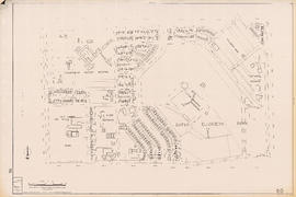
Stanley Park map and guide : park map showing trails, amenities, and recreation sites

One way streets : illustrations of special intersections

City of Vancouver, B.C. area map : Inverness Street to Boundary Road 54th Avenue to the North Arm of the Fraser River

City of Vancouver, B.C. area map : Granville Street to Inverness Street and 6th Avenue to 37th Avenue

City of Vancouver, B.C. area map : Wallace Street to Cartier Street and 49th Avenue to the North Arm of the Fraser River

City of Vancouver, B.C. area map : western boundary with University Endowment Lands to Camosun Street and English Bay to 16th Avenue; Musqueam Indian Reserve no. 2
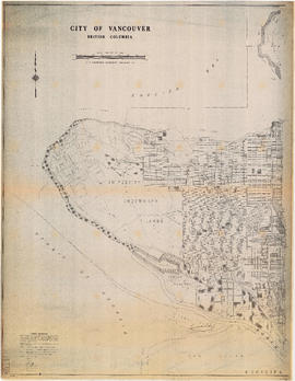
City of Vancouver, British Columbia : Point Grey to Cypress Street

Cycling in Vancouver

Stanley Park map and guide : park history, food services, and general information

Vancouver Parks and Recreation : a guide to services
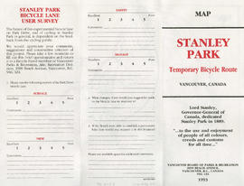
Stanley Park bicycle lane user survey

City of Vancouver, B.C. area map : Heatley Avenue to Boundary Road and Burrard Inlet to 2nd Avenue/5th Avenue

City of Vancouver, B.C. area map : Inverness Street to Boundary Road and 2nd Avenue/5th Avenue to 32nd Avenue

City of Vancouver, B.C. area map : Cartier Street to Inverness Street and 57th Avenue to the North Fork of the North Arm of the Fraser River

City of Vancouver, B.C. area map : Discovery Street to Granville Street and English Bay to King Edward Avenue

City of Vancouver, B.C. area map : Camosun Street to Granville Street and King Edward Avenue to 49th Avenue
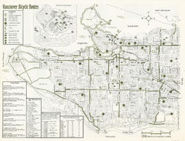
Vancouver bicycle routes

Cycling in Vancouver

Sectional map of Vancouver showing streets, block and lot outlines, and building perimeters: Map 5 : Lagoon Street to Nicola Street and Robson Street to English Bay
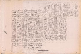
Sectional map of Vancouver showing streets, block and lot outlines, and building perimeters : Map 6 : Nicola Street to Beatty Street and Georgia Street to Beach Avenue/Drake Street

Sectional map of Vancouver showing streets, block and lot outlines, and building perimeters : Map 8 : Piers at Burrard Inlet between Main Street and Clark Drive

Sectional map of Vancouver showing streets, block and lot outlines, and building perimeters : Map 9 : Main Street to Clark Drive and Burrard Inlet to Prior Street

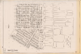
Sectional map of Vancouver showing streets, block and lot outlines, and building perimeters : Map 20 : Main Street to Clark Drive and Prior Street to 2nd Avenue/Great Northern Way
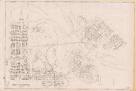
Sectional map of Vancouver showing streets, block and lot outlines, and building perimeters : Map 22 : Maple Street to Drake Street and Vanier Park/Sunset Beach to 4th Avenue

Sectional map of Vancouver showing streets, block and lot outlines, and building perimeters : Map 24 : Jericho Beach Park to Balaclava Street and English Bay to 4th Avenue
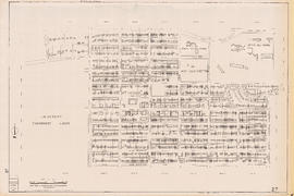
Sectional map of Vancouver showing streets, block and lot outlines, and building perimeters : Map 27 : Blanca Street to Camosun Street and 4th Avenue to 14th Avenue
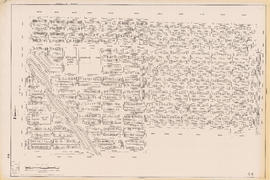
Sectional map of Vancouver showing streets, block and lot outlines, and building perimeters : Map 35 : Rupert Street to Boundary Road and 5th Avenue to Grandview Highway
Sectional map of Vancouver showing streets, block and lot outlines, and building perimeters : Map 37 : Rupert Street to Boundary Road and 22nd Avenue to Wellington Avenue/Monmouth Avenue
Sectional map of Vancouver showing streets, block and lot outlines, and building perimeters : Map 44 : Blenheim Street to Arbutus Street and 14th Avenue to King Edward Avenue/23rd Avenue

Sectional map of Vancouver showing streets, block and lot outlines, and building perimeters : Map 48 : Blenheim Street to Arbutus Street King Edward Avenue/23rd Avenue ro 33rd Avenue
Sectional map of Vancouver showing streets, block and lot outlines, and building perimeters : Map 51 : Ontario Street to Inverness Street and 28th Avenue to 37th Avenue

Sectional map of Vancouver showing streets, block and lot outlines, and building perimeters : Map 52 : Inverness Street to Nanaimo Street and 22nd Avenue/24th Avenue to 32nd Avenue

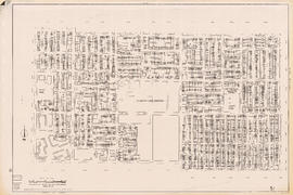
Sectional map of Vancouver showing streets, block and lot outlines, and building perimeters : Map 55 : McHardy Street/Cecil Street to Boundary Road and Wellington Avenue/Monmouth Avenue to Kingsway

Sectional map of Vancouver showing streets, block and lot outlines, and building perimeters : Map 57 : Berkley Street/Nanaimo Street to Joyce Street/Doman Street and 41st Avenue to 49th Avenue
Results 51 to 100 of 280