
British Columbia - Vancouver skyline
- AM1435-: CVA 1435-40
- Item
- [197-?]
Item is aerial photograph of downtown Vancouver looking north west towards Stanley Park.
British Columbia - Vancouver skyline
Item is aerial photograph of downtown Vancouver looking north west towards Stanley Park.

British Columbia - Vancouver skyline
Item is aerial photograph showing a panoramic view of downtown Vancouver looking north west towards Stanley Park and Coal Harbour.

British Columbia - Vancouver skyline
Item is photograph showing downtown Vancouver looking north west towards Stanley Park and Coal Harbour.

British Columbia - Vancouver skyline
Item is photograph showing buildings in downtown Vancouver looking north west towards Stanley Park and Coal Harbour.
British Columbia - Vancouver skyline
Item is photograph showing Stanley Park and Coal Harbour.

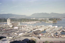
British Columbia - Vancouver skyline : view from north side of Westcoast bldg
Item is photograph showing view of Coal Harbour and Stanley Park from Westcoast Energy building.
British Columbia - Vancouver skyline : view from north side of Westcoast bldg
Item is photograph showing view Coal Harbour and Stanley Park from Westcoast Energy building.

British Columbia - Vancouver skyline : view from north side of Westcoast bldg
Item is photograph showing view of Coal Harbour and Stanley Park from Westcoast Energy building.
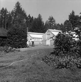
Greenhouses at Stanley Park, installation of gas lights

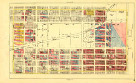
Sheet L : Trafalgar Street to Granville Street and Nanton Avenue to Thirty-eighth Avenue
Part of City of Vancouver fonds
Item is a section showing the area from Trafalgar Street to Granville Street and Nanton Avenue to Thirty-eighth Avenue. Includes streets, roads and sewers; blocks, lots and legal descriptions; and parks, golf courses and schools. The map is hand coloured to show tax sale property for sale, property with no water, street widening and drainage, replotting, reserved land for schools, reserved land for parks, sundry land, capital assets not including schools and parks, schools, and parks, as applicable.
Vancouver (B.C.). Office of the City Engineer

Sheet 11 : Carrall Street to Clark Drive and waterfront to Keefer Street
Part of City of Vancouver fonds
Item is a section showing the area from Carrall Street to Clark Drive and waterfront to Keefer Street. Includes streets and roads, blocks, lots, legal descriptions, railways, parks, schools, freight sheds, warehouses, piers and businesses along the waterfront.Map is hand coloured to show tax sale property for sale, property with no water, street widening and drainage, replotting, reserved land for schools, reserved land for parks, sundry land, capital assets not including schools and parks, schools, and parks, as applicable.
Vancouver (B.C.). Office of the City Engineer

Sheet 17 : Argyle Street to Vivian Street and Sixty-second Avenue to Kent Street
Part of City of Vancouver fonds
Item is a section showing the area from Argyle Street to Vivian Street and Sixty-second Avenue to Kent Street. Includes streets, roads, blocks, lots, legal descriptions and golf courses. Map is hand coloured to show tax sale property for sale, property with no water, street widening and drainage, replotting, reserved land for schools, reserved land for parks, sundry land, capital assets not including schools and parks, schools, and parks, as applicable. "22, 23, 25 to 33, 35, 36/258-329" is written in ink at the top of the map.
Vancouver (B.C.). Office of the City Engineer

Sheet 12 : Ontario Street to Clark Drive and Keefer Street to Second Avenue
Part of City of Vancouver fonds
Item is a section showing the area from Ontario Street to Clark Drive and Keefer Street to Second Avenue. Includes streets, roads, blocks, lots, legal descriptions, railways, parks and schools. Includes Terminal Avenue and land used by the Great Northern Railway and the Canadian National Railway. Map is hand coloured to show tax sale property for sale, property with no water, street widening and drainage, replotting, reserved land for schools, reserved land for parks, sundry land, capital assets not including schools and parks, schools, and parks, as applicable.
Vancouver (B.C.). Office of the City Engineer

Sheet 5 : Slocan Street to Boundary Road and Seventeenth Avenue to Twenty-ninth Avenue
Part of City of Vancouver fonds
Item is a section showing the area from Slocan Street to Boundary Road and Seventeenth Avenue to Twenty-ninth Avenue. Includes streets and roads, blocks, lots, legal descriptions, railways, parks, schools and the Vancouver Preventorium (for tuberculosis patients). Some annotations have been made in pencil. Map is hand coloured to show tax sale property for sale, property with no water, street widening and drainage, replotting, reserved land for schools, reserved land for parks, sundry land, capital assets not including schools and parks, schools, and parks, as applicable.
Vancouver (B.C.). Office of the City Engineer
Sheet 4 : Slocan Street to Boundary Road and Seventh Avenue to Seventeenth Avenue
Part of City of Vancouver fonds
Item is a section showing the area from Slocan Street to Boundary Road and Seventh Avenue to Seventeenth Avenue. Map is hand coloured to show tax sale property for sale, property with no water, street widening and drainage, replotting, reserved land for schools, reserved land for parks, sundry land, capital assets not including schools and parks, schools, and parks, as applicable. Includes streets and roads, blocks, lots, legal descriptions, railways, parks and schools.
Vancouver (B.C.). Office of the City Engineer

Sheet 3 : Slocan Street to Boundary Road and Seventh Avenue to Charles Street
Part of City of Vancouver fonds
Item is a section showing the area from Slocan Street to Boundary Road and Seventh Avenue to Charles Street. Includes streets and roads, blocks, lots, legal descriptions, parks and schools. Map is hand coloured to show tax sale property for sale, property with no water, street widening and drainage, replotting, reserved land for schools, reserved land for parks, sundry land, capital assets not including schools and parks, schools, and parks, as applicable.
Vancouver (B.C.). Office of the City Engineer

Sheet K : Wallace Street to Trafalgar Street and Twenty-seventh Street to Thirty-eighth Avenue
Part of City of Vancouver fonds
Item is a section showing the area from Wallace Street to Trafalgar Street and Twenty-seventh Street to Thirty-eighth Avenue. Includes streets, roads and sewers; blocks, lots and legal descriptions; and parks and schools. Section is annotated to show tax sale property for sale, property with no water, street widening and drainage, replotting, reserved land for schools, reserved land for parks, sundry land, capital assets not including schools and parks, schools, and parks, as applicable.
Vancouver (B.C.). Office of the City Engineer

Sheet 7 : Cambie Street to St. George Street and Thirty-seventh Avenue to Forty-eighth Avenue
Part of City of Vancouver fonds
Item is a section showing the area from Cambie Street to St. George Street and Thirty-seventh Avenue to Forty-eighth Avenue. Includes streets, roads, blocks, lots, legal descriptions, parks, cemeteries, and schools. Map is hand coloured to show tax sale property for sale, property with no water, street widening and drainage, replotting, reserved land for schools, reserved land for parks, sundry land, capital assets not including schools and parks, schools, and parks, as applicable.
Vancouver (B.C.). Office of the City Engineer

Sheet 14 : Ash Street to St. George Street and Marine Drive to Fraser River
Part of City of Vancouver fonds
Item is a section showing the area from Ash Street to St. George Street and Marine Drive to Fraser River. Includes streets, roads, blocks, lots, legal descriptions, parks and railway lines. Map is hand coloured to show tax sale property for sale, property with no water, street widening and drainage, replotting, reserved land for schools, reserved land for parks, sundry land, capital assets not including schools and parks, schools, and parks, as applicable.
Vancouver (B.C.). Office of the City Engineer

Sheet 12 : Prince Edward Street to Bruce Street and Forty-seventh Avenue to Fifty-eighth Avenue
Part of City of Vancouver fonds
Item is a section showing the area from Prince Edward Street to Bruce Street and Forty-seventh Avenue to Fifty-eighth Avenue. Includes streets, roads, blocks, lots, legal descriptions, parks and schools. Map is hand coloured to show tax sale property for sale, property with no water, street widening and drainage, replotting, reserved land for schools, reserved land for parks, sundry land, capital assets not including schools and parks, schools, and parks, as applicable.
Vancouver (B.C.). Office of the City Engineer

Sheet 8 : Prince Edward Street to Bruce Street and Thirty-fifth Avenue to Forty-seventh Avenue
Part of City of Vancouver fonds
Item is a section showing the area from Prince Edward Street to Bruce Street and Thirty-fifth Avenue to Forty-seventh Avenue. Includes streets, roads, blocks, lots, legal descriptions, and cemeteries, parks and schools. Map is hand coloured to show tax sale property for sale, property with no water, street widening and drainage, replotting, reserved land for schools, reserved land for parks, sundry land, capital assets not including schools and parks, schools, and parks, as applicable.
Vancouver (B.C.). Office of the City Engineer

Part of City of Vancouver fonds
Images primarily shows the trees on the west side of Victory Square.

Part of City of Vancouver fonds
Image shows a view along Hastings Street (including the Woodwards Building) and the west side of Victory Square.
200 West Hastings Street south side
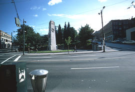
Part of City of Vancouver fonds
Image shows Victory Square from the north side, the cenotaph, and a shaded view up Hamilton Street.

Part of City of Vancouver fonds
Photograph also shows the Bloedel Conservatory dome
![Q[ueen] E[lizabeth] Park](/uploads/r/null/a/1/a1af7f4ff47c2cec6a48b65b8ee004411c3c070f3dbddba831d491edbe07c5a9/ce6747ae-853a-43ba-a713-17ef4b6e9e37-A59151_142.jpg)
Part of City of Vancouver fonds
![[Bloedel Conservatory in Queen Elizabeth Park]](/uploads/r/null/f/1/f17e7712fad68dfe1b41cad0be39cda96599122f1b5ceafdcdc354738bc9f9c4/f2fed0a8-a6b1-4b32-a434-156400525d0b-A59152_142.jpg)
[Bloedel Conservatory in Queen Elizabeth Park]
Part of City of Vancouver fonds
![[View of three houses on Jackson Avenue from the corner of Oppenheimer Park]](/uploads/r/null/5/c/5c8e73d135383cf949fa54a967ceca3bb4897c7513855bf7d95669bbd58b37dc/41c5b4a9-98b2-4d74-8629-9930de792ecc-A59207_142.jpg)
[View of three houses on Jackson Avenue from the corner of Oppenheimer Park]
Part of City of Vancouver fonds
![[View of] Jericho Beach [from Jericho Park]](/uploads/r/null/5/2/525ecae1508aac5fd632548bfde4311377eaa16bbb76b9edda9db2f30b32c89c/1e38cdfc-0845-47f4-879b-6e9f208adcf6-A59304_142.jpg)
[View of] Jericho Beach [from Jericho Park]
Part of City of Vancouver fonds
![[Park in Kitsilano]](/uploads/r/null/0/f/0f786d95281cee62f10de2bc2ae3b535ab86ad22c0f0a04d5983c707cea7300c/98c50fdd-a92a-461d-a048-ef1db4db987d-A58938_142.jpg)
Part of City of Vancouver fonds

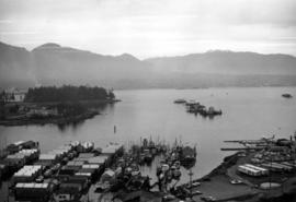
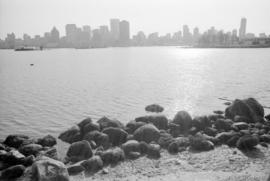
Vancouver skyline and waterfront from Stanley Park seawall
Part of City of Vancouver fonds
Item part is a photograph of the downtown Vancouver skyline and waterfront, looking south across Coal Harbour from the seawall path in Stanley Park. Boat storage units are visible along the coast.

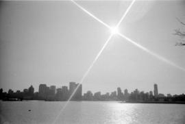
Vancouver skyline from Stanley Park seawall
Part of City of Vancouver fonds
Item part is a photograph of the downtown Vancouver skyline and waterfront, looking south across Coal Harbour from the seawall path in Stanley Park.

Vancouver skyline, Coal Harbour, and Stanley Park seawall beach
Part of City of Vancouver fonds
Vancouver skyline, Coal Harbour, and Stanley Park seawall beach
Part of City of Vancouver fonds
Vancouver skyline and Coal Harbour
Part of City of Vancouver fonds

Staff of Pure Milk Dairy Co. Samuel Garvin Prop. Vancouver B.C. 15/6/16
Part of Major Matthews collection
Photograph shows S. Garvin and others in an automobile among horse-drawn milk wagons and delivery men in front of a bandstand in Robson Park. The photograph also shows houses and buildings in the 500 block 13th Ave E. and the 2900 block Carolina Street.
![[10th Avenue and Cambie Street, site of City Hall]](/uploads/r/null/6/4/6418f3fc5601a83ba3ed95785e1b2578594011e277644210623a99b5dc54714c/5c2e9b9f-71b2-4409-b81f-3d7e89f81135-A09176_142.jpg)
[10th Avenue and Cambie Street, site of City Hall]
Part of Major Matthews collection
Photograph shows the location of the current City Hall prior to construction.
![[Aerial view of Vancouver Harbour from Stanley Park looking east to Indian Arm]](/uploads/r/null/c/b/cb066fdc626d69001bfb4c896937f586737298cc09ee0de3cc7fdd0bca8df09e/93414b9d-edd5-4e76-a79d-fb7a26360472-A31831_142.jpg)
[Aerial view of Vancouver Harbour from Stanley Park looking east to Indian Arm]
Part of Major Matthews collection
Oblique view
Part of Arthur Collier fonds
Item is a photograph of woman [Florence Collier?] on rock by pool.

Part of Elizabeth Walker fonds

The city of Vancouver, British Columbia
Part of City of Vancouver Archives technical and cartographic drawing collection
Item is a map showing postal block numbers, streets, railroads, schools, steamship routes, beaches and hospitals in the city of Vancouver. The map has been annotated to show city parks.

City of Vancouver, British Columbia : co-ordinate street index map 12
Part of City of Vancouver Archives technical and cartographic drawing collection
Map is City Engineering Department base map 149 of the City of Vancouver, showing city blocks, streets and railway lines, as well as the area code co-ordinates assigned by the department. Golf courses, hospitals, schools, theatres and other structures are also identified.

Sheet 1: Slocan Street to Boundary Road and Triumph Street to Burrard Inlet
Part of City of Vancouver Archives technical and cartographic drawing collection
Item is a section showing the area bound by Slocan Street, Boundary Road, Triumph Street and the waterfront. Includes streets, roads, railways, blocks, lots, legal descriptions, quit claims, leases, parks and businesses along the waterfront.
Vancouver (B.C.). Office of the City Engineer

Sheet 2: Slocan Street to Boundary Road and Charles Street to Triumph Street
Part of City of Vancouver Archives technical and cartographic drawing collection
Sheet is a section showing the area from Slocan Street to Boundary Road and Charles Street to Triumph Street. Includes streets, roads, blocks, lots, legal descriptions, parks, schools, and retirement homes.
Vancouver (B.C.). Office of the City Engineer

Sheet 3 : Slocan Street to Boundary Road and Seventh Avenue to Charles Street
Part of City of Vancouver Archives technical and cartographic drawing collection
Item is a section showing the area from Slocan Street to Boundary Road and Seventh Avenue to Charles Street. Includes streets and roads, blocks, lots, legal descriptions, parks and schools.
Vancouver (B.C.). Office of the City Engineer

Sheet 10 : Clark Drive to Slocan Street and waterfront to Triumph Street
Part of City of Vancouver Archives technical and cartographic drawing collection
Item is a section showing the area from Clark Drive to Slocan Street and waterfront to Triumph Street. Includes streets and roads, blocks, lots, legal descriptions, railways, parks, boys' detention home and businesses along the waterfront. The Town of Hastings is indicated on the map.
Vancouver (B.C.). Office of the City Engineer

Sheet 19 : Maple Street to Richards Street and Drake Street to Third Avenue
Part of City of Vancouver Archives technical and cartographic drawing collection
Item is a section showing Maple Street to Richards Street and Drake Street to Third Avenue. Includes streets, roads, blocks, lots, legal descriptions, parks, schools, the Burrard and Granville Street Bridges, C.P.R. right-of-ways, the Squamish Band reserve, C.P.R. leases and property, and government reserve. Map includes Granville Island.
Vancouver (B.C.). Office of the City Engineer

Sheet 16 : St. George Street to Argyle Street and Fifty-eighth Avenue to Fraser River
Part of City of Vancouver Archives technical and cartographic drawing collection
Item is a section showing the area from St. George Street to Argyle Street and Fifty-eighth Avenue to the Fraser River. Includes streets, roads, blocks, lots, legal descriptions, railway lines, parks and schools.
Vancouver (B.C.). Office of the City Engineer

Sheet A : University Endowment Lands to Imperial Street and waterfront to Fifth Avenue
Part of City of Vancouver Archives technical and cartographic drawing collection
Item is a section showing the area from the University Endowment Lands to Imperial Street and waterfront to Fifth Avenue. Includes streets, roads and sewers; blocks, lots and legal descriptions; and parks.
Vancouver (B.C.). Office of the City Engineer

Sheet G : Trafalgar Street to Granville Street and Sixteenth Avenue to Nanton Avenue
Part of City of Vancouver Archives technical and cartographic drawing collection
Item is a section showing the area from Trafalgar Street to Granville Street and Sixteenth Avenue to Nanton Avenue. Includes streets, roads and sewers; blocks, lots and legal descriptions; and parks, railway lines and schools.
Vancouver (B.C.). Office of the City Engineer