
- AM1519-: PAM 1932-67-: LEG1319.327
- Part
- 1932
239 results with digital objects Show results with digital objects


Sectional map and street directory of Vancouver, British Columbia : cover page

Sectional map and street directory of Vancouver, British Columbia : title page


Westmount Park : the subdivision superb : side 2
Part contains information about purchasing lots in Westmount Park and is accompanied by two inset maps. One map shows the lots for sale from Blanca Street to Belmont Drive to Tolmie Street to Second Avenue, their numbers and a price list, the other map shows where Westmount Park is situated in Vancouver.

Part shows a map of the City of Vancouver extending from Boundary Road to Burrard Inlet to Alma Street to King Edward. Lot numbers and street names are shown, along with ward lines, district lot lines street railway lines and railroad lines represented by a legend in the bottom left corner.

Standard tourist's guide to Stanley Park : page 1
Part contains historical information and general information about visiting Stanley Park.

Standard tourist's guide to Stanley Park : Stanley Park, Vancouver, B.C., key plan
Part is a map showing points of interest in Stanley Park, including car lines, roads and car routes, buildings, beaches, and trails.

How to see Vancouver, Canada : side 1
Part is one side of pamphlet entitled "How to see Vancouver, Canada." Part contains suggestions for activities, trips and locations to visit, as well as two inset maps: "Street Map of Vancouver's Business District" and "Roads in Vancouver and District."

Vancouver Centennial 1886-1986
Item is a poster featuring a painting by Hugh Ricks of an otter.
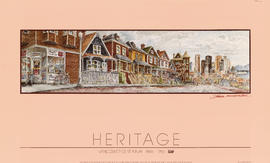
Heritage : Vancouver Centennial 1886-1986
Item is a poster featuring a painting by Michael Kluckner of a Vancouver streetscape filled with heritage houses.

Christmas card re: 1954 British Empire Games held in Vancouver
Item is a Christmas card with a greetings message inside and a note on the British Empire and Commonwealth Games and a photograph showing the Empire Stadium.
![Vancouver, British Columbia [Symphony of Fire poster]](/uploads/r/null/b/2/f/b2fc8e1101e775b82df877771053810d8a74a02217b9da40535e736ec9a03a08/b58b1fdf-98ce-4a60-b816-5ca8bd8ca07e-2009-013_142.jpg)
Vancouver, British Columbia [Symphony of Fire poster]
Item is a poster advertising the Symphony of Fire fireworks event in Vancouver. The poster features a photograph of the Burrard Bridge with fireworks in the background, by Doug Shanks.
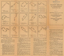
Transit routes in downtown Vancouver : side 1
Part contains illustrations of the downtown Vancouver portions of the B.C. Electric transit routes and text descriptions of all B.C. Electric transit routes in Vancouver, New Westminster, North Vancouver, Richmond, and Burnaby effective up to and including February 15, 1950.

Transit routes in downtown Vancouver : side 2
Part contains a continuation of text descriptions of transit routes from side 1. Part also contains a map showing B.C. Electric transit routing in downtown Vancouver. Map includes street names and a legend of routes and stops.

Shortest - fastest : fair to fair : United Air Lines : side 1
Part contains text about United Air Lines service including reservation and schedule information.
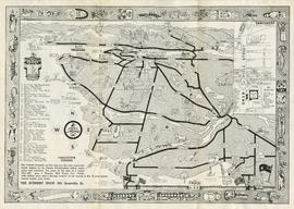
Scenery Shop pamphlet : side 2
Part contains a map showing Vancouver, Surrey, Coquitlam, Burnaby, North Vancouver, Sea Island and Lulu Island illustrated with people, animals, vehicles and buildings. The map shows few street names, tourist destinations, and the location of the Scenery Shop in an inset map. A border with First Nations symbols surrounds the map and is accompanied by a legend of symbols.
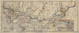
Part contains a map showing picnic sites across the Lower Mainland. Map extends from Straight of Georgia to Alice Lake to Cascade Mountains to Limestone, Washington. Map includes two inset enlargement maps of Horseshoe Bay and Squamish, and of Stanley Park to Spanish Banks.

Sectional map and street directory of Vancouver, British Columbia : street directory

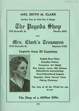
Sectional map and street directory of Vancouver, British Columbia : Eddie R. Deem advertisement

Sectional map and street directory of Vancouver, British Columbia : Castle Hotel advertisement

Sectional map and street directory of Vancouver, British Columbia : index to maps

Sectional map and street directory of Vancouver, British Columbia : street directory

Sectional map and street directory of Vancouver, British Columbia : street directory

Sectional map and street directory of Vancouver, British Columbia : street directory

Sectional map and street directory of Vancouver, British Columbia : Blue Ribbon advertisement

Sectional map and street directory of Vancouver : index to maps

Sectional map and street directory of Vancouver : street directory

Sectional map and street directory of Vancouver : street directory


Boat trip up Indian Arm : Indian River Pk, Wigwam Inn : side 2
Part contains information about the boat trip to Wigwam Inn and is illustrated with photographs showing scenery, the interior and exterior of the inn, and views from the boat route.

Sylvia Court : Gilford at Beach, Vancouver, B. C. : side 2
Part contains text advertising Sylvia Court accompanied by photos of the hotel interior, and English Bay.

Wigwam Inn : hunting, fishing, boating and mountaineering : side 2
Part contains information about prices, boat schedules, activities and attractions of the Wigwam Inn, as well as photographs showing the inn, and local viewpoints.

Welcome to Vancouver Canada : side 1
Part contains advertisements, tourist information, trip recommendations and is illustrated with photographs of popular Vancouver destinations.
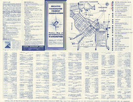
Visitors' map of metropolitan Vancouver : side 1
Part contains one inset map of Downtown Vancouver showing 26 points of interest and street names. Part also contains text with tourist information including traffic rules, and a list of businesses and services.
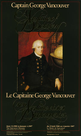
Poster for exhibition at Vancouver Museum, June 13, 1986 to January 4, 1987 on Captain George Vancouver, in celebration of Vancouver Centennial

Sectional map and street directory of Vancouver, British Columbia : Iris Steam Baths advertisement

Sectional map and street directory of Vancouver, British Columbia : introduction to map

Sectional map and street directory of Vancouver, British Columbia : street directory

Sectional map and street directory of Vancouver, British Columbia : street directory

Sectional map and street directory of Vancouver, British Columbia : street directory