Add to clipboard
Tidal current chart, Vancouver Harbour : one hour before maximum flood at First Narrows
Add to clipboard
Tidal current chart, Vancouver Harbour : one hour after maximum flood at First Narrows
Add to clipboard
Tidal current chart, Vancouver Harbour : two hours after maximum flood at First Narrows
Add to clipboard
Tidal current chart, Vancouver Harbour : inside back cover
Add to clipboard
Champlain Heights : D.L. 334, group one, N.W.D.
Add to clipboard
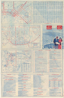
Greater Vancouver road map : map cover
Add to clipboard
Bus routes, city of Vancouver, November 26th 1937
Add to clipboard
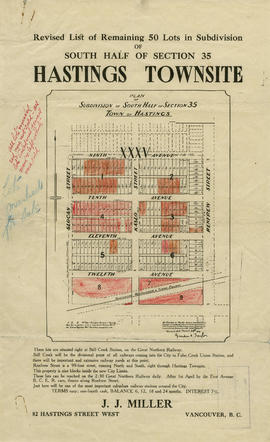
Revised list of remaining 50 lots in subdivision of south half of section 35, Hastings Townsite
Add to clipboard
Insurance plan of Port Coquitlam : key plan and sheet 1
Add to clipboard
Insurance Plan of Port Coquitlam : sheet 4
Add to clipboard
Information concerning the City and District of New Westminster and the Province of British Columbia
Add to clipboard
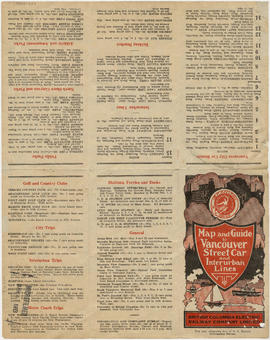
Map and guide to Vancouver street car and interurban lines
Add to clipboard
Vancouver city and suburban lines
Add to clipboard
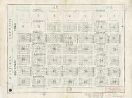
Hastings Townsite [Boundary Road to 5th Avenue to Kamloops Street (?) to 33rd Avenue]
Add to clipboard
Map and guide to Vancouver street car and interurban lines
Add to clipboard
Map of Lulu Island and Sea Island ; Municipality of Surrey ; Map of Maillardville ; University Endowment Lands
Add to clipboard
Map of downtown section of Vancouver ; Diagram of New Westminster, B.C., downtown section
Add to clipboard
Automobile road map of Greater Vancouver and environs : map cover
Add to clipboard
Through the Canadian Pacific Rockies : a large scale map of the mountains from Calgary to Sicamous : map cover
Add to clipboard
Through the Canadian Pacific Rockies : a large scale map of the mountains from Calgary to Sicamous : inside map cover
Add to clipboard
Vancouver, B.C., the Pacific coast terminus of the C.P.R. [Canadian Pacific Railway]
Add to clipboard
Hastings Townsite : Renfrew Street to Rupert Street and 5th Avenue to 13th Avenue
Add to clipboard
Hastings Townsite : Rupert Street to Boundary Road and 5th Avenue to 13th Avenue
Add to clipboard
Hastings Townsite : Nanaimo Street to Renfrew Street and 13th Avenue to Strathcona Road (22nd Avenue)
Add to clipboard
Hastings Townsite : Renfrew Street to Rupert Street and Strathcona Road (22nd Avenue) to Government Road (29th Avenue)
Add to clipboard
Top left plate
Add to clipboard
Top left plate
Add to clipboard
Howe Sound - Burrard Inlet [Howe Sound portion]
Add to clipboard
Howe Sound - Burrard Inlet [Burrard Inlet portion]
Add to clipboard
Vest pocket map of Vancouver : map A
Add to clipboard
Indexed guide map of the city of Vancouver and suburbs
Add to clipboard
Indexed guide map of the city of Vancouver and suburbs : map booklet front cover
Add to clipboard
Hotels
Add to clipboard
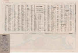
Street index (Royal Oak Avenue, Vancouver to Frederick Road, North Vancouver)
Add to clipboard
A few facts about the north Fraser River
Add to clipboard
Front page and index map
Add to clipboard
Street index
Add to clipboard
B.C. Electric guide to Greater Vancouver
Add to clipboard
Vancouver, British Columbia, Canada
Add to clipboard
Map and information concerning the City and District of New Westminster and Province of British Columbia
Add to clipboard
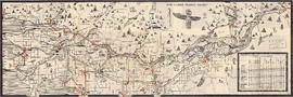
The lower Fraser Valley
Add to clipboard
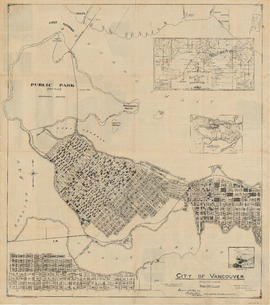
City of Vancouver : Canadian Pacific town site
Add to clipboard
Vancouver, B.C., Pacific terminus of the C.P.R.
Add to clipboard
City of Vancouver. Canadian Pacific town site
Add to clipboard
District Lot 69
Add to clipboard
192 : plan of Provincial Government property being a portion of Townsite of Vancouver and subdivision of Lot 540 Group 1, New Westminster District, B.C., to be sold by public auction
Add to clipboard
Street index
Add to clipboard
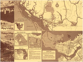
Neighbourhood maps and British Columbia map
Add to clipboard
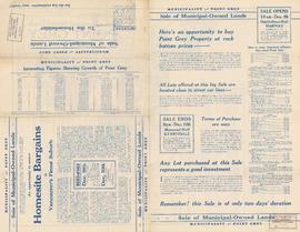
Municipality of Point Grey : sale of municipal-owned lands
Add to clipboard
City of Vancouver. Canadian Pacific town site


![Hastings Townsite [Boundary Road to 5th Avenue to Kamloops Street (?) to 33rd Avenue]](/uploads/r/null/7/f/0/7f0fe2a27b9af4f20ad7837792af3bbb3aa93c3487024e69b14fa38144134f19/8e7a0e66-c6cc-40ca-bbac-4ea73db77437-LEG1800_142.jpg)


![Vancouver, B.C., the Pacific coast terminus of the C.P.R. [Canadian Pacific Railway]](/uploads/r/null/8/3/f/83fcf65f0d66d64e6357d0d647e0ea6e2fa4aae4c3d1919f952d7725b4299cda/623e750c-fbab-43b7-a496-d20b384baeb6-LEG1321_142.jpg)


![Howe Sound - Burrard Inlet [Howe Sound portion]](/uploads/r/null/7/a/1/7a1896077ddc37a7e16ac2d7e42a66031e13e11a9d966c43fca06cbb56f8bd96/5edd8d92-d3cd-4663-8fdd-996b3ae7a402-MAP30a_142.jpg)
![Howe Sound - Burrard Inlet [Burrard Inlet portion]](/uploads/r/null/f/8/5/f8523992bb5d5e0c1391f2dea183041a54a2d2470eb4047bb29958a0d835ae95/fdf9563d-923e-468a-a494-3ff190294b91-MAP30b_142.jpg)