![[Clearing the road after the Seymour Creek washout]](/uploads/r/null/f/c/fc6cfe672265e867d583e925ffa6c0fd3a92c7305bcba121a6f71a099afd83a8/56561df4-6b84-4fc0-b5c1-6523edbfeb84-A33580_142.jpg)
[Clearing the road after the Seymour Creek washout]
- AM54-S4-: Out P719.20
- Item
- Oct. 1921
Part of Major Matthews collection
703 results with digital objects Show results with digital objects
[Clearing the road after the Seymour Creek washout]
Part of Major Matthews collection
![[Construction of reservoir at Burwell Lake]](/uploads/r/null/0/9/09c494c0b883a3802afc29a5e0bfc8fad1ac3d712e98b1752cd982e0e7fbba5a/e7e4cb28-28df-4157-8e36-7b99bd5469da-A09314_142.jpg)
[Construction of reservoir at Burwell Lake]
Part of Major Matthews collection
![[Construction of reservoir at Burwell Lake]](/uploads/r/null/4/1/41b1e914a992698a666e1d324c08055e61e7e87450fe7023e1739d2104827b24/83bb7367-b7ef-4bbb-85d2-82a6f3fd608e-A09315_142.jpg)
[Construction of reservoir at Burwell Lake]
Part of Major Matthews collection
![[Construction of reservoir at Burwell Lake]](/uploads/r/null/7/7/7786039fc4e1c663927bd33feba77389488d28e353a4030d15f3eea0e1a4b468/f296699c-b70d-4760-8bb2-ca669d9a76fc-A09319_142.jpg)
[Construction of reservoir at Burwell Lake]
Part of Major Matthews collection
![[Construction of reservoir at Burwell Lake]](/uploads/r/null/5/d/5d3eb3f1bd505c6d220057e12b921c693540398850bda204a6a8d104d3246071/6901d2e1-572e-44dd-bc4d-126bb3859d8a-A09321_142.jpg)
[Construction of reservoir at Burwell Lake]
Part of Major Matthews collection
![[Ferry line-up on Lonsdale Ave.]](/uploads/r/null/5/c/5c8eff95868920550dde6725bdf16b8ff7e523a1e2c2089aa09d9326bf74e691/0f1bd0ab-7225-4f8c-8bb4-78309ac87686-A24500_142.jpg)
[Ferry line-up on Lonsdale Ave.]
Part of Major Matthews collection
![[Ferry line-up on Lonsdale Avenue up to Eighth Street]](/uploads/r/null/0/7/07c1d194551657a593def712e867cd96259b6e82559677fc17d0b3c0ceceb28d/88726415-08cd-4424-9062-15ff90ff2cdf-A24499_142.jpg)
[Ferry line-up on Lonsdale Avenue up to Eighth Street]
Part of Major Matthews collection
![[Fifteenth Street looking east towards Grand Boulevard]](/uploads/r/null/7/3/73a89135f77f03c2170bc52234ba67e4d5b33dd68391be03e9ca3753fb8abd65/1332756e-55c4-4d2a-93f8-9e02d7c4bc28-A33961_142.jpg)
[Fifteenth Street looking east towards Grand Boulevard]
Part of Major Matthews collection
![[Fred Hicklenton, W.J. McGuigan, James McGeer and unidentified boy on Grouse Mountain]](/uploads/r/null/2/8/28b588272bf0ab82578cc05f6162c654be9eac77e4c2b9c56b6816393d40ab02/0be94fa6-3b6f-4560-8bd7-a041b3d8ac32-A32831_142.jpg)
[Fred Hicklenton, W.J. McGuigan, James McGeer and unidentified boy on Grouse Mountain]
Part of Major Matthews collection
![[Water system at Burwell Lake]](/uploads/r/null/2/7/9/279dc4809a615465d8340864db760b573ee6165405b7f7f455028d1604266087/71276c87-a294-4c13-9d87-8a3023d1e0fe-PANP66_142.jpg)
[Water system at Burwell Lake]
Part of Major Matthews collection
Item is a panorama print created from negatives Mount N38.1 (left side) and Mount N38.2 (right side).

Part of Major Matthews collection
The map is a draft of MAP 56.01, "Indian villages and landmarks, Burrard Inlet and English Bay, before the whiteman came." It shows the geographic area bounded by the north shore of Burrard Inlet, the Freaser River, Point Atkinson, and the Burrard Inlet Second Narrows. Shown on the map are locations of First Nations and European settlements, streams, coastal features, and inland vegitation. Physical features are labeled using both First Nations and European place names.

Draft map of Indian villages and landmarks, Burrard Inlet and English Bay, before the whiteman came
Part of Major Matthews collection
The map is a draft of map 56.01, "Indian villages and landmarks, Burrard Inlet and English Bay, before the whiteman came." It shows the geographic area bounded by the north shore of Burrard Inlet, the Fraser River, Point Atkinson, and the Burrard Inlet Second Narrows. Shown on the map are coastal sites labeled with First Nations place names.
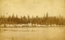
![[The Mission at St. Paul's Church]](/uploads/r/null/3/e/3ed9ffdde571c4d81bfe19b0a46fe683b58b8abef28a5c5deb2bb773ed990371/69dba689-d44e-4d3f-8b58-2528d00ecdcf-A26402_142.jpg)
[The Mission at St. Paul's Church]
Part of Major Matthews collection
![[The ruins after the fire at Wallace Shipyards]](/uploads/r/null/3/5/3510614afecfbf0d0efa59274f61d732b6c378b911d78fcb13fcb379e225f756/b2b61dad-0317-420a-b5ee-200cadd7203c-A43394_142.jpg)
[The ruins after the fire at Wallace Shipyards]
Part of Major Matthews collection
![[Two men and two women posing with bull at Barrow property near Lynn Creek]](/uploads/r/null/0/e/0e6fae5ca38437fd898349f11fb54fb751649b827d0f9a99a83cc7318b91b418/6a714ba0-68de-400b-8d47-6e9bfdd57fbf-A07823_142.jpg)
[Two men and two women posing with bull at Barrow property near Lynn Creek]
Part of Major Matthews collection
![[Two men in front of shack on Grouse Mountain]](/uploads/r/null/a/1/a11ff513fbfe57041e6bb560bb4ea1cbfb2a64135d7e738ccc0358f3fad92c3f/7576638f-d390-4172-8ec9-cc3f7333e328-A32824_142.jpg)
[Two men in front of shack on Grouse Mountain]
Part of Major Matthews collection
![[Man spearing salmon in Seymour Creek]](/uploads/r/null/8/7/87148857ce94646d1531f9ee8957aad670b22e3eb8951b4d71247bc0c327733a/31213c49-ad70-4a56-af4f-c2a107c5c701-A04199_142.jpg)
[Man spearing salmon in Seymour Creek]
Part of Major Matthews collection
J.S. Matthews' notes with print or negative in Archives.
![[Members of the North Vancouver Yacht Club]](/uploads/r/null/1/d/1dbb1d0894627bfb3b150c3811cfe54b7ba95a356acd0e997a81ab3be1cdd617/579107b9-56f4-433c-85f3-1939df87cabb-A35977_142.jpg)
[Members of the North Vancouver Yacht Club]
Part of Major Matthews collection
Group portrait showing (left to right) back row: Mr. Heaven, Henry Woods, unknown, John A. MacMillan and Mr. Dyke; front row: unknown, J.B. Paine, J.J. Woods, Elsworth MacMillan and unknown
![[Men in front of the Capilano Water works Intake building]](/uploads/r/null/1/4/142821200c53cab6dd0555b64f71cdf59da4523247e54a10ed382565eed5b932/c3686577-607b-478a-ad7c-a31821ab181a-A25795_142.jpg)
[Men in front of the Capilano Water works Intake building]
Part of Major Matthews collection
Men identified (left to right): Dr. F.T. Underhill, Frank S. DeGray, F.L. Fellowes, E.M. LeFlufy and James Kendrick
![[Seymour Creek after the washout]](/uploads/r/null/c/e/cec640095e3f626bd4ca0a07e24513e8d27413cdd3b3ab9dd642cf32604d7725/72918b52-7fb0-4267-b616-fef807a95b77-A33582_142.jpg)
[Seymour Creek after the washout]
Part of Major Matthews collection
![[Seymour Creek after the washout]](/uploads/r/null/8/e/8e0e093a75f51025d912d6b6b90c18a8408042f6a23f21af30c3cece929130e1/86a7d2b4-3fc7-43c6-8b15-b2e24ef4a55b-A33583_142.jpg)
[Seymour Creek after the washout]
Part of Major Matthews collection
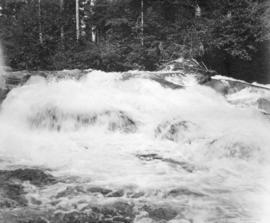
![[Seymour Creek washout]](/uploads/r/null/9/2/92839d9c1bce27b0af4fbbd72f530609f1ac25d487ef75c590ddc244eaa3b6da/4480af90-bde8-4346-bce9-eaf2f8f35aa0-A33567_142.jpg)
Part of Major Matthews collection
![[Shack on Grouse Mountain]](/uploads/r/null/9/e/9ea7c551fb5efa00d31bdd611f68296ec36e312c4c3e03ed740464b03f398d39/edf61a80-de65-44a1-9361-edce2ea63d1e-A32826_142.jpg)
Part of Major Matthews collection
![[Shingle bolt flume in Capilano Canyon]](/uploads/r/null/f/2/f2124db4fa59457e9c4eefd5cda86dcf04a79c712338fb3ed1988a2d0e7dc839/2443f23a-3759-4fd0-8f84-b59cc062a3b8-A33465_142.jpg)
[Shingle bolt flume in Capilano Canyon]
Part of Major Matthews collection

Part of Major Matthews collection

Part of Major Matthews collection
Man addressing crowd identified as Reeve McNaught.
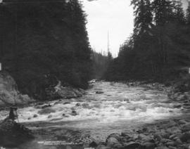
![[Looking into Capilano Canyon]](/uploads/r/null/6/3/63e8a30922fb08f77d37f3ad1095da4323ebafe47140d8429fa05466feb9856e/1173f07e-b408-49d0-bc54-b1fd1651a784-A33039_142.jpg)
[Looking into Capilano Canyon]
Part of Major Matthews collection
Photograph shows an old shingle bolt flume
![[Major J.S. Matthews unveils wooden memorial for Moodyville at the foot of Queensbury Avenue]](/uploads/r/null/0/e/0e1a710fbe6a94abe6ea8bca9ddf254c482cae84d918a74b54f392f454bd341c/7bc7a125-f3e2-4c3e-b168-f66397243cca-A32764_142.jpg)
[Major J.S. Matthews unveils wooden memorial for Moodyville at the foot of Queensbury Avenue]
Part of Major Matthews collection
Photograph shows Mrs. Carrie M. Cates, Captain B.D.L. Johnson, and Frank Goldsworthy
![[Man and woman on] suspension bridge, Capilano](/uploads/r/null/2/4/240feb74b8afb0a96593537289121d9a8cf27a307614c45aecd6a593aa576145/f368f557-bec8-4f04-bf1e-b341fc7b0625-A04425_142.jpg)
[Man and woman on] suspension bridge, Capilano
Part of Major Matthews collection
J.S. Matthews' notes with print or negative in Archives.

Putting the 45 ton boilers into S.S. "War Dog" Wallace Shipyards, North-Vancouver, B.C.
Part of Major Matthews collection

Part of Major Matthews collection
Part of Major Matthews collection

Seymour Creek water system. Plan of intake
Part of Major Matthews collection
Photograph negative is a copy of a technical drawing of a cross section of a water intake system.
Part of Major Matthews collection

A Fallen Giant (Diameter 13 feet) Lynn Valley, B.C.
Part of Major Matthews collection

Part of Major Matthews collection
Photograph shows A.W. Ross, Dr. McGuigan, Mr. Jackson, W.E. Gravely and others and the Phibbs and Thompsons Milk Ranch House

Canyon View Hotel, Capilano, North Vancouver, B.C.
Part of Major Matthews collection
Part of Major Matthews collection

Part of Major Matthews collection
![Capilano waterworks System [laying pipes]](/uploads/r/null/9/4/949ccf2e51ae1fab90340f9da83a795027039aa833089600e953fd3df75652f5/a45bf37a-f81c-4847-9e68-1c73f3f21ce8-A25757_142.jpg)
Capilano waterworks System [laying pipes]
Part of Major Matthews collection
![Capilano Waterworks System [laying pipes]](/uploads/r/null/e/0/e09bcb9816e84525696fe9d1125b212b3d1f6ef0cff08c8e5460411aa12c6532/64e0a45f-d44d-49c5-90ab-8d22108dd1d2-A25758_142.jpg)
Capilano Waterworks System [laying pipes]
Part of Major Matthews collection

Part of Major Matthews collection
Part of Major Matthews collection
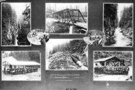
Photograph shows eight images of Seymour Creek canyon and bridge, pipes under construction, and guests at the opening and luncheon

City waterworks dam, Vancouver, B.C.
Part of Major Matthews collection

Councillors District of North Vancouver being sworn in by Judge R.A. Sargent
Part of Major Matthews collection
Photograph shows Councillor G.W. Sargent, Councillor A.D. Poole, Councillor F.M. Reid, Councillor C.E. Scanlan, Councillor William Griffin and Councillor D.G. Currie
![[View of the first Capilano Creek dam under construction]](/uploads/r/null/b/e/bedbcf103b548bda85cf6901c9c4c1beea66a92ec3a205711b581ffc2f355de8/1005a023-9a5f-47be-8507-6cbe186c37a4-A25790_142.jpg)
[View of the first Capilano Creek dam under construction]
Part of Major Matthews collection
![[View of the lake bed prior to the opening of the Cleveland Dam]](/uploads/r/null/8/1/819128c707f9d8acf3c9abf8b4c28f4aada0d6b269cc7260d86ce4cbceac6043/e6b9fb65-b580-4308-a4d9-dc9d9d26a1c3-A33595_142.jpg)
[View of the lake bed prior to the opening of the Cleveland Dam]
Part of Major Matthews collection
![[Water system at Burwell Lake]](/uploads/r/null/a/2/a263f0649897b6ff16ebb080890f9330c6c9daff2421599741ba0876277e808d/b1842f99-ae5b-4fff-afd0-f4bf3fbb15c4-A09275_142.jpg)
[Water system at Burwell Lake]
Part of Major Matthews collection
![[Woman standing in Capilano Canyon]](/uploads/r/null/8/3/83888e8dcf5d0e7d0b79af40e81b56fa72ebb432f30066d5fc6fb79a9135747b/498cf40e-a980-4b00-8938-0eef79c9f1a5-A33040_142.jpg)
[Woman standing in Capilano Canyon]
Part of Major Matthews collection
![[Wood fence to prevent erosion near the Capilano intake]](/uploads/r/null/d/d/dd6e0e2183da6168d0bf1552b3400603b66baefdd283c7870642250b0969079d/f6ef2c63-6f1d-4e43-82cf-294d26bfd1b9-A25751_142.jpg)
[Wood fence to prevent erosion near the Capilano intake]
Part of Major Matthews collection