![Burrard Viaduct Construction [2 of 10]](/uploads/r/null/5/7/57426101abc66a2ab407c951565e28bb07f8f27238a35bb05d7478ded4e540b1/8b87415b-c4bc-4c5c-bf5c-89e3546722c2-A66653_142.jpg)
Burrard Viaduct Construction [2 of 10]
- COV-S663-: CVA 800-2442
- Item
- Sept. 1983
Part of City of Vancouver fonds
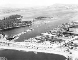
Building of Burrard Viaduct with Coal Harbour in the background, including part of Deadman's Island and a floating fuel station on the left and the mountains beyond.
![Burrard Viaduct Construction [1 of 10]](/uploads/r/null/2/7/2788a9638050d7cbfc021e29977d956f423fe6048bb7c29c035ea57bda6dd66c/5df17b4f-3ebf-4f8d-ac21-de11bd89033f-A66652_142.jpg)
![[English Bay after heavy snowfall]](/uploads/r/null/9/8/98d57e6aa43d81b764d660589019a9777086ef8ffa1ac5d9463a527dee1dbf26/46e3a80b-3931-459d-9c09-b1bd42694079-A16571_142.jpg)
![[Coal Harbour?]](/uploads/r/null/1/0/10b1e3b62444e17b20e5c87b9cb37773568bcad1eb9f6ef2efd8c228b7f06408/5aa04f62-7a7b-4a73-a8bf-7920b9573446-A16631_142.jpg)
![[Coal Harbour?]](/uploads/r/null/f/b/fb269570031b2a3828f329c97b9db78a5236f47cf4286fb78bf3c2058c53b0de/626b353c-ab4a-4c40-bcaf-41aaec70fe04-A16630_142.jpg)
![[Coal Harbour?]](/uploads/r/null/1/c/1c43ca1c74017572cccbbeb20b07dae64a1d3dc2d6ed6573e3555df279535121/dee93f4d-4cde-4f0b-b504-dfb863bfa77d-A16629_142.jpg)
![[Coal Harbour?]](/uploads/r/null/d/b/db2de6c93437b31527635deddfa2d1b0228f1dfd0d78c0bf6d754fd685fc663b/dccf9129-e23d-46e6-8e3f-0adde1d833b8-A16628_142.jpg)
![[Coal Harbour?]](/uploads/r/null/b/4/b488b986b859b20d49e5b4d6f59cb320223b0da4668774c67790e46f15e737a7/ea0b239a-5c45-449d-80f0-04a4483b3cd5-A16627_142.jpg)
![[Coal Harbour]](/uploads/r/null/8/3/83bd003a993aaa90a0c6aea33d3521bf9163833f067d66579783658045125695/447583bd-7a62-4edd-9558-f0bcaf009c90-A16626_142.jpg)
![[Coal Harbour]](/uploads/r/null/e/6/e641a81bbc0d7d8adfb51e6e32ecb57659f5dccdce517fb88dd14160144e3e52/c67b13d2-e877-4fb3-8b2f-0de875c9280a-A16625_142.jpg)
![[Coal Harbour view from Denman Street]](/uploads/r/null/f/4/f4ee6b5b8d147b8a774a97a7b59f6f8c29bb8792a52da1695f47dce307742555/f90773a4-4b21-478d-bd42-505e1d441b47-A16624_142.jpg)

![[North facing cityscape view of the West End showing the] Sheraton-Landmark](/uploads/r/null/7/d/7db38a96995179fe1118994e0c35380cbd8d1bc5909f43a9cb352ba83ea17b88/9e677767-fb6d-4420-91d8-8152f5d4ede1-A59252_142.jpg)
![[Southwest facing cityscape view of the West End]](/uploads/r/null/4/b/4b50b8139a75294378d4e28c633eb1a7201b7a1ffba30b79f1cf631026c1a7bd/4f7badb7-4d85-4c22-8780-a7311c11a932-A59250_142.jpg)
![[Northwest facing cityscape view of the West End]](/uploads/r/null/8/1/8144b464121d2d606915a295fe4bfea95b903893f4ac909e59d22d27b3a6c7db/c58f4286-e96d-4189-ad75-9885f1b17ff7-A59249_142.jpg)


![[View of] Vancouver [harbour]](/uploads/r/null/5/3/e/53ebf8e635066e530178fc0ae20760af8e63cd463f234fe8147486ff21079622/ccc78739-a015-4e39-89ae-adbd98ea7824-CVA256-01_142.jpg)
![Inner harbour [showing] small boats and Union Steamship's "Camosun"](/uploads/r/null/8/3/8303cd242ec78fef75e71bafde482f07bd2b430499cc36c71ed69464e42db9b8/44299432-4d2b-4077-a737-f3e87866a9e9-A76340_142.jpg)
![[View of Coal Harbour from the causeway]](/uploads/r/null/a/1/a11c5844a676582424273c284cfec188f2dfc6c90cb9dd46a741be593d2a3456/caed5a3c-25db-483c-8ad9-fde5e565c38b-A75614_142.jpg)
![[View across Coal Harbour towrds Downtown]](/uploads/r/null/d/d/ddf2d63627f742e05eab0ed197b3b40bc910fd24a176af8b9a75db9e2dd8133c/db7f74b3-f519-43e2-af80-62d88342cfea-A74506_142.jpg)


![[Coal Harbour and Downtown from the Causeway]](/uploads/r/null/d/f/5/df5783e376ce091eaa747d85bdac39ab081c295ffb29db71e675d1326a870c77/8b685d69-96da-4273-b4c4-226e0f99cfc5-CVA260-1224_142.jpg)
![Pender Harbour showing [S.S.] "Comox"](/uploads/r/null/a/8/a830ad06450de793e74a3abcd7300572c52301769d6143086b9a050810f238d5/0c246306-10a0-4982-853f-19c126520072-A76290_142.jpg)
![[Unidentified harbour]](/uploads/r/null/6/8/e/68eebf2b470b00f76d1035ce8d44fb3511a0a7f9ef2df6d93ae2a142fe43d1da/b3562e2a-137e-405e-b1fb-ef92f25870b8-CVA260-1127_142.jpg)
![[View of Vancouver Harbour]](/uploads/r/null/a/0/a0fce588a79be42430d0804a0fd716a8b7f75659abdc5d0bdda3fb6d0037a9d2/d31e0dfb-2197-47d3-9af5-ddbf27174a75-A76378_142.jpg)

![[View of the harbour, C.P.R. Pier 'D' and railroad yard from the roof of the Post Office]](/uploads/r/null/e/4/e403caef05acedfc9e78203f7cac185e22853ec36a357deb2f1e3cbb517c0f44/0ce56549-03f9-4349-9a5e-267ba26928df-A09879_142.jpg)
![[View of the harbour, C.P.R. Pier 'D' and railroad yard from the roof of the Post Office]](/uploads/r/null/0/0/0017cc41004f72fbc45775cf71b997df93d9562b9877c14a78d5a30c67506a85/99ef2020-d62e-4cd3-b0b2-d2a012ec9e1f-A09878_142.jpg)
![[View of the harbour from Spencer's Department Store]](/uploads/r/null/2/0/202e8d9d731fb703dfc9c1c09d19f811ee159ca535e8b61865f31dadd624551c/2a899800-eecb-49bd-9760-2d8c09ed120c-A09877_142.jpg)
![[Aerial view looking east over Stanley Park, Coal Harbour and Burrard Inlet]](/uploads/r/null/d/0/d02fee694c486ac2accdeefb505d0dae5fcb42789ef16de49322d845e3c04b44/be8c34ce-7c09-4c0e-a395-f083c9134080-A43248_142.jpg)
![[Looking east from the Stanley Park bridge to Coal Harbour]](/uploads/r/null/c/5/c5d5a12a1c9782ab5a8523900877fe279312841636d16b6c49d45f78c661b618/886c6082-bc19-41a2-a743-6880e2727074-A43209_142.jpg)
![[Northwest view of Vancouver from Dunsmuir and Hornby Streets]](/uploads/r/null/8/8/88e94ad7604ed40fb7780d502fd141151ebddd9bddf50fa36b4b55a7abda9b58/e8c12a8c-3224-4083-b222-e4b83a4a6952-A65789_142.jpg)

![[View of] Coal Harbour and Stanley Park from Georgia [Street]](/uploads/r/null/8/c/8c0a3b0f859c1a378c1463bc15fea75d46976a8289b6c84fcabef3840f06a3b3/490e919d-235c-4eb3-8693-3641e4b6285c-A09696_142.jpg)

![Coal Harbour [showing] Deadman's Island and Stanley Park](/uploads/r/null/d/6/d6ce3aeb165a91b522ef077ca8156f7e3a8ab8b628022e341045a857c0742bbc/b376f1e6-bd3a-4ad5-92c6-958dc0d2db65-A09656_142.jpg)
![[Parliament Buildings, Victoria, B.C.]](/uploads/r/null/d/0/d0f3827fcba74f71918e13419e6a10f2abbb53aad9ccd3b6e764a59a8e42e0d6/58091dda-eca1-43d9-83d4-2ad2d2a77bb5-A04350_142.jpg)
![[View of Victoria waterfront, showing post office and boats in inner harbour]](/uploads/r/null/f/5/f551525fa2d75fd073c1705b8b964a3c8ca0158646f41313216ae6dac1b20b42/50c336b1-8bdc-428c-91f1-4b9fdf8fdf0e-A04349_142.jpg)

![[View of Victoria, B.C., from the Parliament Buildings, showing the inner harbour]](/uploads/r/null/8/f/8f5ba1a3dcfb32b47cad5fbbc77aa653e2fe8c099588b8474ff8155d773baa05/ad4e4250-3066-40b2-859d-74097692651a-A07654_142.jpg)
![[View of Victoria, B.C., from the Parliament Buildings]](/uploads/r/null/2/5/25b93cd5368b86d92ffa8dea30a9aae210661abc2c05e903a2c0d24dd47158b2/a4f5e146-cd11-44c9-af08-dffe28bbc8dc-A07653_142.jpg)
![[Dock and boats in Esquimalt harbour]](/uploads/r/null/0/e/0e25442aad79db6eaeeaaa96cb15d95efbbfa07cfa78b61916338d055010bac7/4cdf1f29-4665-4203-b3ee-0bc8988719f3-A07650_142.jpg)