![[72nd Seaforths] somewhere on Shaughnessy Heights](/uploads/r/null/d/5/5/d55eeefc0cbbc3027caf41168de857135ff4e60900c3f6b7d1645d10aeddf083/ef585107-ba80-4f76-9c17-5651d7b957e6-2011-037_142.jpg)
[72nd Seaforths] somewhere on Shaughnessy Heights
- AM1376-: 2011-037.5
- Item
- [ca. 1914]
[72nd Seaforths] somewhere on Shaughnessy Heights

Photograph shows the shops and businesses in the background
![[B.C.E.R. street car lines on Main Street near 19th Avenue]](/uploads/r/null/7/3/e/73e171a49b9d33fd82a7891a3093413ccdb0e0d606228e607ebabb058aa07b0f/07deaa2b-63e9-46a5-8321-0971b42db00c-2011-065_142.jpg)
[B.C.E.R. street car lines on Main Street near 19th Avenue]
Photograph shows Dewar's meat and produce market and S. BlackmanTobacconist
![[B.C.E.R. (B.C. Electric Railway) street car lines on Main Street near 20th Avenue]](/uploads/r/null/4/2/b/42b219e7fb97545ad735386109b4ea7924443c2d4c5549bce971687df5cd65fa/afa7e2e3-192c-4e63-8f77-c07a843450af-2011-065_142.jpg)
[B.C.E.R. (B.C. Electric Railway) street car lines on Main Street near 20th Avenue]
Photograph shows S. Blackman Tobacconist and Bingham's dry goods in the background
![H. Cottrell [standing beside an overturned B.C.E.R. streetcar] at the foot of Main Street south](/uploads/r/null/a/3/a3c24ece56c3900d71b6ce2cf0fa2b425f7421fca55cc442f488c2efa7921152/ba7d45e3-356d-44a9-b69e-44457c86ae96-A37755_142.jpg)
H. Cottrell [standing beside an overturned B.C.E.R. streetcar] at the foot of Main Street south
The sign on the streetcar reads: Eburne Track Main St. South 25th Avenue
![[View of] Dominion Mills, Ltd. South Vancouver, B.C.](/uploads/r/null/3/d/3df103cdd0c70f0cee1a01cdc4efef424d87ee1cc70cc1584551d8e4149d6e11/a0506029-def0-4762-b5d9-caf30483e8ab-CVA1376-25_142.jpg)
[View of] Dominion Mills, Ltd. South Vancouver, B.C.
Photograph shows an oblique aerial view of the mill.

The Eburne Sawmills, Ltd. Marpole, B.C.
![Home Economics Class [during] Parents Day [at South Vancouver] High School](/uploads/r/null/7/f/7fcde73027026ef764eaa1baee5ffaf517ac1532df4aac1aef75625d3efd466d/358a69ff-8a7a-45b4-a4df-320f6d900c05-A71762_142.jpg)
Home Economics Class [during] Parents Day [at South Vancouver] High School
Photograph shows a first year girls' frying lesson and Miss Elizabeth Allan beside blackboard in the background
![Looking south from Knight Road [Street and 15th Avenue in Cedar Cottage]](/uploads/r/null/c/4/c40d25f0ce8d064000ee17882a33987e35d7dd3b1a95c189c9745f99adecc4b6/cca6bd4c-d41c-4105-a346-3e034016f971-A43609_142.jpg)
Looking south from Knight Road [Street and 15th Avenue in Cedar Cottage]
Photograph shows a burnt tree stump and houses in the background
![Ethel in woods opposite house [in Cedar Cottage]](/uploads/r/null/e/8/e8e8a53d1e943e9db3fe8574656123cb505778ff15268e015e3620c004f49a91/0208fd6c-df40-4fcf-86cc-4a0c94873fda-A43618_142.jpg)
Ethel in woods opposite house [in Cedar Cottage]
![Cedar Cottage east of Knight [Road (Street)] and 17th Avenue](/uploads/r/null/b/4/b492fa38996370dd180d169a3a884b5b32d052fb47457a9bb81d59d38817e546/acd0ece6-729f-487b-891e-21009740f639-A43619_142.jpg)
Cedar Cottage east of Knight [Road (Street)] and 17th Avenue
![Mail car at Epworth P.O. [Station]](/uploads/r/null/b/4/b4ea17871b6f37cd7ed14f8e930e36c2176289f627d374f8bbc652be720b7ea9/176eaeb2-f488-48c3-aa6c-88ba9934928a-A43620_142.jpg)
Mail car at Epworth P.O. [Station]
Photograph shows a B.C.E.R. car "Sumas"
![Cedar Cottage southeast of Taylor [Road (Welwyn Street)] and Fleming Road [Street]](/uploads/r/null/f/b/fb92cbcaa99b75a770fc3c4d0af4b0188b96ca055381812b9574044cfe564105/65f53015-ca40-48ec-a329-6f5ea99890f9-A43621_142.jpg)
Cedar Cottage southeast of Taylor [Road (Welwyn Street)] and Fleming Road [Street]
![Epworth Post Office [and store, R. Frost Proprietor]](/uploads/r/null/0/f/0fd774c633c3ee8a070d22d4b7b7ae7e5a7f6cb78fcf454a5251e8a655cce5d8/791da4c7-6cea-4a3b-bb51-e40965100050-A43622_142.jpg)
Epworth Post Office [and store, R. Frost Proprietor]

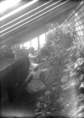
Millie and Elsie in greenhouse
![Flett Road [East 18th Avenue] east of Knight Road [Street in Cedar Cottage]](/uploads/r/null/5/d/5d59076afb046ed723b664f2d976a42d6191b20f58a870480a1b3a104f9b3e62/3962b6fd-a308-416a-9d1d-3dd2d4494166-A43626_142.jpg)
Flett Road [East 18th Avenue] east of Knight Road [Street in Cedar Cottage]
![Corner Knight [Road (Street)] and Flett Road [East 18th Avenue in Cedar Cottage] looking northwest](/uploads/r/null/f/b/fbf1d1096842e1a9c89c102fba537fe32f87f8d0c42318a2d9092eb5604dc6af/c33ea794-6999-4003-8f5e-54a7d4fb34f9-A43627_142.jpg)
Corner Knight [Road (Street)] and Flett Road [East 18th Avenue in Cedar Cottage] looking northwest
![Looking north, our house [in Cedar Cottage]](/uploads/r/null/d/c/dcd996eac0a13402f4d8523881fb8c843a7e540f74defd5934cbc0f7e8aef362/03eb79a9-190d-4494-96af-15b33b1b7a0a-A43610_142.jpg)
Looking north, our house [in Cedar Cottage]
Photograph shows cleared lots and houses in the background

![George [in] Cedar Cottage, east of our house](/uploads/r/null/3/6/369b27c8879e69e8304e1f3994617b767ec53bd74c99288bc16b6ab291189856/9fef47cf-5178-40be-8de5-d0d1df9506d4-A43634_142.jpg)
George [in] Cedar Cottage, east of our house
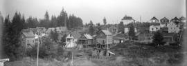
Cedar Cottage, east of our house

Cedar Cottage north of our house

Cedar Cottage east of our house
Photograph shows the houses at 3401 and 3473 Fleming Street near the top right
![[Illustration of "The Passing of the Buffalo"]](/uploads/r/null/b/e/be193c2e4bc82a115b851568b856885b6d75c55a0f8b6aa89867338347441453/210337bb-3b5e-47f5-a05b-d90f1dcfc57c-A43638_142.jpg)
[Illustration of "The Passing of the Buffalo"]
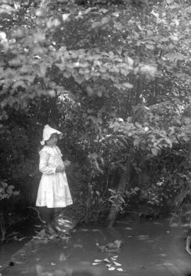
![Elsie [Timms] and playmates by creek, 15th Avenue [in Cedar Cottage]](/uploads/r/null/0/0/00d9d4245952893f2082787b0d811598f330e2ed4162899b1765bcf36b272f07/4b458710-8fad-499b-8612-096ea924a818-A43611_142.jpg)
Elsie [Timms] and playmates by creek, 15th Avenue [in Cedar Cottage]
![George in yard [Knight Road (Street) in Cedar Cottage]](/uploads/r/null/3/7/370a470ec120321606f6a05dadfe87fb123847ae651e3d85a09d533c818fa6cb/f5038105-c39a-40f6-bb5b-626cdb06ebc8-A43612_142.jpg)
George in yard [Knight Road (Street) in Cedar Cottage]
![Buffalo Grocery, 14th Avenue and Park [Commercial] Drive](/uploads/r/null/e/a/eafa4805b5cbde004a8ec53018e86ce8a3f7bc19cb9283c1dbb31e5183be2c21/54a36127-edac-4f96-af43-a99c7d462503-A43613_142.jpg)
Buffalo Grocery, 14th Avenue and Park [Commercial] Drive
![Our house 3286 Knight Road [Street in Cedar Cottage]](/uploads/r/null/b/7/b708ba0cdbcaaaedd4b6b4867f56ee5351058136528b316843a779a6ff0fb2d0/481c3488-7a41-472f-8f60-fcb450f20136-A43614_142.jpg)
Our house 3286 Knight Road [Street in Cedar Cottage]
![Robson Memorial Methodist Church, Fleming [Road (Street)] and Flett Road [East 18th Avenue in Ced...](/uploads/r/null/6/b/6b085ee5e271398674afd6068ac752b7e4e6f1f01b900d27b39cdcc1b24dc446/87e96cf7-3e25-4946-bc96-cb883a074e8a-A43615_142.jpg)
Photograph shows the interior
![Robson Memorial Methodist Church, Fleming [Road (Street)] and Flett Road [East 18th Avenue in Ced...](/uploads/r/null/9/c/9cfacfdd4e1a53e66c270439de11991a0311b4c30d8c0006c1cd87bd5ea32bcf/c0efda79-3dbd-46b3-8b1a-3b35386398cb-A43616_142.jpg)
Photograph shows the interior
![Robson Memorial Methodist Church, Fleming [Road (Street)] and Flett Road [East 18th Avenue in Ced...](/uploads/r/null/f/2/f23cb81ef8063fdccc1a08059056a46bcf3fde2f51aa45321929907117a0cd43/e0f2cfa2-6093-4a62-91c3-366c6df49c19-A43617_142.jpg)
Photograph shows the exterior and a boy and a cat by the front door

Aerial photo, vertical, Little Mountain and Oakridge and surrounding area
Item is a photograph of Little Mountain and Oakridge, showing from W 30th Avenue to W 54th Avenue, and from Hudson Street to Main Street. Includes the Langara golf course and Queen Elizabeth Park.

Cecily R. Hunt with dog in South Vancouver
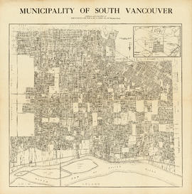
Municipality of South Vancouver
Part of McGuigan family fonds
Item is a map showing legal addresses in South Vancouver. An inset map shows the Municipality of South Vancouver in relation to the rest of the Greater Vancouver area.

Grand Army United Veterans Juvenile Troupe
Part of Stuart Thomson fonds

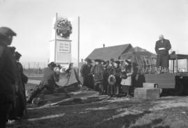
Skaters at Trout Lake, taken for Star Publishing Co.
Part of Stuart Thomson fonds

Skaters at Trout Lake, taken for Star Publishing Co.
Part of Stuart Thomson fonds

Skaters at Trout Lake, taken for Star Publishing Co.
Part of Stuart Thomson fonds
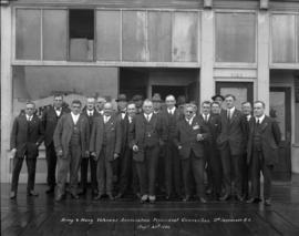
Army and Navy Veterans Association Provincial Convention South Vancouver, B.C.
Part of Stuart Thomson fonds
Group portrait
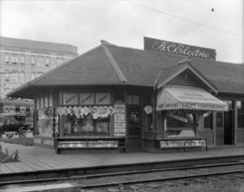
B.C. Electric Railway Company News Stands - New Westminster, Marpole, Granville Street Bridge
Part of Stuart Thomson fonds
Photograph shows a concession stand at the Marpole Station
![South Vancouver Post Office [Postal Station C, 3100 Main Street and 15th Avenue East]](/uploads/r/null/5/6/56703776f8a0097aeeb0d4e5082c268176a822a08ba798fdd07d6902e8848ab7/40d9600d-7250-49a5-a43b-3a75c1efc628-A16234_142.jpg)
South Vancouver Post Office [Postal Station C, 3100 Main Street and 15th Avenue East]
Part of Stuart Thomson fonds
Building is now known as Heritage Hall, 3102 Main Street.
Part of Stuart Thomson fonds

South Vancouver, 49th Avenue East

Part of City of Vancouver Archives technical and cartographic drawing collection

Plan of subdivision of part of D.L. 526 : South Vancouver
Part of City of Vancouver Archives technical and cartographic drawing collection
Item is a map denoting Canadian Pacific land in D.L. 526. The map shows blocks 581-584, 601-604, 621-624, 661-664, 681-684 bounded on the north by 20th Ave., south by McMullen Ave., east by Ontario Street, and west by Bridge Street.

Index plan of provincial government lands to be sold at auction at Vancouver B.C. November 20, 1906
Part of City of Vancouver Archives technical and cartographic drawing collection
Item is a map showing lots owned by the provincial government to be sold at auction. Lots are located in North Vancouver, Vancouver, South Vancouver, Hastings Townsite and Burnaby.

Plan of part of subdivision of district lot 540. South Vancouver
Part of City of Vancouver Archives technical and cartographic drawing collection
Item is a map showing provincially-owned properties for sale in District Lot 540, South Vancouver, B.C.

City of Vancouver : Canadian Pacific town site
Part of City of Vancouver Archives technical and cartographic drawing collection
Part contains four maps. The main map shows district lots and block numbers in Vancouver from Vine Street in the west to Boundary Avenue (Glen Drive) in the east and Stanley Park in the north to 9th Avenue (Broadway) in the south. Three smaller maps include an index plan to district lots in Vancouver, South Vancouver, New Westminster, and Burnaby; a world map showing Canadian Pacific mail steamship lines; and an index plan of Vancouver city limits.