
Northerly portion Vancouver Island
- AM75-F26-: LEG1374.08
- Item
- 1948
Item is a map of northern Vancouver Island and the adjacent British Columbia coast showing Crown and reserve lands, timber leases, district, park, and provincial forest boundaries, cities, municipalities, villages, post offices, hospitals, roads, railways, seaplane ports and anchorages, airports, elevations of some geographical features, and marine distances in nautical miles.


![Dr. Brink describing lupin in meadow on V. I. [Vancouver Island] Long Beach](/uploads/r/null/c/4/0/c401962f5de8a041ad64242a33a168a420e8e797e227738666e55e032bb833d9/23e9ca56-f6a9-4d42-b2f1-85890a243cd9-2005-040_142.jpg)


![Going to [Mitlenatch Island]](/uploads/r/null/f/e/d/fed3a763e66009cfb8891b4f95035241216736342d267a32fea3f87c7f72d946/5f3248d6-b738-4c1d-b7f9-51b3a58bd94e-2005-040_142.jpg)

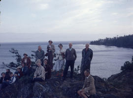
![Group on V. Is. [Vancouver Island] at Nanoose](/uploads/r/null/8/d/6/8d62aa8abb26e5649d3ff49903d0fda750ad864238bf0e4dc1d28ee24dd0b29c/c2584b8a-4cd9-4593-b9e3-8adaa0eeaafe-2005-040_142.jpg)


![West Coast trip [with Sherwood Lett, Arthur Lord, W.O. Banfield] : Our noble vessel [The Bedouin]](/uploads/r/null/1/4/d/14dd0986b77a7390f20565f285896a03467076e632ed443a813d5b36361055e0/dfe4eac3-ed8f-4339-8d51-e23ef4fcb9a8-CVA289-003_142.jpg)
![West Coast trip [with Sherwood Lett, Arthur Lord, W.O. Banfield] : Brailing fish](/uploads/r/null/c/8/a/c8a0408a587b5f8aba7c66deeb0c6812ed37a0e32832894c9d8ecdb0ce7c31b0/00539abd-8467-4d4d-ab2f-37d8ec0cfc74-CVA289-003_142.jpg)
![West Coast trip [with Sherwood Lett, Arthur Lord, W.O. Banfield] : Getting dinner on the "Be...](/uploads/r/null/6/3/2/6326b5d85f9f6e8ae0479b296399bfadef897844da1ebeb760704e402f41d52b/1a5659c2-116a-46f9-8088-cbca5c27066a-CVA289-003_142.jpg)
![West Coast trip [with Sherwood Lett, Arthur Lord, W.O. Banfield] : Some of our catch](/uploads/r/null/3/0/0/30024c016d3fd6a5d456fad118d31feb2b9cd0ecb41b53587b9b8854a96275aa/0a6a75b2-df01-451e-b062-8fb498b1c76f-CVA289-003_142.jpg)
![West Coast trip [with Sherwood Lett, Arthur Lord, W.O. Banfield] : The scow being loaded](/uploads/r/null/6/5/1/6515c8ea886c23f029fd699b055dbfbd7b7ff3f3a7eecbabb212c244aef74630/0cfcce07-0894-4f15-98d9-84b1f4e60d59-CVA289-003_142.jpg)
![West Coast trip [with Sherwood Lett, Arthur Lord, W.O. Banfield] : Dumping the silver horde](/uploads/r/null/0/f/3/0f3e3d90e7bf32b7472b25ce46f3c6c63f78c68e71905c29a86a31077f37a9e4/d90c43e7-7e1e-4992-950b-3aead4760594-CVA289-003_142.jpg)
![West Coast trip [with Sherwood Lett, Arthur Lord, W.O. Banfield] : Starting the brail](/uploads/r/null/2/d/e/2de617b3392489d33f277e962ecd28184efd5f66d425d061b9fb7faaf9e2770a/c8eaff7c-5cc6-4e98-a83f-d36433242500-CVA289-003_142.jpg)
![West Coast trip [with Sherwood Lett, Arthur Lord, W.O. Banfield] : Gathering the net in](/uploads/r/null/e/3/a/e3a3366241397bc9fa4b40afe97704d1bbd555369f8f1bfa50123ec9a339ffe1/ce17d5fa-4a10-4d4c-94d3-590a1a246d62-CVA289-003_142.jpg)
![West Coast trip [with Sherwood Lett, Arthur Lord, W.O. Banfield] : The set complete, lifting the ...](/uploads/r/null/2/f/b/2fb07228d267632e04d07604b9bd34d8219abb57b2b2f08f1cb9d10adb521ca5/2b8db0f5-25df-4eaf-a0fb-6d99ce46baa1-CVA289-003_142.jpg)
![West Coast trip [with Sherwood Lett, Arthur Lord, W.O. Banfield] : Our wolf fish](/uploads/r/null/e/7/e/e7e85141590664ee1841d469cafe03cff3e9aeb691447bd426e0b9845a35da85/5857d61d-6092-4a4b-b617-785e31e77730-CVA289-003_142.jpg)
![West Coast trip [with Sherwood Lett, Arthur Lord, W.O. Banfield] : Our wolf fish](/uploads/r/null/2/0/f/20f109e479db7553825fec5d2918ae27aab724f9e3493bd3374e6a0999a40ad8/f3ed1610-09d6-4d7b-8374-908211993f19-CVA289-003_142.jpg)
![West Coast trip [with Sherwood Lett, Arthur Lord, W.O. Banfield] : Sherwood [Lett] the fisherman](/uploads/r/null/d/8/b/d8bef33ca4b26b007589fcd07f6e9f858830e4076653b29b32fece04c16b16b0/b1895109-062f-4d40-b87f-24ea86fc4cb2-CVA289-003_142.jpg)
![West Coast trip [with Sherwood Lett, Arthur Lord, W.O. Banfield] : Art [Lord] fishing in Trout River](/uploads/r/null/c/c/a/ccab4317f563529cebd8372c99467266b9bf5a80a0101d414ced94d21c286ae4/0798ff25-1601-4f04-8cf7-0fe8a7108d64-CVA289-003_142.jpg)
![West Coast trip [with Sherwood Lett, Arthur Lord, W.O. Banfield] : Lower reaches of Trout River](/uploads/r/null/b/2/e/b2eef641593160732bc00be405bee31d18fcd91a4de91130c9bd34ee2729a531/6c3d55e6-de11-4dcf-b6fc-d5674240eb4c-CVA289-003_142.jpg)
![West Coast trip [with Sherwood Lett, Arthur Lord, W.O. Banfield] : Looking out of Riley's Cove](/uploads/r/null/9/4/1/9419eba203962b56153fcf59f5f913195937aabfd74062251cb908b04476f412/57ca2b33-fbb5-4664-b3b7-29224978fb5f-CVA289-003_142.jpg)
![West Coast trip [with Sherwood Lett, Arthur Lord, W.O. Banfield] : The "Bedouin" in Ril...](/uploads/r/null/0/3/5/035fa0a7507dbc91d4bb5fd635d88f7302bf09a91b80cc5e790885cff7d185cd/20a764f5-2a88-4039-a137-945598d04dc8-CVA289-003_142.jpg)
![West Coast trip [with Sherwood Lett, Arthur Lord, W.O. Banfield] : Lagoon at Megin River](/uploads/r/null/f/2/e/f2ea2140c729b22a745d5966404ed3711eea353fbb7ff509df370ebf8429c98e/af7058e2-36ed-4a0b-bacd-5336166902df-CVA289-003_142.jpg)
![West Coast trip [with Sherwood Lett, Arthur Lord, W.O. Banfield] : Megin River](/uploads/r/null/f/7/2/f7279ddc914ac9b87843e908c97d6652752c2e844bdb916faf19ae7a890dfb89/c2b4ae58-ebd1-4b21-91d3-0d5cbbad0e3b-CVA289-003_142.jpg)
![West Coast trip [with Sherwood Lett, Arthur Lord, W.O. Banfield] : Lagoon in North Arm of Sidney ...](/uploads/r/null/d/a/3/da309305ba5dfbe6fc4d3a975b07fd3a6dc549f236160c2f0002ac52c62d961c/ce137057-6be8-4db2-bcb4-a64e073beadb-CVA289-003_142.jpg)