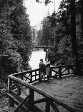
Couple at Capilano Canyon Park
- VPK-S625-: CVA 392-0700
- Item
- [ca. 1960]
Couple at Capilano Canyon Park
![[Cribbing on road at edge of Capilano Creek]](/uploads/r/null/a/3/a359362e8107f6a8feb33a5b82762ea3906af278d6f024af920dd189ce5d2593/ba3f6329-5973-4d12-96d2-90a0a3909935-A16597_142.jpg)
[Cribbing on road at edge of Capilano Creek]
Part of City of Vancouver fonds
Photograph shows what may be Capilano Hotel in background.
![[North Vancouver Ferry dock after heavy snowfall]](/uploads/r/null/0/0/0028ae3094a4938dd211ac37d092913e9ffd760ebb9b02ea5055ef7f470c759f/de0940d0-e78b-4cc9-ac4a-26946fb65613-A16545_142.jpg)
[North Vancouver Ferry dock after heavy snowfall]
Part of City of Vancouver fonds
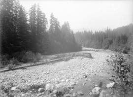
![[Capilano Creek bed]](/uploads/r/null/2/2/227b0d99829332483179bd56e99f24100998eda4ede1212c1623a46196f25ea6/a2ffcc43-9e50-4836-8f91-054a507db579-A16535_142.jpg)
Part of City of Vancouver fonds
Photograph shows dry creek bed and trees.

Capilano lower section of retaining wall
Part of City of Vancouver fonds
![Capilano [Creek] West Channel looking upstream from lower end](/uploads/r/null/1/1/119d1142158a2f8850f1a5e9d3775af1d6018a3291f1f2d51ee974cad3d03416/ddc2b9d6-276b-4887-9393-165796e72cef-A16533_142.jpg)
Capilano [Creek] West Channel looking upstream from lower end
Part of City of Vancouver fonds
![Capilano [Creek] beneath [retaining?] wall at south end, looking eastward](/uploads/r/null/8/2/82c3a40e01fe7a1d90487e7f21e0c3205a6f0dac00ec239d9734f1d0950e13f3/6cfcf3fc-01c4-42b5-bbab-85e8207ca5ad-A16532_142.jpg)
Capilano [Creek] beneath [retaining?] wall at south end, looking eastward
Part of City of Vancouver fonds
![Capilano [Creek] looking upstream from north part of island](/uploads/r/null/a/8/a896dc9c2db3c65159f7e2771c98e330ea3c12b91907157c4698e756dbb1826c/b3e6f5a4-4ff6-456c-84bb-263e82325018-A16531_142.jpg)
Capilano [Creek] looking upstream from north part of island
Part of City of Vancouver fonds
![Capilano Creek [retaining?] wall looking downstream from main channel](/uploads/r/null/e/9/e9025ee05e55eced3e5a22e02e43baa41014dc7b514c53ef148e7e1c1c1f422e/f80f573a-1a6d-45ce-9b5e-3f32a0f192e6-A16530_142.jpg)
Capilano Creek [retaining?] wall looking downstream from main channel
Part of City of Vancouver fonds
Part of City of Vancouver fonds

Part of City of Vancouver fonds

Part of City of Vancouver fonds

Part of City of Vancouver fonds

Wartime cottage next to permanent home in North Vancouver
Part of City of Vancouver fonds

Wartime Housing cottages in North Vancouver
Part of City of Vancouver fonds

Part of City of Vancouver fonds
![Plan of pipe line right of way through D.L. [District Lot] 1242 Gpl. NWD [New Westminster Distric...](/uploads/r/null/c/3/3/c33ab3d09d1709249692d18d57987bf31fd6004f76cbe439d3486f474d8af1b6/62bde213-49bb-45eb-93e1-51857e60fa4b-LEG1153_142.jpg)
Part of City of Vancouver fonds

Sketch plan shewing diversion of Capilano Creek
Part of City of Vancouver fonds

Survey of pipe line road. Made in 1890
Part of City of Vancouver fonds
![Plan of [District] Lot 792, NW [New Westminster] District B.C.](/uploads/r/null/1/9/8/198c71400d4510b6a016d3798f2512c22e9f67b50d5d1c655c276d3ad1c801ff/9801d996-d3f2-480b-86e9-8a1a5217aa41-LEG1153_142.jpg)
Plan of [District] Lot 792, NW [New Westminster] District B.C.
Part of City of Vancouver fonds
![Plan shewing pipe line right of way through Lots 15, 16, 17, 18 & 19 D.L. [District Lot] 673 ...](/uploads/r/null/1/7/c/17c6697bdcbc4acaabcfbd2b60312b51d4b9e442fd113b9376cb994c4cdd707e/3d248d3a-3fca-431f-a491-972fea32373e-LEG1153_142.jpg)
Part of City of Vancouver fonds
![Traverse of pipe line through [District] Lot 764. Made in 1890](/uploads/r/null/e/6/6/e6636344ea453438048b75977e8626a4c402efbe3a164905afded7318afb0e03/db967470-d758-412f-a944-85bc059a5995-LEG1153_142.jpg)
Traverse of pipe line through [District] Lot 764. Made in 1890
Part of City of Vancouver fonds
![Traverse of Capilano Road & pipe line through [District] Lot 594 NWD [New Westminster District]](/uploads/r/null/9/0/3/9037991f2486a9cd4c2d2940da69f422ccad131260700d83f81f8529152d8956/e01b3254-8711-47c6-a530-deb712555586-LEG1153_142.jpg)
Traverse of Capilano Road & pipe line through [District] Lot 594 NWD [New Westminster District]
Part of City of Vancouver fonds
Part of City of Vancouver fonds
Item is a sheet containing an architectural drawing Section through excavation & embankment and a Profile of south boundary Lot 13. The sheet also includes an itemised list of construction cost estimates.
![Plan shewing pipe line right of way through parts of [District] Lots 673, 792, 1248 & 8740](/uploads/r/null/3/e/d/3edc1c60ffff3e127a7deca4ea557003830885586aca147517f20701ee3a0e82/e2a2ed7a-ca07-4658-af4f-9e2675d8a5b6-LEG1153_142.jpg)
Plan shewing pipe line right of way through parts of [District] Lots 673, 792, 1248 & 8740
Part of City of Vancouver fonds

Cadastral map of upper Seymour Creek
Part of City of Vancouver fonds

Tidal flats at mouth of Seymour Creek
Part of City of Vancouver fonds
![Final location of pipe line through [District] Lot 791](/uploads/r/null/3/3/8/338c70bb04cabd4bcf8223c485229014009e6984d8002c854e4d5ff6d11b634e/336af1c6-ee08-4bc2-8f4b-373f2a289a69-LEG1153_142.jpg)
Final location of pipe line through [District] Lot 791
Part of City of Vancouver fonds

Plan of Seymour Creek pipe line between present intake & temporary intake
Part of City of Vancouver fonds
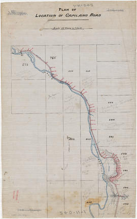
Plan of location of Capilano Road
Part of City of Vancouver fonds
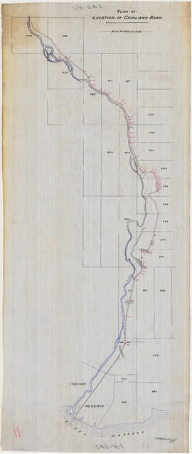
Plan of location of Capilano Road
Part of City of Vancouver fonds

Plan of land which will be flooded at reservoir site above water fall. Seymour Creek
Part of City of Vancouver fonds
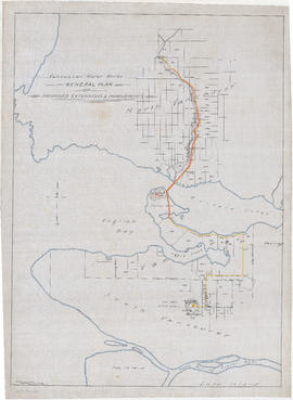
General plan of proposed extension & improvements
Part of City of Vancouver fonds
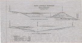
Item is a map which depicts existing and proposed new waterworks infrastructure, including the proposed new Little Mountain reservoir.

Capilano and Seymour water sheds
Part of City of Vancouver fonds
Item is a map which includes topography and waterworks infrastructure such as pipelines, tunnels, intakes, proposed reservoirs, etc.

Plan of pipe lines from intake to tunnel
Part of City of Vancouver fonds
Item is a map which depicts Capilano Creek from Lot 593 to Lot 847, including pipelines and other waterworks infrastructure.

Part of City of Vancouver fonds
Part is the southern half of a map of the Capilano River, depciting the area of the Capilano River valley from the river's mouth at Burrard Inlet north to District Lot 596.
Part of City of Vancouver fonds
Part is the northern half of a map of the Capilano River, depicting the area of the Capilano River valley from District Lots 595 and 602 north to the dam located in District Lot 673.

Plan of location of Capilano Road
Part of City of Vancouver fonds
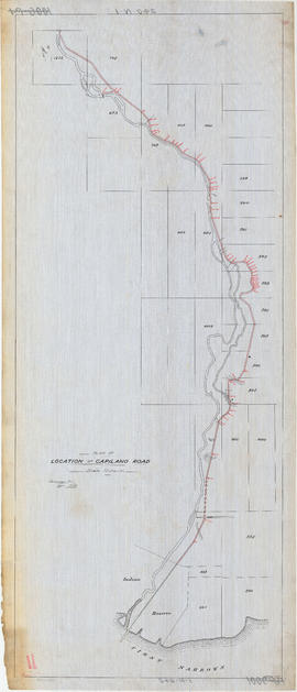
Item is a map depicting the Capilano River valley, with rough sketches of topography. The map shows the route of Capilano Road and a water pipeline route.
![Profile of pipe-line : Capilano intake to Little Mt. [Mountain] reservoir](/uploads/r/null/f/d/e/fde7fb6226629fad04bbf9be7365df117c8a21327882aba29740dae663d9c8fb/a5da6578-eab7-4510-9aa2-cc05f6ce537d-MAP866_142.jpg)
Profile of pipe-line : Capilano intake to Little Mt. [Mountain] reservoir
Part of City of Vancouver fonds
![St. George's School Graduation Dance [at] Canyon Gardens](/uploads/r/null/5/b/5b3da9744d08a70383e8d090ccfc9124276e2cf1179d25090cc419df71bb6562/55c1c95e-15b3-4a97-9c15-635bb6fdadaa-A69619_142.jpg)
St. George's School Graduation Dance [at] Canyon Gardens
Part of St. George's School fonds
Group portrait

St. George's School Graduation Dance Canyon Gardens - June 1953
Part of St. George's School fonds
Group portrait

Grouse Mountain Highway from Thunderbird Bridge
Photograph shows 2 men and a tractor on bridge.

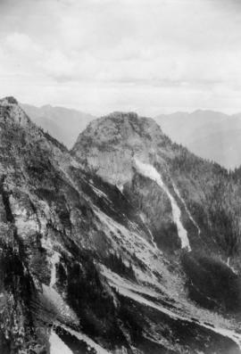
Goat Mountain from Grouse Mountain

The Camel from Grouse Mountain

The Pyramid and the Camel from Crown Pass

Goat Mountain from clearing on Grouse Mountain

Photograph shows 6 hikers in clearing.
Crown Ridge, Grouse Mountain Park

