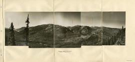
Panorama - Green River Valley from Green lake toward Pemberton Valley
- COV-S40-MAP 939-: LEG1153.034
- Item
- [1931]
Part of City of Vancouver fonds
8 results with digital objects Show results with digital objects
Panorama - Green River Valley from Green lake toward Pemberton Valley
Part of City of Vancouver fonds

Topographical map of parts of the Cheakamus and Green River Valleys
Part of City of Vancouver fonds
Item is a copy of a Government of British Columbia Lands Department map which has been used as a base map to depict elements of the proposed development. Annotations depict acreages of affected areas.
![Longitudinal section along [centre line] of dam sites at north end of Green Lake](/uploads/r/null/7/4/a/74af74789da62d7da66c012dd18dd964e4e83151ac5f0b139a53843bce6ccfe6/974ff05f-0f29-4e65-b818-c663b1a236e1-MAP1142_142.jpg)
Longitudinal section along [centre line] of dam sites at north end of Green Lake
Part of City of Vancouver fonds
Item is a sheet depicting 2 profiles: one of dam no. 1 at railway crossing at 2247+763 and one of dam no. 2 at the head of the Green River (Green Lake).
Green River and Soo River maps and sections
Part of City of Vancouver fonds
Part is one side of a sheet depicting rough sketches of survey data from surveys of the Green and Soo rivers, including maps and cross-section profiles of various parts of the rivers.
Green River and Soo River profiles and sections
Part of City of Vancouver fonds
Part is one side of a sheet depicting rough sketches of survey data from surveys of the Green and Soo rivers, including profiles and cross-section profiles of various parts of the rivers.

Soo River profile from Green River junction west 6 miles 3820 ft
Part of City of Vancouver fonds

Profiles of sections of Green & Soo Rivers
Part of City of Vancouver fonds
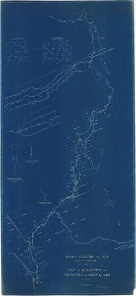
Map of headwaters of Cheakamus and Green rivers
Part of City of Vancouver fonds
Item is a map sheet showing the results of the hydroelectric surveys of the upper Cheakamus River, Green Lake and Green River. The sheet includes 3 cross sections of the Cheakamus River.

General plan of works to be constructed at Nairn Falls. Green Lake. Lillooet District, B.C.
Part of City of Vancouver fonds
Item is a topographical map showing the location of proposed power house, dam and other hydro-electric infrastructure at the north end of Green Lake, tunnel, and the Pacific Great Eastern Railway right-of-way along the northern edge of Green Lake.
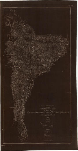
Topographical map of parts of the Cheakamus and Green River valleys
Part of City of Vancouver fonds