![856 E 7th Ave [taken] from road in front of house](/uploads/r/null/1/e/1/1e169ed63448aab64322b92f24f6a0030be4c303645c922538a70931ea5b0441/05d9134e-b168-4f4c-a951-ecbce0562b66-2018-034_142.jpg)
856 E 7th Ave [taken] from road in front of house
- AM1376-: 2018-034.1
- Item
- [195-]
Item is a photograph showing houses along East 7th Avenue and two kids playing with a sled in the snow
2306 results with digital objects Show results with digital objects
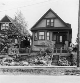
856 E 7th Ave [taken] from road in front of house
Item is a photograph showing houses along East 7th Avenue and two kids playing with a sled in the snow
856 E 7th Ave with fences yard
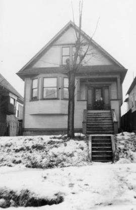
856 E 7th Ave, Barb and Paddy on front porch
[Home of Joseph Ogden - 448 East 6th Avenue]
Item is a photograph showing a group on the front porch of the house and a man sitting on the second storey porch. Also inscribed on the verso is the name Mrs. A. W. Maxwell.

Mount Pleasant School class photo
Item is a photograph showing students and principal of Mount Pleasant School. Marie Rivere (nee Gauvreau) is pictured third from left in the second row. Annotation on verso: "Principal possibly Mr. Jamieson or Mr. Baxter."
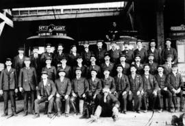
Conductors and motor men at Mount Pleasant Barn
Item is a photograph showing conductors and motor men at Mount Pleasant Barn. Mt. Pleasant streetcar and several other streetcars in background. Pictured front row (L-R): Jack Frizzell, Anderson, Grant, Geo. Lenfesty, Jim McCann, Snider, C. Bennett, Andy Keith, Wm. Braim, Ed Manning, Harry Hews (sitting on ground beside dog). Pictured centre row: Jack Howes, Hank Cameron, Tom Routley, McNab, Geo. Martin, John Tibb, Jim Barton, Ave Ross, Bob Brunt, John Perry, Charley Tanner. Pictured back row: Jack Paxman, Harry Vanderwalker, Jim Marshall, Harry Gibbs, McLennan, Brearton, Ross, Paddy Davis, John Jefferies, Jack Clode, Geo. Sherman, Jack Gardner, Harry Hews (on top of car).
Exterior of house at corner of Prince Edward Street and East 13th Avenue
Item is a photograph showing a house at the Prince Edward Street and East 13th Avenue. Writing on back: "1916 Kingsway, corner of Pr. Edwar and 13th Ave before 12th Ave was cut through, a tennis court was on north side, [Mr. Underhill] lived here prior to Dr. W.A. Moffatt. I took picture - [Morris Moffatt]."

Kingsway south-east of 12th Avenue, taken from 396 Kingsway

Kingsway looking north, Prince Edward cuts in here, also 12th Ave E., taken from 396 Kingsway

City Hall, north facade from lawn
Broadway and Keith Drive garbage fill
Item is a photograph showing the former city landfill site at China Creek park area. Inscription on back states "from E/S lane west of Clark Dr. view west".
Broadway and Keith [garbage fill]
Item is a photograph showing the former city landfill site at China Creek park area.
Broadway and Keith [garbage fill]
Item is a photograph showing the former city landfill site at China Creek park area.
Broadway and Keith [garbage fill]
Item is a photograph showing the former city landfill site at China Creek park area.
Broadway and Keith [garbage fill]
Item is a photograph showing the former city landfill site at China Creek park area.
Broadway and Keith [garbage fill]
Item is a photograph showing the former city landfill site at China Creek park area. City Scavenging Department staff are at work.
Item is a photograph showing the former city landfill site at China Creek park area. City crews are working on the fill site.
Item is a photograph showing the former city landfill site at China Creek park area. City crews are working on the fill site.
Item is a photograph showing the former city landfill site at China Creek park area. Site no longer shows garbage and is covered over with dirt.
Broadway and Keith completed [garbage fill]
Item is a photograph showing the former landfill site covered over as a grass field.
Item is a photograph showing the former cycle track at Glen Drive and East 8th Avenue.
Mount Pleasant Housing Society financial statements
Item is a report prepared by the Mount Pleasant Area Council and Ratepayers' Association regarding the creation of the new Guelph Park.
Mount Pleasant : a neighbourhood history
Item contains information on early homes, original transportation routes through the area, and industrial encroachment, and includes a bibliography.
Item is a proposal to renovate and restore Vancouver landmark Postal Station C.
It's the main event on Main Street
Item is a portfolio containing facts on the building and handbills advertising forthcoming activities.
Guide to the early history and development of Brewery Creek Basin
Item includes maps of early trails, streams, industries.
From Cambie to Clark: a look at Mount Pleasant
Item is a collection of research papers by students from Vancouver Community College.
From Cambie to Clark : a look at Mount Pleasant, past and present
Item is a collection of research papers by students from the Humanities Department, Vancouver Community College.
Mount Pleasant telephone business directory
Our house : Mount Pleasant Neighbourhood House newsletter
![R.C.M.P. [Royal Canadian Mounted Police] Building, Main Street south entrance](/uploads/r/null/7/8/b/78bfd9357beddc228b5ad9726f607de307afa28829edd3a24c136b54b7882a16/ecded68b-962b-4fa7-a698-1c9b933fa643-CVA70-12_142.jpg)
R.C.M.P. [Royal Canadian Mounted Police] Building, Main Street south entrance
Part of Art Grice fonds
Item is a photograph of the secondary entrance of the R.C.M.P. building (later, Heritage Hall, 3102 Main Street) at the corner of Main Street and 15th Avenue showing a low angle view of the windows, ceiling, and architectural details above the doorway in the smaller southern tower. Also visible are some of the sculptures decorating the frieze above the second level.
![R.C.M.P. [Royal Canadian Mounted Police] Building, Main Street, north facade and clock tower](/uploads/r/null/f/1/3/f13b3c0d36643beee7d88d19a63a13b1aca3588fc2c2589a01baad7e2530b923/cc2920b3-3d9c-474d-b2c5-38619a59b10f-CVA70-13_142.jpg)
R.C.M.P. [Royal Canadian Mounted Police] Building, Main Street, north facade and clock tower
Part of Art Grice fonds
Item is a photograph of the (northern) clock tower, north facade, and frieze of the R.C.M.P. building (later, Heritage Hall, 3102 Main Street) at the corner of Main Street and 15th Avenue.
![R.C.M.P. [Royal Canadian Mounted Police] Building, Main Street, main entrance](/uploads/r/null/5/b/5/5b50e92503f01bd8a74fc5892f9f3708bb94bc9362fe91870501831f4d5c604c/10505865-147b-4588-98fc-e331a460607f-CVA70-14_142.jpg)
R.C.M.P. [Royal Canadian Mounted Police] Building, Main Street, main entrance
Part of Art Grice fonds
Item is a photograph of the main entrance of the R.C.M.P. building (later, Heritage Hall, 3102 Main Street) at the corner of Main Street and 15th Avenue showing the doorway, columns, windows, and architectural details above the main doorway. Also visible are some of the sculptures decorating the frieze above the second level.
![R.C.M.P. [Royal Canadian Mounted Police] Building, Main Street, clock tower detail](/uploads/r/null/4/7/8/4784077b86de352a04cf10904113237db0b62ab4b677e8244ec70993c8e4d32b/a94b914d-e305-45f2-8e7e-0bb76a62637e-CVA70-15_142.jpg)
R.C.M.P. [Royal Canadian Mounted Police] Building, Main Street, clock tower detail
Part of Art Grice fonds
Item is a photograph of the upper portion of the (northern) clock tower of the R.C.M.P. building (later, Heritage Hall, 3102 Main Street) at the corner of Main Street and 15th Avenue. The item details the clock face, tower roof, flag pole, lightning rods, and other architectural features.
![R.C.M.P. [Royal Canadian Mounted Police] Building, Main Street, west facade](/uploads/r/null/a/d/b/adbc09f89c670832271e75247cbd4dc4e4032bbb8407a3cad970b27809a0edf5/7a73d915-c683-494d-b735-78b65a7f1006-CVA70-16_142.jpg)
R.C.M.P. [Royal Canadian Mounted Police] Building, Main Street, west facade
Part of Art Grice fonds
Item is a photograph of the whole west (Main Street) facade of the R.C.M.P. building (later, Heritage Hall, 3102 Main Street) at the corner of Main Street and 15th Avenue. Both towers, entrances and all architectural features are visible.

Mount Pleasant and False Creek

Recording of first Centennial song at Griffiths Gibson Productions
Recording of first Centennial song at Griffiths Gibson Productions

Part of City of Vancouver Archives technical and cartographic drawing collection
Item consists of a planning map depicting the eastern portion of False Creek and surrounding areas.

Part of City of Vancouver Archives technical and cartographic drawing collection
Item consists of a large scale site plan, depicting a proposed development in False Creek [Expo 86?] annotated on top of what appears to be a City planning map. The plan appears to depict part of the Concord Pacific development.
![Vancouver, B.C. Plan showing location of water pipes, hydrants, etc. [Fairview slopes]](/uploads/r/null/6/9/69e0d6904facfa2a814069c15122fba46fc4d8077bff76402e95484a4b13d4d8/313b8940-1e98-45d4-b077-abe0f6bee66a-MAP72_142.jpg)
Vancouver, B.C. Plan showing location of water pipes, hydrants, etc. [Fairview slopes]
Part of City of Vancouver Archives technical and cartographic drawing collection
Item is a map showing the location of water pipes and hydrants for the area bounded by Scotia Street, False Creek, Spruce Street and Tenth Avenue (D.L. 526, D.L. 302 and D.L. 200). Block 6 in D.L. 200 was covered by an overlay depicting a later sub-division. Pipes and hydrants are shown in various coloured inks to indicate installation date. Annotations have been drawn on a base map that was part of a larger map.
Vancouver (B.C.). Water Works Department

Part of City of Vancouver Archives technical and cartographic drawing collection
Item is a map showing the location of water pipes and hydrants for the area from Victoria Drive to False Creek to Prince Edward Street to 16th Avenue (D.L. 264A). Pipes and hydrants are shown in various coloured inks to indicate date of installation.
Vancouver (B.C.). Water Works Department

Part of Pacific Press fonds

Streetcar on Kingsway at Main Street
Part of Pacific Press fonds

Streetcars on Kingsway at Main Street, commencement of longest paved highway in the world
Part of Pacific Press fonds

Two women pushing strollers in Robson Park
Part of Pacific Press fonds

Residential street in Mount Pleasant area
Part of Pacific Press fonds

Homes with stone walls in Mount Pleasant area
Part of Pacific Press fonds
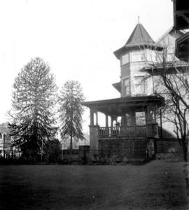
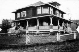
Home with turret and verandah in Mount Pleasant
Part of Pacific Press fonds