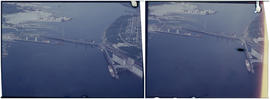
![Vancouver, B.C. East of N. [north] End of Lion's Gate Br. [bridge]](/uploads/r/null/6/c/1/6c17477fe4843e6552e79e511c4a8ea7aeb8ec20926264b8101326b6d03700e6/f3eca68f-c724-4044-8bce-bb4d229a2568-2014-055_142.jpg)
Vancouver, B.C. East of N. [north] End of Lion's Gate Br. [bridge]
- AM1376-: 2014-055.01
- Item
- June 22, 1957
Vancouver, B.C. East of N. [north] End of Lion's Gate Br. [bridge]
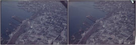
![Vancouver, B.C. N. [north] W. [west] of Burrard Bridge](/uploads/r/null/c/9/b/c9bc62f0498b0fd931c76b545c4eaaf97dd1b608f5d18f97f2f49f032f47eba1/65847175-475d-4b72-b005-c9bed2aa284d-2014-055_142.jpg)
Vancouver, B.C. N. [north] W. [west] of Burrard Bridge
![Vancouver, B.C. Cloverleaf - N. [north] End Granville Bridge](/uploads/r/null/a/1/c/a1ca23293aba4a0df735121e9f46a98d76eaf6d0141da0d7cf5437c9a109c4b6/1a0404fe-80ee-4ef0-8cae-911f5ab9c506-2014-055_142.jpg)
Vancouver, B.C. Cloverleaf - N. [north] End Granville Bridge
2nd Narrows Bridge under Construction

Vancouver, B.C. Burrard Bridge
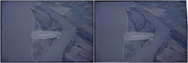
![Vancouver, B.C. N. [north] End Lion's Gate Bridge](/uploads/r/null/6/f/e/6feff36adf72e7a2b8184d907d1a619f3fb3c9d6f42e1f57abe09c79289129ac/51d5d38f-bf43-4380-8c69-4134019a091c-2014-055_142.jpg)
Vancouver, B.C. N. [north] End Lion's Gate Bridge

Vancouver, B.C. University of British Columbia

Woodward's New Development 1k.


Vancouver Airport & Admin buildings

Ambleside & West Lion's Gate Bridge
![Vancouver, B.C. Cambie Br. [bridge]](/uploads/r/null/d/a/9/da9942388ff02d1a8b65d1bfeb1c75a017e0cd4ae269e5557f50a4cb73df2adc/9b8ee4bb-f63f-4874-9e80-aeb2fd1058c2-2014-055_142.jpg)
Vancouver, B.C. Cambie Br. [bridge]

![Vancouver, B.C. Connaught Br. [Cambie Bridge] and west](/uploads/r/null/8/1/2/812afcfdc1ae047980e6d5f922d44782e2cc8b2e14671603fe495311c69a4120/22405b60-cda0-4fc6-bd59-01a4219b4892-2014-055_142.jpg)
Vancouver, B.C. Connaught Br. [Cambie Bridge] and west

Vancouver, B.C. University of British Columbia

Vancouver looking north from 22nd Avenue
![[View of] Dominion Mills, Ltd. South Vancouver, B.C.](/uploads/r/null/3/d/3df103cdd0c70f0cee1a01cdc4efef424d87ee1cc70cc1584551d8e4149d6e11/a0506029-def0-4762-b5d9-caf30483e8ab-CVA1376-25_142.jpg)
[View of] Dominion Mills, Ltd. South Vancouver, B.C.
Photograph shows an oblique aerial view of the mill.
![[Aerial view of Vancouver]](/uploads/r/null/9/b/9b3acec26123edc53f11bf2f41f3286d09254ffea9918cd31b6715395ebe18d0/26473909-fe49-4474-8c3f-05eb1e8ab059-CVA1376-252_142.jpg)
Oblique view showing Fairview, Vancouver General Hospital, False Creek and the Expo 86 and other sites under development on the north side, Granville Island, Granville Bridge, Burrard Bridge, Yaletown, Downtown, the West End, Stanley Park and the Lions Gate Bridge, North Vancouver and The Lions in the background
![[Aerial view of fire at Vancouver sawmill]](/uploads/r/null/2/6/261c182ef20aa4aa00d0b46917096bf17c339730ec5975e81a6c1fbc2b63158f/05be5137-bdbf-42ad-a142-3e73d5538015-A71287_142.jpg)
![[R.C.A.F. Maritime Air Command plane No. 102 flying over English Bay]](/uploads/r/null/1/3/13b6c7a118ed10801cfbe633df28806771f06f62a484edbf5de83c5acd20e0a4/ff8af309-b1af-4c30-9216-ba8a2859660d-A71302_142.jpg)
[R.C.A.F. Maritime Air Command plane No. 102 flying over English Bay]
Oblique view showing the Vancouver Maritime Museum and Kits Point residences in the foreground, and the West End, Downtown, Stanley Park and Burrard Inlet in the background.
![[Aerial photograph of downtown Vancouver looking north]](/uploads/r/null/2/4/24032a0f19bc217e5bb533d7218824f932301e972f1020a352118b50afcf8a93/8e2450db-6794-4283-95a6-7641bc80437d-A69847_142.jpg)
[Aerial photograph of downtown Vancouver looking north]
Photograph shows an oblique view of the north shore of False Creek including the C.P.R. Roundhouse, Yaletown, Cambie Bridge (old), Sweeney Cooperage, Georgia Viaduct, Post Office building under construction, Pier "B/C", Coal Harbour, Stanley Park, Lions Gate Bridge and a view of North and West Vancouver.
![[Aerial view of Downtown Vancouver looking south from Burrard Inlet]](/uploads/r/null/3/2/32bc12be65a895f144d669768ee019e6abc83bc4018b11b3ecf96930fbd98786/024e645a-ce5d-4e73-a4e1-efb2ad9b7995-A71518_142.jpg)
[Aerial view of Downtown Vancouver looking south from Burrard Inlet]
Photograph shows Canada Place under construction, the SeaBus terminal, Waterfront Station (formerly the C.P.R. Station), the Marine Building, Harbour Centre and False Creek and Granville Island in the background
![[Aerial view of rail yard and industrial area]](/uploads/r/null/9/f/9f92989deb2b54597c6743bd67717653fc644c23b6fc48e55d2e1b9dbf6e8489/763b5a38-9eae-4b16-bedc-45ca5c32d888-A71602_142.jpg)
![[Aerial view of Richmond Centre mall]](/uploads/r/null/2/e/2ee69f17353dd5eafd9d3c5d8d0ae7f95f74b5669c564c68a4c72ffafb9cda20/e0752fe7-4588-4c42-a25c-ef561bf4ed68-A71603_142.jpg)
[Aerial view of Richmond Centre mall]
Item is a photograph showing the Richmond Centre shopping mall as well as Samuel Brighouse Elementary School and Minoru Park.
![[Aerial view of industrial area]](/uploads/r/null/5/d/5dd69372e15c5f349b4b4b8cdb7a12063cbbf02d158ab97d57ba863214b5c209/5f3baa69-a2f9-4adb-a590-4b420086d51d-A71604_142.jpg)
![[Aerial view of shopping centres]](/uploads/r/null/d/2/d21dcc14ced0356484b5666789f851fac68a175214b4718fae1444fec7417944/1f264270-6b68-43e6-be2e-f5b59df5d035-A71605_142.jpg)
![[Aerial view of a shopping centre]](/uploads/r/null/1/5/156ef6b6f2bbd9391835c1b458d9e5fa7ba0e39f8fd2abeb2812e6ee46100008/a8e98ea8-442f-4d1a-acbf-ff2cc8319fa1-A71606_142.jpg)
![[Aerial view of shopping centres]](/uploads/r/null/1/0/10ff59da2ba368988732f96fd1cd6e8fa091b0be501fa556439f7a93e5f7da6e/ac882c6d-a7cb-45e1-94f7-e89b0f645a16-A71607_142.jpg)
![[Aerial view looking west over Burnaby towards Vancouver]](/uploads/r/null/3/e/3ee0bad707202c9fbcaad91d585345ec93cbe9ec0be93643a8c82dd4f323bdde/1d10f88f-abea-4b79-b07a-e27dfe5d6cd0-A71608_142.jpg)
[Aerial view looking west over Burnaby towards Vancouver]
Oblique view showing the former Kelly Douglas site (now Metrotown Mall), Kingsway and Central Park
![[Aerial view looking west over Burnaby towards Vancouver]](/uploads/r/null/a/1/a1972aaa0fedf64a8da64c0a3f99647764ec26034813d610dc060d54afdfe1bf/0b1d7503-6b52-44de-a829-67274f54d77c-A71609_142.jpg)
[Aerial view looking west over Burnaby towards Vancouver]
Oblique view showing the former Kelly Douglas site (now Metrotown Mall), Kingsway and Central Park
![[Aerial view over Burnaby]](/uploads/r/null/0/3/037ecb1cc7577fad52b33cbaec0eaf096ffaba433660c44f741e17d03dfdfabd/2b0ca722-06fa-4545-9dc1-41843e30b8ec-A71610_142.jpg)
Oblique view showing the area between Canada Way, Sumner Avenue, Willingdon Avenue and the Trans Canada Highway including the Villa Inn and a hotel under construction
![[Aerial view over Burnaby]](/uploads/r/null/0/0/000c0196f6c810d76eb723bd8a3264ee3e43b53d6e32e7ad08a8e01e6712e7d7/75a245f8-8a3d-404d-bc50-219fadd7d908-A71611_142.jpg)
Oblique view showing the area between Canada Way, Sumner Avenue, Willingdon Avenue and the Trans Canada Highway including the Villa Inn and a hotel under construction
![[Aerial view over Burnaby]](/uploads/r/null/3/3/331b6e68239af4202f445b5284f51f9a4cb22c20b12ed83ca8ea7f7333df1d07/025da952-0a47-40b0-8988-6a3f80af1576-A71612_142.jpg)
Oblique view showing the area between Canada Way, Sumner Avenue, Willingdon Avenue and the Trans Canada Highway including the Villa Inn and a hotel under construction
![[Aerial view looking northwest towards the Downtown waterfront]](/uploads/r/null/c/c/cc62f979c7614b3405e2bfbfcd8cf6172232e958fc2dcd17a970dbbf3d28b4d8/4699d55d-d238-4161-854b-fa983bd7d738-A71613_142.jpg)
[Aerial view looking northwest towards the Downtown waterfront]
Oblique view showing Harbour Centre (formerly Spencer's Department Store) and Lookout, the C.P.R. (Waterfront) Station, C.P.R. Pier B-C, the Marine and other buildings
![[Aerial view looking over the Downtown waterfront]](/uploads/r/null/1/6/1644eebceda09466c9aac6a8534ea82b04164ab39d5d756ec4cc902d5ba16e30/d4c9f855-498d-4971-a368-0f672d3a89a4-A71614_142.jpg)
[Aerial view looking over the Downtown waterfront]
Oblique view showing Burrard Street and the Marine and other buildings

Oblique view showing a biplane over the bridge and the Prospect Point Signal Station
![[Aerial view of biplane over The Lions]](/uploads/r/null/2/0/2072f7cce07a632f3ed3e2f7ebad407f424ac73da89d95c5fe835c233ab20ae7/b74a8663-848f-4e8f-a407-1de5125f4f06-A71798_142.jpg)
[Aerial view of biplane over The Lions]
Oblique view showing a biplane over the bridge and the Prospect Point Signal Station
Item is aerial view from downtown Vancouver showing Coal Harbour, Deadman's Island and the North Shore Mountains.

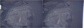
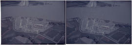
Aerial view of eastern portion of Vancouver Harbour showing Vancouver Terminal

Aerial view looking south towards Vancouver Terminal Company grain elevators and docks


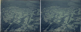
Aerial view of Little Mountain area
Item is an aerial photograph showing an oblique view of the Little Mountain area.

Aerial view of Brockton Point in Stanley Park looking south