Scenery Shop pamphlet : side 1
- AM1519-: PAM 1938-7-: LEG1319.119
- Part
- 1938
Part consists of text showing the legends of Siwash Rock and Thunder Bird "Tootooch" with illustrations, and advertises tourist souvenirs sold in the Scenery Shop.
11168 results with digital objects Show results with digital objects
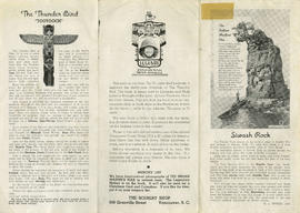
Scenery Shop pamphlet : side 1
Part consists of text showing the legends of Siwash Rock and Thunder Bird "Tootooch" with illustrations, and advertises tourist souvenirs sold in the Scenery Shop.
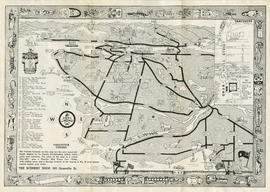
Scenery Shop pamphlet : side 2
Part contains a map showing Vancouver, Surrey, Coquitlam, Burnaby, North Vancouver, Sea Island and Lulu Island illustrated with people, animals, vehicles and buildings. The map shows few street names, tourist destinations, and the location of the Scenery Shop in an inset map. A border with First Nations symbols surrounds the map and is accompanied by a legend of symbols.

Shortest - fastest : fair to fair : United Air Lines : side 1
Part contains text about United Air Lines service including reservation and schedule information.

Shortest - fastest : fair to fair : United Air Lines : side 2
Part contains a map showing United Air Lines destinations accompanied by text with information about fair to fair service.

This time . . . go by bus : Pacific Stage Lines : side 1
Part contains cover of pamphlet, contact and rate information, and is illustrated with photos of a bus depot, and the interior and exterior of buses with passengers.

This time . . . go by bus : Pacific Stage Lines : side 2
Part contains text addressing Pacific Stage Lines schedule, accommodations, route, and bus terminal information. A map accompanies text showing bus routes from Vancouver through the United States and up to Halifax.

City map and points of interest of Vancouver, British Columbia : side 1
Part contains recommendations for tourists visiting Vancouver, including what to see, scenic boat trips, sports facilities, facts and historical events. Part is illustrated with photos of Vancouver scenery and buildings.

City map and points of interest of Vancouver, British Columbia : side 2
Part contains a map showing principal streets located in Vancouver, North Vancouver, West Vancouver, Burnaby, Lulu Island, and Sea Island. Accompanying map is a list of directions to popular destinations.
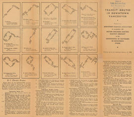
Transit routes in downtown Vancouver : side 1
Part contains illustrations of the downtown Vancouver portions of the B.C. Electric transit routes and text descriptions of all B.C. Electric transit routes in Vancouver, New Westminster, North Vancouver, Richmond, and Burnaby effective up to and including February 15, 1950.

Transit routes in downtown Vancouver : side 2
Part contains a continuation of text descriptions of transit routes from side 1. Part also contains a map showing B.C. Electric transit routing in downtown Vancouver. Map includes street names and a legend of routes and stops.

Welcome to Vancouver, Canada : side 1
Part contains advertisements and information about Vancouver points of interest illustrated with photographs of Stanley Park, the Lions Gate Bridge, Horseshoe Bay and Kitsilano Beach.

Welcome to Vancouver, Canada : side 2
Part contains a map of Vancouver, North Vancouver, West Vancouver, Burnaby, Lulu Island and Sea Island. Map shows principal street names, parks, beaches, golf courses and fishing spots.

The scenic route of British Columbia : Pacific Great Eastern Railway : side 1
Part contains the pamphlet cover page and a map showing the route of the Pacific Great Eastern Railway. Map shows town names, bodies of water, and bridges. Map extends from the Canada/U.S. border to Summit Lake.

The scenic route of British Columbia : Pacific Great Eastern Railway : side 2
Part consists of text listing points of interest along the Pacific Great Eastern Railway route. List shows the mileage and the altitude of each point of interest.

Visitor's map of Vancouver : side 1
Part contains two inset maps, one map of Stanley Park showing trails, bridle paths and traffic direction, and one map of Downtown Vancouver showing 24 points of interest and street names. Part also contains text with tourist information including traffic rules, and locations of popular destinations.

Visitor's map of Vancouver : side 2
Part contains a visitors map of Vancouver extending from the Straight of Georgia to Grouse Mountain to Surrey to Westminster Highway. Map shows bodies of water, principal street names, beaches, and some tourist destinations. Map is illustrated with cartoons.

Victoria and Vancouver Island 1954 Princess routes for passengers and motor cars : side 1
Part contains textual information about Vancouver, Port Angeles, and Seattle ferry routes, including travel documents required for passengers. Text is illustrated with photographs showing ferry interiors, exteriors, and an aerial view of Vancouver.

Victoria and Vancouver Island 1954 Princess routes for passengers and motor cars : side 2
Part contains textual information about rates and fares, ferry service schedules, accommodations. Text is illustrated with photographs of ferry interiors, hotels and an inset map showing the ferry routes. Map extends from the Pacific Ocean to Olympia, Washington to Campbell River to Everett, Washington.
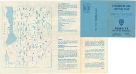
Civil Defence evacuation and survival plan for Greater Vancouver target area : side 1
Part contains the front and back covers of the pamphlet and a map showing evacuation assembly points at docks and school playgrounds for people without cars. Part also contains text with evacuation instructions. Map is courtesy of Vancouver School Board, text and additions made to map by Vancouver Civil Defence.

Civil Defence evacuation and survival plan for Greater Vancouver target area : side 2
Part contains inside of pamphlet cover with evacuation instructions and a map showing evacuation routes for Greater Vancouver. Map was created by Evergreen Press and added to by Vancouver Civil Defence. Evacuation routes are represented by colour coding and arrows accompanied by a legend on the top left corner of map. Map shows principal street names and extends from the Straight of Georgia to Lynn Valley Road to Brunette Road to Westminster Highway.
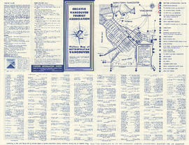
Visitors' map of metropolitan Vancouver : side 1
Part contains one inset map of Downtown Vancouver showing 26 points of interest and street names. Part also contains text with tourist information including traffic rules, and a list of businesses and services.

Visitors' map of metropolitan Vancouver : side 2
Part contains a visitors map of Vancouver. Map extends from the Straight of Georgia to Grouse Mountain to North Road to Westminster Highway. Map shows bodies of water, principal street names, beaches, and some tourist destinations. Map is illustrated with cartoons.

Map : Puget Sound Country, Victoria, Vancouver Island and Southern British Columbia Coast : side 1
Part contains textual information about Black Ball Line ferry service and two inset maps. Maps show close ups of ferry service from Nanaimo and from Vancouver/Horseshoe Bay.

Map : Puget Sound Country, Victoria, Vancouver Island and Southern British Columbia Coast : side 2
Part contains a map showing Black Ball Line ferry routes and other ferry routes on the Georgia Straight and Juan de Fuca Straight. Map extends from Barkley Sound to Garibaldi Provincial Park to Mount Baker to South Bend, Washington.

The Lower Mainland traffic system : side 1
Part contains textual information about the Lower Mainland highway system. Part includes a letter from Minister Gaglardi and is illustrated with photographs of Lower Mainland highways.
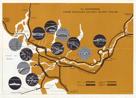
The Lower Mainland traffic system : B.C. Government Lower Mainland Highway Traffic System
Part contains a map showing planned, under construction, and completed double and single lane highways on the Lower Mainland. Map extends from Langdale to Hope to Tsawassen. Map includes illustrations of various bridges, tunnels and ferries that are part of the highway system.

Part contains textual information about picnic sites across the Lower Mainland. Picnic sites are numbered and correspond to numbers located on the map on the other side of pamphlet.
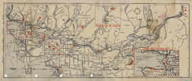
Part contains a map showing picnic sites across the Lower Mainland. Map extends from Straight of Georgia to Alice Lake to Cascade Mountains to Limestone, Washington. Map includes two inset enlargement maps of Horseshoe Bay and Squamish, and of Stanley Park to Spanish Banks.

Visitors' map and guide to metropolitan Vancouver : side 1
Part contains one inset map of Downtown Vancouver showing twenty-seven points of interest and street names. Part also contains text with tourist information including traffic rules, and a list of businesses and services.

Visitors' map and guide to metropolitan Vancouver : side 2
Part contains a visitors map of Vancouver extending from the Straight of Georgia to Grouse Mountain to North Road to Deas Island Tunnel. Map legend shows signs for scenic drives, parks, fishing areas, totem poles, scenic views, pools and beaches, boat moorages, and highway route numbers.

Wider toll-free telephone calling, no long distance charges : side 1
Part contains textual information advertising new rates and the abolishment of long distance charges between Lower Mainland areas. Part contains inset map showing areas of telephone service.

Wider toll-free telephone calling, no long distance charges : side 2
Part contains a table showing telephone plans available for different areas including Vancouver, New Westminster, Richmond, Whalley, Ladner - Beach Grove, Newton, and Port Coquitlam.

Vancouver visitor's fun map : side 1
Part contains cover of visitors map, advertisements for Vancouver tourist destinations and businesses, and is illustrated with photographs of Vancouver scenery.

Vancouver visitor's fun map : Visitors map of Greater Vancouver
Part contains a visitors map of Vancouver extending from the Straight of Georgia to Grouse Mountain to North Road to Deas Island Tunnel. Map legend shows signs for scenic drives, parks, fishing areas, totem poles, scenic views, pools and beaches, boat moorages, and highway route numbers. Part also contains an inset map showing an enlargement of Downtown Vancouver with twenty-seven tourist destinations located on the map.

Kingsway-Boundary Industrial Centre to light industrial rail customers : side 1
Part contains a map showing location of Kingsway-Boundary Industrial Centre and information about the centre for light industrial rail customers. Map contains legend showing major arterial highways, highways under construction, main roads, and municipal and city boundaries. Map extends from Coquitlam to North Vancouver to University Endowment Lands to Westminster Highway.

Part contains a map showing the site plan for Kingsway-Boundary Industrial Centre. Map contains hand colored legend showing city owned property in orange, privately owned property in green and lanes in blue. Hand colored lots have been annotated by hand with numbers.

Vancouver public aquarium, Stanley park : side 1
Part contains cover of pamphlet with illustrations of fish, and a map showing general location of the Vancouver Aquarium with directions.

Vancouver public aquarium, Stanley park : side 2
Part contains textual information about the Vancouver Public Aquarium, illustrated with photographs showing species on display at the aquarium.

Downtown Vancouver Association historical trek: map
Downtown Vancouver Association historical trek: key
Part is the key to the walking tour on the other side of the sheet. Tour highlights are numbered and named.

Automobile road map of Vancouver Canada : side 1
Part contains textual information including points of interest, Canadian customs regulations, ferry timetables and rates. Part also contains two inset maps. A map of the Okanagan Circuit is in the top left corner, showing town names and a distance table with distances of towns from Vancouver in miles. A map showing ferry routes in the Gulf of Georgia is located in the middle of part.

Automobile road map of Vancouver Canada : side 2
Part contains a map showing major automobile roads extending from English Bay to The Lions to Clayburn to Blaine, Washington. Roads are shown in red. An inset map showing a continuation from Mission and Huntingdon to Harrison Hot Springs is located in top right corner of part.

Highways of Greater Vancouver British Columbia and the Fraser Valley : side 1
Part contains a map showing main thoroughfares and other streets in Downtown Vancouver. Part also includes tourist information on boat and ferry connections, motor drives, boat trips, fishing, hunting, recreation, and mileages from Vancouver to other destinations.

Highways of Greater Vancouver British Columbia and the Fraser Valley : side 2
Part contains a road map of the Fraser Valley extending from the Gulf of Georgia to Pitt Lake to Mount Cheam to Blaine, Washington. Legend on map shows main arterial roads, secondary roads, other roads, hiking trails, ferries and railways.

Map of downtown Vancouver, B.C. and sightseeing schedule : side 1
Part contains cover of pamphlet and textual information about Gray Lines sightseeing tours, rates, and schedules.

Map of downtown Vancouver, B.C. and sightseeing schedule : side 2
Part contains an illustrated map showing street names and tourist destinations in Downtown Vancouver and Stanley Park.

Welcome to Vancouver Canada : side 1
Part contains advertisements, tourist information, trip recommendations and is illustrated with photographs of popular Vancouver destinations.

Welcome to Vancouver Canada : side 2
Part contains a map of Vancouver, North Vancouver, West Vancouver, Burnaby, Lulu Island and Sea Island. Map shows principal street names, parks, beaches, golf courses and fishing spots.

Sectional map and street directory of Vancouver, British Columbia : cover
