
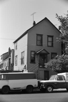
Manke's Cabins from Hastings Viaduct (900 Block E. Pender Street)
- COV-S305---: CVA 181-28
- Item
- [ca. 1965]
Part of City of Vancouver fonds
1519 results with digital objects Show results with digital objects
Manke's Cabins from Hastings Viaduct (900 Block E. Pender Street)
Part of City of Vancouver fonds
Russian Church at Georgia and Campbell
Part of City of Vancouver fonds

Part of City of Vancouver fonds
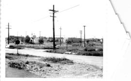
Looking north towards Georgia Viaduct from Union Street
Part of City of Vancouver fonds
![Area A-2 [Looking north-west. from 1000 Block Union Street]](/uploads/r/null/1/8/c/18c52e9c6ad49618ad4970e1d4e3577ab59b064154b43a899ad4a2e76673fbc7/741daa67-a4fa-4c43-9c8d-f215ae9de615-CVA181-32_142.jpg)
Area A-2 [Looking north-west. from 1000 Block Union Street]
Part of City of Vancouver fonds
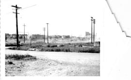
Looking south-west from Raymur Avenue
Part of City of Vancouver fonds

Looking south-west from Raymur Avenue
Part of City of Vancouver fonds

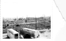
Area A-1, Relocation of Raymur Avenue
Part of City of Vancouver fonds

Sign on Union Street indicating Federal and Provincial and City support of Raymur Housing
Part of City of Vancouver fonds

McLean Park with 700 Block Keefer in background
Part of City of Vancouver fonds

City of Vancouver redevelopment : project 2, area A-2
Part of City of Vancouver fonds
Item is a map annotated with numbers, letters, and outlines on some properties in the Strathcona area. The significance of the annotations is unclear. Base map shows streets and legal addresses from Main Street to Clark Drive and the waterfront to Atlantic Street.

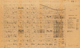
Plan of subdivision of block 120 (explanatory plan 8011), district lot 181
Part of City of Vancouver fonds
Item is a map annotated to show areas (in square feet and acres) of lots on the east side of the area cleared for development between Campbell Avenue, Raymur Avenue, Hastings Street, and Union Street. Base map is a subdivision plan for the area.

Plan of subdivision of block 120 (explanatory plan 8011), district lot 181
Part of City of Vancouver fonds
Item is a map annotated to show locations of hydro, telephone, water and gas services and sewers on the east side of the area cleared for development between Campbell Avenue, Raymur Avenue, Hastings Street, and Union Street. Base map is a subdivision plan for the area.
Part of City of Vancouver fonds
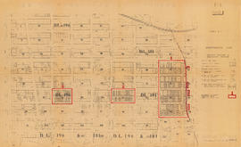
Item is a Planning Department map showing ownership of property included in the acquisition program. Base map is bounded by Main Street, Glen Drive, Alexander Street, and Atlantic Street, and shows streets, legal descriptions, schools, parks and Canadian Pacific and Canadian National railway lines.

Part of City of Vancouver fonds
Item is a map showing boundaries of clearance areas in Strathcona and ownership of property included in the acquisition program. Further annotations show the status of property acquisition and demolition. Base map is bounded by Main Street, Glen Drive, Alexander Street, and Atlantic Street, and shows streets, legal descriptions, schools, parks and Canadian Pacific and Canadian National railway lines.
Part of City of Vancouver fonds
Item is a map showing boundaries of clearance areas in Strathcona and ownership of property included in the acquisition program. Base map is bounded by Main Street, Glen Drive, Alexander Street, and Atlantic Street, and shows streets, legal descriptions, schools, parks and Canadian Pacific and Canadian National railway lines.
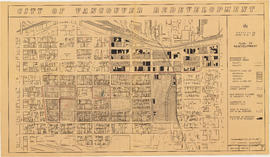
City of Vancouver redevelopment : project 1, area A-1 : City-owned land and buildings to be retained
Part of City of Vancouver fonds
Item is a map showing city-owned land, buildings in clearance areas to be retained, and boundaries of clearance areas. Base map shows streets, outlines of buildings, and topographic contour lines for the area from Main Street to Glen Drive and Alexander Street to Atlantic Street.

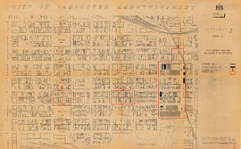
City of Vancouver redevelopment : project 1, area A-1 : detailed plan of redevelopment
Part of City of Vancouver fonds
Item is a map showing housing types, new streets and lanes, easements, and buildings to be retained as part of Project 1, and the boundaries of areas A1.1, A1.2, and A1.3. Base map shows streets, outlines of buildings, and topographic contour lines for the area from Main Street to Glen Drive and Alexander Street to Atlantic Street.

City of Vancouver redevelopment : project 1, area A-1.1 : existing and proposed utilities
Part of City of Vancouver fonds
Item is a map showing existing and proposed utilities for the area bounded by Campbell Avenue, Glen Drive, Cordova Street, and Union Street, and has been annotated to show which utilities are cost shareable under the Section 23 program.
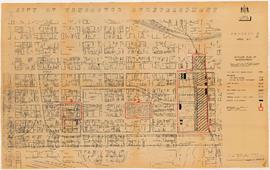
City of Vancouver redevelopment : project 1 : plan showing redevelopment of area A-1.1 as proposed
Part of City of Vancouver fonds
Item is a map showing building types, streets and lanes, easements, condition of buildings, property ownership, and revised clearance area boundaries in the area bounded by Campbell Avenue, Raymur Avenue, Powell Street, and Union Street.

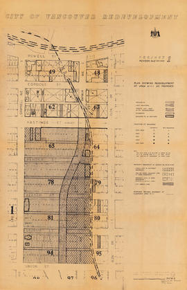
City of Vancouver redevelopment : project 2, part of area "A" : identification plan
Part of City of Vancouver fonds
Item is a map showing ownership of property included in the acquisition program, streets and lanes to be acquired and boundaries of project 1 and project 2 clearance areas in the area bounded by Main Street, Clark Drive, Alexander Street, and Atlantic Street.
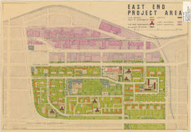
City of Vancouver redevelopment : project 2, area A-2 : plan of redevelopment
Part of City of Vancouver fonds
Item is a map showing boundaries of clearance areas, proposed land use and street system, new streets and lanes, easements, sites not to be acquired, and buildings to be retained in project 2. Some clearance boundaries are hand-coloured. Map covers the area bounded by Main Street, Clark Drive, Alexander Street, and Atlantic Street.

Strathcona rehabilitation program
Part of City of Vancouver fonds
Item is a map showing streets and building outlines in the area bounded by Main Street, Glen Drive, Hastings Street, and Malkin Avenue.
Part of City of Vancouver fonds
Item shows building types and proposed layout of buildings and streets in Strathcona as part of the 1957 Vancouver Redevelopment Study.

Part of City of Vancouver fonds
Part of City of Vancouver fonds

Part of City of Vancouver fonds
Part of City of Vancouver fonds

Part of City of Vancouver fonds

Part of City of Vancouver fonds

Part of City of Vancouver fonds

475 Alexander Street, Japanese Hall 1928
Part of City of Vancouver fonds
Part of City of Vancouver fonds

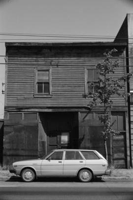
611 Alexander Street, American Can Co.
Part of City of Vancouver fonds
611 Alexander Street, American Can Co.
Part of City of Vancouver fonds

Part of City of Vancouver fonds
![636 Alexander Street [Heatley Machine Works Ltd.]](/uploads/r/null/4/d/6/4d6924002a3c5b268d61648606eb224206d6c1701573920cfb6f5bbbe05fccf4/52613555-6f13-42e7-b725-96025640daa5-CVA786-43_142.jpg)
636 Alexander Street [Heatley Machine Works Ltd.]
Part of City of Vancouver fonds

Part of City of Vancouver fonds

Part of City of Vancouver fonds
![American Can Company [611 Alexander Street]](/uploads/r/null/e/f/1/ef1562c749f7558b94b42cf36fb4a321aa67dfa21b4d99fbbe6abad377aed598/17cca64e-f6fa-4a1e-ab61-dc21d57e89e9-CVA786-43_142.jpg)
American Can Company [611 Alexander Street]
Part of City of Vancouver fonds
![Grain elevator [Centennial Road?]](/uploads/r/null/7/0/1/701f743ecf23ae4ef40a9ca217faef35dfeaaae79d44a98b4a68a2f197f12018/665b13c6-d114-48fb-a803-3a76c8d1b607-CVA786-43_142.jpg)
Grain elevator [Centennial Road?]
Part of City of Vancouver fonds
![Grain elevator [Centennial Road?]](/uploads/r/null/e/5/7/e577b94f3b6196172083e0d7e5cf72bfb7ffa9156a2a508f2216f7edce8d015a/91fb87a8-5d0f-4c4b-8607-7beada60b224-CVA786-44_142.jpg)
Grain elevator [Centennial Road?]
Part of City of Vancouver fonds

Part of City of Vancouver fonds

Part of City of Vancouver fonds
Part of City of Vancouver fonds

Part of City of Vancouver fonds

Part of City of Vancouver fonds

Part of City of Vancouver fonds