
Arts 20 Relay Race participants at U.B.C.
- AM1576-S6-12-F62-: 2011-010.1671
- Item
- Oct. 23, 1986
Arts 20 Relay Race participants at U.B.C.
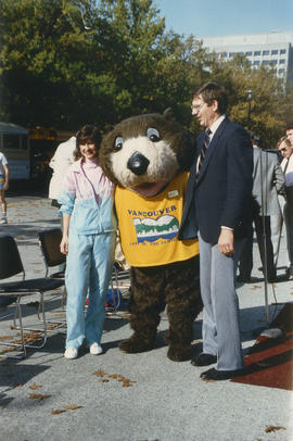
Tillicum posing with man and woman at the Arts 20 Relay Race

Plan of Point Grey Municipality
Part of City of Vancouver Archives technical and cartographic drawing collection
The map is a street map of the Municipality of Point Grey and parts of the City of Vancouver. It shows street car lines, district lot boundaries, postal block numbers and some street names

Plan of government subdivision at Point Grey, B.C.
Part of City of Vancouver Archives technical and cartographic drawing collection
Item is a sheet which has been excised from the Journal of the Town Planning Institute, December 1925 issue. The sheet consists of two street layout plans and an illustration. The street layout plans show current and proposed revised street layouts for the area of Point Grey bounded by Highbury Street, Eighth Avenue, Imperial Street, and Tenth Avenue. The illustration depicts the view north from the proposed development area.
![Plan of Point Grey Municipality [ward boundaries]](/uploads/r/null/a/c/a/aca691b3d6e49d092070fc230a88f5ca7bd346fc8c5894892d7cdc5a79b535ee/9a14b192-1858-43aa-ab28-d0b03a2304eb-MAP360_142.jpg)
Plan of Point Grey Municipality [ward boundaries]
Part of City of Vancouver Archives technical and cartographic drawing collection
Item is a copy of a commercially published map of Point Grey which has been used as a base map to depict existing and proposed new ward boundaries for Point Grey municipality.

Vancouver Harbour : Sheet 2 (Point Grey to Second Narrows)
Part of City of Vancouver Archives technical and cartographic drawing collection
item is a nautical chart of Burrard Inlet and Vancouver Harbour from Point Grey in the west to Second Narrows in the east, showing soundings in fathoms, tidal information, anchorages, beacons, and waterfront businesses. Street names are shown on land areas. A Royal Canadian Air Force bombing range at Jericho Beach is identified as a danger area.
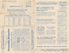
Municipality of Point Grey : sale of municipal-owned lands
Part of City of Vancouver Archives technical and cartographic drawing collection
Part contains text advertising properties in Point Grey and information on utilities, parks, schools, and property values in the municipality.

Sale of municipal lands : Point Grey : map showing location of lots to be sold
Part of City of Vancouver Archives technical and cartographic drawing collection

Lot numbers, boundaries, railway lines and street names in the municipality of Point Grey
Part of City of Vancouver Archives technical and cartographic drawing collection
Primary map shows lot numbers, boundaries, railway lines and street names in the municipality of Point Grey from 16th Avenue in the north to the Fraser River in the south and from Ontario Street in the east to Blanca Drive in the west. A smaller map in the bottom left-hand corner of the item shows the north west portion of Point Grey.

Point Grey, B.C. : district map
Part of City of Vancouver Archives technical and cartographic drawing collection
Item is a flyer or promotional brochure showing proposed zoning districts for the municipality of Point Grey to be created by a proposed zoning by-law. The districts are depicted on the map which makes up the majority of the item. Surrounding the map is the text of the proposed by-law.

Redevelopment plan for Jericho Department of National Defence lands
Part of City of Vancouver Archives technical and cartographic drawing collection
Item is a map showing proposed redevelopment of portions of former Department of National Defence lands in the Jericho area. The map shows existing city parks, D.N.D. lands to be taken over for parks and recreation, city owned land, single family land, town houses, garden apartments and town houses and proposed new roads. The map appears to have been removed from a report.
Vancouver (B.C.). Engineering Services

Vancouver, British Columbia : south-westerly portion, formerly Point Grey : major street plan
Part of City of Vancouver Archives technical and cartographic drawing collection
Item is a map which has been removed from a copy of the report "A plan for the City of Vancouver, British Columbia, including Point Grey and South Vancouver and a general plan of the region", commissioned by the Vancouver Town Planning Commission from the planning consultants Harland Bartholomew & Associates.
The map shows existing and proposed additions to the major street plan in part of the city that is the former Municipality of Point Grey. The map also shows present street widths, lines of vehicles and roadway widths versus proposed street widths, lines of vehicles and roadway widths.
Harland Bartholomew and Associates

Rezoning application map (Point Grey Road)
Part of City of Vancouver Archives technical and cartographic drawing collection
Item is a map that would have been created to accompany an application for re-zoning for Block 235 D.L. 538 and water lots 5834, 5601 and 5600. It appears that this application failed, as no amendment to By-law 3575 for these properties has been found.
Vancouver (B.C.). Planning Department

Plan of Point Grey Municipality
Part of City of Vancouver Archives technical and cartographic drawing collection
Item is map of the Municipality of Point Grey and parts of the City of Vancouver showing street car lines, district lot boundaries, postal block numbers and some street names. Map has been annotated with red dots in four locations, but the significance of the dots is unknown.

North Arm of the Fraser River : Ione Island sheet
Part of City of Vancouver Archives technical and cartographic drawing collection
Item is a copy of a geological survey map which has been used as a base map to denote the possible location of the home of Hugh McRoberts at the eastern end of Sea Island.

Part of City of Vancouver Archives technical and cartographic drawing collection
Item is a map showing major streets, lot numbers, lot boundaries and property sold or reserved in the area from Chaldecott Road (now King Edward Ave.) in the north to Magee Road (now W. 49th Ave.) in the south. Kaye Road (now Trafalgar St.), Wilson Road (now W. 41 Ave.), Bodwell Road (now W. 33rd Ave.) and Johnson Road (now Blenheim) are all included on the map.
Part of Karl Haspel fonds

Dolphin at Spanish Banks, Vancouver
Part of Karl Haspel fonds


![Morning under Point Grey [view of shoreline and downtown buildings in the distance]](/uploads/r/null/2/f/1/2f141748414f4696f19f2598cae139f425f9b807cbe7ce99510048b663ba66ea/9d927529-65a8-4ec4-b61a-2685d3a0aa70-CVA293-091_142.jpg)
Morning under Point Grey [view of shoreline and downtown buildings in the distance]
![Morning under Point Grey [view of shoreline and downtown buildings in the distance]](/uploads/r/null/a/c/c/accfb817ca5542dfee36ec72a3674496c03bd81838863832d1690e51f50befd7/23e750f8-09c6-4b8d-9169-4827db75ba88-CVA293-091_142.jpg)
Morning under Point Grey [view of shoreline and downtown buildings in the distance]
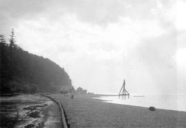
![Range on Wreck Beach [low tide]](/uploads/r/null/0/a/5/0a512f4f9485d1a83f1d55dba747ade57a8398a93d52ae2b8e93048c221d83bb/3c3104ef-6bc9-4afa-89ed-da2cfa1e705b-CVA293-165_142.jpg)
Range on Wreck Beach [low tide]
![Range on Wreck Beach [low tide]](/uploads/r/null/0/f/a/0fae513385181b90a03454bd0a046c92f57e42ba39f2d38800ee77bbfe6a01e8/4e54d145-5904-4aba-be67-2653decbedf8-CVA293-165_142.jpg)
Range on Wreck Beach [low tide]
![Jan. 26 2nds - Hangar #5 inside - Hangar #3 outside [1 of 17]](/uploads/r/null/6/d/e/6de25750308b13ded9faf176fb6089d8e61f533ea03b2329b6210930d30fb3e1/0320fab9-85cf-4c99-b94b-716e3c4e2068-2011-130_142.jpg)
Jan. 26 2nds - Hangar #5 inside - Hangar #3 outside [1 of 17]
Part of Habitat Forum photographs
Item is a photograph showing the view of Hangar 3 from Hangar 5, looking west.
![Jan. 26 2nds - Hangar #5 inside - Hangar #3 outside [2 of 17]](/uploads/r/null/8/6/e/86eae36412f791836aedf444b253da35a5a044d726b0a463bf4a897dadfcd533/7df587a7-da0d-4c52-8897-c686cb420e8d-2011-130_142.jpg)
Jan. 26 2nds - Hangar #5 inside - Hangar #3 outside [2 of 17]
Part of Habitat Forum photographs
Item is a photograph showing the interior of Hangar 5.
![Jan. 26 2nds - Hangar #5 inside - Hangar #3 outside [3 of 17]](/uploads/r/null/f/8/3/f835bfd3fb0e0592e5d9630dcb017478d20502ae4ccdc461621cf99cf3435e12/42500469-0cb1-4e31-8465-6674b16def51-2011-130_142.jpg)
Jan. 26 2nds - Hangar #5 inside - Hangar #3 outside [3 of 17]
Part of Habitat Forum photographs
Item is a photograph showing sawdust piles outside of Hangar 5.
![Jan. 26 2nds - Hangar #5 inside - Hangar #3 outside [4 of 17]](/uploads/r/null/f/1/9/f199eb387edbd6aa269cb63f06c6f8c9c899b3bdf1d665b2fe5d6c304c2430eb/ebdd507f-6b4f-456a-9de7-cf06e9ea7562-2011-130_142.jpg)
Jan. 26 2nds - Hangar #5 inside - Hangar #3 outside [4 of 17]
Part of Habitat Forum photographs
Item is a photograph showing Hangar 5 seating under construction.
![Jan. 26 2nds - Hangar #5 inside - Hangar #3 outside [5 of 17]](/uploads/r/null/f/e/b/feb7e12253edd076c88f8da2c06f9a8a7723e93fcfe0cbeab0a2b72faf2a67df/9e300640-53fc-40ae-b285-c5cc85030da0-2011-130_142.jpg)
Jan. 26 2nds - Hangar #5 inside - Hangar #3 outside [5 of 17]
Part of Habitat Forum photographs
Item is a photograph showing Hangar 5 seating under construction.
![Jan. 26 2nds - Hangar #5 inside - Hangar #3 outside [6 of 17]](/uploads/r/null/a/4/9/a4924f5b86fe841237a2ef501a208ea93a5dacea69ed9e33513b052838c07b0e/b27f19a2-6898-494c-affc-e56c42e21e7a-2011-130_142.jpg)
Jan. 26 2nds - Hangar #5 inside - Hangar #3 outside [6 of 17]
Part of Habitat Forum photographs
Item is a photograph showing the Hangar 5 entrance.
![Jan. 26 2nds - Hangar #5 inside - Hangar #3 outside [7 of 17]](/uploads/r/null/0/1/2/0128632b5dc10f7f9431fcac1a6d04c5f57ba2b15c5dc0e3c34dd26d5e8a2e70/7127689d-2eec-4364-b5b4-021e7eb27107-2011-130_142.jpg)
Jan. 26 2nds - Hangar #5 inside - Hangar #3 outside [7 of 17]
Part of Habitat Forum photographs
Item is a photograph showing the Hangar 5 under construction, portico underway.
![Jan. 26 2nds - Hangar #5 inside - Hangar #3 outside [8 of 17]](/uploads/r/null/3/6/7/367919f5844e9645bad483485e6a7f82a68d9447f5a80014e2b104721ed4edd4/35425adf-06d2-412c-bd96-850fdb72c857-2011-130_142.jpg)
Jan. 26 2nds - Hangar #5 inside - Hangar #3 outside [8 of 17]
Part of Habitat Forum photographs
Item is a photograph showing Doug Henry working on the covered walkway.
![Jan. 26 2nds - Hangar #5 inside - Hangar #3 outside [9 of 17]](/uploads/r/null/7/0/3/703070d787184af3fcfafcaaab70b0302b4c656c0ae79f7ff90f961b1d27e68c/00614f8a-12e1-48cd-beb3-519038445f61-2011-130_142.jpg)
Jan. 26 2nds - Hangar #5 inside - Hangar #3 outside [9 of 17]
Part of Habitat Forum photographs
Item is a photograph showing Doug Henry and John Knight working on the covered portico of Hangar 5.
![Jan. 26 2nds - Hangar #5 inside - Hangar #3 outside [10 of 17]](/uploads/r/null/3/f/1/3f195a83e358f5a767e00fe472019399aa376b710e62f52a81524cf839e2e977/8e401603-5873-4059-83b7-260508df2f89-2011-130_142.jpg)
Jan. 26 2nds - Hangar #5 inside - Hangar #3 outside [10 of 17]
Part of Habitat Forum photographs
Item is a photograph showing Michael Malcolm wearing a fur vest, working on the Hangar 5 portico.
![Jan. 26 2nds - Hangar #5 inside - Hangar #3 outside [11 of 17]](/uploads/r/null/2/f/5/2f59949bea6b7a15853a1aaf5731c568154fea32d6491e4343099500e100a931/0b9ec965-e278-438f-b20f-b6368d07ca2c-2011-130_142.jpg)
Jan. 26 2nds - Hangar #5 inside - Hangar #3 outside [11 of 17]
Part of Habitat Forum photographs
Item is a photograph showing the construction of the portico outside Hangar 5.
![Jan. 26 2nds - Hangar #5 inside - Hangar #3 outside [12 of 17]](/uploads/r/null/e/2/4/e249eb8cd05f23241647f5ad762d2ab2c2d838e1945a10d759deb9d665c3e537/b8bf9e38-aa4a-424c-a20b-a5a710577eaa-2011-130_142.jpg)
Jan. 26 2nds - Hangar #5 inside - Hangar #3 outside [12 of 17]
Part of Habitat Forum photographs
Item is a photograph showing the construction of the portico outside Hangar 5.
![Jan. 26 2nds - Hangar #5 inside - Hangar #3 outside [13 of 17]](/uploads/r/null/4/e/b/4eb02c6b2ad57eee6c03aa727cb24b9822888dcafe2ab34e3396e99f51a478eb/91687162-a492-4ba7-b957-09f877eb981c-2011-130_142.jpg)
Jan. 26 2nds - Hangar #5 inside - Hangar #3 outside [13 of 17]
Part of Habitat Forum photographs
Item is a photograph showing the construction of the portico outside Hangar 5.
![Jan. 26 2nds - Hangar #5 inside - Hangar #3 outside [14 of 17]](/uploads/r/null/4/c/e/4ce099ea07fbc08769f2b53e65bb7dd8025fa89df0b95fc8e10eea6e7905a8ec/c60cf745-4fea-4847-a8c9-b677db4a45da-2011-130_142.jpg)
Jan. 26 2nds - Hangar #5 inside - Hangar #3 outside [14 of 17]
Part of Habitat Forum photographs
Item is a photograph showing the construction of the portico outside Hangar 5.
![Jan. 26 2nds - Hangar #5 inside - Hangar #3 outside [15 of 17]](/uploads/r/null/2/b/0/2b05c0d4febd8d0ac8871e238c6776cae5f21adcf758cea9e66ae57d8533b3ec/bfa3b768-5c45-48f0-b75d-1a039dad25f9-2011-130_142.jpg)
Jan. 26 2nds - Hangar #5 inside - Hangar #3 outside [15 of 17]
Part of Habitat Forum photographs
Item is a photograph showing the Hangar 5 seating under construction.
![Jan. 26 2nds - Hangar #5 inside - Hangar #3 outside [16 of 17]](/uploads/r/null/0/f/b/0fb0f4a9b3e7b698889ed1927726c7530b38abb1f21ff301d133942939ab2efb/e9c4e876-926f-41c0-b1d4-535d2a119b83-2011-130_142.jpg)
Jan. 26 2nds - Hangar #5 inside - Hangar #3 outside [16 of 17]
Part of Habitat Forum photographs
Item is a photograph showing the Hangar 5 seating under construction.
![Jan. 26 2nds - Hangar #5 inside - Hangar #3 outside [17 of 17]](/uploads/r/null/3/5/7/357ca2f4a4f718d4f7ea086cbe5be21ce5d8083170cf9bb91e99450158acd8af/b0a9b66e-e4a8-4417-987d-ae5e936924b1-2011-130_142.jpg)
Jan. 26 2nds - Hangar #5 inside - Hangar #3 outside [17 of 17]
Part of Habitat Forum photographs
Item is a photograph showing a closet inside Hangar 5.
![Jan 2nd - Penalosa 2nds [1 of 21]](/uploads/r/null/b/b/6/bb681e461988945168f97efb1f65ef6fea13b5dddea00e1b6467029647aa19c2/5051e586-cf1a-4876-8ed8-2b3898933aa6-2011-130_142.jpg)
Jan 2nd - Penalosa 2nds [1 of 21]
Part of Habitat Forum photographs
Item is a photograph showing Enrique Peñalosa and group arriving for a tour of the Habitat Forum site.
![Jan 2nd - Penalosa 2nds [2 of 21]](/uploads/r/null/8/5/d/85d5bedca0218f29571e14a044cce492a860508dc032a5bd8de462b161919a4b/5b5e61f2-e139-47c0-b71c-d7d4a7ce2df4-2011-130_142.jpg)
Jan 2nd - Penalosa 2nds [2 of 21]
Part of Habitat Forum photographs
Item is a photograph showing Enrique Peñalosa and group touring the Habitat Forum site. Individials appearing in photograph include: Enrique Peñalosa, Al Clapp, Ron Basford, architect Mark Osburn and carpenter Doug Henry in the background.
![Jan 2nd - Penalosa 2nds [3 of 21]](/uploads/r/null/b/f/c/bfce0cd7215629b132a0893d35b0f1505a73b755d1cbbd1176c2be1a1e87484c/40f52cbd-6880-4e4a-ba09-82204b819ae8-2011-130_142.jpg)
Jan 2nd - Penalosa 2nds [3 of 21]
Part of Habitat Forum photographs
Item is a photograph showing Enrique Peñalosa and group touring the Habitat Forum site.
![Jan 2nd - Penalosa 2nds [4 of 21]](/uploads/r/null/d/c/4/dc4012475034ecfcc54e4875d726c53c7aaf9d8ef7b3e08071c3dbacb0ddcb31/1b0d58ce-94c3-40a4-a833-e0ba9332ade0-2011-130_142.jpg)
Jan 2nd - Penalosa 2nds [4 of 21]
Part of Habitat Forum photographs
Item is a photograph showing Enrique Peñalosa, Father George Muhoho and group touring the Habitat Forum site.
![Jan 2nd - Penalosa 2nds [5 of 21]](/uploads/r/null/b/f/f/bffa70dd3690290bf6351706e05c70b99951531b7b02b63cd535fe7fcda94d17/c662e7dc-c56c-4147-b23e-d320e9ccd984-2011-130_142.jpg)
Jan 2nd - Penalosa 2nds [5 of 21]
Part of Habitat Forum photographs
Item is a photograph showing (L-R) Enrique Peñalosa, Ron Basford, George Muhoho and Walter Hardwick during a tour of the Habitat Forum site.
![Jan 2nd - Penalosa 2nds [6 of 21]](/uploads/r/null/6/b/e/6bed958f1c40a46a59e185a42d17a274ed21d7ea9b6028eac65158d78dd4d1fb/26a1bc36-7eb3-49fb-97eb-fb4e8bf35a93-2011-130_142.jpg)
Jan 2nd - Penalosa 2nds [6 of 21]
Part of Habitat Forum photographs
Item is a photograph showing Enrique Peñalosa and Ron Basford touring the Habitat Forum site.
![Jan 2nd - Penalosa 2nds [7 of 21]](/uploads/r/null/0/d/a/0da23babe0589522d5bda91a105eae12b1667ae266f71a826463adb54c5b0de3/4bc38c60-4ba8-46dd-976c-92b0daf933f6-2011-130_142.jpg)
Jan 2nd - Penalosa 2nds [7 of 21]
Part of Habitat Forum photographs
Item is a photograph showing Enrique Peñalosa and Father George Muhoho touring the Habitat Forum site.
![Jan 2nd - Penalosa 2nds [8 of 21]](/uploads/r/null/0/b/c/0bc6e08275e72dedcdd82d4655baa4842c2f4faeadaa822bae458e57f42b03a8/5b4499f5-a165-4013-86ff-96018f06107b-2011-130_142.jpg)
Jan 2nd - Penalosa 2nds [8 of 21]
Part of Habitat Forum photographs
Item is a photograph showing Enrique Peñalosa and Ron Basford touring the Habitat Forum site.
![Jan 2nd - Penalosa 2nds [9 of 21]](/uploads/r/null/a/2/9/a29158d966059de22762eee21803be75513c8643da83c288c802de18874cac58/3b28ee25-74d3-4cff-9f0d-b28a3120e1f2-2011-130_142.jpg)
Jan 2nd - Penalosa 2nds [9 of 21]
Part of Habitat Forum photographs
Item is a photograph showing Enrique Peñalosa and Father George Muhoho touring the Habitat Forum site.