CKNW interview with City planners [part 1]
- COV-S138-: LEG1214.18-: LEG1214.18.1
- Part
- July 9, 1991
Part of City of Vancouver fonds
435 results with digital objects Show results with digital objects
CKNW interview with City planners [part 1]
Part of City of Vancouver fonds
CKNW interview with City planners [part 2]
Part of City of Vancouver fonds

Part of City of Vancouver fonds
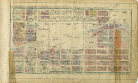
Part is a section depicting the area bounded by Boundary Road to Burrard Inlet to Slocan Street to Triumph Street. The sheet has been extensively annotated, with colour coded areas to depict land use, status of lots as tax sale properties for sale, sewer and water lines, as well as other colour codes that are not noted on the legend at the front of the volume.

Vancouver section 2 supplementary information
Part of City of Vancouver fonds
Part is a sheet showing information noted about assessments and other information relevant to Vancouver section 2.

Part of City of Vancouver fonds
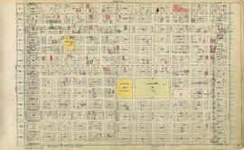
Part is a section depicting the area bounded by Boundary Road to Triumph Street to Slocan Street to Charles Street. The sheet has been extensively annotated, with colour coded areas to depict land use, status of lots as tax sale properties for sale, sewer and water lines, as well as other colour codes that are not noted on the legend at the front of the volume.

Vancouver section 3 supplementary information
Part of City of Vancouver fonds
Part is a sheet showing information noted about assessments and other information relevant to Vancouver section 3.

Part of City of Vancouver fonds
Part is a section depicting the area bounded by Boundary Road to Charles Street to Slocan Street to Seventh Avenue. The sheet has been extensively annotated, with colour coded areas to depict land use, status of lots as tax sale properties for sale, sewer and water lines, as well as other colour codes that are not noted on the legend at the front of the volume.
Vancouver section 4 supplementary information
Part of City of Vancouver fonds
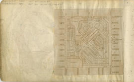
Part is a sheet showing information noted about assessments and other information relevant to Vancouver section 4. The sheet also includes a small map of the redevelopment of the are bounded by Boundary Road to 13th Avenue to Rupert Street to 22nd Avenue.
Part of City of Vancouver fonds
Part is a section depicting the area bounded by Boundary Road to Seventh Avenue to Slocan Street to Seventeenth Avenue.

Vancouver section 5 supplementary information
Part of City of Vancouver fonds
Part is a sheet showing information noted about assessments and other information relevant to Vancouver section 5.

Part of City of Vancouver fonds
Part is a section depicting the area bounded by Boundary Road to Seventeenth Avenue to Slocan Street to Twenty-ninth Avenue. The sheet has been extensively annotated, with colour coded areas to depict land use, status of lots as tax sale properties for sale, sewer and water lines, as well as other colour codes that are not noted on the legend at the front of the volume.

Vancouver section 6 supplementary information
Part of City of Vancouver fonds
Part is a sheet showing information noted about assessments and other information relevant to Vancouver section 6.

Part of City of Vancouver fonds
Part is a section depicting the area bounded by Slocan Street to Eighteenth Avenue to Knight Street to Twenty-ninth Avenue. The sheet has been extensively annotated, with colour coded areas to depict land use, status of lots as tax sale properties for sale, sewer and water lines, as well as other colour codes that are not noted on the legend at the front of the volume.

Vancouver section 7 supplementary information
Part of City of Vancouver fonds
Part is a sheet showing information noted about assessments and other information relevant to Vancouver section 7.

Part of City of Vancouver fonds
Part is a section depicting the area bounded by Slocan Street to Seventh Avenue to Clark Drive to Eighteenth Avenue. The sheet has been extensively annotated, with colour coded areas to depict land use, status of lots as tax sale properties for sale, sewer and water lines, as well as other colour codes that are not noted on the legend at the front of the volume.

Vancouver section 8 supplementary information
Part of City of Vancouver fonds
Part is a sheet showing information noted about assessments and other information relevant to Vancouver section 8.

Part of City of Vancouver fonds
Part is a section depicting the area bounded by Slocan Street to William Street to Clark Drive to Seventh Avenue. The sheet has been extensively annotated, with colour coded areas to depict land use, status of lots as tax sale properties for sale, sewer and water lines, as well as other colour codes that are not noted on the legend at the front of the volume.

Vancouver section 9 supplementary information
Part of City of Vancouver fonds
Part is a sheet showing information noted about assessments and other information relevant to Vancouver section 9.

Part of City of Vancouver fonds
Part is a section depicting the area bounded by Slocan Street to Triumph Street to Clark Drive to William Street. The sheet has been extensively annotated, with colour coded areas to depict land use, status of lots as tax sale properties for sale, sewer and water lines, as well as other colour codes that are not noted on the legend at the front of the volume.

Vancouver section 10 supplementary information
Part of City of Vancouver fonds
Part is a sheet showing information noted about assessments and other information relevant to Vancouver section 10.

Part of City of Vancouver fonds
Part is a section depicting the area bounded by Slocan Street to Burrard Inlet to Clark Drive end to Triumph Street. The sheet has been extensively annotated, with colour coded areas to depict land use, status of lots as tax sale properties for sale, sewer and water lines, as well as other colour codes that are not noted on the legend at the front of the volume.

Vancouver section 11 supplementary information
Part of City of Vancouver fonds
Part is a sheet showing information noted about assessments and other information relevant to Vancouver section 11.

Part of City of Vancouver fonds
Part is a section depicting the area bounded by Clark Drive to Burrard Inlet to Carrall Street to Keefer Street. The sheet has been extensively annotated, with colour coded areas to depict land use, status of lots as tax sale properties for sale, sewer and water lines, as well as other colour codes that are not noted on the legend at the front of the volume.
Vancouver section 12 supplementary information
Part of City of Vancouver fonds
Part is a sheet showing information noted about assessments and other information relevant to Vancouver section 12.

Part of City of Vancouver fonds
Part is a sheet depicting the area bounded by Clark Drive to Keefer Street to Ontario Street to Third Avenue. The sheet has been extensively annotated, with colour coded areas to depict land use, status of lots as tax sale properties for sale, sewer and water lines, as well as other colour codes that are not noted on the legend at the front of the volume.

Vancouver section 13 supplementary information
Part of City of Vancouver fonds
Part is a sheet showing information noted about assessments and other information relevant to Vancouver section 13.

Part of City of Vancouver fonds
Part is a section depicting the area bounded by Clark Drive to Fourth Avenue to Ontario Street to Sixteenth Avenue. The sheet has been extensively annotated, with colour coded areas to depict land use, status of lots as tax sale properties for sale, sewer and water lines, as well as other colour codes that are not noted on the legend at the front of the volume.

Vancouver section 14 supplementary information
Part of City of Vancouver fonds
Part is a sheet showing information noted about assessments and other information relevant to Vancouver section 14.

Part of City of Vancouver fonds
Part is a section depicting the area bounded by Knight Street to Fifteenth Avenue to Main Street to King Edward Avenue. The sheet has been extensively annotated, with colour coded areas to depict land use, status of lots as tax sale properties for sale, sewer and water lines, as well as other colour codes that are not noted on the legend at the front of the volume.

Vancouver section 15 supplementary information
Part of City of Vancouver fonds
Part is a sheet showing information noted about assessments and other information relevant to Vancouver section 15.

Part of City of Vancouver fonds
Part is a section depicting the area bounded by Howard Street to Fourth Avenue to Oak Street to Sixteenth Avenue. The sheet has been extensively annotated, with colour coded areas to depict land use, status of lots as tax sale properties for sale, sewer and water lines, as well as other colour codes that are not noted on the legend at the front of the volume.

Vancouver section 16 supplementary information
Part of City of Vancouver fonds
Part is a sheet showing information noted about assessments and other information relevant to Vancouver section 16.

Part of City of Vancouver fonds
Part is a section depicting the area bounded by Oak Street to Fourth Avenue to Maple Street to Sixteenth Avenue. The sheet has been extensively annotated, with colour coded areas to depict land use, status of lots as tax sale properties for sale, sewer and water lines, as well as other colour codes that are not noted on the legend at the front of the volume.

Vancouver section 17 supplementary information
Part of City of Vancouver fonds
Part is a sheet showing information noted about assessments and other information relevant to Vancouver section 17.
Part of City of Vancouver fonds
Part is a section depicting the area bounded by Maple Street to Third Avenue to Trutch Street to Sixteenth Avenue. The sheet has been extensively annotated, with colour coded areas to depict land use, status of lots as tax sale properties for sale, sewer and water lines, as well as other colour codes that are not noted on the legend at the front of the volume.

Part of City of Vancouver fonds
Part is a section depicting the area bounded by Maple Street to English Bay to Trutch Street to Third Avenue. The sheet has been extensively annotated, with colour coded areas to depict land use, status of lots as tax sale properties for sale, sewer and water lines, as well as other colour codes that are not noted on the legend at the front of the volume.

Vancouver section 19 supplementary information
Part of City of Vancouver fonds
Part is a sheet showing information noted about assessments and colour coding relevant to Vancouver section 19.

Part of City of Vancouver fonds
Part is a section depicting: the area of the West End south-west of Pacific Street between Bute Street and the CP railyards; Granville Island; and the area of Kitsilano north of Third Avenue and east of Maple Street. The sheet has been extensively annotated, with colour coded areas to depict land use, status of lots as tax sale properties for sale, sewer and water lines, as well as other colour codes that are not noted on the legend at the front of the volume.

Vancouver section 20 supplementary information
Part of City of Vancouver fonds
Part is a sheet showing information relevant to Vancouver section 20.

Part of City of Vancouver fonds
Part is a section depicting: the area of Yaletown south of Robson Street and east of Granville Street to False Creek; and the area bounded by Ontario Street to False Creek to Ash Street to Sixth Avenue. The sheet has been extensively annotated, with colour coded areas to depict land use, status of lots as tax sale properties for sale, sewer and water lines, as well as other colour codes that are not noted on the legend at the front of the volume.

Vancouver section 21 supplementary information
Part of City of Vancouver fonds
Part is a sheet showing information relevant to Vancouver section 21.

Part of City of Vancouver fonds
Part is a section depicting the area bounded by Columbia Street to Burrard Inlet to Burrard Street to Robson Street. The sheet has been extensively annotated, with colour coded areas to depict land use, status of lots as tax sale properties for sale, sewer and water lines, as well as other colour codes that are not noted on the legend at the front of the volume.

Vancouver section 22 supplementary information
Part of City of Vancouver fonds
Part is a sheet showing information relevant to Vancouver section 22.

Part of City of Vancouver fonds
Part is a section depicting the area bounded by Burrard Street to Coal Harbour to Stanley Park/Lost Lagoon to Robson Street. The sheet has been extensively annotated, with colour coded areas to depict land use, status of lots as tax sale properties for sale, sewer and water lines, as well as other colour codes that are not noted on the legend at the front of the volume.

Vancouver section 23 supplementary information
Part of City of Vancouver fonds
Part is a sheet showing assessment and other information relevant to Vancouver section 22.

Part of City of Vancouver fonds
Part is a section depicting the area bounded by Granville Street to Robson Street to Stanley Park to English Bay/False Creek. The sheet has been extensively annotated, with colour coded areas to depict land use, status of lots as tax sale properties for sale, sewer and water lines, as well as other colour codes that are not noted on the legend at the front of the volume.

Point Grey section A supplementary information
Part of City of Vancouver fonds
Part is a sheet showing assessment and other information relevant to Point Grey section A.

Part of City of Vancouver fonds
Part is a section depicting the area bounded by Imperial Street to English Bay to the University Endowment Lands to Fifth Avenue. The sheet has been extensively annotated, with colour coded areas to depict land use, status of lots as tax sale properties for sale, sewer and water lines, as well as other colour codes that are not noted on the legend at the front of the volume.

Point Grey section B supplementary information
Part of City of Vancouver fonds
Part is a sheet showing assessment and other information relevant to Point Grey section B.

Part of City of Vancouver fonds
Part is a section depicting the area bounded by Trutch Street to English Bay to Imperial Street to Fifth Avenue. The sheet has been extensively annotated, with colour coded areas to depict land use, status of lots as tax sale properties for sale, sewer and water lines, as well as other colour codes that are not noted on the legend at the front of the volume.