Map and views of Vancouver, British Columbia, Canada

Visit the souvenir shop

Hotels

District lot index and street index (1st Avenue to Campbell Avenue)

Street index (Campbell Street to Rosser Avenue)

Street index (Royal Oak Avenue, Vancouver to Frederick Road, North Vancouver)

What the man who comes to Vancouver wants to know

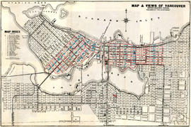
Street map of Greater Vancouver : map cover, street index and advertisements

Map and views of the terminal city, Vancouver, British Columbia, Canada : map cover
![Vancouver, B.C., the Pacific coast terminus of the C.P.R. [Canadian Pacific Railway]](/uploads/r/null/e/2/c/e2cdc004f3cf462100ed2ef053aa6087887b3f3200917cd5fba6292afb3b2d2d/bfcde3fa-32d7-4d08-86e5-ecf70c6f8388-LEG1340_142.jpg)
Vancouver, B.C., the Pacific coast terminus of the C.P.R. [Canadian Pacific Railway]

A souvenir and correct map of the location of all the fair buildings of the Vancouver Exhibition
![Vancouver, B.C., the Pacific coast terminus of the C.P.R. [Canadian Pacific Railway]](/uploads/r/null/8/3/f/83fcf65f0d66d64e6357d0d647e0ea6e2fa4aae4c3d1919f952d7725b4299cda/623e750c-fbab-43b7-a496-d20b384baeb6-LEG1321_142.jpg)
Vancouver, B.C., the Pacific coast terminus of the C.P.R. [Canadian Pacific Railway]
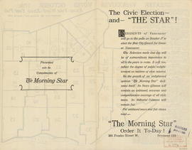
The civic election - and "The Star"!

The civic election - and "The Star"!

Advertisements for Vancouver real estate

Indexed map of Greater Vancouver : map cover and advertisements

Free map of Vancouver, New Westminster and surroundings

Map and Guide to Vancouver Street Car and Interurban Lines

City of Vancouver : residential lots, Area B, Champlain Heights : page 1

City of Vancouver : residential lots, Area B, Champlain Heights : page 2

Vancouver, B.C. : Canada's evergreen playground : city map and points of interest of Vancouver, British Columbia : tourist information

Vancouver Parks and Recreation : a guide to services

Vancouver Parks and Recreation : a guide to services
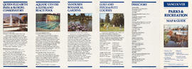
Vancouver Parks and Recreation : map and guide

Map of Vancouver, British Columbia : street index

Map cover
Information on transit and buildings in Vancouver

Street index to new city map

Street index of Vancouver and Lower Mainland

A student to-day, a citizen tomorrow

Vancouver - the third largest city of the dominion, and Canada's chief Pacific port

Plan of the City of Vancouver
![Age of buildings : Slocan Street to Boundary Road and Wall Street/East Street [Edinburgh Street] ...](/uploads/r/null/e/9/2/e921e2151aed2f9a2fd506bbc7e781632de17633f5f2f1a410764a15e68501b4/01454f17-8dfb-417d-9fd9-0093f19fcd56-LEG1221_142.jpg)
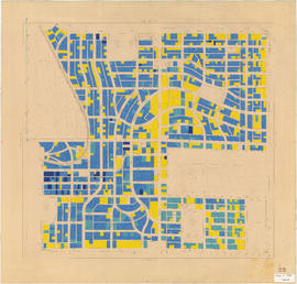
Age of buildings : Slocan Street to Boundary Road and Wall Street/East Street [Edinburgh Street] to Pender Street
Age of buildings : Knight Street to Elliott Street and 53rd Avenue to Kent Avenue
Age of buildings : Knight Street to Wales Street/Vivian Street and 37th Avenue to 53rd Avenue

Age of buildings : Nanaimo Street to Jellicoe Street and S.E. Marine Drive to Kent Avenue

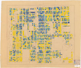
Age of buildings : Main Street to Clark Drive and Prior Street/Venables Street to Broadway

Age of buildings : Jellicoe Street to Boundary Road and S.E. Marine Drive to Kent Avenue

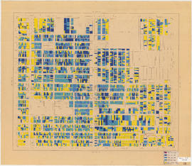
Age of buildings : Main Street to Knight Street and King Edward Avenue to 41st Avenue
Age of buildings : Quebec Street to Knight Street and 41st Avenue to 57th Avenue

Age of buildings : Main Street to Clark Drive/Knight Street and Broadway to King Edward Avenue

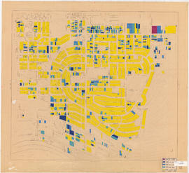
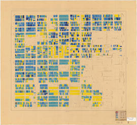
1954 : Age of buildings : Maps 20 and 21 : Downtown and West End

Age of buildings : Main Street to Knight Street and 57th Avenue to Kent Avenue
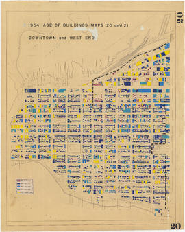
1954 : Age of buildings : Maps 20 and 21 : Downtown and West End
Age of buildings : Slocan Street to Boundary Road and Pender Street to 5th Avenue

Age of buildings : Oak Street to Main Street and Broadway to King Edward Avenue

Age of buildings : Oak Street to Quebec Street and 41st Avenue to 57th Avenue

Age of buildings : Fremlin Street to Main Street and 57th Avenue to Kent Avenue

Age of buildings : Arbutus Street to Oak Street and Odgen Avenue to Broadway
Age of buildings : Arbutus Street to Oak Street and King Edward Avenue to 41st Avenue