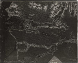
Fraser River and Burrard Inlet
- AM1594-: MAP 785
- Item
- Nov. 30, 1860, with revisions and corrections to May 21, 1926
Part of City of Vancouver Archives technical and cartographic drawing collection
9 results with digital objects Show results with digital objects
Fraser River and Burrard Inlet
Part of City of Vancouver Archives technical and cartographic drawing collection

Part of City of Vancouver Archives technical and cartographic drawing collection
Item is a sheet with three nautical charts. The main chart depicts Burrard Inlet from Atkinson Point [Point Atkinson] in the west to the "townsite of Port Moody" in the east. The inset charts depict Vancouver Harbour and the Second Narrows.
Part of City of Vancouver Archives technical and cartographic drawing collection
Item is a nautical chart depicting Burrard Inlet, including English Bay, Vancouver Harbour, False Creek, Second Narrows, the North Arm of Burrard Inlet and Port Moody. Soudings are given in fathoms.

Vancouver Island and adjacent shores of British Columbia
Part of City of Vancouver Archives technical and cartographic drawing collection

Haro Strait and middle channel
Part of City of Vancouver Archives technical and cartographic drawing collection
Item is a reproduction of a nautical chart of Haro Strait and middle channel between Vancouver Island and the mainland.

Fraser River and Burrard Inlet
Part of Major Matthews collection

Fraser River and Burrard Inlet
Part of Major Matthews collection
Fraser River and Burrard Inlet
Part of Major Matthews collection
Fraser River and Burrard Inlet
Part of Major Matthews collection

Cape Caution to Port Simpson including Hecate Strait and part of Queen Charlotte Islands
Part of City of Vancouver Archives technical and cartographic drawing collection
Part of City of Vancouver Archives technical and cartographic drawing collection
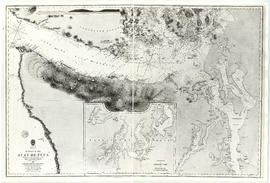
Item is a reproduction of a map of the Strait of Juan de Fuca, including the southern tip of Vancouver Island, the southern Gulf Islands and adjacent mainland, Admiralty Inlet and Puget Sound.

Part of Major Matthews collection
Item is a nautical chart of the seas surrounding Campobello Island, New Brunswick and surrounding islands.