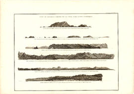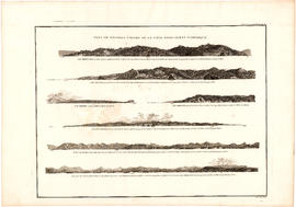
Vue de diverses parties de la côte nord-ouest d'Amérique
- AM1594-: MAP 1156
- Item
- [1800?]
Part of City of Vancouver Archives technical and cartographic drawing collection
Item is a graphical plate from an atlas, showing views of Cape Mendocino, Cape Orford, Grenville Point, the entrance to the Straits of Juan de Fuca and the coastline south of Cape Flattery. The item is a plate from a French reprinting of "A Voyage of Discovery to the North Pacific Ocean and round the world..." by George Vancouver.