Sectional plan of Vancouver [zoning and land use]
- COV-S167---: LEG1153.456
- Item
- [ca. 1936-ca. 1950]
Part of City of Vancouver fonds
58 results with digital objects Show results with digital objects
Sectional plan of Vancouver [zoning and land use]
Part of City of Vancouver fonds

Proposed industrial subdivision - Joyce and Vanness
Part of City of Vancouver fonds
Map of Vancouver, British Columbia
Part of City of Vancouver Archives technical and cartographic drawing collection
Map shows city streets, residential, apartment, commercial and industrial districts, "city owned parks and proposed driveways".
Plot plan : Sicks' proposed Capilano Stadium at Vancouver, B.C.
Part of City of Vancouver Archives technical and cartographic drawing collection
Item is a drawing with three site plans showing three possible locations for a proposed Capilano Stadium either in or adjacent to Riley Park. The sheet also includes an elevation of the C.P.R. land adjacent to Riley Park.
Sick's Breweries Ltd. (Vancouver, B.C.)
Commercial Map of Greater Vancouver and District [BC]
Part of City of Vancouver Archives technical and cartographic drawing collection
The map shows the Greater Vancouver Area and its roads, streets, and residential, commercial, and industrial districts in July 1924. In accordance with the legend, the map shows railroads, electric railways, parks, and buildings. The map uniquely depicts the center of Vancouver which is approximately 5400 feet and spans from Water and Railway Street to Prior Street and Abbott Street to Princess Street. The center circle then concentrically expands outwards with other circles marking every mile outward.
Additionally, there are annotations in black, red, yellow, and green. The black annotations mark topography and contour lines with listed elevations. The red annotations mark water gauges. The yellow annotations indicate the best routes through the City and District as suggested by the Automobile Club of BC. The green annotations appear for an unknown reason.
The Westernmost road on the map is Marine Drive and the Easternmost is Columbia Street and North Road while the Northernmost road on the map is Dempsey St. in North Vancouver and the Southernmost point is No. 20 Road.
Map of Vancouver Unemployment and Relief [BC]
Part of City of Vancouver Archives technical and cartographic drawing collection
The map shows relief and elevations of Vancouver. It depicts streets, parks, and railways, and residential and industrial areas.
The annotations in black ink trace parts of the map: names, railways, and the coast line. The amendments also show Cases and Persons of Domiciled Residents in the Vancouver Area, in May 1934. The map also lists statistics of approximate Cases and Persons of Transient Families and Single Women, and Single Homeless Men.
Pensions and Compensation statistics are also compiled for: Mothers Pensions, Old Age Pensions, War Pensions, amd Workmen's Compensation as of the population of Vancouver in 1931.
The westernmost boundary of the map is Boundary Road and the easternmost boundary is the University of British Columbia while the northernmost is the Burrard Inlet and the southernmost is Sea Island and Lulu Island.

Redevelopment plan for Jericho Department of National Defence lands
Part of City of Vancouver Archives technical and cartographic drawing collection
Item is a map showing proposed redevelopment of portions of former Department of National Defence lands in the Jericho area. The map shows existing city parks, D.N.D. lands to be taken over for parks and recreation, city owned land, single family land, town houses, garden apartments and town houses and proposed new roads. The map appears to have been removed from a report.
Vancouver (B.C.). Engineering Services
The Westcoast building newsletter, Volume 1, No. 1
Metropolitan Vancouver: an overview for social planners
Land development and taxation in a central commercial zone, Vancouver
Inner city neighbourhood rejuvenation : local transit as a catalyst for infill redevelopment

Part of City of Vancouver fonds
Item is a map created to depict utilities in the proposed project 2 area 6. The map shows fire alarms, sewer lines, water lines, gas lines, underground telephone lines, underground power lines, underground vaults, and curbs. Also noted are existing buildings which may be cleared in future projects, existing buildings in immediate vicinity of area a-6 which may remain, existing subdivisions to be cancelled, easement boundaries, approximate elevations at street intersections, approximate locations at contours and areas for disposal ("private development" and "public housing").

Part of area "a" : plan of redevelopment, Strathcona
Part of City of Vancouver fonds
Item is a map showing the boundaries of project 1, project 2 and scheme 3, the proposed land use, the propsed ultimate street system, the new streets and lanes in projects 1 and 2, the easements in projects 1 and 2, the sites in project 2 not to be acquired, the buildings in projects 1 and 2 to be retained and the area a-6 (north) in the area from Railway Street in the north to Atlantic Street in the south and from Clark Drive in the east to Main Street in the west.

Redevelopment Project No. 2 Plan No. 1
Part of City of Vancouver fonds
Item is an index plan showing the various area sub-projects for redevelopment project no. 2, and designates comprehensive vs. limited re-development areas. Area A-6 is highlighted in red.

Project 2, part of area "a" : identification plan
Part of City of Vancouver fonds
Item is a map showing city owned property, adjacent lots in same ownership, non-adjacent lots in same ownership, property to be acquired, streets and lanes to be acquired, the boundaries for project 2 clearance, the boundaries for project 1 clearance and the realignment of Raymur Ave for the area from Railway Street in the north to Atlantic Street in the south and from Clarke Drive in the east to Main Street in the west.
Attached label indicates that the map was approved by Council Sept. 17, 1963.

Project 2, part of area "a" : utility diversions and rearrangements
Part of City of Vancouver fonds
Item is a map showing boundaries of clearance areas for project 2 (areas 5 (part), 6 and 7) and project 1 (area 3). Maps also show sewers to remain, sewers to be abandoned, water lines to remain, water lines to be abandoned, gas lines to remain, gas lines to be abandoned, power lines existing underground, proposed diversions of power lines, power lines existing overhead, proposed overhead power lines and long distance telephone lines existing underground. Larger map shows area from Hastings Street in the north to Union Street in the south and from Heatley Avenue in the east to Gore Avenue in the west. Smaller map shows area from Powell Street in the north to Hastings Street in the south and from Clark Drive in the east to Glen Drive in the west. Item also shows estimates of costs for utility diversions and rearrangements for areas 5, 6 and 7.
Attached label indicates that the map was approved by Council Sept. 17, 1963.

Project 2, part of area "a" : plan of redevelopment
Part of City of Vancouver fonds
Item is a map showing the boundaries of clearance areas for projects 1 and 2, the proposed land use (residential, commercial, industrial or school and park sites), the proposed ultimate street system, the new streets and lanes in projects 1 and 2, the easements in projects 1 and 2, the sites in project 2 not to be acquired and the buildings in projects 1 and 2 to be retained in the area from Burrard Inlet in the north to Atlantic Street in the south and from Clark Drive in the east to Main Street in the west.
Attached label indicates that the map was approved by Council Sept. 17, 1963.

Project 2, part of area "a" : existing utilities, gas, electricity and telephone
Part of City of Vancouver fonds
Item is a map showing the gas lines, the overhead and underground electricity lines, the overhead and underground telephone lines, the fire alarms underground, the boundaries of project 2 clearance, the boundaries of project 1 clearance and the realignment of Raymur Avenue in the area from Railway Street in the north to Atlantic Street in the south and from Clark Drive in the east to Main Street in the west.
Attached label indicates that the map was approved by Council Sept. 17, 1963.

Project 2, part of area "a" : existing utilities, water and sewer
Part of City of Vancouver fonds
Item is a map showing the water pipes (10" and over), the sewers (15" and over), the direction of sewer flow, the boundaries of project 2 clearance, the boundaries of project 1 clearance and the realignment of Raymur Avenue in the area from Burrard Inlet in the north to Atlantic Street in the south and from Clark Drive in the east to Main Street in the west.
Attached label indicates that the map was approved by Council Sept. 17, 1963.

Project 2, part of area "a" : pavements, curbs and sidewalks
Part of City of Vancouver fonds
Item is a map showing the types of pavement, the curbs and gutters, the sidewalks, the boundaries of project 2 clearance, the boundaries of project 1 clearance and the realignment of Raymur Avenue from Railway Street in the north to Atlantic Street in the south and from Clark Drive in the east to Main Street in the west.
Attached label indicates that the map was approved by Council Sept. 17, 1963.

Project 2, part of area "a" : condition of buildings
Part of City of Vancouver fonds
Item is a map showing the condition of buildings (ranging from very good to very poor), the boundaries of project 2 clearance, the boundaries of project 1 clearance and the realignment of Raymur Avenue in the area from Burrard Inlet in the north to Atlantic Street in the south and from Clark Drive in the east to Main Street in the west.
Attached label indicates that the map was approved by Council Sept. 17, 1963.

Project 2, part of area "a" : aerial photograph
Part of City of Vancouver fonds
Item is a map in the form of an aerial photograph, which depicting the part of the city covered by the project: from Railway Street in the north to Prior Street in the south and from Clark Drive in the east to Main Street in the west.
Attached label indicates that the map was approved by Council Sept. 17, 1963.

Project 2 : generalized plan of redevelopment
Part of City of Vancouver fonds
Item is a map showing the boundaries of redevelopment areas ("comprehensive" and "limited"), the boundaries of clearance areas for project 1, the boundaries of clearance areas for project 2, the proposed street system and the proposed land use for the city of Vancouver from Burrard Inlet in the north to 16th Avenue in the south and from Nanaimo Street in the east to Arbutus Street in the west.
Attached label indicates that the map was approved by Council Sept. 17, 1963.
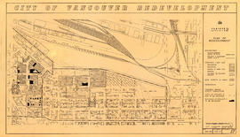
Part of City of Vancouver fonds
Map is a plan for redevelopment project 2, Area A-2, showing the area bound by Clark Drive, Atlantic Street, Main Street and the waterfront. Annotations are undated pencil notations over some of the blocks.

Project 2, area "h" and part of "b" : proposed property acquisitions project 2
Part of City of Vancouver fonds
Item is a map showing boundaries of project in area a, property to be acquired, proposed street widening and city owned property included. Annotations show boundaries of project areas, property too be acquired, proposed street widening and properties already owned by the City. Map has been noted as Preliminary.

Project 2, area a-2 : proposed property acquisitions project 2
Part of City of Vancouver fonds
Item is a map showing boundaries of project in area a, property to be acquired, proposed street widening and city owned property included. Annotations show boundaries of project areas, property too be acquired, proposed street widening and properties already owned by the City. Map has been noted as Preliminary.
Project 2, area "h" and part of "b" : plan of redevelopment
Part of City of Vancouver fonds
Item is a map showing the boundaries of redevelopment areas "b" and "h", the boundaries of project 2 clearance areas 8 and 9, proposed land use, new streets and lanes, easements, sites in project 2 not to be acquired and buildings in project 2 to be retained in the area from Terminal Avenue in the north to Broadway in the south and from Clark Drive in the east to Main Street in the west.

Project 2 : generalized plan of redevelopment
Part of City of Vancouver fonds
Item is a map showing the boundaries of redevelopment (both "comprehensive" and "limited"), the boundaries of clearance areas for project 1, the boundaries of clearance areas for project 2, the proposed street system and the proposed land use for the city of Vancouver from Burrard Inlet in the north to 16th Avenue in the south and from Nanaimo Street in the east to Arbutus Street in the west.

Project 2: identification plan
Part of City of Vancouver fonds
Item is a map showing city owned property, adjacent lots in same ownership, non-adjacent lots in same ownership, property to be acquired, streets and lanes to be acquired, the boundaries of project 2 clearance, the boundaries of project 1 clearance and the realignment of Raymur Avenue in the area from Railway Street in the north to Atlantic Street in the south and from Clark Drive in the east to Main Steet in the west.

Project 2, area a-2 : condition of buildings
Part of City of Vancouver fonds
Item is a map showing condition of buildings (ranging from very good to very poor) and sites without buildings in use for storage or parking in the area from Railway Street in the north to Atlantic Street in the south and from Clark Drive in the east to Main Street in the west.

Project 2, area "h" and part of "b" : condition of buildings
Part of City of Vancouver fonds
Item is a map showing the conditions of buildings (ranging from very good to very poor) in area "a" and part of area "b" in project 2. The map has been annotated to highlite part of the boundary around sub-area 9, as well as the southern portion of the sub-area. The significance of these annotations is not known.

Project 2, area "h" and part of "b" : plan of redevelopment
Part of City of Vancouver fonds
Item is a map showing boundaries of redevelopment areas "b" and "h", boundaries of project 2 clearance for areas 8 and 9, in project 2, proposed land use, new streets and lanes, sites in project 2 not to be acquired and buildings in project 2 to be retained.

Project 2, area "h" and part of "b" : existing gas, electricity and telephone
Part of City of Vancouver fonds
Item is a map showing the gas lines, the electricity lines, the telephone lines, the boundaries of redevelopment for areas "b" and "h" and the boundaries of project clearance for areas 8 and 9 in redevelopment project 2.

Project 2, area "h" and part of "b" : existing utilities, water and sewer
Part of City of Vancouver fonds
Item is a map showing the water lines, the sewer lines, the direction of sewer flow, the boundaries of redevelopment for areas "b" and "h" and the boundaries of project clearance for areas 8 and 9 in redevelopment project 2.

Project 2, area "h" and part of "b" : pavements, curbs and sidewalks
Part of City of Vancouver fonds
Item is a map showing the types of pavement, the curbs and gutters, the sidewalks, the boundaries of redevelopment for areas "b" and "h" and the boundaries of project clearance for areas 8 and 9 for redevelopment project 2.

Project 2, area "h" and part of "b" : condition of buildings
Part of City of Vancouver fonds
Item is a map showing the condition of buildings (ranging from very good to very poor), the boundaries of redevelopment for areas "b" and "h" and the boundaries of project clearance for areas 8 and 9 for redevelopment proct 2.

Project 2, part of area "a" : identification plan
Part of City of Vancouver fonds
Item is a map showing property status for properties in project areas 1 and 2. The map shows city owned property, adjacent lots in same ownership, non-adjacent lots in same ownership, and property to be acquired.

Project 2, part of area "a" : plan of redevelopment
Part of City of Vancouver fonds
Item is a map showing the boundaries of clearance areas for projects 1 and 2, the proposed land use (residential, commercial, industrial or school and park sites), the proposed ultimate street system, the new streets and lanes in projects 1 and 2, the easements in projects 1 and 2, the sites in project 2 not to be acquired and the buildings in projects 1 and 2 to be retained.

Project 2, part of area "a" : existing gas, electricity and telephone
Part of City of Vancouver fonds
Item is a map showing the gas lines, overhead and underground electricity lines, overhead and underground telephone lines, and fire alarms underground in project 2 area "a".

Project 2, part of area "a" : existing utilities, water and sewer
Part of City of Vancouver fonds
Item is a map showing the configuration of water and sewer services in project 2 area "a". The map depicts the water pipes (10" and over), the sewers (15" and over), and the direction of sewer flow.

Project 2, part of area "a" : pavements, curbs and sidewalks
Part of City of Vancouver fonds
Item is a map showing the types of pavements, curbs, gutters and sidewalks in project 2 area "a'".

Project 2, part of area "a" : aerial photograph
Part of City of Vancouver fonds
Item is a map showing the boundaries of clearance areas for project 1 (sub areas 1, 2 & 3) and project 2 (sub areas 5, 6 & 7). These areas have been outlined in yellow.

Project 2, part of area "a" : condition of buildings
Part of City of Vancouver fonds
Item is a map showing the condition of buildings (ranging from very good to very poor) within the boundaries of project 2, area "a". The map also shows the boundaries of project 2 clearance, the boundaries of project 1 clearance and the realignment of Raymur Avenue.

Project 2 : generalized plan of redevelopment
Part of City of Vancouver fonds
Item is the index map showing the boundaries of the various sub-areas of redevelopment project no. 2. The map shows the boundaries of clearance and redevelopment areas, the proposed street system and the proposed land use for the area from Burrard Inlet in the north to 16th Avenue in the south and from Nanaimo Street in the east to Arbutus Street in the west.
Vancouver, B.C. zoning diagram
Part of City of Vancouver Archives technical and cartographic drawing collection
Item is a pamphlet on zoning in Vancouver. The front side of the pamphlet contains text regarding zoning and the planning process. The back side of the sheet contains a zoning map.
A student to-day, a citizen tomorrow
Part of City of Vancouver Archives technical and cartographic drawing collection
Item is a pamphlet with a zoning map of Vancouver on one side and information on Vancouver's growth and future planning initiatives on the other.

Rezoning application map (Point Grey Road)
Part of City of Vancouver Archives technical and cartographic drawing collection
Item is a map that would have been created to accompany an application for re-zoning for Block 235 D.L. 538 and water lots 5834, 5601 and 5600. It appears that this application failed, as no amendment to By-law 3575 for these properties has been found.
Vancouver (B.C.). Planning Department

Vancouver, British Columbia : south-westerly portion, formerly Point Grey : major street plan
Part of City of Vancouver Archives technical and cartographic drawing collection
Item is a map which has been removed from a copy of the report "A plan for the City of Vancouver, British Columbia, including Point Grey and South Vancouver and a general plan of the region", commissioned by the Vancouver Town Planning Commission from the planning consultants Harland Bartholomew & Associates.
The map shows existing and proposed additions to the major street plan in part of the city that is the former Municipality of Point Grey. The map also shows present street widths, lines of vehicles and roadway widths versus proposed street widths, lines of vehicles and roadway widths.
Harland Bartholomew and Associates

Vancouver, British Columbia : northerly portion, former City of Vancouver : major street plan
Part of City of Vancouver Archives technical and cartographic drawing collection
Item is a map which has been removed from a copy of the report "A plan for the City of Vancouver, British Columbia, including Point Grey and South Vancouver and a general plan of the region", commissioned by the Vancouver Town Planning Commission from the planning consultants Harland Bartholomew & Associates.
The map shows the existing and proposed revisions to the major street plan in the northern portion of Vancouver. The map also shows present street widths, lines of vehicles and roadway widths versus proposed street widths, lines of vehicles and roadway widths.
Harland Bartholomew and Associates