
Proposed industrial subdivision - Joyce and Vanness
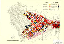
Land use - 1954
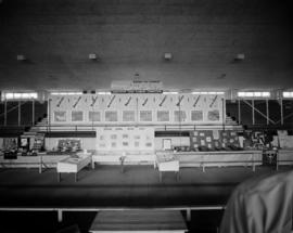
Vancouver Town Planning Commission display at P.N.E.

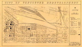
Redevelopment plan for Jericho Department of National Defence lands
![Stanley Park [Golden Jubilee]](/uploads/r/null/2/4/24135e2d726e60ffbc74f0d81c3a53d51a38fe9ea1e86ecda92708249adac23b/1b46df5d-6871-41b2-b1dd-91a0c1d5ad02-MAP624_142.jpg)
Stanley Park [Golden Jubilee]

A preliminary proposal for development of Jericho Park
![Commercial map of Greater Vancouver and district [assessment districts]](/uploads/r/null/0/9/2/0928add1a06ab55bc236f8bebb87712b7e6ad4422db32cc3065efe7c9da96c04/b5b4129d-f9ba-49b9-a863-2ab6e954897e-MAP102_142.jpg)
Commercial map of Greater Vancouver and district [assessment districts]

City of North Vancouver zone map showing "use" and "set-back" restrictions

False Creek development survey occupation plan

False Creek interim harbour headline
![News #2 [community forum on transportation and planning]](/images/generic-icons/audio.png)
News #2 [community forum on transportation and planning]

Point Grey, B.C. : district map

Preliminary report on civic centre

Existing service stations, retail shopping centres and commercial zoning : a basis for regulating location of service stations

Development in the western portion of the Lower Mainland region, 1968

Plan of the town of Newcastle, English Bay

Plan of sea wall site, Main Street, and surrounding properties

Redevelopment project no. 2 area a-6, including existing blocks 72, 73, 87, 88, D.L. 196 : site plan and general location of utilities plan no. 3

Part of area "a" : plan of redevelopment, Strathcona

Redevelopment Project No. 2 Plan No. 1

Project 2, part of area "a" : identification plan

Project 2, part of area "a" : utility diversions and rearrangements

Project 2, part of area "a" : plan of redevelopment

Project 2, part of area "a" : existing utilities, gas, electricity and telephone

Project 2, part of area "a" : existing utilities, water and sewer

Project 2, part of area "a" : pavements, curbs and sidewalks

Project 2, part of area "a" : condition of buildings

Project 2, part of area "a" : aerial photograph

Project 2 : generalized plan of redevelopment

Project 2, area "h" and part of "b" : proposed property acquisitions project 2

Project 2, area a-2 : proposed property acquisitions project 2
Project 2, area "h" and part of "b" : plan of redevelopment

Project 2 : generalized plan of redevelopment

Project 2: identification plan

Project 2, area a-2 : condition of buildings

Project 2, area "h" and part of "b" : condition of buildings

Project 2, area "h" and part of "b" : plan of redevelopment

Project 2, area "h" and part of "b" : existing gas, electricity and telephone

Project 2, area "h" and part of "b" : existing utilities, water and sewer

Project 2, area "h" and part of "b" : pavements, curbs and sidewalks

Project 2, area "h" and part of "b" : condition of buildings

Project 2, part of area "a" : identification plan

Project 2, part of area "a" : plan of redevelopment

Project 2, part of area "a" : existing gas, electricity and telephone

Project 2, part of area "a" : existing utilities, water and sewer

Project 2, part of area "a" : pavements, curbs and sidewalks

Project 2, part of area "a" : aerial photograph

Project 2, part of area "a" : condition of buildings

Project 2 : generalized plan of redevelopment

Rezoning application map (Point Grey Road)